|
|
 |
|

|
|
|
Water information extraction from high-resolution remote sensing images using the deep-learning based semantic segmentation model |
SHEN Jun’ao1( ), MA Mengting2, SONG Zhiyuan1, LIU Tingzhou1, ZHANG Wei1,2() ), MA Mengting2, SONG Zhiyuan1, LIU Tingzhou1, ZHANG Wei1,2() |
1. School of Software Technology, Zhejiang University, Ningbo 315048, China
2. School of Computer Science and Technology, Zhejiang University, Hangzhou 310027, China |
|
|
|
|
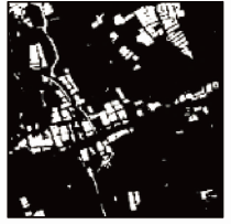
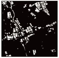
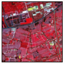
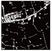
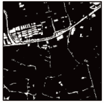
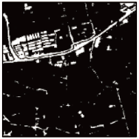
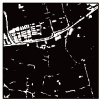
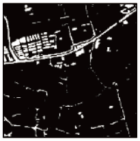
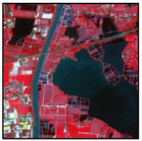
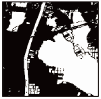
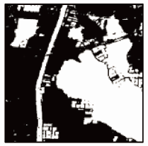
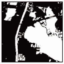
Abstract Water information extraction is an important study direction in the application of high spatial resolution remote sensing images. Conventional recognition methods only focus on the shallow features of water. Therefore, to further improve the robustness of water information extraction algorithms and increase the segmentation precision by extracting more deep information from remote sensing images, this study proposed a water classification method using the semantic segmentation model based on deep learning. First, deep neural networks were used to mine the information from high-resolution remote sensing images. Then, attention modules were used to integrate the deep information with the shallow features such as shape, structure, texture, and hue. Based on the integrated information, a new deep semantic segmentation model with higher precision and prediction efficiency than existent models was built. Finally, the ablation experiment was conducted to compare with conventional recognition methods and common semantic segmentation models. The experiment demonstrates that the proposed algorithm model yields higher overall precision and efficiency than previous methods and that the algorithm parameters are easy to set and less human intervention is required in the model. This study proved the accuracy and efficiency of deep learning and attention mechanism on water information extraction from high-resolution remote sensing images. Moreover, this study provided a possible solution for the segmentation of high-resolution remote sensing images using the deep learning method and explored the future prospect of the solution.
|
| Keywords
semantic segmentation
multi-scale
remote sensing image
full convolutional network
attention mechanism
|
|
|
|
Issue Date: 27 December 2022
|
|
|
| [1] |
方涛, 霍宏, 马贺平. 高分辨率遥感影像智能解译[M]. 北京: 科学出版社, 2016:18-25.
|
| [1] |
Fang T, Huo H, Ma H P. Intelligent interpretation of high resolution remote sensing image[M]. Beijing: Science Press, 2016:18-25.
|
| [2] |
Deng F L. Research on multi-level segmentation method and application of high resolution remote sensing image[D]. Beijing: University of Chinese Academy of Sciences, 2013.
|
| [3] |
Work E A, Gilmer D S. Utilization of satellite data for inventorying prairie ponds and lakes[J]. Photogrammetric Engineering and Remote Sensing, 1976, 42(5):685-694.
|
| [4] |
Frazier P S, Page K J. Water body detection and delineation with Landsat TM data[J]. Photogrammetric Engineering and Remote Sensing, 2000, 66(12):1461-1468.
|
| [5] |
McFeeters S K. The use of the normalized difference water index (NDWI) in the delineation of open water features[J]. International Journal of Remote Sensing, 1996, 17(7):1425-1432.
doi: 10.1080/01431169608948714
url: https://www.tandfonline.com/doi/full/10.1080/01431169608948714
|
| [6] |
Kaufman Y J, Tanre D. Atmospherically resistant vegetation index (ARVI) for EOS-MODIS[J]. IEEE Transactions on Geoscience and Remote Sensing, 1992, 30(2):261-270.
doi: 10.1109/36.134076
url: http://ieeexplore.ieee.org/document/134076/
|
| [7] |
Xu H Q. A study on information extraction of water body with the modified normalized difference water index (MNDWI)[J]. Journal of Remote Sensing, 2005, 9(5):589-595.
|
| [8] |
Lecun Y L, Bottou L, Bengio Y, et al. Gradient-based learning applied to document recognition[J]. Proceedings of the IEEE, 1998, 86(11):2278-2324.
doi: 10.1109/5.726791
url: http://ieeexplore.ieee.org/document/726791/
|
| [9] |
Krizhevsky A, Sutskever I, Hinton G. ImageNet classification with deep convolutional neural networks[J]. Advances in Neural Information Processing Systems, 2012, 25(2):1097-1105.
|
| [10] |
He K, Gkioxari G, Dollár P, et al. Mask R-CNN[C]// Proceedings of the IEEE International Conference on Computer Vision, 2017:2961-2969.
|
| [11] |
Long J, Shelhamer E, Darrell T. Fully convolutional networks for semantic segmentation[C]// Proceedings of the IEEE Conference on Computer Vision and Pattern Recognition, 2015:3431-3440.
|
| [12] |
许玥. 基于改进Unet的遥感影像语义分割在地表水体变迁中的应用[D]. 重庆: 重庆师范大学, 2019.
|
| [12] |
Xu Y. Application of semantic segmentation of remote sensing image based on improved Unet in surface water changes[D]. Chongqing: Chongqing Normal University, 2019.
|
| [13] |
Ying X, Wang Q, Li X, et al. Multi-attention object detection model in remote sensing images based on multi-scale[J]. IEEE Access, 2019, 7:94508-94519.
doi: 10.1109/ACCESS.2019.2928522
url: https://ieeexplore.ieee.org/document/8762136/
|
| [14] |
He N, Fang L, Plaza A. Hybrid first and second order attention U-net for building segmentation in remote sensing images[J]. Science China Information Sciences, 2020, 63(4):1-12.
|
| [15] |
Cortes C, Vapnik V. Support-vector networks[J]. Machine Learning, 1995, 20(3):273-297.
|
| [16] |
Hinton G E, Salakhutdinov R R. Reducing the dimensionality of data with neural networks[J]. Science, 2006, 313(5786):504-507.
doi: 10.1126/science.1127647
pmid: 16873662
|
| [17] |
Zhang X, Xiao P, Feng X, et al. Toward evaluating multiscale segmentations of high spatial resolution remote sensing images[J]. IEEE Transactions on Geoscience and Remote Sensing, 2015, 53(7):3694-3706.
doi: 10.1109/TGRS.2014.2381632
url: http://ieeexplore.ieee.org/document/7006740/
|
| [18] |
Chen L C, Papandreou G, Kokkinos I, et al. Deeplab:Semantic image segmentation with deep convolutional nets,atrous convolution,and fully connected CRFs[J]. IEEE Transactions on Pattern Analysis and Machine Intelligence, 2017, 40(4):834-848.
doi: 10.1109/TPAMI.2017.2699184
url: http://ieeexplore.ieee.org/document/7913730/
|
| [19] |
Zhao H, Shi J, Qi X, et al. Pyramid scene parsing network[C]// Proceedings of the IEEE Conference on Computer Vision and Pattern Recognition, 2017:2881-2890.
|
| [20] |
Ronneberger O, Fischer P, Brox T. U-net:Convolutional networks for biomedical image segmentation[C]// International Conference on Medical Image Computing and Computer-Assisted Intervention. Cham:Springer, 2015:234-241.
|
|
Viewed |
|
|
|
Full text
|
|
|
|
|
Abstract
|
|
|
|
|
Cited |
|
|
|
|
| |
Shared |
|
|
|
|
| |
Discussed |
|
|
|
|
 2022,
Vol. 34
2022,
Vol. 34