Please wait a minute...
 
Remote Sensing for Natural Resources    2025, Vol. 37 Issue (4) : 31-39     DOI: 10.6046/zrzyyg.2024154
|
Multi-scale residual dehazing network for remote sensing images based on dual attention
LI Yuan1(), FU Hui2, LIU Haozhi1
1. Nanchong Vocational and Technical College, Nanchong 637000, China
2. College of Electrical and Information Engineering, Lanzhou University of Technology, Lanzhou 730050, China
Download: PDF(4952 KB)   HTML
Export: BibTeX | EndNote | Reference Manager | ProCite | RefWorks    
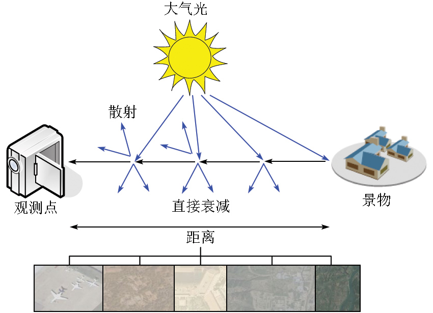
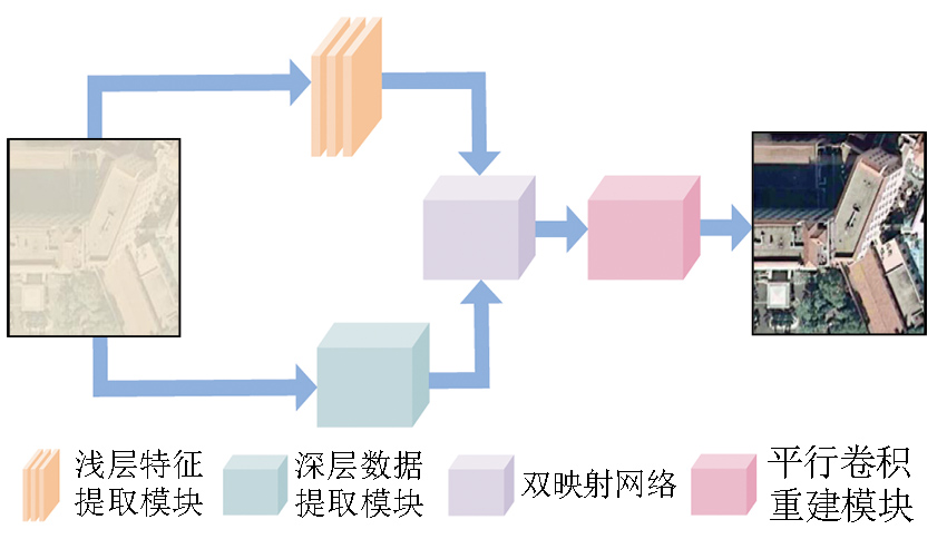
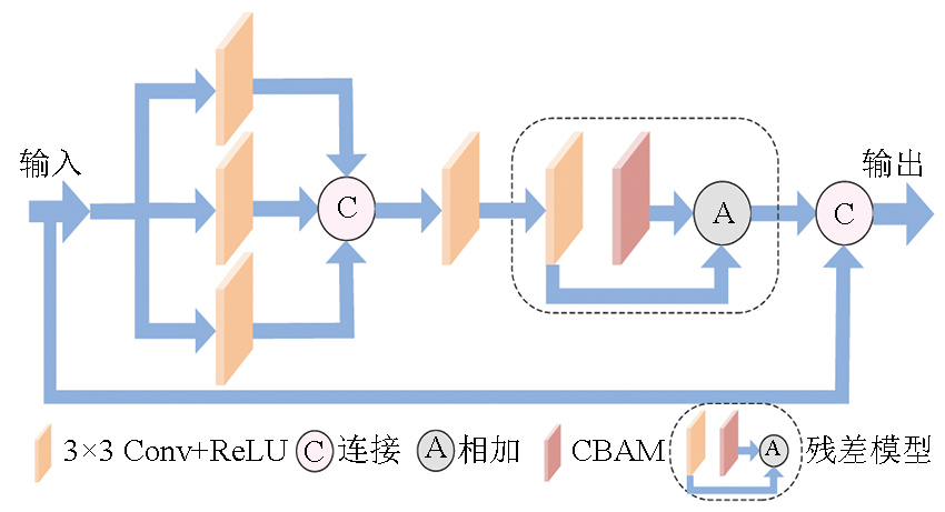
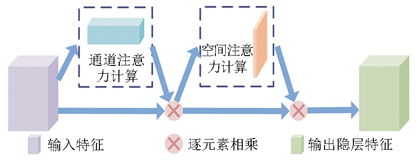
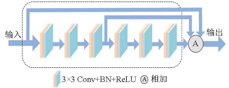
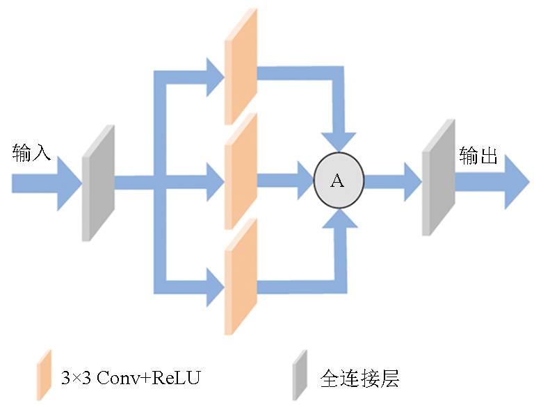
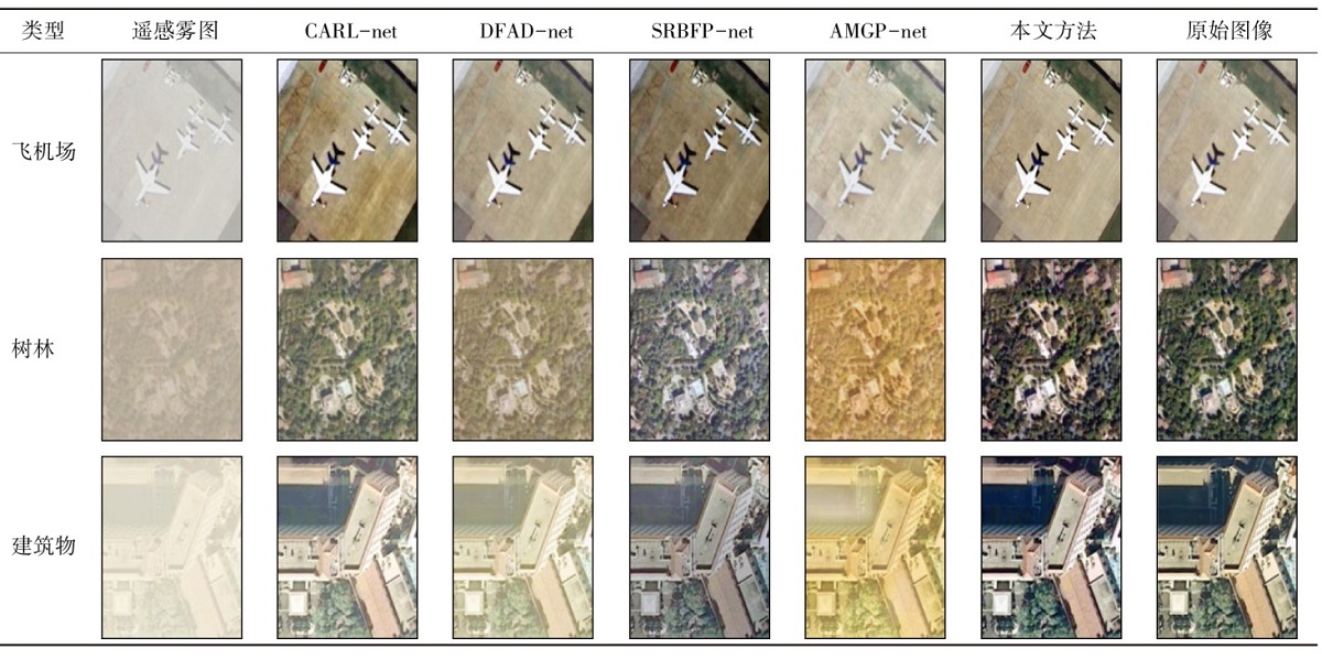
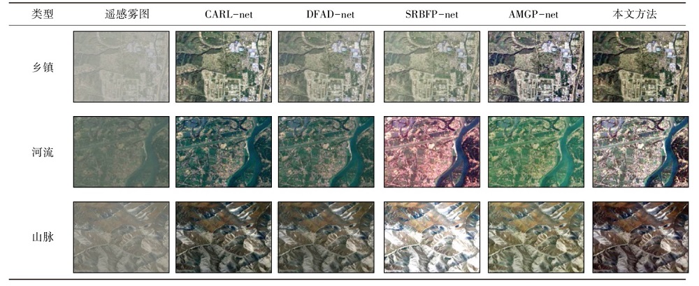
Abstract  

Hazes reduce the quality of remote sensing images while limiting the performance of back-end visual applications. Hence, this study proposed a multi-scale residual dehazing network based on dual attention. First, an atmospheric scattering model was constructed to combine the atmospheric light value and transmissivity to derive the atmospheric power of light. Second, an end-to-end deep learning model was used to clarify remote sensing images with hazes. The dehazing network consists of a shallow feature extraction module, a deep data extraction module, a dual mapping network, and a parallel convolution reconstruction module. Finally, the proposed dehazing network was compared with CARL-net, DFAD-net, SRBFP-net, and AMGP-net through subjective and objective comparison experiments. The results indicate that the proposed dehazing network obtained a visual state close to the original haze-free scene, exhibiting high contrast, bright chroma, corresponding saturation, and clear transmission map details. Moreover, it effectively removed image noise while maintaining the edge of the foreground part. Compared to the above four networks, the proposed dehazing network achieved superior peak signal-to-noise ratio (PSNR) and structure similarity index measure (SSIM), higher algorithm processing efficiency, and stable algorithm processing time with the increase of image resolution.

Keywords attention      residual      atmospheric power of light      end-to-end      dual mapping     
ZTFLH:  TP407  
Issue Date: 03 September 2025
Service
E-mail this article
E-mail Alert
RSS
Articles by authors
Yuan LI
Hui FU
Haozhi LIU
Cite this article:   
Yuan LI,Hui FU,Haozhi LIU. Multi-scale residual dehazing network for remote sensing images based on dual attention[J]. Remote Sensing for Natural Resources, 2025, 37(4): 31-39.
URL:  
https://www.gtzyyg.com/EN/10.6046/zrzyyg.2024154     OR     https://www.gtzyyg.com/EN/Y2025/V37/I4/31
Fig.1  Physical model of atmospheric scattering
Fig.2  Multi-scale residual dehazing network based on dual attention
Fig.3  Multi-scale residual attention model
Fig.4  CBAM structure
Fig.5  Dual mapping network module
Fig.6  Parallel convolution reconstruction module
Tab.1  Comparison of clarity effect of synthetic remote sensing images with hazes
Tab.2  Comparison of clarity effect of real remote sensing images with hazes
Tab.3  Comparison of transmission images
方法 指标 数据集
真实雾图集 合成雾图集
CARL-net PSNR 18.250 9 18.469 1
SSIM 0.815 6 0.802 2
DFAD-net PSNR 17.272 5 17.561 8
SSIM 0.779 5 0.765 8
SRBFP-net PSNR 15.984 2 16.115 3
SSIM 0.837 1 0.825 9
AMGP-net PSNR 18.951 8 19.101 4
SSIM 0.732 6 0.743 8
本文方法 PSNR 20.926 1 21.260 9
SSIM 0.912 8 0.908 9
Tab.4  Comparison of full-reference objective evaluation indicators of different methods
方法 指标 数据集
真实雾图集 合成雾图集
CARL-net PSNR 0.729 3 0.728 7
SSIM 0.730 3 0.676 9
SEP 1.459 6 1.405 6
DFAD-net PSNR 0.630 3 0.640 6
SSIM 0.630 1 0.566 6
SEP 1.620 4 1.207 2
SRBFP-net PSNR 0.500 0 0.500 0
SSIM 0.790 0 0.748 6
SEP 1.290 0 1.248 6
AMGP-net PSNR 0.800 2 0.790 2
SSIM 0.500 0 0.500 0
SEP 1.300 2 1.290 2
本文方法 PSNR 1.000 0 1.000 0
SSIM 1.000 0 1.000 0
SEP 2.000 0 2.000 0
Tab.5  Normalized comparison of full-reference objective evaluation indicators of different methods
Fig.7  Normalized histogram of full-reference objective evaluation indicators of different methods
Tab.6  Comparison of ablation results between synthetic and real remote sensing images with hazes
指标 模型A 模型B 模型C 模型D 模型E
PSNR 15.113 2 15.891 4 20.138 2 18.472 5 21.260 9
SSIM 0.625 3 0.703 1 0.874 5 0.842 6 0.908 9
Tab.7  Comparison of ablation parameters of synthetic remote sensing images with hazes
指标 模型A 模型B 模型C 模型D 模型E
PSNR 15.412 8 15.892 7 20.102 1 18.215 3 20.926 1
SSIM 0.652 3 0.719 2 0.853 1 0.815 6 0.912 8
Tab.8  Comparison of ablation parameters of real remote sensing images with hazes
类型 说明 种类 卷积
核数
卷积核
大小
参数量
输入层 输入
特征提
取模块
浅层特征
提取模块
Conv+ReLU 32 3×3 896
深层数据
提取模块
Conv 32 3×3 896
Conv 32 3×3 896
Conv 32 3×3 896
Conv+ReLU 64 3×3 55 360
Conv+ReLU 64 3×3 36 928
映射
网络
双映射网络 Conv
BN+ReLU
64
3×3
36 928

Conv
BN+ReLU
64
3×3
36 928
Conv
BN+ReLU
64
3×3
36 928
Conv
BN+ReLU
64
3×3
36 928
Conv
BN+ReLU
64
3×3
36 928
Conv
BN+ReLU
64
3×3
36 928
输出层 平行卷积
重建模块
Conv+ReLU 4 096 1×1 266 240
Conv+ReLU 128 3×3 4 718 720
Conv+ReLU 128 3×3 147 584
Conv+ReLU 4 096 1×1 528 384
总计 6 127 744
Tab.9  Parameter quantity of the proposed method
方法 分辨率
330×220 640×480 780×500 950×650
CARL-net 1 089.5 2 395.4 3 051.3 4 182.1
DFAD-net 627.3 1 804.8 2 409.5 3 091.4
SRBFP-net 451.2 1 161.3 1 485.9 2 465.3
AMGP-net 609.4 1 585.9 2 233.5 2 669.3
本文方法 618.2 1 636.1 2 293.6 2 538.4
Tab.10  Comparison of processing efficiency of different methods(ms)
[1] 单慧琳, 王硕洋, 童俊毅, 等. 增强小目标特征的多尺度光学遥感图像目标检测[J]. 光学学报, 2024, 44(6):382-394.
[1] Shan H L, Wang S Y, Tong J Y, et al. Multi-scale optical remote sensing image target detection based on enhanced small target features[J]. Acta Optica Sinica, 2024, 44(6):382-394.
[2] 孙航, 方帅领, 但志平, 等. 层级特征交互与增强感受野双分支遥感图像去雾网络[J]. 遥感学报, 2023, 27(12):2831-2846.
[2] Sun H, Fang S L, Dan Z P, et al. A two-branch remote sensing image dehazing network based on hierarchical feature interaction and enhanced receptive field[J]. National Remote Sensing Bulletin, 2023, 27(12):2831-2846.
[3] 王科平, 杨艺, 费树岷. 雾霾图像清晰化算法综述[J]. 智能系统学报, 2023, 18(2):217-230.
[3] Wang K P, Yang Y, Fei S M. Review of hazy image sharpening methods[J]. CAAI Transactions on Intelligent Systems, 2023, 18(2):217-230.
[4] Feng X, Tan J Q, Ge X Y, et al. Blind image deblurring via weighted dark channel prior[J]. Circuits,Systems,and Signal Processing, 2023, 42(9):5478-5499.
[5] 连文杰, 叶少珍. 注意力机制下的多层次特征融合图像去雾算法[J]. 福州大学学报(自然科学版), 2024, 52(1):7-13.
[5] Lian W J, Ye S Z. Image dehazing algorithm based on multi-level feature fusion and attention mechanism[J]. Journal of Fuzhou University (Natural Science Edition), 2024, 52(1):7-13.
[6] Frants V, Agaian S, Panetta K. QCNN-H:Single-image dehazing using quaternion neural networks[J]. IEEE Transactions on Cybernetics, 2023, 53(9):5448-5458.
[7] Yang Y Z, Hou C, Huang H X, et al. Cascaded deep residual learning network for single image dehazing[J]. Multimedia Systems, 2023, 29(4):2037-2048.
[8] Liu J L, Yu H, Zhang Z Z, et al. Deep multi-scale network for single image dehazing with self-guided maps[J]. Signal,Image and Video Processing, 2023, 17(6):2867-2875.
[9] Hao Y, Jiang W Z, Liu W F, et al. Dynamic feature attention network for remote sensing image dehazing[J]. Neural Processing Letters, 2023, 55(6):8081-8094.
[10] 唐剑, 车文刚, 高盛祥. 融入注意力机制的多尺度卷积图像去雾方法[J]. 计算机工程与科学, 2023, 45(8):1453-1462.
[10] Tang J, Che W G, Gao S X. An image dehazing method based on multi-scale convolution with attention mechanism[J]. Computer Engineering and Science, 2023, 45(8):1453-1462.
[11] Chen Y, Lyu Z, Hou Y M. IPDNet:A dual convolutional network combined with image prior for single image dehazing[J]. Engineering Applications of Artificial Intelligence, 2023, 126:106782.
[12] 王科平, 肖梦临. 基于增强型金字塔及图像超分辨率去雾网络[J]. 兵器装备工程学报, 2023, 44(11):299-307.
[12] Wang K P, Xiao M L. Based on image super-resolution and boost-ed feature pyramid dehazing network[J]. Journal of Ordnance Equipment Engineering, 2023, 44(11):299-307.
[13] 张浩文, 杨燕, 张金龙, 等. 基于注意力与多尺度分组并联网络的去雾算法[J]. 传感器与微系统, 2023, 42(10):151-155.
[13] Zhang H W, Yang Y, Zhang J L, et al. Dehazing algorithm based on attention and multi-scale grouping parallel network[J]. Transducer and Microsystem Technologies, 2023, 42(10):151-155.
[14] 唐斌, 陈清容, 段春红. 基于大气散射模型的图像去雾及亮度增强算法[J]. 光电子·激光, 2024, 35(3):303-310.
[14] Tang B, Chen Q R, Duan C H. Image dehazing and brightness enhancement algorithm based on atmospheric scattering model[J]. Journal of Optoelectronics·Laser, 2024, 35(3):303-310.
[15] 刘宇佳, 谢诗哲, 杜阳, 等. 结合空间语义注意力的二段式遥感图像修复网络[J]. 自然资源遥感, 2024, 36(1):58-66.doi:10.6046/gtzyyg.2022362.
[15] Liu Y J, Xie S Z, Du Y, et al. A two-stage remote sensing image inpainting network combined with spatial semantic attention[J]. Remote Sensing for Natural Resources, 2024, 36(1):58-66.doi:10.6046/gtzyyg.2022362.
[16] He K M, Sun J, Tang X O. Guided image filtering[J]. IEEE Transactions on Pattern Analysis and Machine Intelligence, 2013, 35(6):1397-1409.
[1] LI Zhi, ZHANG Shubi, LI Minggeng, CHEN Qiang, BIAN Hefang, LI Shijin, GAO Yandong, ZHANG Yansuo, ZHANG Di. Stacking-assisted DS-InSAR method for monitoring surface deformations in complex mining areas[J]. Remote Sensing for Natural Resources, 2025, 37(4): 12-20.
[2] ZHANG Qiao, CAO Zhicheng, SHEN Yang, WANG Zhoufeng, WANG Chengwu, XU Jiaxin. A method combining the siamese inverted residual structure with self-attention enhancement for change detection based on remote sensing images[J]. Remote Sensing for Natural Resources, 2025, 37(3): 85-94.
[3] YE Wujian, XIE Linfeng, LIU Yijun, WEN Xiaozhuo, Li Yang. A MobileNet-based lightweight cloud detection model[J]. Remote Sensing for Natural Resources, 2025, 37(3): 95-103.
[4] GUO Wei, LI Yu, JIN Haibo. Detecting ships from SAR images based on high-dimensional contextual attention and dual receptive field enhancement[J]. Remote Sensing for Natural Resources, 2025, 37(3): 104-112.
[5] LIU Chenchen, GE Xiaosan, WU Yongbin, YU Haikun, ZHANG Beibei. A method for information extraction of buildings from remote sensing images based on hybrid attention mechanism and Deeplabv3+[J]. Remote Sensing for Natural Resources, 2025, 37(1): 31-37.
[6] QU Haicheng, WANG Ying, LIU Lamei, HAO Ming. Information extraction of roads from remote sensing images using CNN combined with Transformer[J]. Remote Sensing for Natural Resources, 2025, 37(1): 38-45.
[7] HU Boyang, SUN Jianguo, ZHANG Qian, YANG Yunrui. Residual trend method based on regional modeling and machine learning for attribution of vegetation changes[J]. Remote Sensing for Natural Resources, 2025, 37(1): 46-53.
[8] WEI Xiao, ZHANG Lifeng, HE Yi, CAO Shengpeng, SUN Qiang, GAO Binghai. 2000-2020 spatiotemporal variations of different vegetation types in the Yellow River basin and influencing factors[J]. Remote Sensing for Natural Resources, 2024, 36(4): 229-241.
[9] ZHENG Zongsheng, WANG Zhenghan, WANG Zhenhua, LU Peng, GAO Meng, HUO Zhijun. An improved 3D Octave convolution-based method for hyperspectral image classification[J]. Remote Sensing for Natural Resources, 2024, 36(4): 82-91.
[10] QU Haicheng, LIANG Xu. Building extraction from high-resolution images using a hybrid attention mechanism combined with multi-scale feature enhancement[J]. Remote Sensing for Natural Resources, 2024, 36(4): 107-116.
[11] LIU Yujia, XIE Shizhe, DU Yang, YAN Jin, NAN Yanyun, WEN Zhongkai. A two-stage remote sensing image inpainting network combined with spatial semantic attention[J]. Remote Sensing for Natural Resources, 2024, 36(1): 58-66.
[12] DENG Dingzhu. Deep learning-based cloud detection method for multi-source satellite remote sensing images[J]. Remote Sensing for Natural Resources, 2023, 35(4): 9-16.
[13] CHEN Di, PENG Qiuzhi, HUANG Peiyi, LIU Yaxuan. Detecting land for photovoltaic development based on the attention mechanism and improved YOLOv5[J]. Remote Sensing for Natural Resources, 2023, 35(4): 90-95.
[14] NIU Xianghua, HUANG Wei, HUANG Rui, JIANG Sili. A high-fidelity method for thin cloud removal from remote sensing images based on attentional feature fusion[J]. Remote Sensing for Natural Resources, 2023, 35(3): 116-123.
[15] LIN Jiahui, LIU Guang, FAN Jinghui, ZHAO Hongli, BAI Shibiao, PAN Hongyu. Extracting information about mining subsidence by combining an improved U-Net model and D-InSAR[J]. Remote Sensing for Natural Resources, 2023, 35(3): 145-152.
Viewed
Full text


Abstract

Cited

  Shared   
  Discussed   
京ICP备05055290号-2
Copyright © 2017 Remote Sensing for Natural Resources
Support by Beijing Magtech