|
|
 |
|
|
|
|
Relationship between modified water stress-based NPP inversion and soil moisture in typical plateau basins |
YANG Zhen1,2( ), YANG Minglong1,2(), LI Guozhu1,3, XIA Yonghua1,2, YU Ting4, YAN Zhengfei1,2, LI Wantao1,2 ), YANG Minglong1,2(), LI Guozhu1,3, XIA Yonghua1,2, YU Ting4, YAN Zhengfei1,2, LI Wantao1,2 |
1. Faculty of Land Resources Engineering,Kunming University of Science and Technology,Kunming 650093,China
2. Surveying and Mapping Geo-informatics Technology Research Center on Plateau Mountains of Yunnan Higher Education,Kunming 650093,China
3. Yunnan Haiju Geographic Information Technology Co.,Ltd.,Kunming 650000,China
4. Yunnan Institute of Water Resources and Hydropower Research,Kunming 650228,China |
|
|
|
|
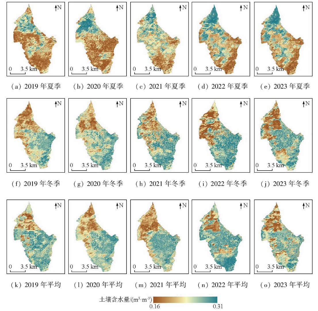
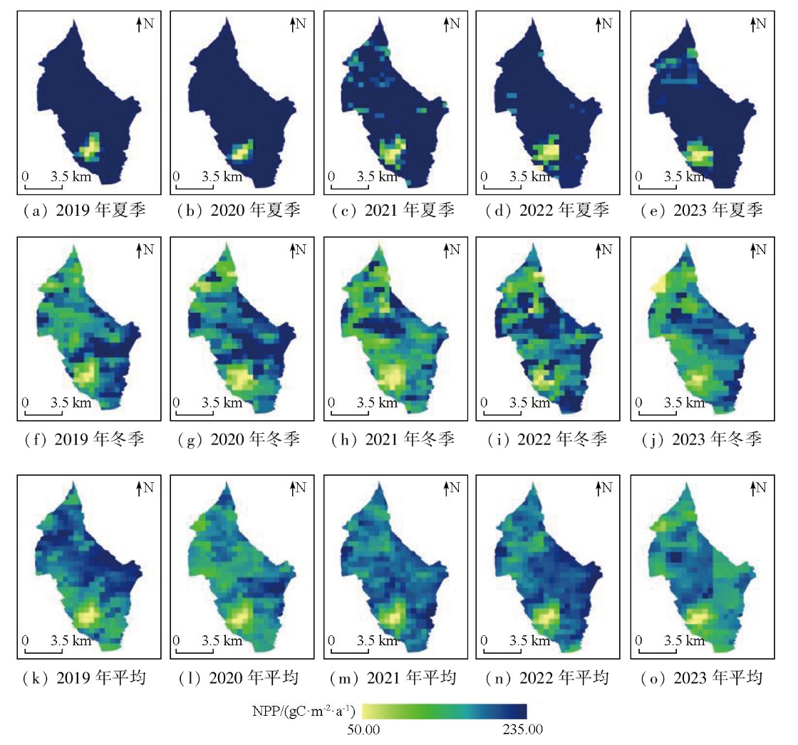
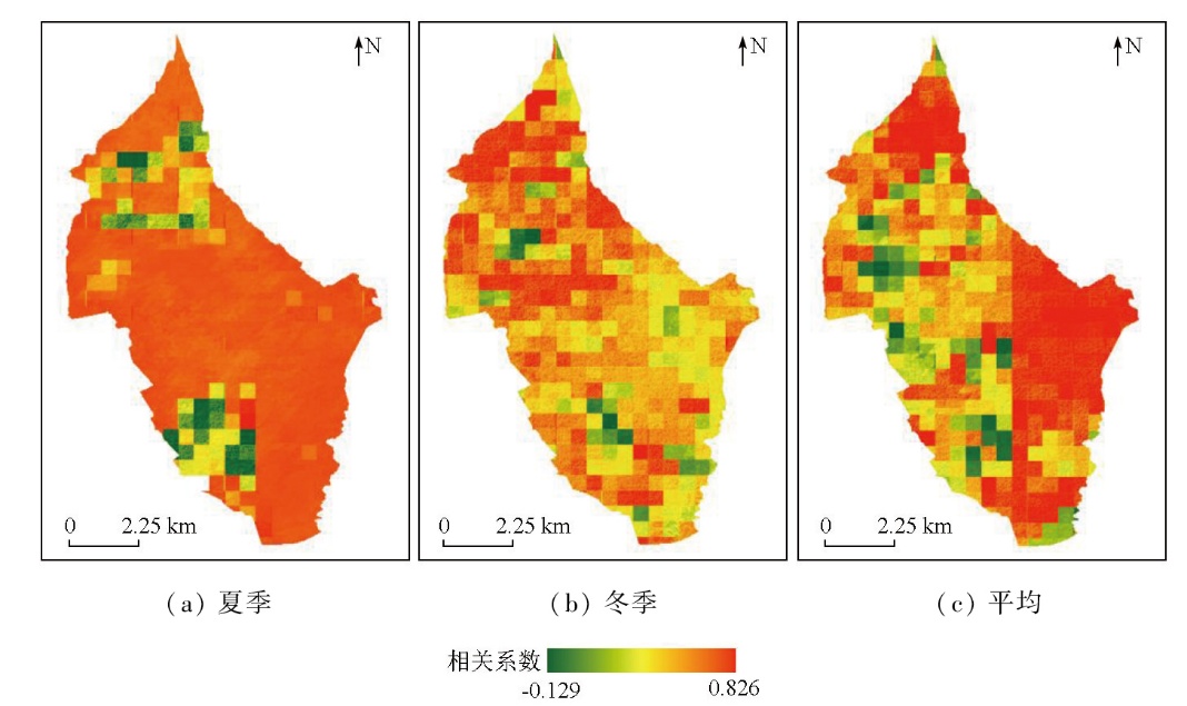
Abstract This study aims at investigating variations in soil moisture and vegetation net primary productivity (NPP) in the Qingling River Irrigation Area,Yunnan (elevation 1 515~1 876 m),a typical subtropical alpine climate region. To this end,initially,this study recognized land surface temperature (LST) and normalized difference vegetation index (NDVI) as explanatory variables,leveraging remote sensing technology for rapid and long-term sequential monitoring. Subsequently,the SMAP L4 soil moisture product was downscaled to a 30 m spatial resolution using the random forest adaptive window regression algorithm. Then,the water stress parameter of the CASA model was modified using the land surface water index (LSWI),which integrated multi-source remote sensing data,such as surface reflectance,to estimate NPP. Following spatial resampling,a 30 m resolution NPP spatial distribution was achieved. Finally,multiple land cover scenarios,including forest land,paddy fields,and irrigated farmland,were established. The Pearson correlation coefficient was introduced for the quantitative evaluation of the spatial relationship between soil moisture and NPP in the study area. In terms of the spatial distribution of soil moisture,the study area exhibited higher values in the north and lower values in the south during summer,while lower values in the northwest and higher values in the southeast and south during winter. Compared to field measurements,the inverted NPP results showed a R2>0.7 and a RMSE<0.3. Both summer,winter,and annual average NPP values at the pixel level showed an increasing trend over time. Spatially,scenarios such as paddy fields and forested land presented correlation coefficients exceeding 0.5. Among these,forest land was least sensitive to water stress,while paddy fields and irrigated farmland were most affected. This study establishes a monitoring and feedback mechanism for the soil moisture-NPP balance from seasonal and spatial perspectives in the study area.
|
| Keywords
plateau irrigation area
multi-source remote sensing data
soil moisture
downscaling analysis
net primary productivity (NPP)
|
|
|
|
Issue Date: 28 October 2025
|
|
|
| [1] |
Xie C H, Wu S X, Zhuang Q W, et al. Where anthropogenic activity occurs,anthropogenic activity dominates vegetation net primary productivity change[J]. Remote Sensing, 2022, 14(5):1092.
|
| [2] |
张育斌, 张丽娜, 王军德. 陇中旱作区玉米全膜宽窄行种植对土壤水分及产量的影响[J]. 节水灌溉, 2023(12):9-17.
doi: 10.12396/jsgg.2023226
|
| [2] |
Zhang Y B, Zhang L N, Wang J D. Effects of full-film wide and narrow row planting of corn on soil moisture and yield in central Gansu dry farming area[J]. Water Saving Irrigation, 2023(12):9-17.
|
| [3] |
Chen X, Zhang Y P. Impacts of climate,phenology,elevation and their interactions on the net primary productivity of vegetation in Yunnan,China under global warming[J]. Ecological Indicators, 2023, 154:110533.
|
| [4] |
原晋涛, 陈万旭, 曾杰. 中国耕地利用变化时空分异特征及对耕地NPP的影响[J]. 自然资源学报, 2023, 38(12):3135-3149.
doi: 10.31497/zrzyxb.20231212
|
| [4] |
Yuan J T, Chen W X, Zeng J. Spatio-temporal differentiation of cropland use change and its impact on cropland NPP in China[J]. Journal of Natural Resources, 2023, 38(12):3135-3149.
|
| [5] |
田东哲, 吴苏, 徐梦帅, 等. 基于涡度相关法的森林生态系统碳通量观测研究[J]. 现代信息科技, 2022, 6(11):149-152.
|
| [5] |
Tian D Z, Wu S, Xu M S, et al. Observational research on carbon flux of forest ecosystem based on eddy covariance[J]. Modern Information Technology, 2022, 6(11):149-152.
|
| [6] |
吴旗韬, 李苑君, 石喜平, 等. 基于叶绿素测定法的广东省典型水库初级生产力评估[J]. 水产养殖, 2022, 43(10):4-8.
|
| [6] |
Wu Q T, Li Y J, Shi X P, et al. Primary productivity assessment of typical reservoirs in Guangdong Province based on chlorophyll measurement[J]. Journal of Aquaculture, 2022, 43(10):4-8.
|
| [7] |
方浩玲, 程先富, 秦丽. 安徽省植被净初级生产力估算——基于改进的CASA模型[J]. 生态学报, 2024, 44(4):1601-1612.
|
| [7] |
Fang H L, Cheng X F, Qin L. Estimation of net primary productivity of vegetation in Anhui Province based on improved CASA model[J]. Acta Ecologica Sinica, 2024, 44(4):1601-1612.
|
| [8] |
徐勇, 周清华, 窦世卿, 等. 基于ZGS和TW模型的长江流域植被NPP时空演变特征[J]. 水土保持通报, 2022, 42(1):225-232.
|
| [8] |
Xu Y, Zhou Q H, Dou S Q, et al. Spatiotemporal characteristics of vegetation net primary productivity in Yangtze River Basin based on ZGS and Thornthwaite Memorial models[J]. Bulletin of Soil and Water Conservation, 2022, 42(1):225-232.
|
| [9] |
贾畅, 王丽娜, 唐亚坤. 利用Biome-BGC模型模拟黄土区沙棘人工林碳通量时的生理生态参数敏感性[J]. 林业科学, 2022, 58(11):49-60.
|
| [9] |
Jia C, Wang L N, Tang Y K. Sensitivity analysis of ecophysiological parameters for the simulated carbon flux using the Biome-BGC model in a Hippophae rhamnoides plantation in the loess region[J]. Scientia Silvae Sinicae, 2022, 58(11):49-60.
|
| [10] |
Yu D Y, Shi P J, Shao H B, et al. Modelling net primary productivi-ty of terrestrial ecosystems in East Asia based on an improved CASA ecosystem model[J]. International Journal of Remote Sensing, 2009, 30(18):4851-4866.
|
| [11] |
尚天浩, 贾萍萍, 孙媛, 等. 宁夏银北地区盐碱化土壤水分光谱特征及模型拟合精度分析[J]. 水土保持通报, 2020, 40(4):183-189.
|
| [11] |
Shang T H, Jia P P, Sun Y, et al. Spectral characteristics of soil moisture in salinized soil and model fitting accuracy in northern Yinchua City,Ningxia Hui Autonomous Region[J]. Bulletin of Soil and Water Conservation, 2020, 40(4):183-189.
|
| [12] |
张兆旭, 崔津, 苟文涛, 等. 基于温度植被干旱指数的华北平原干旱监测及时空变化分析[J]. 农业大数据学报, 2023, 5(1):95-107.
doi: 10.19788/j.issn.2096-6369.230118
|
| [12] |
Zhang Z X, Cui J, Gou W T, et al. Drought monitoring and spatiotemporal changes analysis in North China Plain based on temperature vegetation dryness index[J]. Journal of Agricultural Big Data, 2023, 5(1):95-107.
doi: 10.19788/j.issn.2096-6369.230118
|
| [13] |
王锡刚. 基于水云模型标定的土壤水分反演研究[D]. 长春: 吉林大学, 2023.
|
| [13] |
Wang X G. Research on soil moisture retrieval based on the calibration of water cloud model[D]. Changchun: Jilin University, 2023.
|
| [14] |
赵伟, 文凤平, 蔡俊飞. 被动微波土壤水分遥感产品空间降尺度研究:方法、进展及挑战[J]. 遥感学报, 2022, 26(9):1699-1722.
|
| [14] |
Zhao W, Wen F P, Cai J F. Methods,progresses,and challenges of passive microwave soil moisture spatial downscaling[J]. National Remote Sensing Bulletin, 2022, 26(9):1699-1722.
|
| [15] |
张国平, 王红丽, 张绪成, 等. 不同治理模式对玛曲沙化草原生态恢复过程中土壤水分和植被净初级生产力的影响[J]. 甘肃农业科技, 2022, 53(4):58-63.
|
| [15] |
Zhang G P, Wang H L, Zhang X C, et al. Effects of different governance modes on soil moisture and vegetation net primary productivity during the ecological restoration of desertified grassland in Maqu County[J]. Gansu Agricultural Science and Technology, 2022, 53(4):58-63.
|
| [16] |
付石林, 雷加强, 周仪琪, 等. 基于植被净初级生产力和水分利用效率的埃塞俄比亚土地退化趋势及驱动因素分析[J]. 中国沙漠, 2023, 43(1):128-141.
doi: 10.7522/j.issn.1000-694X.2022.00074
|
| [16] |
Fu S L, Lei J Q, Zhou Y Q, et al. Analysis of land degradation trends and driving factors in Ethiopia based on NPP-WUE[J]. Journal of Desert Research, 2023, 43(1):128-141.
|
| [17] |
岳东霞, 牟鑫亮, 周妍妍, 等. 疏勒河流域净初级生产力与土壤含水量耦合关系研究[J]. 兰州大学学报(自然科学版), 2021, 57(4):518-527,536.
|
| [17] |
Yue D X, Mu X L, Zhou Y Y, et al. Coupling relationship between net primary productivity and soil moisture content in the Shule River Basin[J]. Journal of Lanzhou University (Natural Sciences), 2021, 57(4):518-527,536.
|
| [18] |
文凤平. 基于值域一致性的SMAP被动微波土壤水分产品空间降尺度研究[D]. 成都: 中国科学院大学(中国科学院水利部成都山地灾害与环境研究所), 2020.
|
| [18] |
Wen F P. Spatial downscaling of SMAP passive microwave soil moisture products based on range consistency[D]. Chengdu: Institute of Mountain Hazards and Environment,Chinese Academy of Sciences, 2020.
|
| [19] |
Jiang Y Z, Yang K, Shao C K, et al. A downscaling approach for constructing high-resolution precipitation dataset over the Tibetan Plateau from ERA5 reanalysis[J]. Atmospheric Research, 2021, 256:105574.
|
| [20] |
梁文海, 刘吉凯, 陈琦, 等. 基于面向对象方法的GF-2影像桉树信息提取对比分析[J]. 林业资源管理, 2017(6):54-59.
|
| [20] |
Liang W H, Liu J K, Chen Q, et al. A comparison of object-oriented methods of extracting Eucalyptus information based on GF-2 images[J]. Forest Resources Management, 2017(6):54-59.
|
| [21] |
Guan D J, Nie J L, Zhou L L, et al. How to simulate carbon sequestration potential of forest vegetation? A forest carbon sequestration model across a typical mountain city in China[J]. Remote Sensing, 2023, 15(21):5096.
|
| [22] |
Bao G, Bao Y H, Qin Z H, et al. Modeling net primary productivity of terrestrial ecosystems in the semi-arid climate of the Mongolian Plateau using LSWI-based CASA ecosystem model[J]. International Journal of Applied Earth Observation and Geoinformation, 2016, 46:84-93.
|
| [23] |
Zhang X L, Xiao W H, Wang Y C, et al. Spatial-temporal changes in NPP and its relationship with climate factors based on sensitivity analysis in the Shiyang River Basin[J]. Journal of Earth System Science, 2019, 129(1):24.
|
| [24] |
Wu C Y, Chen K L, et al. Improved CASA model based on satellite remote sensing data:Simulating net primary productivity of Qinghai Lake Basin alpine grassland[J]. Geoscientific Model Development, 2022, 15(17):6919-6933.
|
| [25] |
Abdi A M, Vrieling A, Yengoh G T, et al. The El Niño-La Niña cycle and recent trends in supply and demand of net primary productivity in African drylands[J]. Climatic Change, 2016, 138(1):111-125.
|
| [26] |
Hou G Y, Wu S X, Long W Y, et al. Quantitative analysis of the impact of climate change and oasification on changes in net primary productivity variation in mid-Tianshan Mountains from 2001 to 2020[J]. Ecological Indicators, 2023, 154:110820.
|
| [27] |
Ding H, Yuan Z, Shi X L, et al. Soil moisture content-based analysis of terrestrial ecosystems in China:Water use efficiency of vegetation systems[J]. Ecological Indicators, 2023, 150:110271.
|
| [28] |
Yin C H, Luo M, Meng F H, et al. Contributions of climatic and anthropogenic drivers to net primary productivity of vegetation in the Mongolian Plateau[J]. Remote Sensing, 2022, 14(14):3383.
|
|
Viewed |
|
|
|
Full text
|
|
|
|
|
Abstract
|
|
|
|
|
Cited |
|
|
|
|
| |
Shared |
|
|
|
|
| |
Discussed |
|
|
|
|
 2025,
Vol. 37
2025,
Vol. 37