|
|
 |
|

|
|
|
A remote sensing methodology for predicting geothermal resources in the Wugongshan uplift zone |
CHEN Yan1,2( ), YUAN Jing1,2,3, TANG Chunhua1,2(), SUN Chao1,2, TANG Xiao1,2, WANG Mingyou1,2 ), YUAN Jing1,2,3, TANG Chunhua1,2(), SUN Chao1,2, TANG Xiao1,2, WANG Mingyou1,2 |
1. Basic Geological Survey Institute of Jiangxi Geological Survey and Exploration Institute, Nanchang 330030, China
2. Jiangxi Non-ferrous Geology and Mineral Exploration and Development Institute, Nanchang 330030, China
3. School of Earth Sciences and Resources, China University of Geosciences (Beijing), Beijing 100083, China |
|
|
|
|
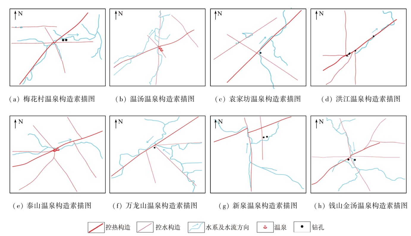
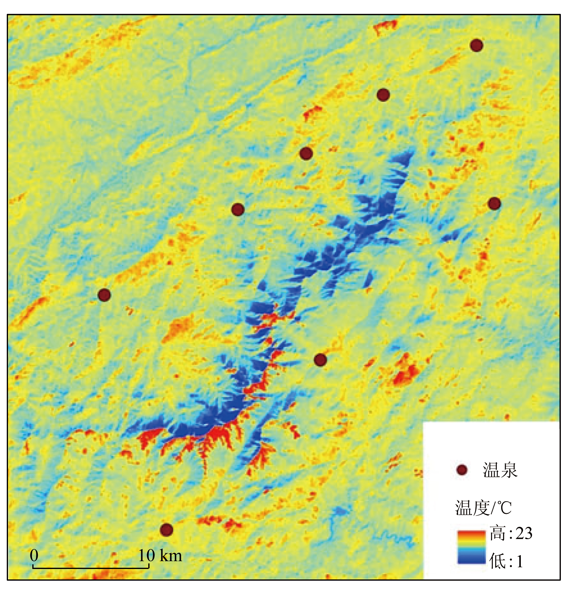
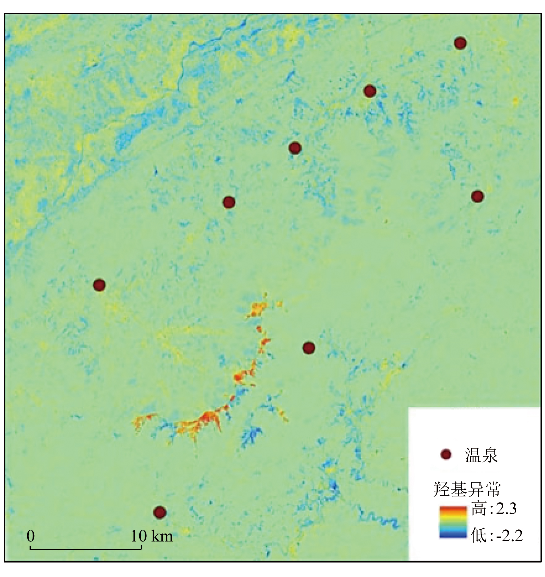
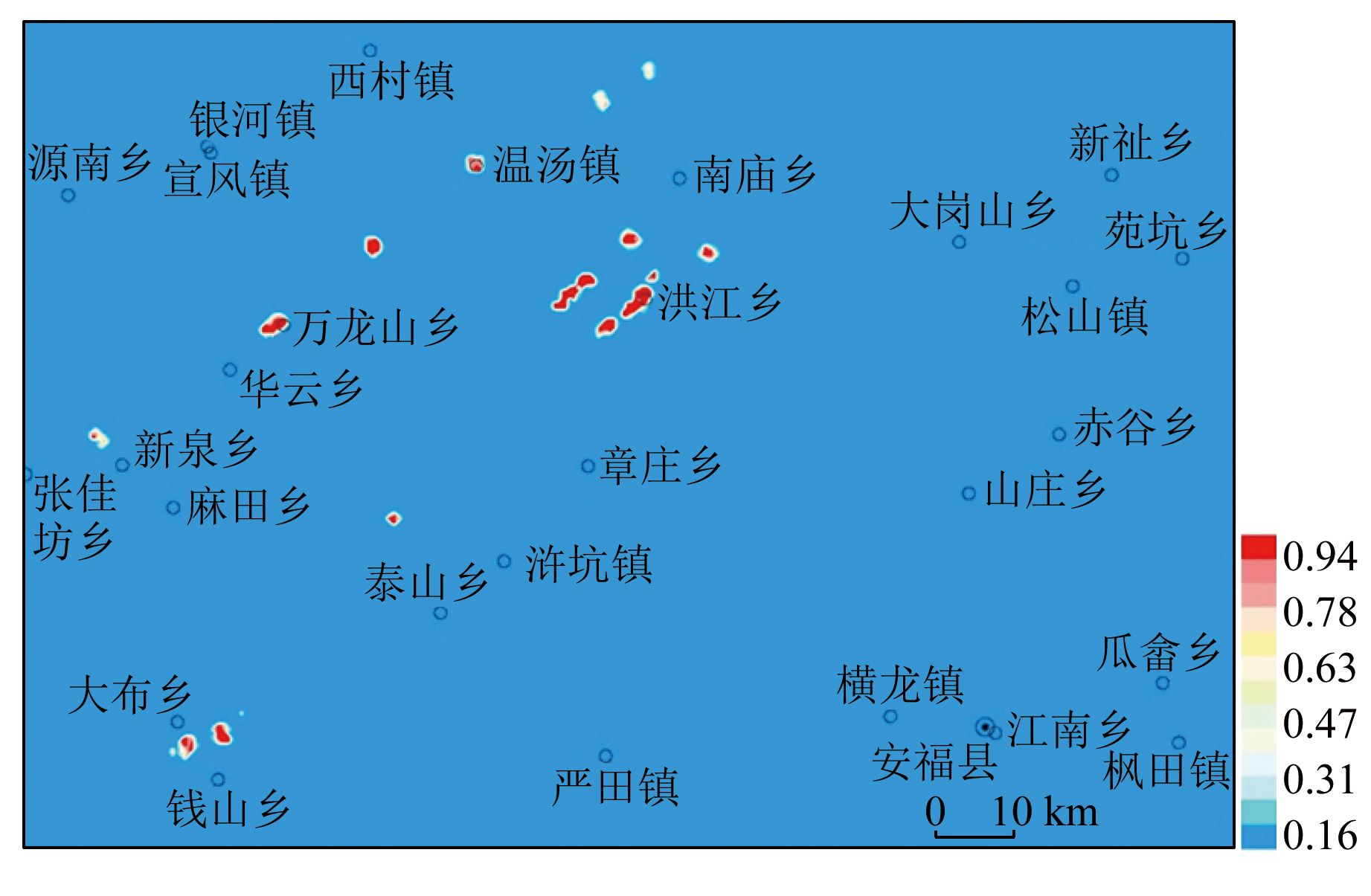
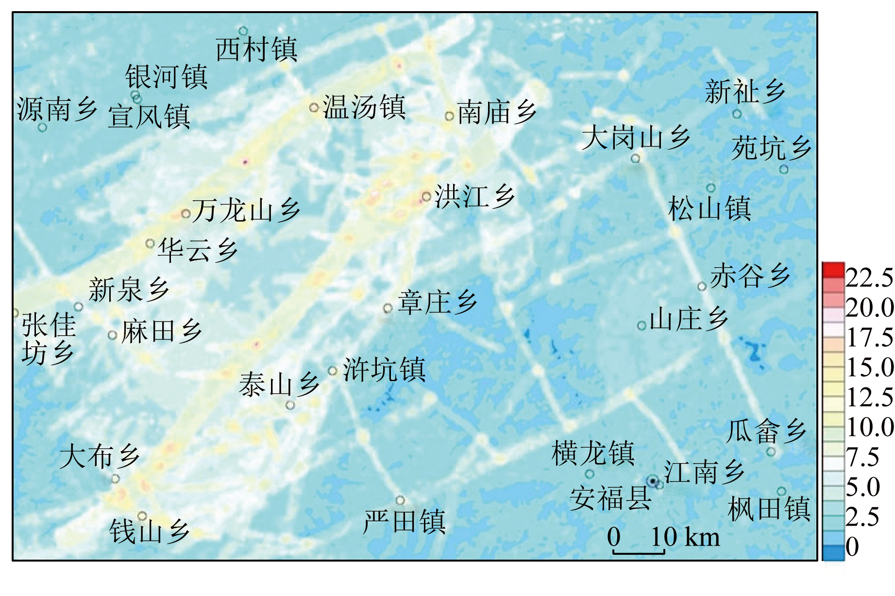
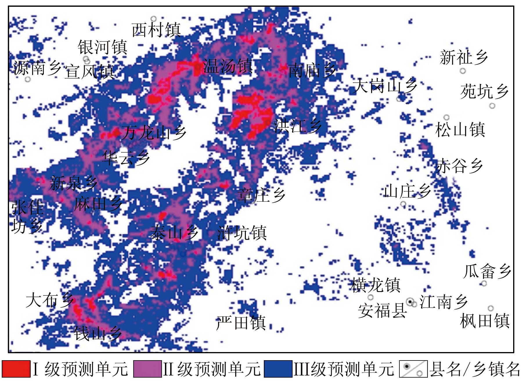
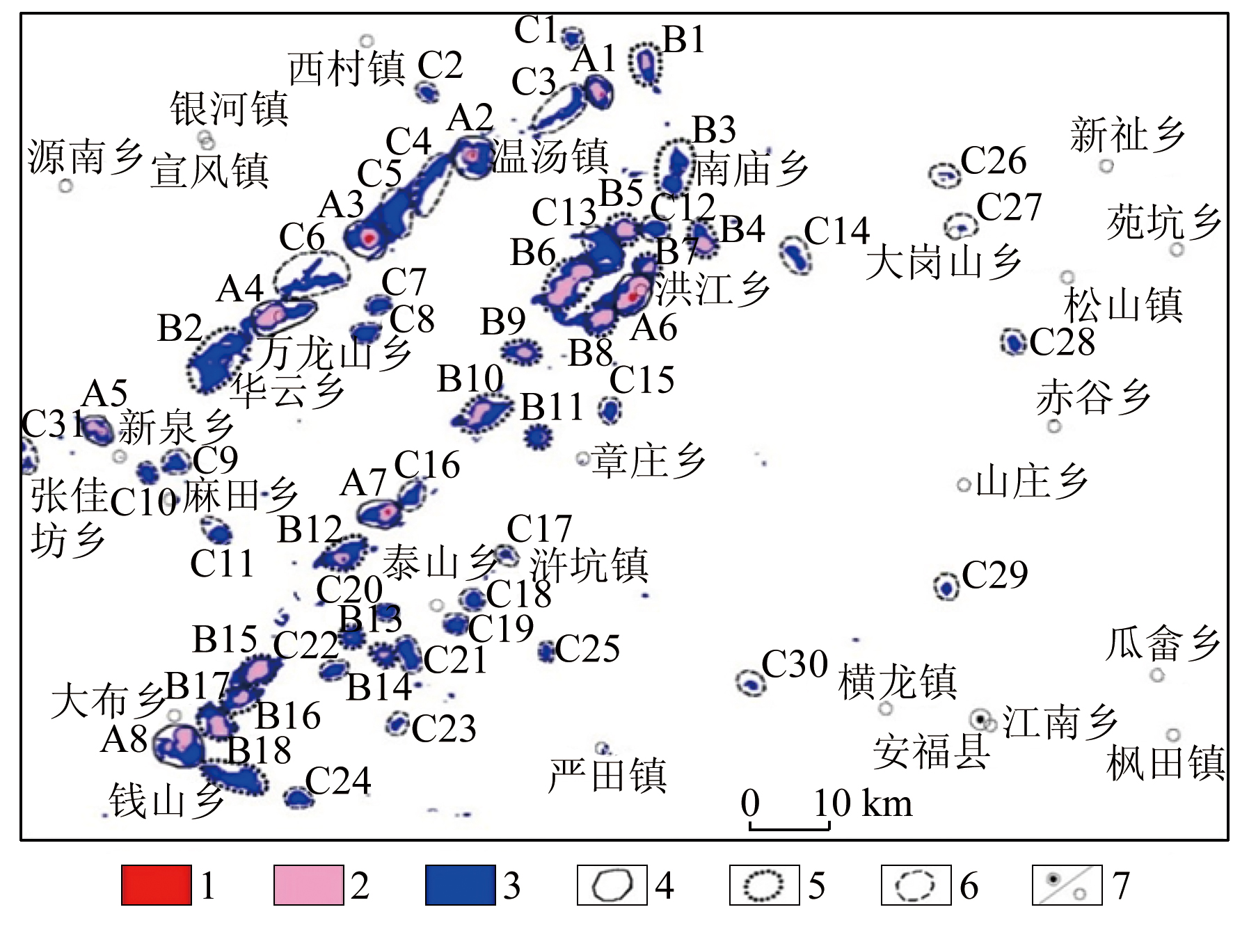
Abstract Based on thermal infrared and multispectral remote sensing data, this study analyzed the thermal spring-related structures interpreted from remote sensing images. Thermal springs crop out at the intersections of asterisk- and lambda-shaped structures, with asterisk-shaped structures exhibiting more favorable conditions. By delving into remote sensing characteristics related to thermal springs, this study presented remote sensing factors like surface temperature, hydroxyl anomaly, soil moisture, hydrographic net, and elevation. Using mathematical geostatistics and prediction methods based on geographical information system (GIS), including the weight of evidence, prospecting information content method, and feature factor method, this study analyzed the geological, remote sensing, and geophysical factors related to thermal springs for mathematical geostatistics and prediction. The comprehensive analysis reveals 57 favorable geothermal areas, including 8 in category A, 18 in category B, and 31 in category C. All the category-A favorable geothermal areas include known geothermal sites, and one category-B favorable area reveals a 51.6 ℃ thermal spring, suggesting reliable prediction results. The methodology of this study provides a new approach for geothermal resource prediction.
|
| Keywords
surface temperature
hydroxyl anomaly
soil moisture
GIS
mathematical geostatistics
|
|
|
|
Issue Date: 14 June 2024
|
|
|
| [1] |
杨俊颖, 温夏伟, 谭红兵. 西藏尼木地区遥感数据地温反演与地热异常预测[J]. 地质论评, 2021, 67(6):1770-1779.
|
| [1] |
Yang J Y, Wen X W, Tan H B. Land surface temperature using remote sensing data inversion and prediction of geothermal anomaly area in Nimu,Xizang(Tibet)[J]. Geological Review, 2021, 67(6):1770-1779.
|
| [2] |
熊永柱, 陈峰, 黄少鹏. 基于遥感技术的腾冲地热异常区识别[J]. 成都理工大学学报(自然科学版), 2016, 43(1):109-118.
|
| [2] |
Xiong Y Z, Chen F, Huang S P. Application of remote sensing technique to the identification of geothermal anomaly in Tengchong area,southwest China[J]. Journal of Chengdu University of Technology(Science &Technology Edition), 2016, 43(1):109-118.
|
| [3] |
辛磊, 刘新星, 张斌. 遥感影像地表温度反演与地热资源预测——以石家庄地区为例[J]. 地质力学学报, 2021, 27(1):40-51.
|
| [3] |
Xin L, Liu X X, Zhang B. Land surface temperature retrieval and geothermal resources prediction by remote sensing image:A case study in the Shijiazhuang area,Hebei Province[J]. Journal of Geomechanics, 2021, 27(1) :40-51.
|
| [4] |
贺金鑫, 孙焕朝, 李文庆, 等. 基于热红外遥感数据辽东地热区地表温度反演[J]. 吉林大学学报(信息科学版), 2018, 36(1):62-68.
|
| [4] |
He J X, Sun H Z, Li W Q, et al. Land surface temperature retrieval in eastern Liaoning geothermal area based on thermal infrared remote sensing data[J]. Journal of Jilin University(Information Science Edition), 2018, 36(1):62-68.
|
| [5] |
孙焕朝. 丹东—辽阳热红外遥感地温反演与地热资源探测方法研究[D]. 长春: 吉林大学, 2018.
|
| [5] |
Sun H Z. Land surface temperature retrieval based on thermal infrared remote sensing data and research on the exploring methodology of geothermal resources in Dandong-Liaoyang[D]. Changchun: Jilin University, 2018.
|
| [6] |
刘效才, 江泳, 刘孝阳, 等. Landsat ETM+遥感数据在寻找临沂地热中的应用[J]. 山东国土资源, 2015, 31(5):76-81.
|
| [6] |
Liu X C, Jiang Y, Liu X Y, et al. Application of Landsat ETM+ remote sensing data in searching geothermal field Linyi City[J]. Shangdong Land Resources, 2015, 31(5):76-81.
|
| [7] |
闫佰忠, 邱淑伟, 肖长来, 等. 长白山玄武岩区地热异常区遥感识别[J]. 吉林大学学报(地球科学版), 2017, 47(6):1819-1828.
|
| [7] |
Yan B Z, Qiu S W, Xiao C L, et al. potential geothermal fields remote sensing identification in Changbai Mountain Basalt area[J]. Journal of Jilin University(Earth Science Edition), 2017, 47(6):1819-1828.
|
| [8] |
张福坤. 长白山地区地热资源潜力预测遥感研究[D]. 长春: 吉林大学, 2016.
|
| [8] |
Zhang F K. Remote prediction of geothermal resource potential in the Changbai Mountain area[D]. Changchun: Jilin University, 2016.
|
| [9] |
张延军, 余海, 李建明, 等. 深部水热型地热潜力区的GIS预测模型——以土耳其西安纳托利亚地区为例[J]. 吉林大学学报(地球科学版), 2016, 46(3):855-864.
|
| [9] |
Zhang Y J, Yu H, Li J M, et al. Prediction models of deep hydrothermal geothermal potential areas based on GIS:A case study of western Anatolia,Turkey[J]. Journal of Jilin University(Information Science Edition), 2016, 46(3):855-864.
|
| [10] |
刘凯, 张垚垚, 何庆成. 圆屋顶下的明珠——环武功山温泉链[J]. 知识就是力量, 2020(10):66-69.
|
| [10] |
Liu K, Zhang Y Y, He Q C, The pearl under the dome——Hot spring chain around Wugong Mountain[J]. Knowledge is Power, 2020(10):66-69.
|
| [11] |
王淼林. 江西省武功山地区地热水控制因素及勘查方向探讨[J]. 科技创新导报, 2018, 15(36):39-40.
|
| [11] |
Wang M L. Controlling factors of geothermal water in Wugong Mountain area of Jiangxi Province and exploration direction[J]. Science and Technology Innovation Herald, 2018, 15(36):39-40.
|
| [12] |
李明. 热红外遥感在福建滨海地热调查中的应用研究[J]. 福建地质, 2016, 35(4):312-318.
|
| [12] |
Li M. Application of thermal infrared remote sensing in Fujian coastal geothermal survey[J]. Geology of Fujian, 2016, 35(4):312-318.
|
| [13] |
陈喆, 董庆, 陈建平, 等. 基于热红外遥感的川藏铁路昌都—林芝段地热异常区定量预测评价研究[J]. 遥感技术与应用, 2021, 36(6):1368-1378.
|
| [13] |
Chen Z, Dong Q, Chen J P, et al. Research on quantitative prediction and evaluation of geothermal anomaly area in Qamdo-Nyingchi section of Sichuan-Tibet railway[J]. Remote Sensing Technology and Application, 2021, 36(6):1368-1378.
|
| [14] |
翟锡丹. 长白山地区地表温度异常遥感研究[D]. 长春: 吉林大学, 2015.
|
| [14] |
Zhai X D. Changbai Mountain Area surgace temperature anomaly of remote sensing research[D]. Changchun: Journal of Jilin University, 2015.
|
| [15] |
毛克彪, 唐华俊, 陈仲新, 等. 一个从 ASTER数据中反演地表温度的劈窗算法[J]. 遥感信息, 2006, 21(5):7-11.
|
| [15] |
Mao K B, Tang H J, Chen Z X, et al. A Split-window algorithm for retrieving land-surface temperature from ASTER data[J]. Remote Sensing Information, 2006, 21(5):7-11.
|
| [16] |
毛克彪, 施建成, 覃志豪, 等. 一个针对 ASTER数据同时反演地表温度和比辐射率的四通道算法[J]. 遥感学报, 2006, 10(4):593-599.
|
| [16] |
Mao K B, Shi J C, Qin Z H, et al. A four-channel algorithm for retrieving land surface temperature and em issivity from ASTER data[J]. Journal of Remote Sensing, 2006, 10(4):593-599.
|
| [17] |
孙静, 赵萍, 叶琦. 一种ASTER数据地表温度反演的劈窗算法[J]. 遥感技术与应用, 2012, 27(5) :728-734.
|
| [17] |
Sun J, Zhao P, Ye Q. A split-window algorithm for retrieving land surface temperature from ASTER data[J]. Remote Sensing Technology and Application, 2012, 27(5) :728-734.
|
| [18] |
高懋芳, 覃志豪. 中国 MODIS地表温度产品验证[J]. 国土资源遥感, 2006, 18(3):15-18.doi:10.6046/gtzyyg.2006.03.04.
|
| [18] |
Gao M F, Qin Z H. The validation of chinese land surface temperature products retrieved from moderate resolution imaging spectroratiometer[J]. Remote Sensing for Land and Resources, 2006, 18(3):15-18.doi:10.6046/gtzyyg.2006.03.04.
|
| [19] |
孙园红. 盲区寻找地下热水零的突破-万龙山地热[J]. 低碳世界, 2018(11):125-126.
|
| [19] |
Sun Y H. Blind zone search for underground hot water zero breakthrough-Wanlongshan geothermal[J]. Low-carbon World, 2018(11):125-126.
|
| [20] |
王淼林. 江西省芦溪县新泉地热地质特征与勘查方向浅析[J]. 中国科技纵横, 2018(20):136-137.
|
| [20] |
Wang M L. Analysis on geothermal geological characteristics and exploration direction of Xinquan in Luxi County,Jiangxi Province[J]. Chinese Science and Technology, 2018(20):136-137.
|
| [21] |
辛田军. 江西省温汤地热田地热水成因机理及开发利用前景[D]. 南京: 南京大学, 2016.
|
| [21] |
Xin T J. Wentang geothermal field and water reaources formation machanism and utilization prospect research in Jiangxi Province[D]. Nanjing: Nanjing University, 2016.
|
| [22] |
霍艾迪, 张广军, 赵君, 等. 基于MODIS数据的沙漠化地区地下水位遥感监测模型的建立——以毛乌素沙地为例[J]. 干旱地区农业研究, 2010, 28(6):196-200.
|
| [22] |
Hui A D, Zhang G J, Zhao J, et al. Study on remote sensing monitoring model of groundwater level in Aeolian desertification areas:A case study of Mu Us Aeolian desertification areas,China[J]. Agricultural Research in the Arid Areas, 2010, 28(6):196-200.
|
| [23] |
罗浩, 王红, 施长惠. 黄河三角洲地区地下水埋深遥感反演[J]. 国土资源遥感, 2013, 25(3):145-152.doi:10.6046/gtzyyg.2013.03.24.
|
| [23] |
Luo H, Wang H, Shi C H. Retrieving groundwater in Yellow River Delta area using remote sensing[J]. Remote Sensing for Land and Resources, 2013, 25(3):145-152.doi:10.6046/gtzyyg.2013.03.24.
|
| [24] |
杨树聪, 沈彦俊, 郭英, 等. 基于表观热惯量的土壤水分监测[J]. 中国生态农业学报, 2011, 19(5):1157-1161.
|
| [24] |
Yang S C, Shen Y J, Guo Y, et al. Monitoring soil moisture by apparent thermal inertia method[J]. Chinese Journal of Eco-Agriculture, 2011, 19(5):1157-1161.
|
| [25] |
吴迪. 土壤湿度指数预测沈阳市浅层地下水[J]. 水利规划与设计, 2018, 12(12):50-53.
|
| [25] |
Wu D. Prediction of shallow groundwater in Shenyang City by soil moisture index[J]. Water Resources Planning and Design, 2018, 12(12):50-53.
|
| [26] |
赵鑫, 王萍, 马力. 基于遥感数据的矿区土壤湿度信息提取及影响因素分析[J]. 中国科技论文, 2019, 14(9):991-997.
|
| [26] |
Zhao X, Wang P, Ma L. Extraction of soil moisture information based on remote sensing data and analysis of influencing factors[J]. China Sciencepaper, 2019, 14(9):991-997.
|
| [27] |
刘英, 吴立新, 马保东. 基于TM/ETM+ 光谱特征空间的土壤湿度遥感监测[J]. 中国矿业大学学报, 2013, 42(2):296-301.
|
| [27] |
Liu Y, Wu L X, Ma B D. Remote sensing monitoring of soil moisture on the basis of TM/ETM+ spectral space[J]. Journal of China University of Mining and Technology, 2013, 42(2):296-301.
|
| [28] |
杨建民, 张玉君, 陈薇, 等. 矿产资源调查评价的现代化技术方法——以ETM+蚀变遥感异常为主导的多元信息矿产评价方法[J]. 矿床地质, 2002, 21(s1):1225-1227.
|
| [28] |
Yang J M, Zhang Y J, Chen W, et al. Application for technigue in abstracting:Remote alteration anomalies from ETM+(TM) data in eastern Tianshan,Xinjiang,China[J]. Mineral Deposits, 2002, 21(s1):1225-1227.
|
| [29] |
杨建民, 张玉君, 陈薇, 等. ETM+(TM)蚀变遥感异常技术方法在东天山戈壁地区的应用[J]. 矿床地质, 2003, 22(3):278-286.
|
| [29] |
Yang J M, Zhang Y J, Chen W, et al. Application of ETM+(TM) remote sensing alteration anomaly extraction technique to Gobi Area,East Tianshan mountains[J]. Mineral Deposits, 2003, 22(3):278-286.
|
| [30] |
张玉君, 姚佛军. 应用多光谱ASTER数据对ETM遥感异常的定性判别研究——以东昆仑五龙沟为例[J]. 岩石学报, 2009, 25(4):963-970.
|
| [30] |
Zhang Y J, Yao F J. Application study of multi-spectral ASTER data for determination of ETM remote sensing anomaly property:Taking Wulonggou region of eastern KumLun moutain range as example[J]. Acta Mineralogica Sinica, 2015, 25(4):963-970.
|
| [31] |
张玉君, 曾朝铭, 陈薇. ETM+(TM)蚀变遥感异常提取方法研究与应用——方法选择和技术流程[J]. 国土资源遥感, 2003, 15(2) :44-50.doi:10.6046/gtzyyg.2003.02.11.
|
| [31] |
Zhang Y J, Zeng Z M, Chen W. The methods for extraction of alteration anomalies from the ETM+(TM) data and their application:Method selection and technological flow chart[J]. Remote Sensing for Land and Resources, 2003, 15(2) :44-50.doi:10.6046/gtzyyg.2003.02.11.
|
| [32] |
张玉君, 曾朝铭, 姚佛军. 利用光谱角填图(SAM)优化多光谱遥感异常[J]. 矿物学报, 2015, 35(s1):985.
|
| [32] |
Zhang Y J, Zeng Z M, Yao F J. Optimization of multispectral remote sensing anomaliy by spectral angle mapping(SAM)[J]. Acta Mineralogica Sinica, 2015, 35(s1):985.
|
| [33] |
孔辉, 孙增慧, 石磊, 等. 在ArcGIS软件下利用DEM数据提取流域水系网[J]. 数字技术与应用, 2018, 36(9):76-78.
|
| [33] |
Kong H, Sun Z H, Shi L, et al. Extracting watershed network from DEM data under ArcGIS software[J]. Digital Technology and Application, 2018, 36(9):76-78.
|
| [34] |
罗大游, 温兴平, 沈攀, 等. 基于DEM的水系提取及集水阈值确定方法研究[J]. 水土保持通报, 2017, 37(4):189-193.
|
| [34] |
Luo D Y, Wen X P, Shen P, et al. Information extraction of river networks and determination of drainage area threshold using DEM data[J]. Bulletion of Soil and Water Conservation, 2017, 37(4):189-193.
|
| [35] |
吴恩政. 基于GIS的证据权法在矿产资源评价中的应用[D]. 北京: 中国地质大学(北京), 2014.
|
| [35] |
Wu E Z. Application of evidence weight method based on GIS in mineral resource evaluation[D]. Beijing: China University of Geosciences (Beijing), 2014.
|
| [36] |
雷天赐, 罗士新, 王磊. 基于多元信息的证据权法在南岭钨锡多金属成矿预测中的应用[J]. 华南地质与矿产, 2016, 32(1):34-42.
|
| [36] |
Lei T C, Luo S X, Wang L. Application of weights of evidence method for prediction of W-Sn polymetallic deposits based on multi -source information in Nanling metallogenic belt[J]. Geology and Mineral Resources of South China, 2016, 32(1):34-42.
|
| [37] |
方捷, 张晓东, 张定源, 等. 基于证据权法的安徽东溪金矿大比例尺成矿预测与评价[J]. 华东地质, 2017, 38(1):37-44.
|
| [37] |
Fang J, Zhang X D, Zhang D Y, et al. Prediction and evaluation of large scale metallogeny in the Dongxi gold deposit of Anhui Province based on the weights of evidence methodology[J]. East China Geology, 2017, 38(1):37-44.
|
| [38] |
刘亚洲, 申维. 基于GIS的证据权法在铁力-二股地区铅锌多金属矿床预测中的应用[J]. 地质与勘探, 2018, 54(1):59-68.
|
| [38] |
Liu Y Z, Shen W. Application of the evidence - weight method based on GIS to the prediction of the lead - zinc polymetallic deposit in the Tieli - Ergu area[J]. Geology and Exploration, 2018, 54(1):59-68.
|
| [39] |
浦路平, 朱国器, 尹意求, 等. 与找矿信息量法结合的含矿网格单元蒙特卡洛矿产资源潜力评价方法的原理及应用[J]. 矿产与地质, 2016, 30(3):490-495.
|
| [39] |
Pu L p, Zhu G Q, Yin Y Q, et al. Principles and application of ore-bearing-grid-cell based Monte-Carlo method for mineral resource potetial assessment combined with prospecting information method[J]. Mineral Resources and Geology, 2016, 30(3):490-495.
|
| [40] |
吴传军, 许德如, 周迎春, 等. 基于特征分析法的琼南矽卡岩型矿床成矿预测研究[J]. 大地构造与成矿学, 2015, 39(3):528-541.
|
| [40] |
Wu C J, Xu D R, Zhou Y C, et al. Metallogenic prognosis for skarn-type deposits based on characteristic analysis in southern Hainan Island[J]. Geotectonica et Metallogenia, 2015, 39(3):528-541.
|
|
Viewed |
|
|
|
Full text
|
|
|
|
|
Abstract
|
|
|
|
|
Cited |
|
|
|
|
| |
Shared |
|
|
|
|
| |
Discussed |
|
|
|
|
 2024,
Vol. 36
2024,
Vol. 36