Please wait a minute...
 
Remote Sensing for Natural Resources    2025, Vol. 37 Issue (5) : 206-215     DOI: 10.6046/zrzyyg.2024298
|
Reconstruction of vegetation index time-series data for crops at a 15 m resolution after reflectance normalization of multi-satellite data
AO Yangqian1,2(), SUN Liang1()
1. Institute of Agricultural Resources and Agricultural Zoning,Chinese Academy of Agricultural Sciences/National Key Laboratory for Efficient Utilization of Arid and Semiarid Cultivated Land in the North,Beijing 100081,China
2. Jiangxi Institute of Meteorological Sciences/Key Laboratory of Climate Change Risk and Meteorological Disaster Prevention of Jiangxi Province,Nanchang 330096,China
Download: PDF(4831 KB)   HTML
Export: BibTeX | EndNote | Reference Manager | ProCite | RefWorks    
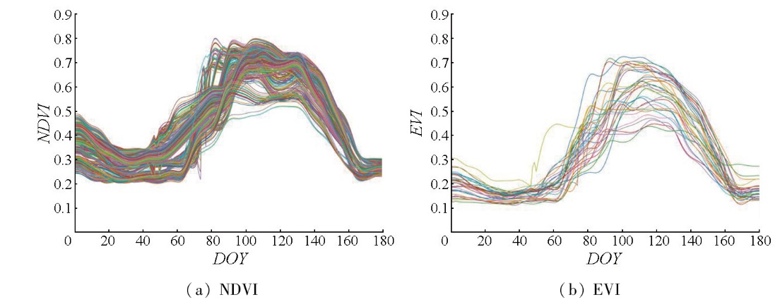
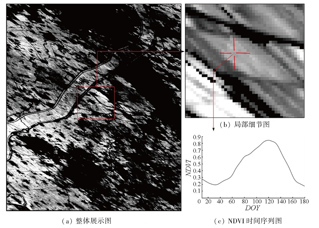
Abstract  

Changes in the vegetation index can reflect variations in vegetation cover and growth in the region to some extent. Monitoring the changes in vegetation index time-series data plays a significant role in local agricultural management. However,existing methods for vegetation index time-series data reconstruction face challenges such as a single data source input and low spatial resolution of reconstruction results. In response to this,this paper proposes a reconstruction method for vegetation index time-series data that integrates the satellite data standardization method and the crop reference curve method. Consequently,it reconstructed vegetation index time-series data with high spatiotemporal resolution for winter wheat in the study area in 2021,including normalized differential vegetation index (NDVI) and enhanced vegetation index (EVI). The results show that after reflectance normalization,the coefficient of determination (R2) for GF-1 satellite and VIIRS surface reflectance data in red,green,infrared,and near infrared bands generally increased by 0.05%,with a few exceeding 0.1%. The root mean square error (RMSE) was reduced,with the majority decreasing by 0.01. In contrast,the relative root mean square error (rRMSE) showed a reduction of about 2%. Most data from the GF-6 satellites exhibited an increase of about 0.12 in R2,a decrease of 0.03 in RMSE,and a general decline in rRMSE ranging from 3% to 4%. In contrast,the data from the Sentinel-2 satellite show an overall increase of about 0.05 in R2,as well as a decrease of around 0.001 and 2% in RMSE and rRMSE,respectively. The accuracy assessment results for the reconstructed high-resolution vegetation index time-series data indicate that the NDVI time-series reconstruction results presented high R2 values in the validation period,with five validation images reaching 0.49 and above. The RMSE was less than 0.1 in all validation periods,while the relative error (RE) was less than 15% in most cases,with only one validation image reaching 18%. Similarly,the EVI time-series reconstruction results also exhibited high R2 values,with five validation images above 0.44. Both RMSE and rRMSE values were less than 0.15 and 20%,respectively.

Keywords crop reference curve      reflectance normalization      vegetation index      time series      data reconstruction     
ZTFLH:  TP79  
Issue Date: 28 October 2025
Service
E-mail this article
E-mail Alert
RSS
Articles by authors
Yangqian AO
Liang SUN
Cite this article:   
Yangqian AO,Liang SUN. Reconstruction of vegetation index time-series data for crops at a 15 m resolution after reflectance normalization of multi-satellite data[J]. Remote Sensing for Natural Resources, 2025, 37(5): 206-215.
URL:  
https://www.gtzyyg.com/EN/10.6046/zrzyyg.2024298     OR     https://www.gtzyyg.com/EN/Y2025/V37/I5/206
Fig.1  Sentinel-2 image of research area
数据类型 名称 时间 空间分辨率/m
卫星反射
率数据
GF-1 2021-01-03 16
2021-01-28
2021-02-17
2021-04-07
GF-6 2021-02-16 16
2021-03-04
2021-04-18
2021-05-01
2021-05-05
Sentinel-2 2021-02-01 10
2021-02-11
2021-03-03
2021-03-23
2021-04-27
2021-05-07
2021-05-27
2021-06-26
VIIRS数据 VNP09GA 2021年1—6月 1 000
作物分
布数据
中国冬小麦
识别数据集
2021年 10
Tab.1  Datasheet of this article
Fig.2  Research flowchart
Fig.3  NDVI,EVI curve library
波段 标准化
R2
标准化
R2
标准
化前
RMSE
标准
化后
RMSE
标准
化前
rRMSE/%
标准
化后
rRMSE/%
蓝光 0.568 0.658 0.01 0.008 33.199 29.557
绿光 0.563 0.632 0.012 0.011 17.037 15.624
红光 0.592 0.642 0.017 0.016 28.550 26.732
近红外 0.822 0.861 0.003 0.028 8.020 7.078
Tab.2  Changes in evaluation indicators before and after standardization of GF-1 satellite reflectance
波段 标准化
R2
标准化
R2
标准
化前
RMSE
标准
化后
RMSE
标准
化前
rRMSE/%
标准
化后
rRMSE/%
蓝光 0.499 0.620 0.014 0.011 22.497 18.852
绿光 0.518 0.674 0.018 0.015 16.526 13.591
红光 0.585 0.721 0.029 0.024 23.666 19.423
近红外 0.759 0.812 0.041 0.036 10.421 9.202
Tab.3  Changes in evaluation indicators before and after standardization of GF-6 satellite reflectance
波段 标准化
R2
标准化
R2
标准
化前
RMSE
标准
化后
RMSE
标准
化前
rRMSE/%
标准
化后
rRMSE/%
蓝光 0.326 0.446 0.01 0.009 22.816 20.688
绿光 0.572 0.646 0.012 0.011 16.856 15.335
红光 0.586 0.647 0.017 0.015 28.74 26.552
近红外 0.824 0.864 0.031 0.027 7.976 7.012
Tab.4  Changes in evaluation indicators before and after standardization of Sentinel-2 satellite reflectance
Fig.4  Plot of NDVI time series reconstruction results
Fig.5  EVI time series reconstruction result map
积日 原始NDVI
图像均值
重建NDVI
图像均值
Bias RMSE RE/% R2
28 0.23 0.19 -0.04 0.05 18.25 0.49
42 0.21 0.21 0.00 0.03 11.49 0.52
47 0.26 0.24 -0.02 0.03 9.22 0.85
82 0.55 0.54 -0.01 0.09 14.26 0.38
117 0.67 0.75 0.07 0.10 13.71 0.59
125 0.74 0.73 -0.01 0.04 3.90 0.84
127 0.67 0.73 0.06 0.10 13.07 0.42
Tab.5  NDVI time series reconstruction accuracy evaluation
积日 原始EVI
图像均值
重建EVI
图像均值
Bias RMSE RE/% R2
28 0.15 0.14 -0.004 0.02 11.56 0.49
42 0.15 0.15 -0.005 0.03 13.37 0.44
47 0.14 0.16 0.013 0.02 11.64 0.78
82 0.44 0.48 0.034 0.19 38.95 0.10
117 0.62 0.55 -0.072 0.11 13.63 0.57
125 0.56 0.50 -0.057 0.07 11.16 0.74
127 0.60 0.49 -0.108 0.14 20.59 0.35
Tab.6  EVI time series reconstruction accuracy evaluation
Fig.6  Line graph of NDVI time series before and after standardization
[1] Chen J, Jönsson P, Tamura M, et al. A simple method for reconstructing a high-quality NDVI time-series data set based on the Savitzky-Golay filter[J]. Remote Sensing of Environment, 2004, 91(3/4):332-344.
[2] 边金虎, 李爱农, 宋孟强, 等. MODIS植被指数时间序列Savitzky-Golay滤波算法重构[J]. 遥感学报, 2010, 14(4):725-741.
[2] Bian J H, Li A N, Song M Q, et al. Reconstruction of NDVI time-series datasets of MODIS based on Savitzky-Golay filter[J]. Journal of Remote Sensing, 2010, 14(4):725-741.
[3] 胡顺石, 黄春晓, 杨斌, 等. 自适应加权Savitzky-Golay滤波重构MODIS植被指数时间序列[J]. 测绘科学, 2020, 45(4):105-116.
[3] Hu S S, Huang C X, Yang B, et al. Reconstruction of MODIS vegetation index time series by adaptive weighted Savitzky-Golay filter[J]. Science of Surveying and Mapping, 2020, 45(4):105-116.
[4] Lovell J L, Graetz R D. Filtering pathfinder AVHRR land NDVI data for Australia[J]. International Journal of Remote Sensing, 2001, 22(13):2649-2654.
[5] 王鹏新, 荀兰, 李俐, 等. 基于时间序列叶面积指数傅里叶变换的作物种植区域提取[J]. 农业工程学报, 2017, 33(21):207-215.
[5] Wang P X, Xun L, Li L, et al. Extraction of planting areas of main crops based on Fourier transformed characteristics of time series leaf area index products[J]. Transactions of the Chinese Society of Agricultural Engineering, 2017, 33(21):207-215.
[6] Yang G, Shen H, Zhang L, et al. A moving weighted harmonic analysis method for reconstructing high-quality SPOT vegetation NDVI time-series data[J]. IEEE Transactions on Geoscience and Remote Sensing, 2015, 53(11):6008-6021.
[7] Jonsson P, Eklundh L. Seasonality extraction by function fitting to time-series of satellite sensor data[J]. IEEE Transactions on Geoscience and Remote Sensing, 2002, 40(8):1824-1832.
[8] 邵亚婷, 王卷乐, 严欣荣. 蒙古国植被物候特征及其对地理要素的响应[J]. 地理研究, 2021, 40(11):3029-3045.
doi: 10.11821/dlyj020210139
[8] Shao Y T, Wang J L, Yan X R. The phenological characteristics of Mongolian vegetation and its response to geographical elements[J]. Geographical Research, 2021, 40(11):3029-3045.
[9] Ma M, Veroustraete F. Reconstructing pathfinder AVHRR land NDVI time-series data for the Northwest of China[J]. Advances in Space Research, 2006, 37(4):835-840.
[10] 樊辉. 融合QA-SDS的MODIS NDVI时序数据重构[J]. 遥感技术与应用, 2013, 28(1):90-96.
doi: 10.11873/j.issn.1004-0323.2013.1.90
[10] Fan H. MODIS NDVI time-series data reconstruction integrating with the quality assessment science data set(QA-SDS)[J]. Remote Sensing Technology and Application, 2013, 28(1):90-96.
[11] Sun L, Gao F, Xie D, et al. Reconstructing daily 30 m NDVI over complex agricultural landscapes using a crop reference curve approach[J]. Remote Sensing of Environment, 2021, 253:112156.
[12] Che X, Zhang H K, Liu J. Making Landsat 5,7 and 8 reflectance consistent using MODIS nadir-BRDF adjusted reflectance as reference[J]. Remote Sensing of Environment, 2021, 262:112517.
[13] 贾良良, 刘克桐, 孙彦铭, 等. 河北省低平原区近16年来农田施肥量、作物产量和养分效率的变化特征[J]. 中国土壤与肥料, 2017(3):50-55.
[13] Jia L L, Liu K T, Sun Y M, et al. Dynamic changes of fertilization rate,yield and nutrient use efficiency in recent 16 years in the low plain area of Hebei Province[J]. Soil and Fertilizer Sciences in China, 2017(3):50-55.
[14] 王晓峰, 陈霞. 衡水市冬小麦节水品种栽培技术试验[J]. 种子世界, 2016(5):25-26.
[14] Wang X F, Chen X. Experiment on cultivation techniques of water-saving winter wheat varieties in Hengshui City[J]. Seed World, 2016(5):25-26.
[15] 潘海珠. 基于作物多模型遥感数据同化的区域冬小麦生长模拟研究[D]. 北京: 中国农业科学院, 2020.
[15] Pan H Z. Regional winter wheat growth simulation based on multi-model remote sensing data assimilation[D]. Beijing: Chinese Academy of Agricultural Sciences, 2020.
[16] 吴尚蓉. 基于流依赖背景误差同化系统的冬小麦估产研究[D]. 北京: 中国农业科学院, 2019.
[16] Wu S R. Winter wheat yield estimation based on flow-dependent background error assimilation system[D]. Beijing: Chinese Academy of Agricultural Sciences, 2019.
[17] 闫峰, 史培军, 武建军, 等. 基于MODIS-EVI数据的河北省冬小麦生育期特征[J]. 生态学报, 2008, 28(9):4381-4387.
[17] Yan F, Shi P J, Wu J J, et al. The phenology character of winter wheat by MODIS-EVI data in Hebei China[J]. Acta Ecologica Sinica, 2008, 28(9):4381-4387.
[1] XU Ying, ZHANG Runze, GUO Bing. Spatiotemporal variations of 2000—2020 vegetation in China and their time-lag responses to climate[J]. Remote Sensing for Natural Resources, 2025, 37(5): 254-266.
[2] TANG Wei, YAN Zhuangzhuang, WANG Yiming, XU Fangfang, WU Xuanyu. Land subsidence caused by groundwater level recovery in Taiyuan City[J]. Remote Sensing for Natural Resources, 2025, 37(2): 108-116.
[3] XIE Yijia, YANG Beibei, ZHANG Zhen, CHEN Jia, WANG Zhe, MENG Lingkui. Analysis of the changes in spring phenology of vegetation in Beijing City from 2000 to 2022[J]. Remote Sensing for Natural Resources, 2025, 37(2): 185-193.
[4] CHEN Zhiyang, MAO Dehua, WANG Zongming, LIN Nan, JIA Mingming, REN Chunying, WANG Ming. Information extraction of aquaculture ponds in the Jianghan Plain based on Sentinel-2 time-series data[J]. Remote Sensing for Natural Resources, 2025, 37(1): 169-178.
[5] CHEN Yuanyuan, YAN Shuoting, YAN Jin, ZHENG Siqi, WANG Hao, ZHU Jie. Forest disturbance monitoring in Lishui City, China based on Landsat time series images and the LandTrendr algorithm[J]. Remote Sensing for Natural Resources, 2025, 37(1): 179-187.
[6] YU Wenxuan, LI Yimin, JI Peikun, FENG Xianjie, XIANG Qianying. Time series surface deformation of the upper reaches of Huangdeng hydropower station in Lanping County based on ascending and descending SAR data[J]. Remote Sensing for Natural Resources, 2024, 36(4): 282-294.
[7] LING Xiaolu, CHEN Chaorong, GUO Weidong, QIN Kai, ZHANG Jinlong. Comprehensive evaluation of ESA CCI soil moisture data in eastern China[J]. Remote Sensing for Natural Resources, 2024, 36(4): 92-106.
[8] LUO Wei, LI Xiuhua, QIN Huojuan, ZHANG Muqing, WANG Zeping, JIANG Zhuhui. Identification and yield prediction of sugarcane in the south-central part of Guangxi Zhuang Autonomous Region, China based on multi-source satellite-based remote sensing images[J]. Remote Sensing for Natural Resources, 2024, 36(3): 248-258.
[9] MING Xiaoyong, TIAN Yichao, ZHANG Qiang, TAO Jin, ZHANG Yali, LIN Junliang. Monitoring and analyzing land subsidence in Qinfang, Guangxi based on Sentinel-1A data[J]. Remote Sensing for Natural Resources, 2024, 36(1): 35-48.
[10] YI Bangjin, HUANG Cheng, FU Tao, SUN Jixing, ZHU Baoquan, ZHONG Cheng. SBAS-InSAR-based detection of geological hazards in alpine gorge areas near the China-Myanmar border[J]. Remote Sensing for Natural Resources, 2023, 35(4): 186-191.
[11] ZHANG Zhimei, FAN Yanguo, JIAO Zhijun, GUAN Qingchun. Impact of soil salinization on the eco-environment quality of coastal wetlands:A case study of Yellow River Delta[J]. Remote Sensing for Natural Resources, 2023, 35(4): 226-235.
[12] QIN Le, HE Peng, MA Yuzhong, LIU Jianqiang, YANG Bin. Change detection of satellite time series images based on spatial-temporal-spectral features[J]. Remote Sensing for Natural Resources, 2022, 34(4): 105-112.
[13] YU Wen, GONG Huili, CHEN Beibei, ZHOU Chaofan. Spatial-temporal evolution characteristics and prediction of land subsidence in the eastern plain of Beijing[J]. Remote Sensing for Natural Resources, 2022, 34(4): 183-193.
[14] MAO Kebiao, YAN Yibo, CAO Mengmeng, YUAN Zijin, QIN Zhihao. Reconstruction of surface temperature data and analysis of spatial and temporal changes in North America[J]. Remote Sensing for Natural Resources, 2022, 34(4): 203-215.
[15] DONG Jihong, MA Zhigang, LIANG Jingtao, LIU Bin, ZHAO Cong, ZENG Shuai, YAN Shengwu, MA Xiaobo. A comparative study of the identification of hidden landslide hazards based on time series InSAR techniques[J]. Remote Sensing for Natural Resources, 2022, 34(3): 73-81.
Viewed
Full text


Abstract

Cited

  Shared   
  Discussed   
京ICP备05055290号-2
Copyright © 2017 Remote Sensing for Natural Resources
Support by Beijing Magtech