|
|
 |
|

|
|
|
SBAS-InSAR-based detection of geological hazards in alpine gorge areas near the China-Myanmar border |
YI Bangjin1( ), HUANG Cheng2, FU Tao1, SUN Jixing1, ZHU Baoquan1, ZHONG Cheng3() ), HUANG Cheng2, FU Tao1, SUN Jixing1, ZHU Baoquan1, ZHONG Cheng3() |
1. Yunnan Institute of Geological Science, Kuming 650051, China
2. Yunnan Institute of Geological Environment Monitoring Institute, Kuming 650216, China
3. Badong National Observation and Research Station of Geohazards, China University of Geosciences, Wuhan, Wuhan 430079, China |
|
|
|
|
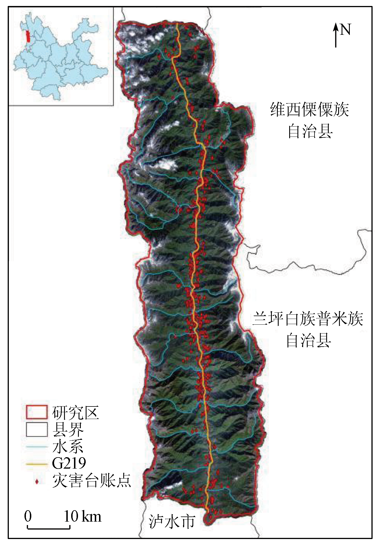
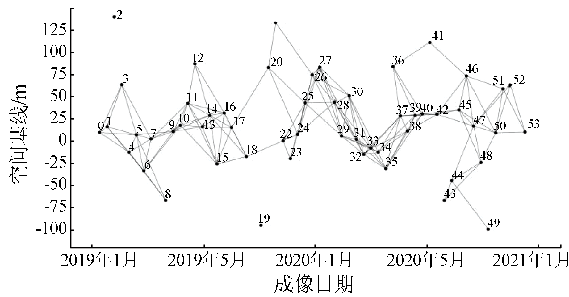
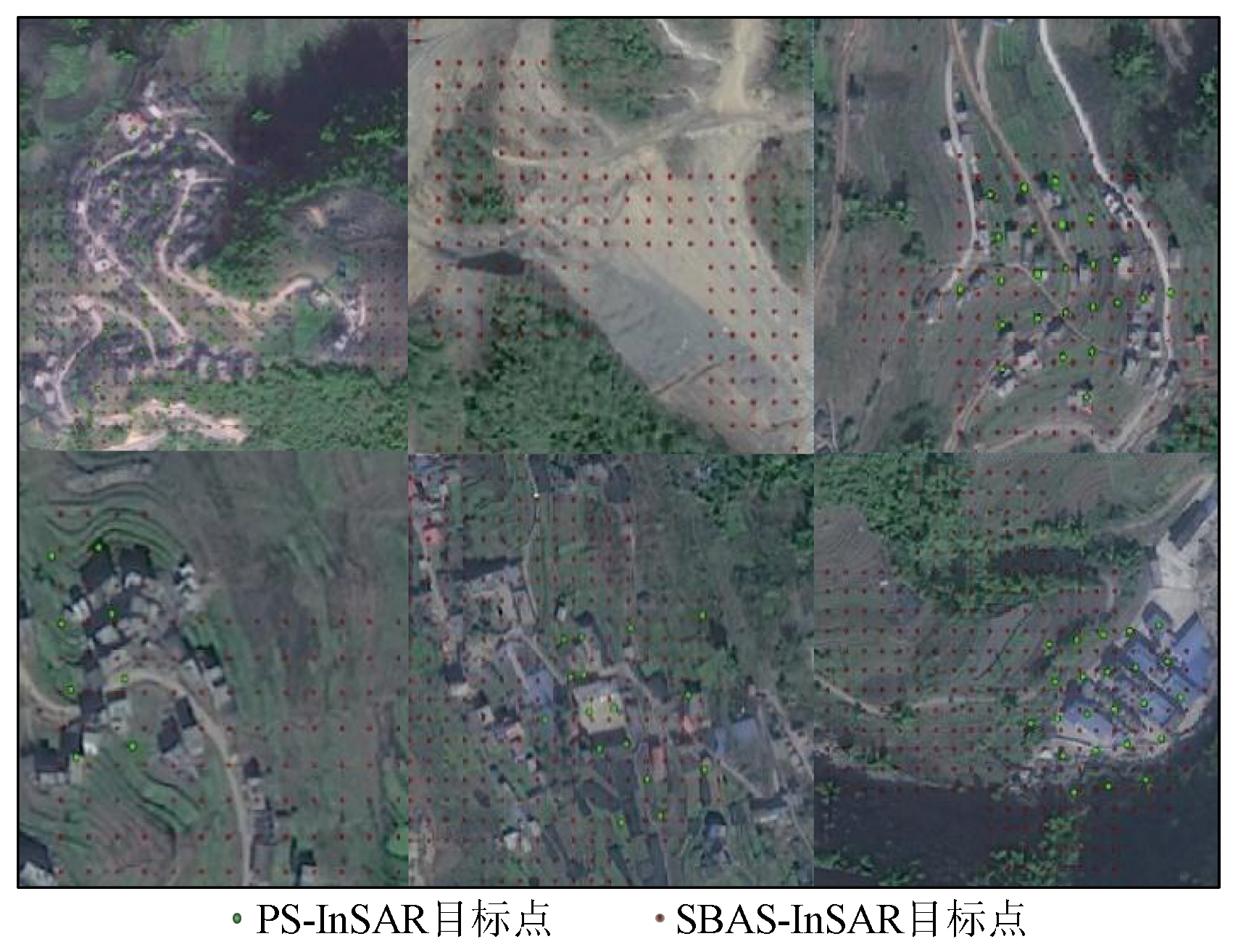
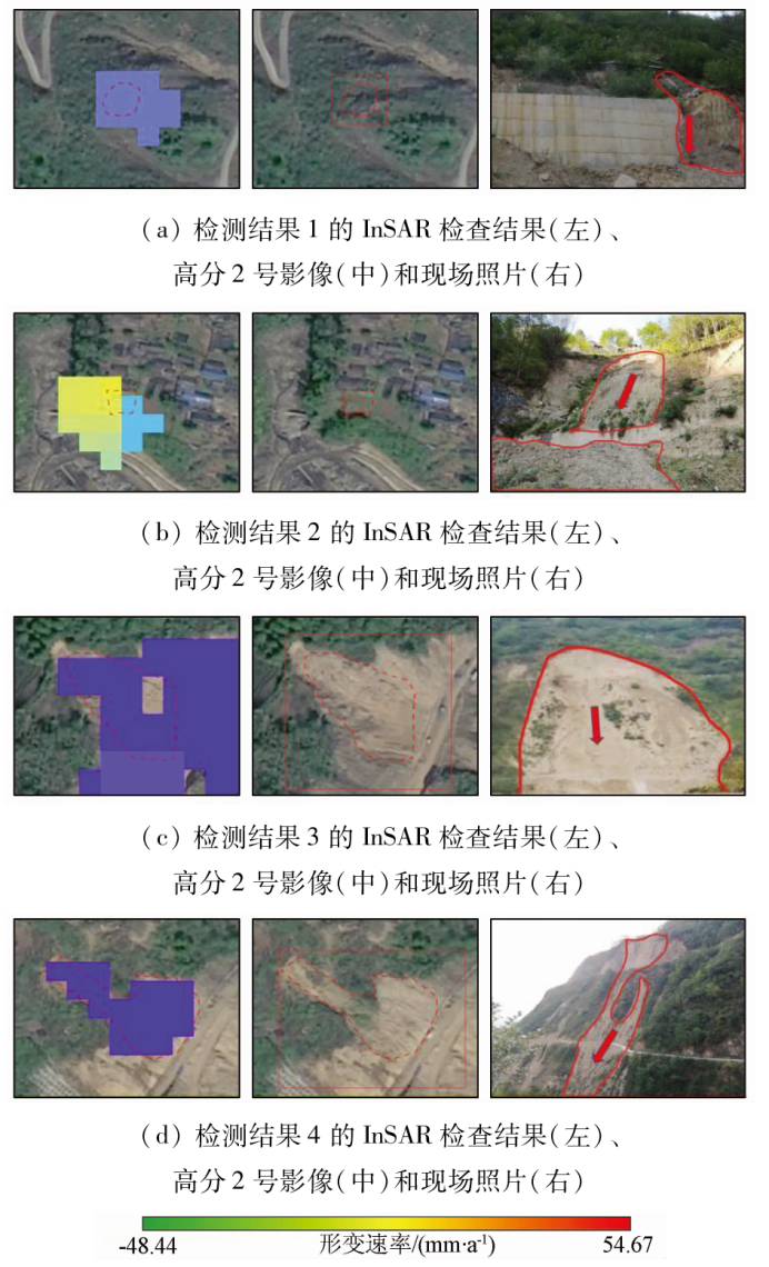
Abstract Fugong County of Yunnan Province, located near the Yunnan-Myanmar border, is a typical alpine gorge area with a fragile geological environment. Geological hazards, including landslide, collapse, and debris flow, occur frequently in this area, thus posing a severe threat to the safety of people's lives and properties, economic development, and even national defense security. However, high mountains and thick forests in this area complicate manual investigations and increase the risk. Hence, this study conducted surface deformation monitoring and geological hazard detection in this alpine gorge area by employing the small baseline subset - interferometric synthetic aperture radar (SBAS-InSAR) technology based on the Sentinel-1A satellite data. The identification results were verified by combining ground surveys and the interpretation of optical remote sensing images. The findings indicate that most of the deformation zones in this area exhibit fragile geological conditions and are prone to landslide instability in the case of heavy rainfall, thus requiring continuous observation. This study offers a valuable reference for investigating and monitoring landslides in alpine gorge areas.
|
| Keywords
geological hazard
time series
InSAR
hazard detection
alpine gorge
|
|
|
|
Issue Date: 21 December 2023
|
|
|
| [1] |
张培震, 邓起东, 张竹琪, 等. 中国大陆的活动断裂、地震灾害及其动力过程[J]. 中国科学:地球科学, 2013, 43(10):1607-1620.
|
| [1] |
Zhang P Z, Deng Q D, Zhang Z Q, et al. Active faults,earthquake disasters and their dynamic processes in Chinese mainland[J]. Scientia Sinica Terrae, 2013, 43(10):1607-1620.
doi: 10.1360/zd-2013-43-10-1607
url: http://engine.scichina.com/doi/10.1360/zd-2013-43-10-1607
|
| [2] |
刘传正, 陈春利. 中国地质灾害防治成效与问题对策[J]. 工程地质学报, 2020, 28(2),375-383.
|
| [2] |
Liu C Z, Chen C L. Achievements and countermeasures in risk reduction of geological disasters in China[J]. Journal of Engineering Geology, 2020, 28(2),375-383.
|
| [3] |
许强, 董秀军, 李为乐. 基于天-空-地一体化的重大地质灾害隐患早期识别与监测预警[J]. 武汉大学学报(信息科学版), 2019, 44(7):957-966.
|
| [3] |
Xu Q, Dong X J, Li W L. Integrated space-air-ground early detection,monitoring and warning system for potential catastrophic geohazards[J]. Geomatics and Information Science of Wuhan University, 2019, 44(7),957-966.
|
| [4] |
廖明生, 王腾. 时间序列InSAR技术与应用[M]. 北京: 科学出版社, 2014.
|
| [4] |
Liao M S, Wang T. Time series InSAR technology and its application[M]. Beijing: Science Press, 2014.
|
| [5] |
廖明生, 张路, 史绪国, 等. 滑坡变形雷达遥感监测方法与实践[M]. 北京: 科学出版社, 2017.
|
| [5] |
Liao M S, Zhang L, Shi X G, et al. Remote sensing monitoring method and practice of landslide deformation radar[M]. Beijing: Science Press, 2017.
|
| [6] |
Crosetto M, Monserrat O, Cuevas-González M, et al. Persistent scatterer interferometry:A review[J]. ISPRS Journal of Photogrammetry and Remote Sensing, 2016, 115:78-89.
doi: 10.1016/j.isprsjprs.2015.10.011
url: https://linkinghub.elsevier.com/retrieve/pii/S0924271615002415
|
| [7] |
付波霖, 解淑毓, 李涛, 等. 基于SBAS/PS-InSAR技术的滑坡遥感监测对比研究[J]. 大地测量与地球动力学, 2021, 41(4):392-398.
|
| [7] |
Fu B L, Xie S Y, Li T, et al. Comparative study of landslide remote sensing monitoring based on SBAS/PS-InSAR technology[J]. Journal of Geodesy and Geodynamics, 2021, 41(4):392-398.
|
| [8] |
杨成生, 董继红, 朱赛楠, 等. 金沙江结合带巴塘段滑坡群InSAR探测识别与形变特征[J]. 地球科学与环境学报, 2021, 43(2):398-408.
|
| [8] |
Yang C S, Dong J H, Zhu S N, et al. Detection,identification and deformation characteristics of landslide groups by InSAR in Batang section of Jinsha River convergence zone,China[J]. Journal of Earth Sciences and Environment, 2021, 43(2):398-408.
|
| [9] |
代聪, 李为乐, 陆会燕, 等. 甘肃省舟曲县城周边活动滑坡InSAR探测[J]. 武汉大学学报(信息科学版), 2021, 46(7):994-1002.
|
| [9] |
Dai C, Li W L, Lu H Y, et al. Active landslides detection in Zhouqu County,Gansu Province using InSAR technology[J]. Geomatics and Information Science of Wuhan University, 2021, 46(7):994-1002.
|
| [10] |
陆会燕, 李为乐, 许强, 等. 光学遥感与InSAR结合的金沙江白格滑坡上下游滑坡隐患早期识别[J]. 武汉大学学报(信息科学版), 2019, 44(9):1342-1354.
|
| [10] |
Lu H Y, Li W L, Xu Q, et al. Early detection of landslides in the upstream and downstream areas of the baige landslide,the Jinsha River based on optical remote sensing and InSAR technologies[J]. Geomatics and Information Science of Wuhan University, 2019, 44(9):1342-1354.
|
| [11] |
Shi X, Liao M, Li M, et al. Wide-area landslide deformation mapping with multi-path ALOS PALSAR data stacks:A case study of Three Gorges Area,China[J]. Remote Sensing, 2016, 8(2),136.
doi: 10.3390/rs8020136
url: http://www.mdpi.com/2072-4292/8/2/136
|
| [12] |
张路, 廖明生, 董杰, 等. 基于时间序列InSAR分析的西部山区滑坡灾害隐患早期识别——以四川丹巴为例[J]. 武汉大学学报(信息科学版), 2018, 43(12):2039-2049.
|
| [12] |
Zhang L, Liao M S, Dong J, et al. Early detection of landslide hazards in mountainous areas of west China using time series SAR interferometry—A case study of Danba,Sichuan[J]. Geomatics and Information Science of Wuhan University, 2018, 43(12):2039-2049.
|
| [13] |
李加洪, 蒋卫国, 张松梅, 等. 基于遥感与GIS的西藏帕里河滑坡动态监测分析[J]. 自然灾害学报, 2006, 15(4):24-27.
|
| [13] |
Li J H, Jiang W G, Zhang S M, et al. RS and GIS based landslide monitoring of Pali River in Tibet[J]. Journal of Natural Disasters, 2006, 15(4):24-27.
|
| [14] |
王治华, 徐起德, 杨日红, 等. 中印边界附近帕里河上的滑坡灾害遥感调查[J]. 科技导报, 2007, 25(6),27-31.
|
| [14] |
Wang Z H, Xu Q D, Yang R H, et al. Remote sensing survey for a landslide disaster in the boundary river between China and India[J]. Science & Technology Review, 2007, 25(6),27-31.
|
| [15] |
Berardino P, Fornaro G, Lanari R, et al. A new algorithm for surface deformation monitoring based on small baseline differential SAR interferograms[J]. IEEE Transactions on Geoscience and Remote Sensing, 2002, 40(11):2375-2383.doi:10.1109/TGRS.2002.803792.
url: http://ieeexplore.ieee.org/document/1166596/
|
|
Viewed |
|
|
|
Full text
|
|
|
|
|
Abstract
|
|
|
|
|
Cited |
|
|
|
|
| |
Shared |
|
|
|
|
| |
Discussed |
|
|
|
|
 2023,
Vol. 35
2023,
Vol. 35