|
|
 |
|

|
|
|
Monitoring and analyzing land subsidence in Qinfang, Guangxi based on Sentinel-1A data |
MING Xiaoyong1,2( ), TIAN Yichao1,2(), ZHANG Qiang1, TAO Jin1, ZHANG Yali1, LIN Junliang1 ), TIAN Yichao1,2(), ZHANG Qiang1, TAO Jin1, ZHANG Yali1, LIN Junliang1 |
1. Key Laboratory of Marine Geographic Information Resources Development and Utilization, College of Resources and Environment, Beibu Gulf University, Qinzhou 535000, China
2. Guangxi Key Laboratory of Marine Disaster in the Beibu Gulf, Beibu Gulf Ocean Development Research Center, Beibu Gulf University, Qinzhou 535000, China |
|
|
|
|
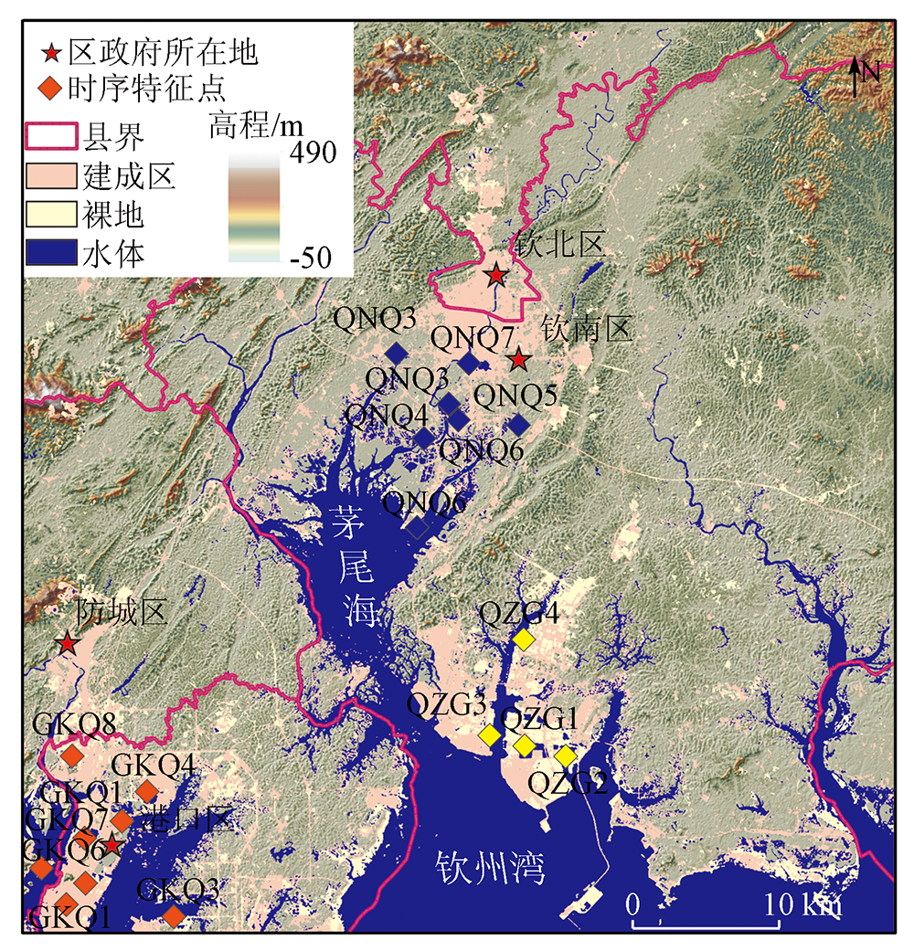
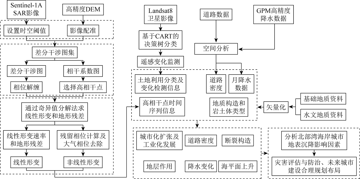
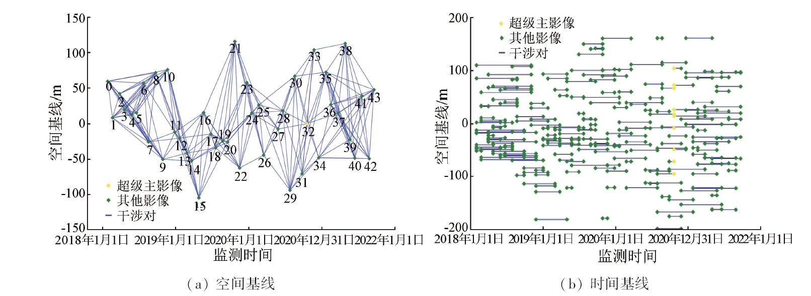
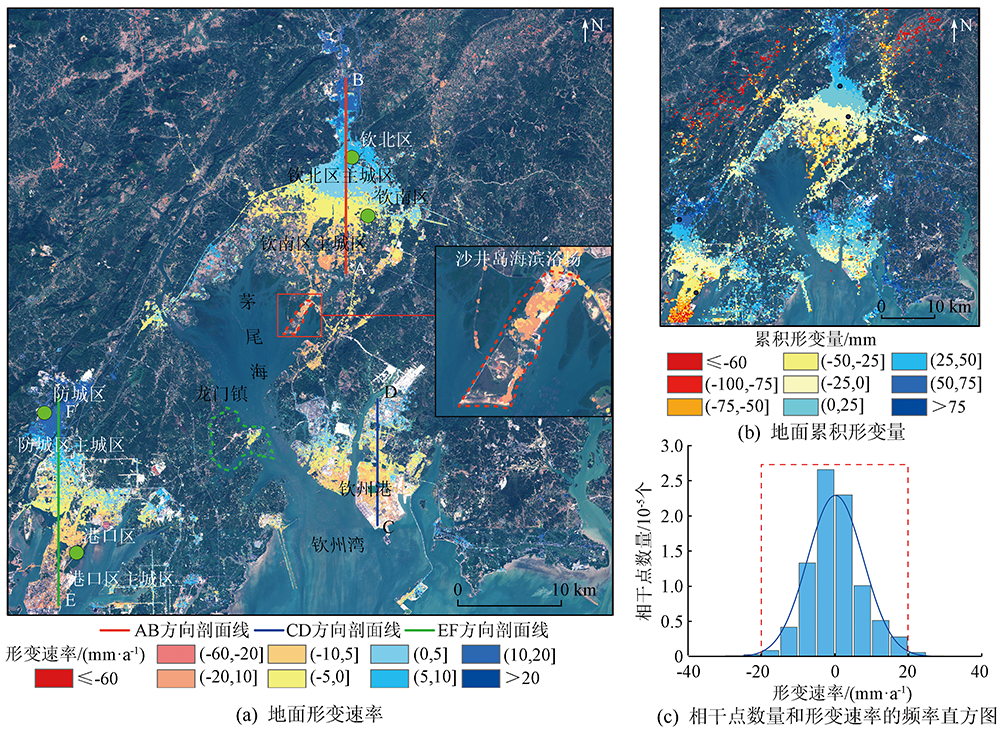
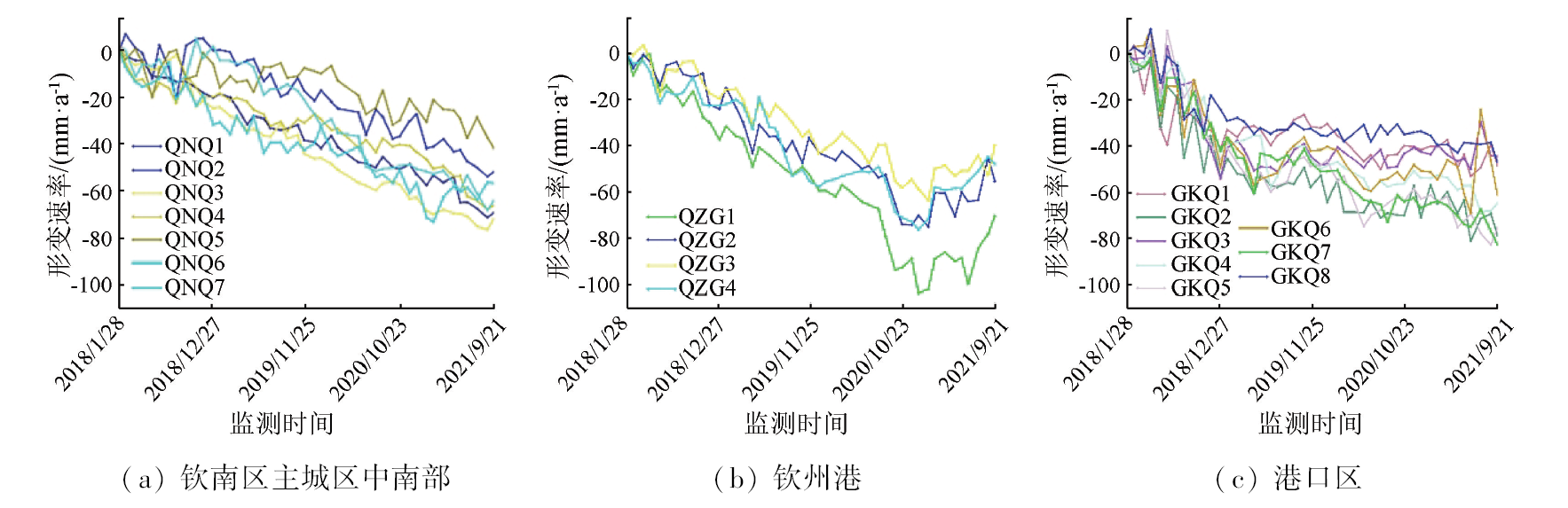
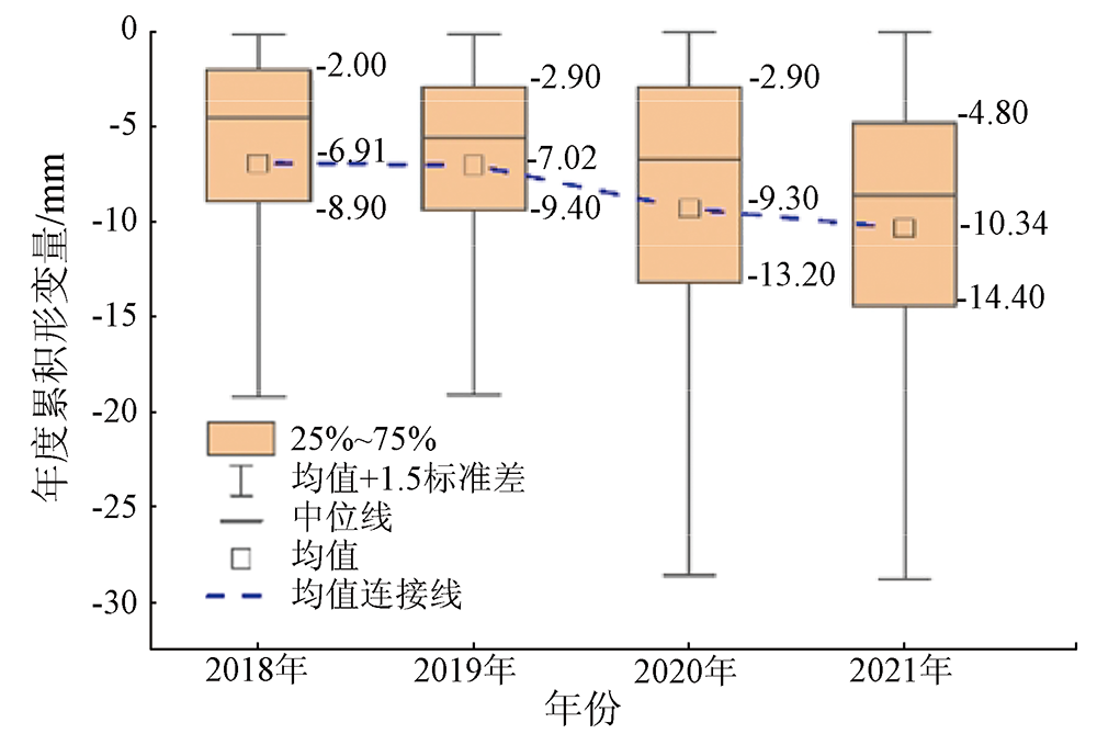
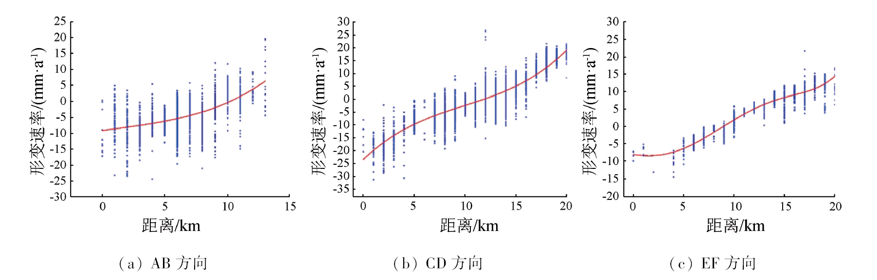
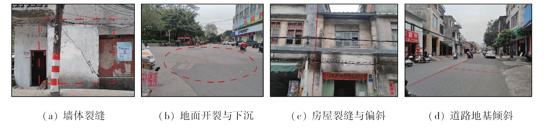
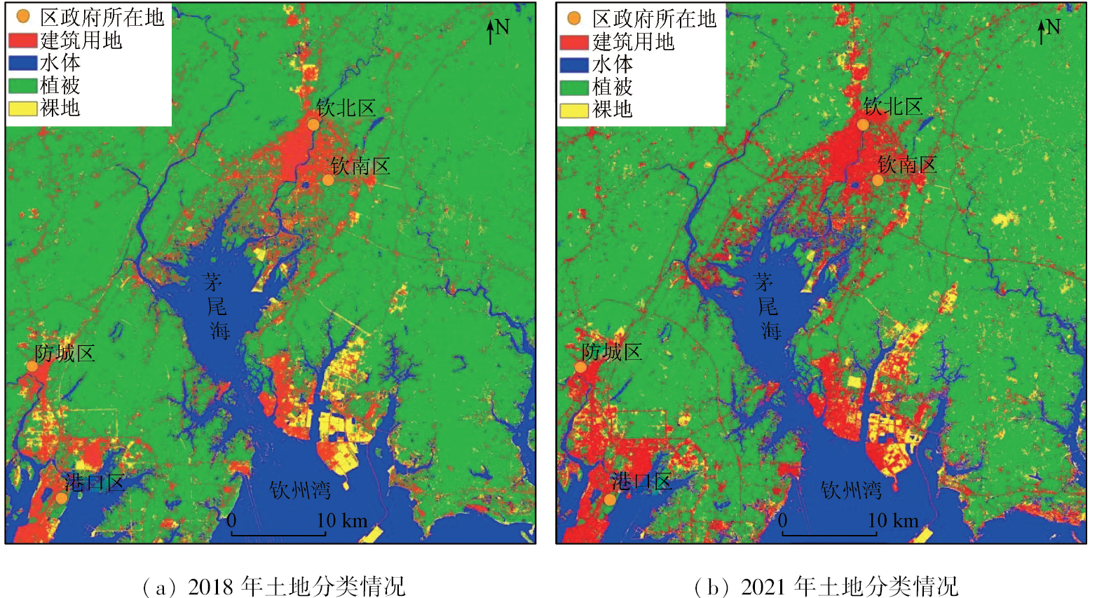
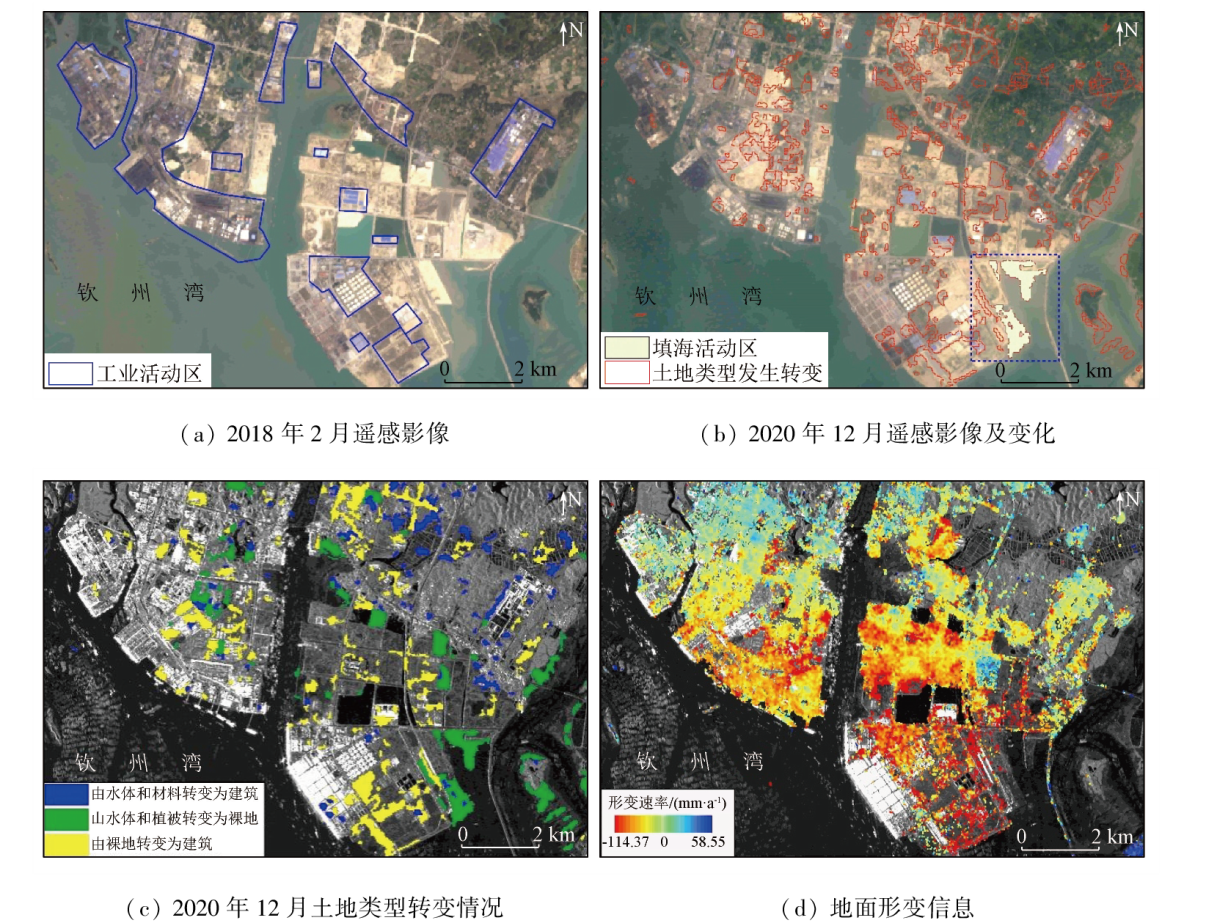
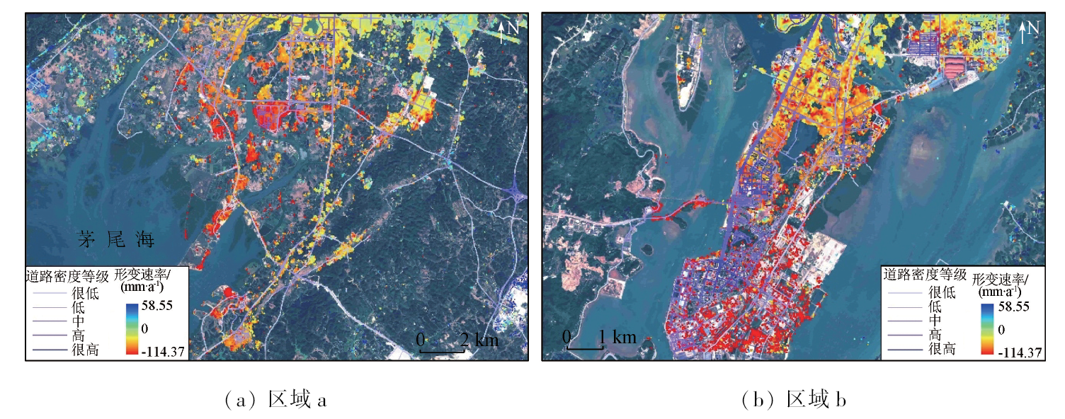
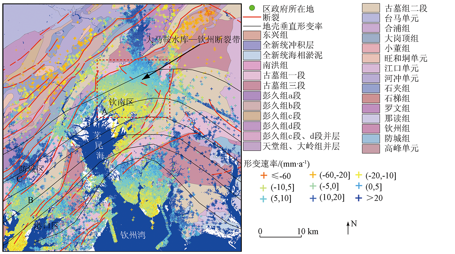
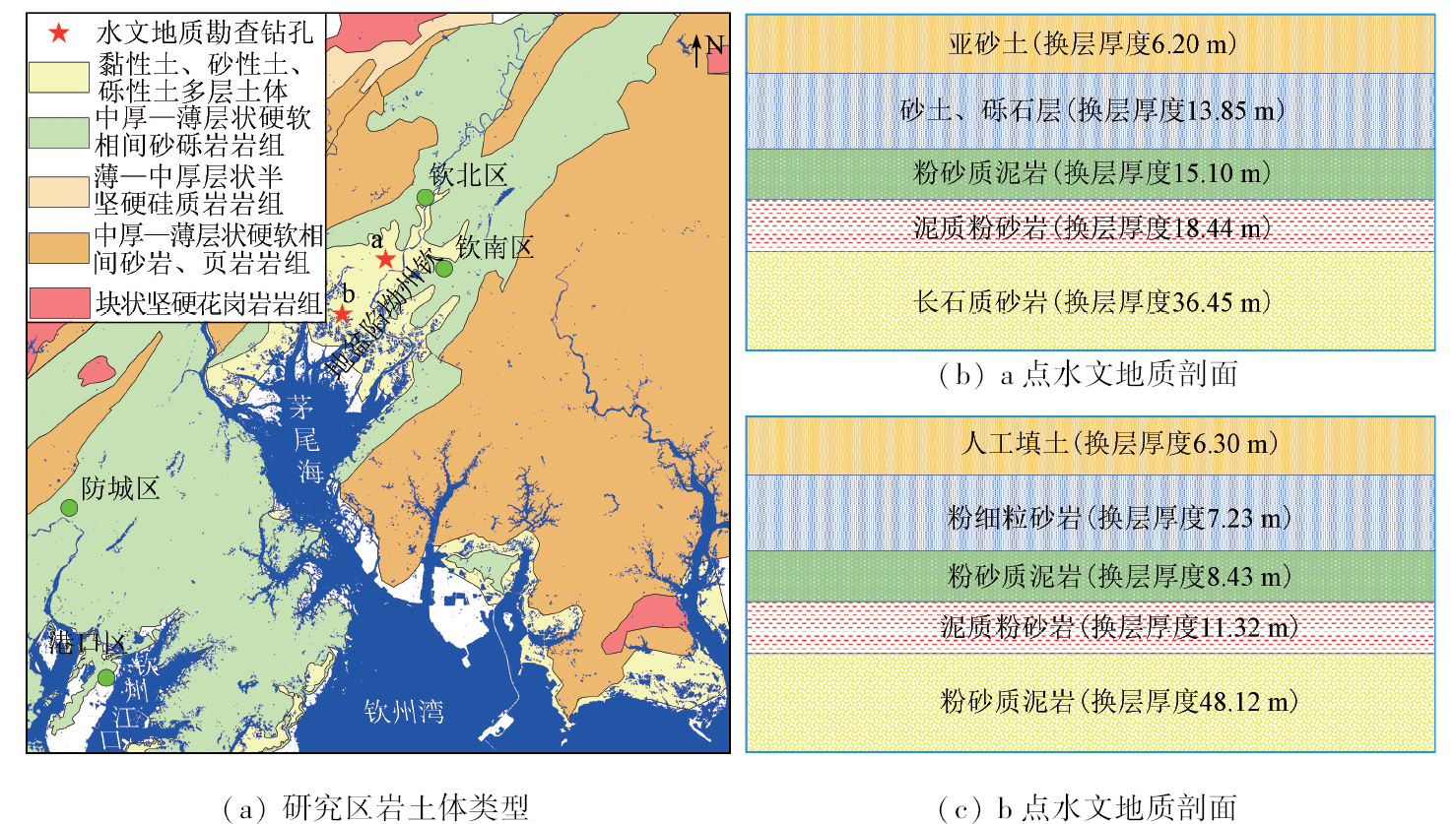
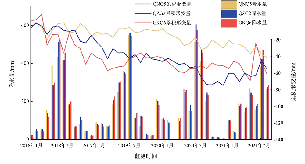
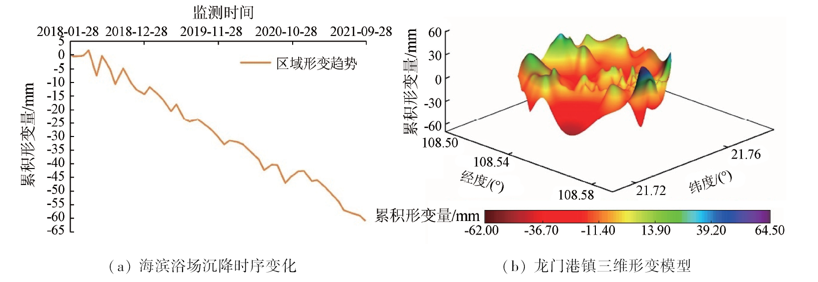
Abstract This study aims to lay the scientific foundation for regional disaster prediction, prevention, and control, as well as urban planning, by analyzing the spatio-temporal distribution, evolutionary patterns, and driving factors of land subsidence in the Qinfang area, Guangxi Province, China. Using the small baseline subset interferometric synthetic aperture radar (SBAS-InSAR) technique, this study extracted information on land subsidence in the study area during 2018—2021 from 45 scenes of Sentinel-1A SAR images. By combining the geological setting, precipitation, land use, and road data and using methods such as GIS spatial analysis, mathematical statistics, remote sensing image classification, and change detection, this study conducted visual and quantitative analyses of the overall characteristics, spatio-temporal evolutionary trends, and influencing factors of land subsidence in the study area. The results show that: ① In the spatial dimension, the ground deformations, at rates ranging from -114.37 to 58.55 mm/a within the study area, exhibited extensive but significantly nonuniform distributions during 2018—2021. Consequently, three primary subsidence centers emerged in the central and southern urban areas of Qinnan District, Qinzhou Port, and the port area, with subsidence areas expanding southward annually; ② In the temporal dimension, the subsidence centers displayed an overall uneven subsidence trend over time. Besides, they exhibited periodic rebounds, with a maximum rebound amplitude of 18.4 mm; ③ In terms of influencing factors, primary factors causing land subsidence in the study area included urbanization, road density, tectonic movement, stratigraphy, precipitation, and sea level rise, which play a predominant role in the expansion and intensification of land subsidence.
|
| Keywords
land subsidence
InSAR
Sentinel-1A
coastal cities along the Beibu Gulf
Qinfang area
time series analysis
|
|
|
|
Issue Date: 13 March 2024
|
|
|
| [44] |
Liu G W, Huang H J, Du T Q, et al. Effective factors of land subsidence in the Yellow River Delta[J]. Marine Sciences, 2011, 35(8):43-50.
|
| [45] |
董克刚, 周俊, 于强, 等. 天津市地面沉降的特征及其危害[J]. 地质灾害与环境保护, 2007, 18(1):67-70.
|
| [45] |
Dong K G, Zhou J, Yu Q, et al. Feature of the land subsidence and its damage in Tianjin City[J]. Journal of Geological Hazards and Environment Preservation, 2007, 18(1):67-70.
|
| [1] |
中华人民共和国国土资源部. DZ/T 0283—2015地面沉降调查与监测规范[S]. 北京: 中国标准出版社, 2015.
|
| [1] |
Ministry of Land and Resources of the People’s Republic of China. DZ/T 0283—2015 Specification for survey and monitoring of land subsidence[S]. Beijing: Standards Press of China, 2015.
|
| [2] |
李广宇, 张瑞, 刘国祥, 等. Sentinel-1A TS-DInSAR京津冀地区沉降监测与分析[J]. 遥感学报, 2018, 22(4):633-646.
|
| [2] |
Li G Y, Zhang R, Liu G X, et al. Land subsidence detection and analysis over Beijing-Tianjin-Hebei area based on Sentinel-1A TS-DInSAR[J]. Journal of Remote Sensing, 2018, 22(4):633-646.
|
| [3] |
杜东, 刘宏伟, 周佳慧, 等. 北京市通州区地面沉降特征与影响因素研究[J]. 地质学报, 2022, 96(2):712-725.
|
| [3] |
Du D, Liu H W, Zhou J H, et al. Study of the characteristics and influencing factors of land subsidence in the Tongzhou district of Beijing[J]. Acta Geologica Sinica, 2022, 96(2):712-725.
|
| [4] |
周吕, 鲁金金, 文学霖, 等. 基于小基线集时序干涉雷达分析武汉中心城区地表沉降时空特征[J]. 科学技术与工程, 2021, 21(1):40-46.
|
| [4] |
Zhou L, Lu J J, Wen X L, et al. Spatial-temporal characteristics analysis of ground subsidence in central urban areas of Wuhan based on small baseline subset interferometric synthetic aperture Radar[J]. Science Technology and Engineering, 2021, 21(1): 40-46.
|
| [5] |
史珉, 宫辉力, 陈蓓蓓, 等. Sentinel-1A京津冀平原区2016—2018年地面沉降InSAR监测[J]. 自然资源遥感, 2021, 33(4):55-63.doi:10.6046/zrzyyg.2020341.
|
| [5] |
Shi M, Gong H L, Chen B B, et al. Monitoring of land subsidence in Beijing-Tianjin-Hebei plain during 2016—2018 based on InSAR and Sentinel-1A data[J]. Remote Sensing for Natural Resources, 2021, 33(4):55-63.doi:10.6046/zrzyyg.2020341.
|
| [6] |
李文鹏, 王龙凤, 郭海朋, 等. 中国地面沉降防治成效与对策建议[J]. 中国水利, 2021(7):32-35.
|
| [6] |
Li W P, Wang L F, Guo H P, et al. Effectiveness and countermeasures of land subsidence control in China[J]. China Water Resources, 2021(7):32-35.
|
| [7] |
Loesch E, Sagan V. SBAS analysis of induced ground surface deformation from wastewater injection in east central Oklahoma,USA[J]. Remote Sensing, 2018, 10(2): 283.
doi: 10.3390/rs10020283
url: https://www.mdpi.com/2072-4292/10/2/283
|
| [8] |
Doke R, Kikugawa G, Itadera K. Very local subsidence near the hot spring region in Hakone Volcano,Japan,inferred from InSAR time series analysis of ALOS/PALSAR data[J]. Remote Sensing, 2020, 12(17):2842.
doi: 10.3390/rs12172842
url: https://www.mdpi.com/2072-4292/12/17/2842
|
| [9] |
Lubitz C, Motagh M, Wetzel H U, et al. Remarkable urban uplift in Staufen im Breisgau,Germany:Observations from TerraSAR-X InSAR and leveling from 2008 to 2011[J]. Remote Sensing, 2013, 5(6):3082-3100.
doi: 10.3390/rs5063082
url: http://www.mdpi.com/2072-4292/5/6/3082
|
| [10] |
董山, 张永红, 李明巨, 等. 时序InSAR的连云港及盐城北部地表沉降研究[J]. 测绘科学, 2019, 44(3):57-62.
|
| [10] |
Dong S, Zhang Y H, Li M J, et al. Surface subsidence research of Lianyungang and northern Yancheng based on time series InSAR technology[J]. Science of Surveying and Mapping, 2019, 44(3):57-62.
|
| [11] |
李梦梦, 范雪婷, 陈超, 等. 徐州矿区2016—2018年地面沉降监测与分析[J]. 自然资源遥感, 2021, 33(4):43-54.doi:10.6046/zrzyyg.2020137.
|
| [11] |
Li M M, Fan X T, Chen C, et al. Monitoring and interpretation of land subsidence in mining areas in Xuzhou City during 2016—2018[J]. Remote Sensing for Natural Resources, 2021, 33(4):43-54.doi:10.6046/zrzyyg.2020137.
|
| [12] |
任超, 施显健, 周吕, 等. 基于哨兵-1A时间序列合成孔经雷达的地铁沿线地面沉降监测与分析[J]. 科学技术与工程, 2020, 20(2):803-808.
|
| [12] |
Ren C, Shi X J, Zhou L, et al. Land subsidence detection and analysis along subway based on Sentinel-1A time series interferometry synthetic aperture Radar[J]. Science Technology and Engineering, 2020, 20(2):803-808.
|
| [13] |
史绪国, 张路, 许强, 等. 黄土台塬滑坡变形的时序InSAR监测分析[J]. 武汉大学学报(信息科学版), 2019, 44(7):1027-1034.
|
| [13] |
Shi X G, Zhang L, Xu Q, et al. Monitoring slope displacements of loess terrace using time series InSAR analysis technique[J]. Geomatics and Information Science of Wuhan University, 2019, 44(7):1027-1034.
|
| [14] |
许强, 蒲川豪, 赵宽耀, 等. 延安新区地面沉降时空演化特征时序InSAR监测与分析[J]. 武汉大学学报(信息科学版), 2021, 46(7):957-969.
|
| [14] |
Xu Q, Pu C H, Zhao K Y, et al. Time series InSAR monitoring and analysis of spatiotemporal evolution characteristics of land subsidence in Yan’an new district[J]. Geomatics and Information Science of Wuhan University, 2021, 46(7):957-969.
|
| [15] |
Dai K R, Shi X L, Gou J S, et al. Diagnosing subsidence geohazard at Beijing Capital International Airport,from high-resolution SAR interferometry[J]. Sustainability, 2020, 12(6): 2269.
doi: 10.3390/su12062269
url: https://www.mdpi.com/2071-1050/12/6/2269
|
| [16] |
Zhang Z J, Wang C, Wang M M, et al. Surface deformation monitoring in Zhengzhou City from 2014 to 2016 using time-series InSAR[J]. Remote Sensing, 2018, 10(11): 1731.
doi: 10.3390/rs10111731
url: http://www.mdpi.com/2072-4292/10/11/1731
|
| [17] |
林珲, 马培峰, 王伟玺. 监测城市基础设施健康的星载MT-InSAR方法介绍[J]. 测绘学报, 2017, 46(10):1421-1433.
doi: 10.11947/j.AGCS.2017.20170339
|
| [17] |
Lin H, Ma P F, Wang W X. Urban infrastructure health monitoring with spaceborne multi-temporal synthetic aperture Radar interfero-metry[J]. Acta Geodaetica et Cartographica Sinica, 2017, 46(10):1421-1433.
|
| [18] |
朱建军, 李志伟, 胡俊. InSAR变形监测方法与研究进展[J]. 测绘学报, 2017, 46(10):1717-1733.
doi: 10.11947/j.AGCS.2017.20170350
|
| [18] |
Zhu J J, Li Z W, Hu J. Research progress and methods of InSAR for deformation monitoring[J]. Acta Geodaetica et Cartographica Sinica, 2017, 46(10):1717-1733.
doi: 10.11947/j.AGCS.2017.20170350
|
| [19] |
何平, 许才军, 温扬茂, 等. 时序InSAR的误差模型建立及模拟研究[J]. 武汉大学学报(信息科学版), 2016, 41(6):752-758.
|
| [19] |
He P, Xu C J, Wen Y M, et al. Analysis and simulation for time series InSAR error model[J]. Geomatics and Information Science of Wuhan University, 2016, 41(6):752-758.
|
| [20] |
潘超, 江利明, 孙奇石, 等. 基于Sentinel-1雷达影像的成都市地面沉降InSAR监测分析[J]. 大地测量与地球动力学, 2020, 40(2):198-203.
|
| [20] |
Pan C, Jiang L M, Sun Q S, et al. Monitoring and analyzing Chengdu ground subsidence based on InSAR technology by using Sentinel-1 Radar image[J]. Journal of Geodesy and Geodynamics, 2020, 40(2):198-203.
|
| [21] |
杨旺, 何毅, 张立峰, 等. 甘肃金川矿区地表三维形变InSAR监测[J]. 自然资源遥感, 2022, 34(1):177-188.doi:10.6046/zrzyyg.2021107.
|
| [21] |
Yang W, He Y, Zhang L F, et al. InSAR monitoring of 3D surface deformation in Jinchuan mining area,Gansu Province[J]. Remote Sensing for Natural Resources, 2022, 34(1):177-188.doi:10.6046/zrzyyg.2021107.
|
| [22] |
Lanari R, Mora O, Manunta M, et al. A small-baseline approach for investigating deformations on full-resolution differential SAR interferograms[J]. IEEE Transactions on Geoscience and Remote Sensing, 2004, 42(7):1377-1386.
doi: 10.1109/TGRS.2004.828196
url: http://ieeexplore.ieee.org/document/1315820/
|
| [23] |
Ferretti A, Prati C, Rocca F. Permanent scatterers in SAR interferometry[C]// IEEE International Geoscience and Remote Sensing Symposium.IEEE, 1999:1528-1530.
|
| [24] |
Berardino P, Fornaro G, Lanari R, et al. A new algorithm for surface deformation monitoring based on small baseline differential SAR interferograms[J]. IEEE Transactions on Geoscience and Remote Sensing, 2002, 40(11): 2375-2383.
doi: 10.1109/TGRS.2002.803792
url: http://ieeexplore.ieee.org/document/1166596/
|
| [25] |
刘琦, 岳国森, 丁孝兵, 等. 佛山地铁沿线时序InSAR形变时空特征分析[J]. 武汉大学学报(信息科学版), 2019, 44(7):1099-1106.
|
| [25] |
Liu Q, Yue G S, Ding X B, et al. Temporal and spatial characteristics analysis of deformation along Foshan subway using time series InSAR[J]. Geomatics and Information Science of Wuhan University, 2019, 44(7):1099-1106.
|
| [26] |
周吕, 郭际明, 李昕, 等. 基于SBAS-InSAR的北京地区地表沉降监测与分析[J]. 大地测量与地球动力学, 2016, 36(9):793-797.
|
| [26] |
Zhou L, Guo J M, Li X, et al. Monitoring and analyzing on ground settlement in Beijing area based on SBAS-InSAR[J]. Journal of Geodesy and Geodynamics, 2016, 36(9):793-797.
|
| [27] |
张子文, 杨帆, 吴文豪, 等. 地下水开采与地面沉降关系的短基线集分析[J]. 测绘科学, 2016, 41(6):64-69,134.
|
| [27] |
Zhang Z W, Yang F, Wu W H, et al. Study of land subsidence and groundwater based on SBAS time-series analysis[J]. Science of Surveying and Mapping, 2016, 41(6):64-69,134.
|
| [28] |
曹群, 陈蓓蓓, 宫辉力, 等. 基于SBAS和IPTA技术的京津冀地区地面沉降监测[J]. 南京大学学报(自然科学版), 2019, 55(3):381-391.
|
| [28] |
Cao Q, Chen B B, Gong H L, et al. Monitoring of land subsidence in Beijing-Tianjin-Hebei urban by combination of SBAS and IPTA[J]. Journal of Nanjing University(Natural Science), 2019, 55(3):381-391.
|
| [29] |
莫莹, 江利明, 孙奇石, 等. 杭州湾上虞地区SBAS-InSAR地面沉降监测分析[J]. 测绘科学, 2020, 45(10):77-84.
|
| [29] |
Mo Y, Jiang L M, Sun Q S, et al. Monitoring and analysis of land subsidence in Shangyu area of Hangzhou Bay by SBAS-InSAR[J]. Science of Surveying and Mapping, 2020, 45(10):77-84.
|
| [30] |
郭乐萍, 岳建平, 岳顺. SBAS技术在南京河西地表沉降监测中的应用[J]. 测绘通报, 2017(3):26-28,41.
doi: 10.13474/j.cnki.11-2246.2017.0077
|
| [30] |
Guo L P, Yue J P, Yue S. Application of SBAS technique in surface subsidence monitoring of Nanjing Hexi area[J]. Bulletin of Surveying and Mapping, 2017(3):26-28,41.
doi: 10.13474/j.cnki.11-2246.2017.0077
|
| [31] |
熊佳诚, 聂运菊, 罗跃, 等. 利用双极化Sentinel-1数据监测城市地面沉降——以上海市为例[J]. 测绘通报, 2019(11):98-102,129.
doi: 10.13474/j.cnki.11-2246.2019.0360
|
| [31] |
Xiong J C, Nie Y J, Luo Y, et al. Monitoring urban land subsidence by dual-polarization Sentinel-1 data:A case study of Shanghai[J]. Bulletin of Surveying and Mapping, 2019(11):98-102,129.
|
| [32] |
董少春, 种亚辉, 胡欢, 等. 基于时序InSAR的常州市2015—2018年地面沉降监测[J]. 南京大学学报(自然科学版), 2019, 55(3):370-380.
|
| [32] |
Dong S C, Chong Y H, Hu H, et al. Ground subsidence monitoring during 2015—2018 in Changzhou based on time series InSAR method[J]. Journal of Nanjing University(Natural Science), 2019, 55(3):370-380.
|
| [33] |
赵超英, 张勤, 朱武. 采用TerraSAR-X数据监测西安地裂缝形变[J]. 武汉大学学报(信息科学版), 2012, 37(1):81-85.
|
| [33] |
Zhao C Y, Zhang Q, Zhu W. Monitoring on Xi’an ground fissures deformation with TerraSAR-X data[J]. Geomatics and Information Science of Wuhan University, 2012, 37(1):81-85.
|
| [34] |
张艳梅, 王萍, 罗想, 等. 利用Sentinel-1数据和SBAS-InSAR技术监测西安地表沉降[J]. 测绘通报, 2017(4):93-97.
doi: 10.13474/j.cnki.11-2246.2017.0128
|
| [34] |
Zhang Y M, Wang P, Luo X, et al. Monitoring Xi’an land subsidence using Sentinel-1 images and SBAS-InSAR technology[J]. Bulletin of Surveying and Mapping, 2017(4):93-97.
|
| [35] |
李达, 邓喀中, 高晓雄, 等. 基于SBAS-InSAR的矿区地表沉降监测与分析[J]. 武汉大学学报(信息科学版), 2018, 43(10):1531-1537.
|
| [35] |
Li D, Deng K Z, Gao X X, et al. Monitoring and analysis of surface subsidence in mining area based on SBAS-InSAR[J]. Geomatics and Information Science of Wuhan University, 2018, 43(10):1531-1537.
|
| [36] |
姜德才, 张继贤, 张永红, 等. 百年煤城地表沉降融合PS/SBAS InSAR监测——以徐州市为例[J]. 测绘通报, 2017(1):58-64.
doi: 10.13474/j.cnki.11-2246.2017.0013
|
| [36] |
Jiang D C, Zhang J X, Zhang Y H, et al. Ground deformation over century-long coal mining city monitored through incorporating both PS and SBAS InSAR:A case study of Xuzhou[J]. Bulletin of Surveying and Mapping, 2017(1):58-64.
|
| [37] |
Henry E R, Hofrichter J. Singular value decomposition:Application to analysis of experimental data[J]. Methods in Enzymology, 1992, 210: 129-192.
|
| [38] |
覃纹, 黄秋燕, 庾露, 等. 南宁在建地铁沿线地表沉降监测[J]. 地球信息科学学报, 2019, 21(9):1467-1478.
doi: 10.12082/dqxxkx.2019.190151
|
| [38] |
Qin W, Huang Q Y, Yu L, et al. Surface subsidence monitoring during the construction of Nanning subways[J]. Journal of Geo-Information Science, 2019, 21(9):1467-1478.
|
| [39] |
莫永杰, 李平日, 方国祥, 等. 海平面上升对广西沿海的影响与对策[M]. 北京: 科学出版社, 1996:70-72.
|
| [39] |
Mo Y J, Li P R, Fang G X, et al. Influence of sea level rise on Guangxi coastal areas and its countermeasures[M]. Beijing: Science Press, 1996:70-72.
|
| [40] |
张继淹. 广西地质构造稳定性分析与评价[J]. 广西地质, 2002(3):1-7.
|
| [40] |
Zhang J Y. Analysis and appraise of geology structure stabilization of Guangxi[J]. Guangxi Geology, 2002(3):1-7.
|
| [41] |
陈宏明, 吴祥和, 张英, 等. 中国南方石炭纪岩相古地理与成矿作用[M]: 地质出版社, 1994:34-35.
|
| [41] |
Chen H M, Wu X H, Zhang Y, et al. Carboniferous lithofacies paleogeography and mineralization in south China[M]: Geological Publishing House, 1994:34-35.
|
| [42] |
何军, 黎清华, 刘怀庆, 等. 北部湾经济区主要环境地质问题探讨[J]. 华南地质与矿产, 2015, 31(1):96-103.
|
| [42] |
He J, Li Q H, Liu H Q, et al. Review on the main geological environmental problems in Beibu Gulf Economic Zone[J]. Geology and Mineral Resources of South China, 2015, 31(1):96-103.
|
| [43] |
韦友道. 浅谈广西沿海地区海堤工程主要工程地质问题[J]. 广西水利水电, 1999(3):30-34.
|
| [43] |
Wei Y D. Elementary discussion on the main engineering geologic problems of Guangxi coastal region sea embankment project[J]. Guangxi Water Resources and Hydropower Engineering, 1999(3):30-34.
|
| [44] |
刘桂卫, 黄海军, 杜廷芹, 等. 黄河三角洲地区地面沉降驱动因素研究[J]. 海洋科学, 2011, 35(8):43-50.
|
|
Viewed |
|
|
|
Full text
|
|
|
|
|
Abstract
|
|
|
|
|
Cited |
|
|
|
|
| |
Shared |
|
|
|
|
| |
Discussed |
|
|
|
|
 2024,
Vol. 36
2024,
Vol. 36