|
|
 |
|

|
|
|
Research on automatic extraction method for coastal aquaculture area using Landsat8 data |
Yitian WU1,2, Fu CHEN1( ), Yong MA1, Jianbo LIU1, Xinpeng LI1 ), Yong MA1, Jianbo LIU1, Xinpeng LI1 |
1. Institute of Remote Sensing and Digital Earth, CAS, Beijing 100101, China
2. University of Chinese Academy of Science, Beijing 100049, China |
|
|
|
|
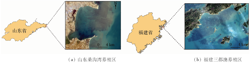
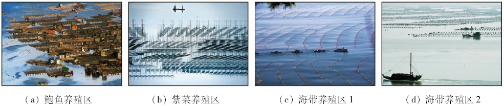
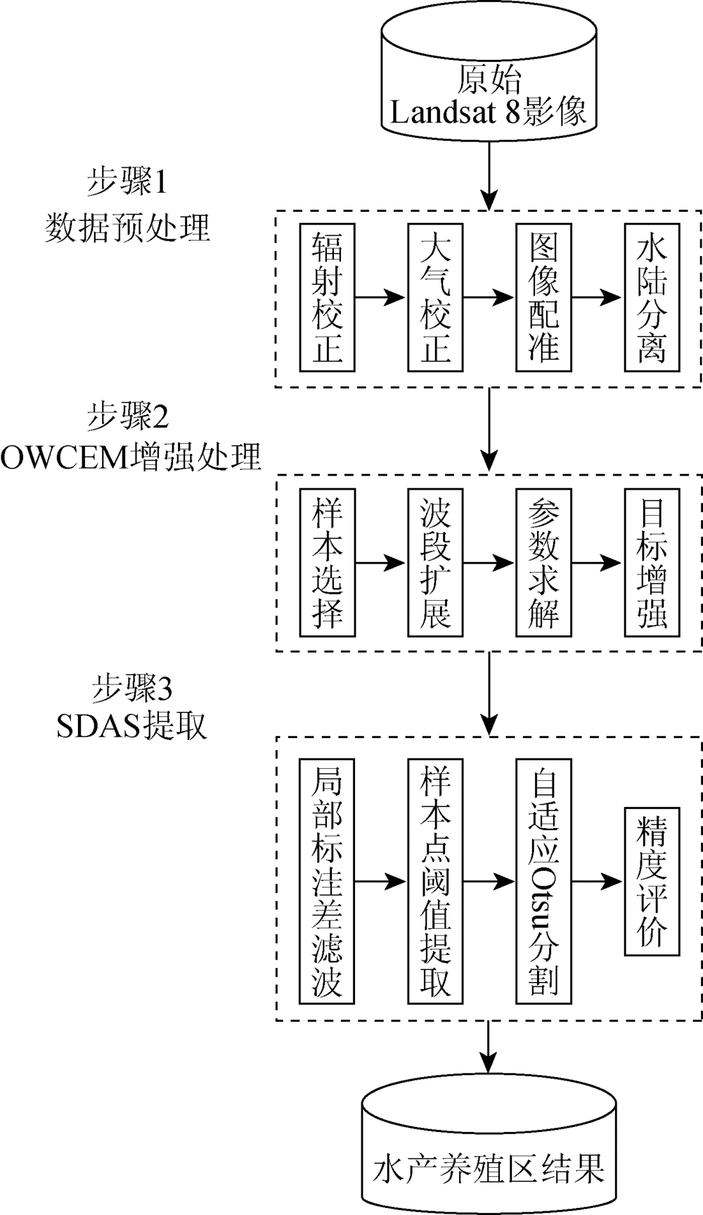
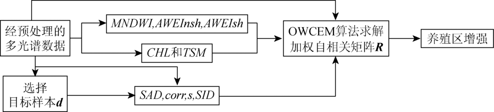
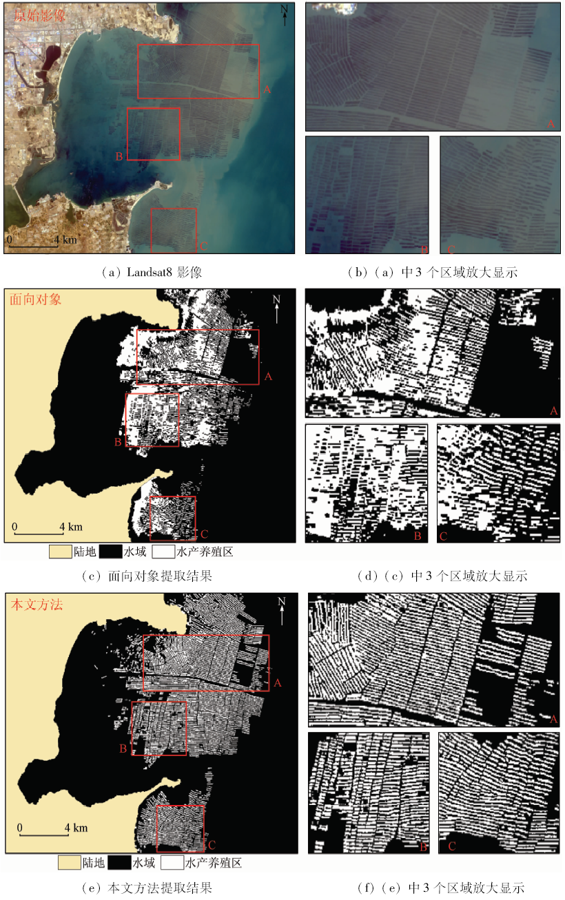
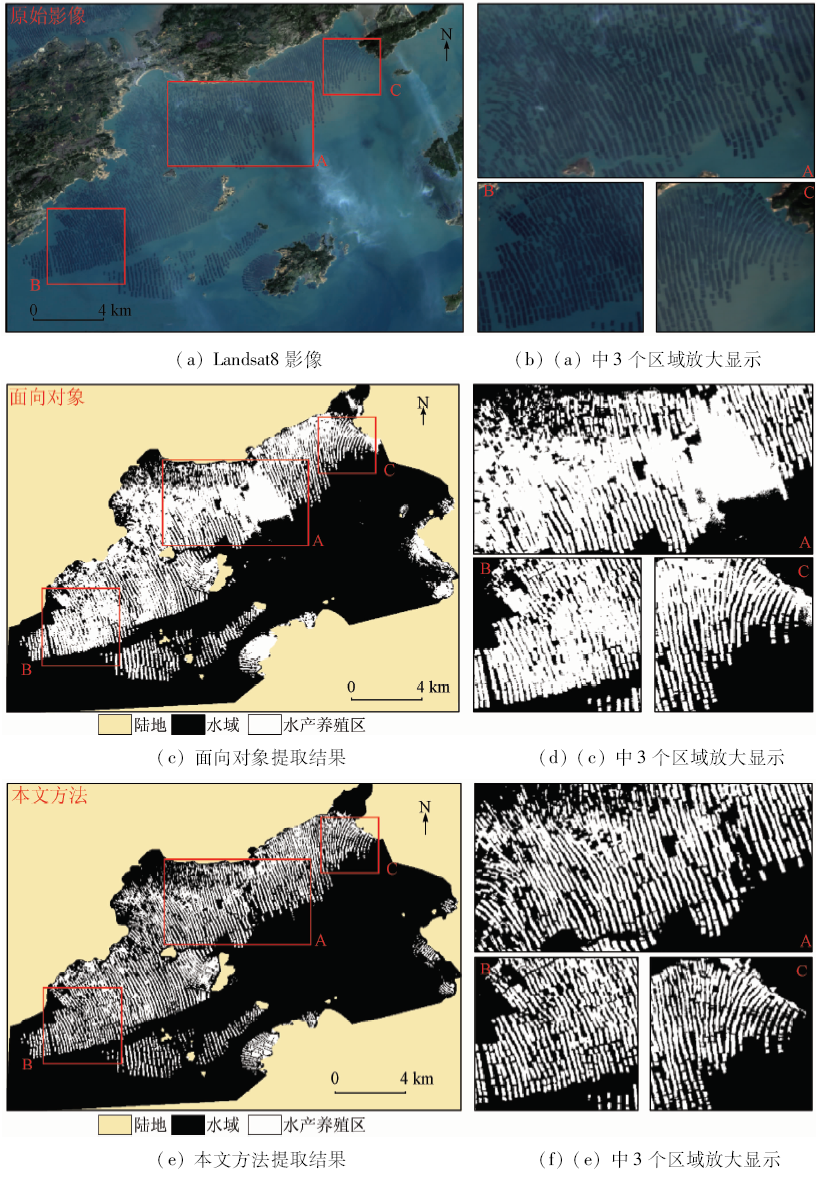
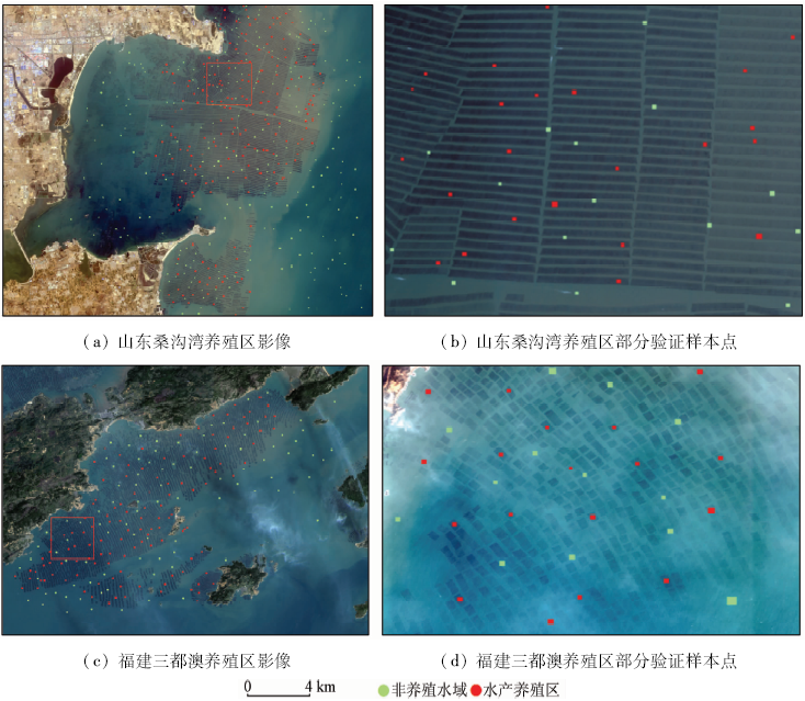
Abstract During coastal resource monitoring, it is an effective way to extract aquaculture region using remote sensing data, whereas the water color in coastal region is complexly influenced by the distribution difference of chlorophyll-a and total suspended sediment concentration. And it would be difficult to accurately extract the aquaculture region with complex background using traditional methods. In view of the above problem, the authors proposed an algorithm for automatic coastal aquaculture area extraction combined with spectral and spatial information of aquaculture. Firstly, orthogonal subspace projection-weighted constrained energy minization method (OWCEM) was used to enhance the information of coastal aquaculture area. Secondly, by using the spatial texture information of the coastal aquaculture area, standard deviation adaptive segmentation (SDAS) method was used to automatically extract the cultivation area. In order to verify the accuracy of the proposed algorithm, the authors selected Sanggou Bay in Shandong and Sanduao Bay in Fujian as test regions and conducted the area extraction using Landsat8 data. The experimental results show that the proposed method can rapidly and accurately identify the distribution of coastal aquaculture area in complex background color and can reach about 93% accuracy rate with a low missing rate. The method could provide a new and effective means for automatic extraction of offshore aquaculture area.
|
| Keywords
coastal aquaculture region extraction
standard deviation adaptive segmentation(SDAS)
complex background
orthogonal subspace projection-weighted constrained energy minization(OWCEM)
|
|
|
|
Corresponding Authors:
Fu CHEN
E-mail: chenfu@radi.ac.cn
|
|
Issue Date: 10 September 2018
|
|
|
| [1] |
FAO. The State of World Fisheries and Aquaculture 2014[R]. Rome:FAO, 2014: 40-41.
|
| [2] |
程田飞, 周为峰, 樊伟 . 水产养殖区域的遥感识别方法进展[J]. 国土资源遥感, 2012,24(3):1-5.doi: 10.6046/gtzyyg.2012.03.01.
doi: 10.6046/gtzyyg.2012.03.01
|
| [2] |
Cheng T F, Zhou W F, Fan W . Progress in the methods for extracting aquaculture areas from remote sensing data[J]. Remote Sensing for Land and Resources, 2012,24(3):1-5.doi: 10.6046/gtzyyg.2012.03.01.
|
| [3] |
马艳娟, 赵冬玲, 王瑞梅 , 等. 基于ASTER数据的近海水产养殖区提取方法[J]. 农业工程学报, 2010,26(14):120-124.
|
| [3] |
Ma Y J, Zhao D L, Wang R M , et al. Offshore aquatic farming areas extraction method based on ASTER data[J]. Transactions of the CSAE, 2010,26(14):120-124.
|
| [4] |
周小成, 汪小钦, 向天梁 , 等. 基于ASTER影像的近海水产养殖信息自动提取方法[J]. 湿地科学, 2006,4(1):64-68.
doi: 10.3969/j.issn.1672-5948.2006.01.010
url: http://d.wanfangdata.com.cn/Periodical/shidkx200601010
|
| [4] |
Zhou X C, Wang X Q, Xiang T L , et al. Method of automatic extracting seaside aquaculture land based on ASTER remote sensing image[J]. Wetland Science, 2006,4(1):64-68.
|
| [5] |
林桂兰, 孙飒梅, 曾良杰 , 等. 高分辨率遥感技术在厦门海湾生态环境调查中的应用[J]. 台湾海峡, 2003,22(2):242-247.
doi: 10.3969/j.issn.1000-8160.2003.02.018
url: http://d.wanfangdata.com.cn/Periodical_twhx200302018.aspx
|
| [5] |
Lin G L, Sun S M, Zeng L J , et al. Application of high resolution satellite remote sensing in survey of ecological environment at Xiamen Bay[J]. Journal of Oceanography in Taiwan Strait, 2003,22(2):242-247.
|
| [6] |
孙晓宇, 苏奋振, 周成虎 , 等. 基于RS与GIS的珠江口养殖用地时空变化分析[J]. 资源科学, 2010,32(1):71-77.
url: http://d.wanfangdata.com.cn/Periodical/zykx201001010
|
| [6] |
Sun X Y, Su F Z, Zhou C H , et al. Analyses on spatial-temporal changes in aquaculture land in coastal areas of the Pearl River Estuarine[J]. Resources Science, 2010,32(1):71-77.
|
| [7] |
卢业伟, 李强子, 杜鑫 , 等. 基于高分辨率影像的近海养殖区的一种自动提取方法[J]. 遥感技术与应用, 2015,30(3):486-494.
doi: 10.11873/j.issn.1004-0323.2015.3.0486
|
| [7] |
Lu Y W, Li Q Z, Du X , et al. A method of coastal aquaculture area automatic extraction with high spatial resolution images[J]. Remote Sensing Technology and Application, 2015,30(3):486-494.
|
| [8] |
Ji L Y, Geng X R, Sun K , et al. Target detection method for water mapping using Landsat 8 OLI/TIRS imagery[J]. Water, 2015,7(2):794-817.
doi: 10.3390/w7020794
url: http://www.mdpi.com/2073-4441/7/2/794
|
| [9] |
Chen J, Chen J, Liao A P , et al. Global land cover mapping at 30 m resolution:A POK-based operational approach[J]. ISPRS Journal of Photogrammetry and Remote Sensing, 2015,103:7-27.
doi: 10.1016/j.isprsjprs.2014.09.002
url: http://linkinghub.elsevier.com/retrieve/pii/S0924271614002275
|
| [10] |
Farrand W H, Harsanyi J C . Mapping the distribution of mine tailings in the Coeur d’Alene River Valley,Idaho,through the use of a constrained energy minimization technique[J]. Remote Sensing of Environment, 1997,59(1):64-76.
doi: 10.1016/S0034-4257(96)00080-6
url: http://linkinghub.elsevier.com/retrieve/pii/S0034425796000806
|
| [11] |
Geng X R, Ji L Y, Sun K , et al. CEM:More bands,better performance[J]. IEEE Geoscience and Remote Sensing Letters, 2014,11(11):1876-1880.
doi: 10.1109/LGRS.2014.2312319
url: http://ieeexplore.ieee.org/document/6786322/
|
| [12] |
Xu H Q . Modification of normalised difference water index (NDWI) to enhance open water features in remotely sensed imagery[J]. International Journal of Remote Sensing, 2006,27(14):3025-3033.
doi: 10.1080/01431160600589179
url: http://www.tandfonline.com/doi/abs/10.1080/01431160600589179
|
| [13] |
Feyisa G L, Meilby H, Fensholt R , et al. Automated water extraction index:A new technique for surface water mapping using Landsat imagery[J]. Remote Sensing of Environment, 2014,140:23-35.
doi: 10.1016/j.rse.2013.08.029
url: http://linkinghub.elsevier.com/retrieve/pii/S0034425713002873
|
| [14] |
邬明权, 韩松, 赵永清 , 等. 应用Landsat TM影像估算渤海叶绿素a和总悬浮物浓度[J]. 遥感信息, 2012,27(4):91-95.
doi: 10.3969/j.issn.1000-3177.2012.04.016
url: http://d.wanfangdata.com.cn/Periodical/ygxx201204016
|
| [14] |
Wu M Q, Han S, Zhao Y Q , et al. Quantitative estimation of chlorophyll-a and total suspended matter concentration with Landsat TM[J]. Remote Sensing Information, 2012,27(4):91-95.
|
| [15] |
Chang C I . An information-theoretic approach to spectral variability,similarity,and discrimination for hyperspectral image analysis[J]. IEEE Transactions on Information Theory, 2000,46(5):1927-1932.
doi: 10.1109/18.857802
url: http://ieeexplore.ieee.org/document/857802/
|
| [16] |
Otsu N . A threshold selection method from gray-level histograms[J]. IEEE Transactions on Systems,Man,and Cybernetics, 1979,9(1):62-66.
doi: 10.1109/TSMC.1979.4310076
url: http://ieeexplore.ieee.org/document/4310076/
|
|
Viewed |
|
|
|
Full text
|
|
|
|
|
Abstract
|
|
|
|
|
Cited |
|
|
|
|
| |
Shared |
|
|
|
|
| |
Discussed |
|
|
|
|
 2018,
Vol. 30
2018,
Vol. 30