|
|
|
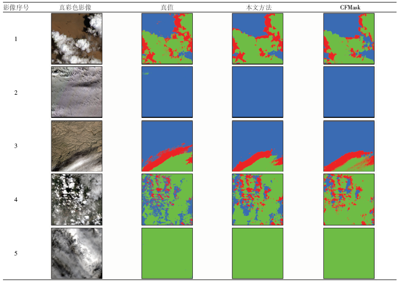
Abstract Cloud and cloud shadow detection is an important part in the production of Landsat images. In recent years, deep learning has greatly improved the accuracy of cloud detection in Landsat images. However, deep convolutional neural network model training relies on a large scale of labeled images, and it is necessary to manually label each pixel as clearness, cloud or cloud shadow. Manually labeling is rather costly and time-consuming, which is not conducive to train practical models. Inspired by weakly supervised learning, this paper proposes a new deep learning method for cloud and cloud shadow detection. Firstly, conventional cloud detection algorithm CFMask is used to detect cloud and cloud shadow in Landsat images. Then, the results are used to replace the manually labeled images to train the deep convolutional neural network model for cloud detection. Finally, the model is used to detect the cloud and its shadow in new images. Experimental results show that the overall accuracy of the proposed method is 85.55%, which is better than that of CFMask and indicates that it is feasible to train the deep network model to detect cloud and cloud shadow without manually labeled data.
|
| Keywords
cloud and cloud shadow detection
Landsat8 image
convolutional neural network
semantic segmentation
|
|
|
|
Corresponding Authors:
CHAI Dengfeng
E-mail: rs_qyf@zju.edu.cn;chaidf@zju.edu.cn
|
|
Issue Date: 18 March 2021
|
|
|
| [1] |
Foga S, Scaramuzza P L, Guo S, et al. Cloud detection algorithm comparison and validation for operational Landsat data products[J]. Remote Sensing of Environment, 2017,194:379-390.
doi: 10.1016/j.rse.2017.03.026
url: https://linkinghub.elsevier.com/retrieve/pii/S0034425717301293
|
| [2] |
Ju J, Roy D P. The availability of cloud-free Landsat ETM+ data over the conterminous United States and globally[J]. Remote Sensing of Environment. 2008,112(3):1196-1211.
doi: 10.1016/j.rse.2007.08.011
url: https://linkinghub.elsevier.com/retrieve/pii/S0034425707004002
|
| [3] |
Rossow W B, Schiffer R A. Advances in understanding clouds from ISCCP[J]. Bulletin of the American Meteorological Society, 1999,80(11):2261-2287.
doi: 10.1175/1520-0477(1999)080<2261:AIUCFI>2.0.CO;2
url: http://journals.ametsoc.org/doi/10.1175/1520-0477(1999)080<2261:AIUCFI>2.0.CO;2
|
| [4] |
Fisher A. Cloud and cloud-shadow detection in SPOT5 HRG imagery with automated morphological feature extraction[J]. Remote Sensing, 2014,6(1):776-800.
doi: 10.3390/rs6010776
url: http://www.mdpi.com/2072-4292/6/1/776
|
| [5] |
Zhu Z, Woodcock C E. Automated cloud,cloud shadow,and snow detection in multitemporal Landsat data:An algorithm designed specifically for monitoring land cover change[J]. Remote Sensing of Environment, 2014,152:217-234.
doi: 10.1016/j.rse.2014.06.012
url: http://dx.doi.org/10.1016/j.rse.2014.06.012
|
| [6] |
Zhu Z, Woodcock C E. Object-based cloud and cloud shadow detection in Landsat imagery[J]. Remote Sensing of Environment, 2012,118:83-94.
doi: 10.1016/j.rse.2011.10.028
url: http://dx.doi.org/10.1016/j.rse.2011.10.028
|
| [7] |
Zhu Z, Wang S, Woodcock C E. Improvement and expansion of the Fmask algorithm:Cloud,cloud shadow,and snow detection for Landsats 4,7,8,and Sentinel 2 images[J]. Remote Sensing of Environment, 2015,159:269-277.
doi: 10.1016/j.rse.2014.12.014
url: https://linkinghub.elsevier.com/retrieve/pii/S0034425714005069
|
| [8] |
Irish R R, Barker J L, Goward S N, et al. Characterization of the Landsat-7 ETM+ automated cloud-cover assessment (ACCA) algorithm[J]. Photogrammetric Engineering and Remote Sensing, 2006,72(10):1179-1188.
doi: 10.14358/PERS.72.10.1179
url: http://openurl.ingenta.com/content/xref?genre=article&issn=0099-1112&volume=72&issue=10&spage=1179
|
| [9] |
Hagolle O, Huc M, Pascual D V, et al. A multi-temporal method for cloud detection, applied to FORMOSAT-2,VENμS,Landsat and Sentinel-2 images[J]. Remote Sensing of Environment, 2010,114(8):1747-1755.
doi: 10.1016/j.rse.2010.03.002
url: https://linkinghub.elsevier.com/retrieve/pii/S0034425710000908
|
| [10] |
Molnar G, Coakley J A. Retrieval of cloud covee fromsatelltte imagery data-a statistical approach[J]. Journal of Geophysical Research-Atomspheres, 1985,90(D7):2960-2970.
|
| [11] |
Ricciardelli E, Romano F, Cuomo V. Physical and statistical approaches for cloud identification using meteosat second generation-spinning enhanced visible and infrared imager data[J]. Remote Sensing of Environment, 2008,112(6):2741-2760.
|
| [12] |
Amato U, Antoniadis A, Cuomo V, et al. Statistical cloud detection from SEVIRI multispectral images[J]. Remote Sensing of Environment, 2008,112(3):750-766.
|
| [13] |
Zi Y, Xie F, Jiang Z. A cloud detection method for Landsat8 images based on PCANet[J]. Remote Sensing, 2018,10(6):877.
|
| [14] |
Xie F, Shi M, Shi Z, et al. Multilevel cloud detection in remote sensing images based on deep learning[J]. IEEE Journal of Selected Topics in Applied Earth Observations and Remote Sensing, 2017,10(8):3631-3640.
|
| [15] |
Chai D, Newsam S, Zhang H K, et al. Cloud and cloud shadow detection in Landsat imagery based on deep convolutional neural networks[J]. Remote Sensing of Environment, 2019,225:307-316.
|
| [16] |
Zhou Z. A brief introduction to weakly supervised learning[J]. National Science Review, 2018,5(1):44-53.
|
| [17] |
Deselaers T, Alexe B, Ferrari V. Weakly supervised localization and learning with generic knowledge[J]. International Journal of Computer Vision, 2012,100(3):275-293.
|
| [18] |
U.S.Geological Survey. L8 biome cloud validation masks[DB/OL].[2020-04-01]. http://dx.doi.org/10.5066/F79Z930Q.
url: http://dx.doi.org/10.5066/F79Z930Q
|
| [19] |
U.S.Geological Survey. Landsat collection 1 level-1 quality assessment band[EB/OL].[2020-04-01].https://www.usgs.gov/land-resources/nli/landsat/landsat-collection-1-level-1-quality-assessment-band.
url: https://www.usgs.gov/land-resources/nli/landsat/landsat-collection-1-level-1-quality-assessment-band
|
| [20] |
Badrinarayanan V, Kendall A, Cipolla R. SegNet:A deep convolutional encoder-decoder architecture for image segmentation[J]. IEEE Transactions on Pattern Analysis and Machine Intelligence, 2017,39(12):2481-2495.
pmid: 28060704
url: https://www.ncbi.nlm.nih.gov/pubmed/28060704
|
| [21] |
Ruder S.An overview of gradient descent optimization algorithms[EB/OL]. (2017-06-15)[2020-04-01] https://arxiv.org/abs/1609.04747.
url: https://arxiv.org/abs/1609.04747
|
| [22] |
Kingma D P, Ba J. Adam:A method for stochastic optimization[EB/OL]. (2017-01-30)[2020-04-01] https://arxiv.org/abs/1412.6980.
url: https://arxiv.org/abs/1412.6980
|
|
Viewed |
|
|
|
Full text
|
|
|
|
|
Abstract
|
|
|
|
|
Cited |
|
|
|
|
| |
Shared |
|
|
|
|
| |
Discussed |
|
|
|
|
 2021,
Vol. 33
 Issue (1)
: 102-107
DOI: 10.6046/gtzyyg.2020090
 ), CHAI Dengfeng(
 )
)

