|
|
 |
|

|
|
|
An improved multispectral image segmentation method based on super-pixels |
| Yongmei ZHANG1, Haiyan SUN1, Yulong XU2 |
1.Computer College, North China University of Technology, Beijing 100144,China
2.Section Steel Mill of Tisco, Taiyuan, 030003, China |
|
|
|
|
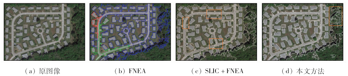
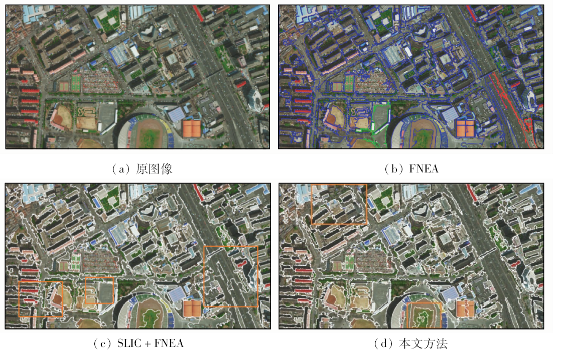
Abstract In the object-oriented multispectral image segmentation, the initial object feature may not reflect the global feature of the whole region and can lead to an incorrect merge. To solve the problem, this paper proposes a method that combines the result of the simple linear iterative clustering(SLIC) super pixel and the rough segmentation result of structure tensor. First, the SLIC process is executed to get an over-segmentation result. Then, make sure the feature of the initial object of the fractal net evolution approach can reflect the real distribution of the whole region, and do the pre-merging between the super pixels under the control of the rough segmentation result of the structure tensor in the scale space. This process can enhance the anti-noise capability of the following merging process. Finally, the final results are given; compared with the results of the traditional fractal net evolution approach(FNEA), the result shows that the method proposed in the paper has better anti-noise capability, and can get better segmentation results even in handling the complex city multispectral images.
|
| Keywords
super pixel
multispectral image
image segmentation
fractal net evolution approach
|
|
|
|
Issue Date: 15 March 2019
|
|
|
| [1] |
马燕妮, 明冬萍, 杨海平 . 面向对象影像多尺度分割最大异质性参数估计[J]. 遥感学报, 2017,21(4):566-578.
doi: 10.11834/jrs.20176374
url: http://d.wanfangdata.com.cn/Periodical/ygxb201704008
|
| [1] |
Ma Y N, Ming D P, Yang H P . Scale estimation of object-oriented image analysis based on spectral-spatial statistics[J]. Journal of Remote Sensing, 2017,21(4):566-578.
|
| [2] |
黄亮, 左小清, 冯冲 , 等. 基于Canny算法的面向对象影像分割[J]. 国土资源遥感, 2011,23(4):26-30.doi: 10.6046/gtzyyg.2011.04.05.
doi: 10.6046/gtzyyg.2011.04.05
url: http://www.cqvip.com/QK/91397X/201104/40155482.html
|
| [2] |
Huang L, Zuo X Q, Feng C , et al. Object-oriented image segmentation based on Canny algorithm[J]. Remote Sensing for Land and Resources, 2011,23(4):26-30.doi: 10.6046/gtzyyg.2011.04.05.
|
| [3] |
贾春阳, 李卫华, 李小春 . 基于自适应权值FNEA算法的高分辨率遥感图像分割[J]. 国土资源遥感, 2013,25(4):22-25.doi: 10.6046/gtzyyg.2013.04.04.
doi: 10.6046/gtzyyg.2013.04.04
url: http://www.cqvip.com/QK/91397X/201304/47907948.html
|
| [3] |
Jia C Y, Li W H, Li X C . High-resolution remote sensing image segmentation based on weight adaptive fractal net evolution approach[J]. Remote Sensing for Land and Resources, 2013,25(4):22-25.doi: 10.6046/gtzyyg.2013.04.04.
|
| [4] |
Peng P, Gao W, Liu X G, et al. An improved strategy for object-oriented multi-scale remote sensing imagesegmentation [C]//International Conference on Information Science and Engineering.IEEE, 2010: 1149-1152.
|
| [5] |
邓富亮, 范协裕, 王刚 , 等. 一种FNEA影像分割算法中初始对象的快速构建方法[J]. 中国科学院大学学报, 2014,31(4):484-491.
doi: 10.7523/j.issn.2095-6134.2014.04.007
url: http://d.wanfangdata.com.cn/Periodical/zgkxyyjsyxb201404007
|
| [5] |
Deng F L, Fan X Y, Wang G , et al. A fast method for creation of the initial objects for FNEA image segmentation[J]. Journal of University of Chinese Academy of Sciences, 2014,31(4):484-491.
|
| [6] |
张勇, 袁家政, 刘宏哲 , 等. 基于结构张量的GrabCut图像分割算法[J]. 计算机工程, 2017,43(8):258-265,271.
doi: 10.3969/j.issn.1000-3428.2017.08.044
url: http://www.cnki.com.cn/Article/CJFDTOTAL-JSJC201708045.htm
|
| [6] |
Zhang Y, Yuan J Z, Liu H Z , et al. GrabCut image segmentation algorithm based on structure tensor[J]. Computer Engineering, 2017,43(8):258-265,271.
|
| [7] |
董志鹏, 王密, 李德仁 . 一种融合超像素与最小生成树的高分辨率遥感影像分割方法[J]. 测绘学报, 2017,46(6):734-742.
url: http://d.wanfangdata.com.cn/Periodical/chxb201706009
|
| [7] |
Dong Z P, Wang M, Li D R . A high resolution remote sensing image segmentation method by combining superpixels with minimum spanning tree[J]. Acta Geodaeticaet Cartographica Sinica, 2017,46(6):734-742.
|
| [8] |
Achanta R, Shaji A, Smith K , et al. SLIC superpixels[EB/OL].
url: https://infoscience.epfl.ch/record/149300/files/SLIC_Superpixels_TR_2.pdf.
|
| [9] |
Achanta R, Shaji A, Smith K , et al. SLIC superpixels compared to state-of-the-art superpixel methods[J]. IEEE Transactions on Pattern Analysis and Machine Intelligence, 2012,34(11):2274-2282.
doi: 10.1109/TPAMI.2012.120
pmid: 22641706
url: http://ieeexplore.ieee.org/document/6205760/
|
| [10] |
Shi J B, Malik J . Normalized cuts and image segmentation[J]. IEEE Transactions on Pattern Analysis and Machine Intelligence, 2000,22(8):888-905.
doi: 10.1109/34.868688
url: http://ieeexplore.ieee.org/document/868688/
|
| [11] |
Veksler O, Boykov Y, Mehrani P. Superpixels and supervoxels in an energy optimization framework [C]//European Conference on Computer Vision, 2010: 211-224.
|
| [12] |
Levinshtein A, Stere A, Kutulakos K N , et al. TurboPixels:Fast superpixels using geometric flows[J]. IEEE Transactions on Pattern Analysis and Machine Intelligence, 2009,31(12):2290-2297.
doi: 10.1109/TPAMI.2009.96
pmid: 19834148
url: http://ieeexplore.ieee.org/document/4912213/
|
| [13] |
Vedaldi A, Soatto S. Quick shift and kernel methods for mode seeking [C]//European Conference on Computer Vision. 2008: 705-718.
|
| [14] |
闵永智, 程天栋, 殷超 , 等. 基于GLCM与自适应Gabor滤波器组的纹理图像分割[J]. 计算机工程, 2017,43(1):280-286.
doi: 10.3969/j.issn.1000-3428.2017.01.048
url: http://d.wanfangdata.com.cn/Periodical/jsjgc201701048
|
| [14] |
Min Y Z, Cheng T D, Yin C , et al. Texture image segmentation based on GLCM and self-adaptive Gabor filter bank[J]. Computer Engineering, 2017,43(1):280-286.
|
| [15] |
崔兆华, 李洪军, 李文娜 , 等. 基于自适应结构张量的FCM改进算法[J]. 东北大学学报(自然科学版), 2013,34(5):637-641.
url: http://www.cnki.com.cn/Article/CJFDTotal-DBDX201305008.htm
|
| [15] |
Cui Z H, Li H J, Li W N , et al. An improved FCM algorithm based on adaptive structure tensor[J]. Journal of Northeastern University (Natural Science), 2013,34(5):637-641.
|
| [16] |
李梦 . 图像分割的结构张量几何活动轮廓模型[J]. 计算机应用研究, 2014,31(12):3890-3893.
doi: 10.3969/j.issn.1001-3695.2014.12.095
url: http://d.wanfangdata.com.cn/Periodical/jsjyyyj201412095
|
| [16] |
Li M . Geometric active contours based on structure tensor for image segmentation[J]. Application Research of Computers, 2014,31(12):3890-3893.
|
| [17] |
周绍光, 陈超, 岳建平 . 形状先验和图割的高分辨率遥感影像道路段提取[J]. 测绘学报, 2014,43(1):60-65.
doi: 10.13485/j.cnki.11-2089.2014.0009
url: http://d.wanfangdata.com.cn/Periodical_chxb201401010.aspx
|
| [17] |
Zhou S G, Chen C, Yue J P . Extracting roads from high-resolution rs image based on shape priors and GraphCuts[J]. Acta Geodaetica et Cartographica Sinica, 2014,43(1):60-65.
|
|
Viewed |
|
|
|
Full text
|
|
|
|
|
Abstract
|
|
|
|
|
Cited |
|
|
|
|
| |
Shared |
|
|
|
|
| |
Discussed |
|
|
|
|
 2019,
Vol. 31
2019,
Vol. 31