|
|
 |
|

|
|
|
A boundary guidance and cross-scale information interaction network for water body extraction from remote sensing images |
CHEN Jiaxue( ), XIAO Dongsheng1,2(), CHEN Hongyu3 ), XIAO Dongsheng1,2(), CHEN Hongyu3 |
1. School of Civil Engineering and Geomatics, Southwest Petroleum University, Chengdu 610500, China
2. Disaster Prevention and Emergency Research Center of Geographic and Remote Sensing Geographic Information, Southwest Petroleum University, Chengdu 610500, China
3. Faculty of Geosciences and Environmental Engineering, Southwest Jiaotong University, Chengdu 611756, China |
|
|
|
|
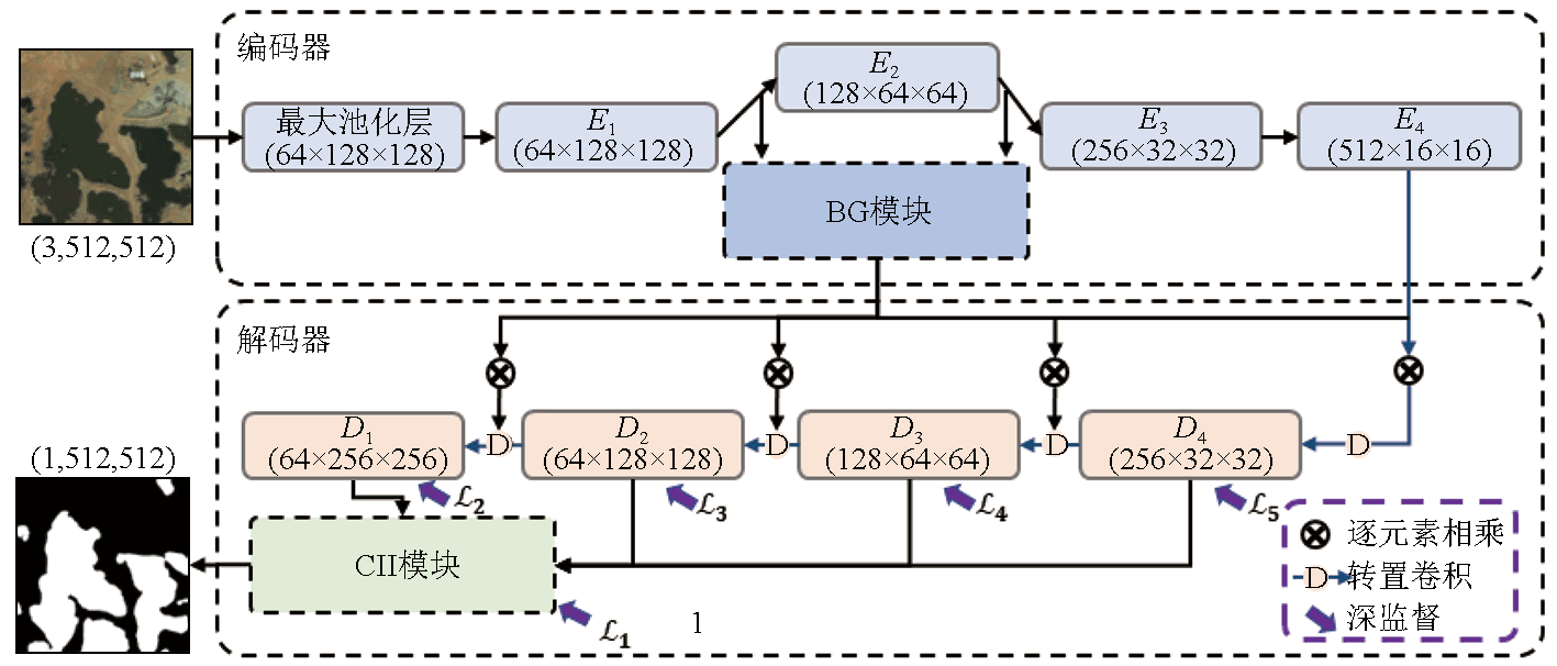
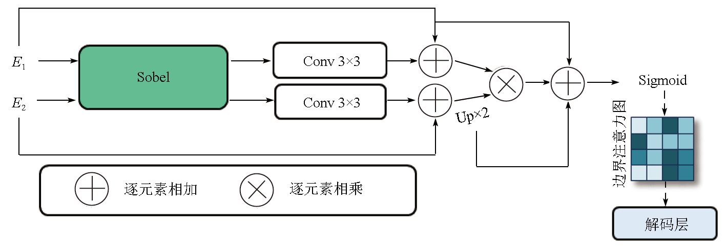
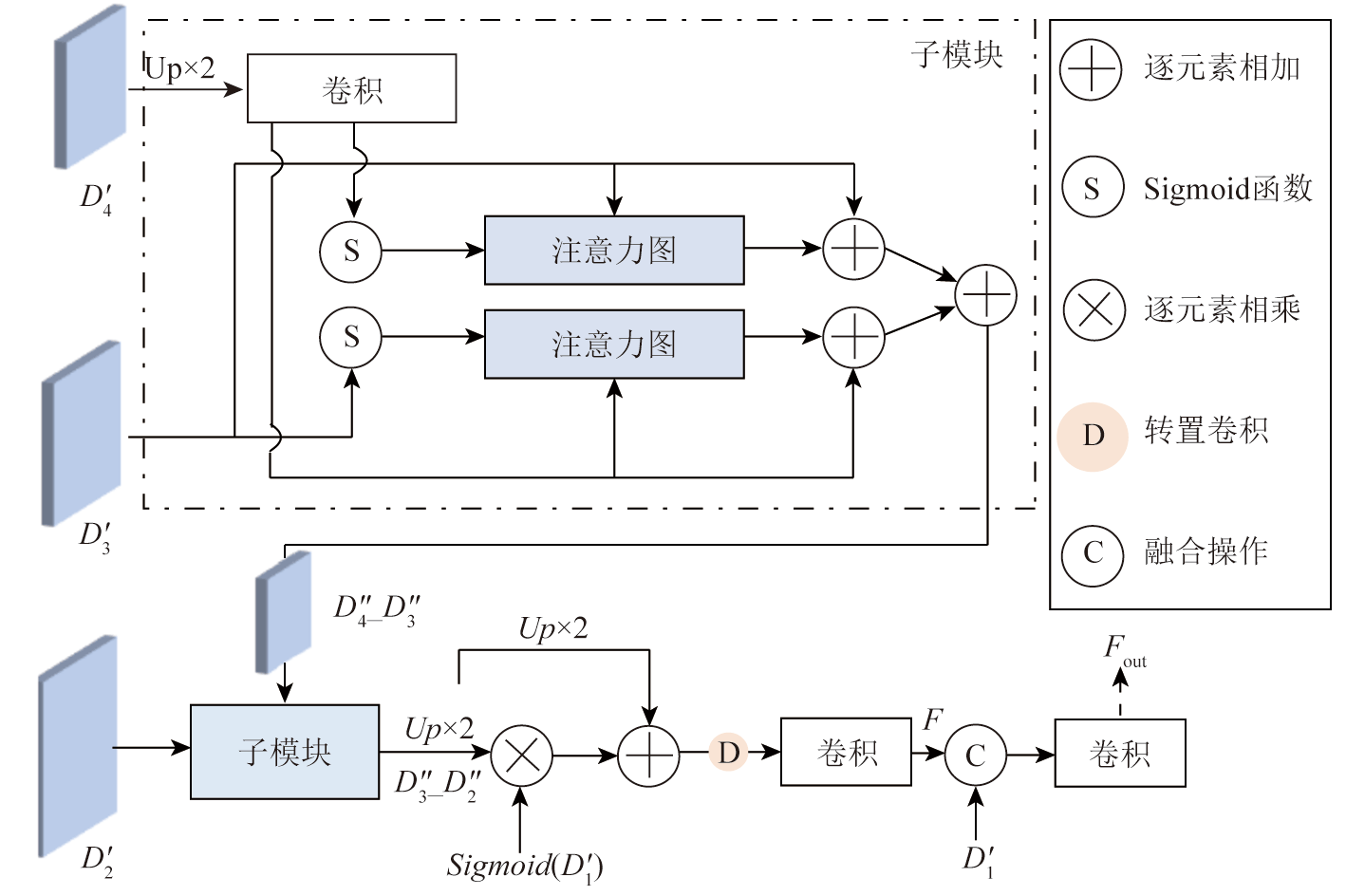
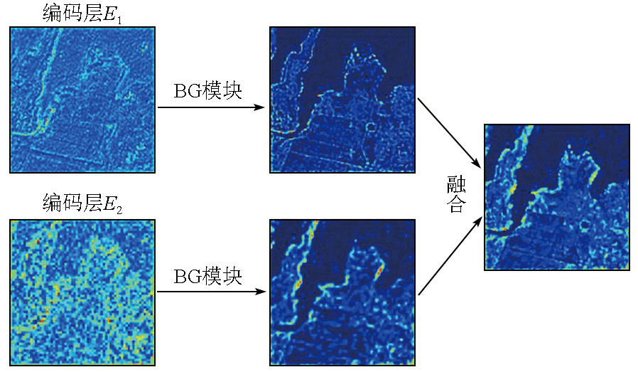
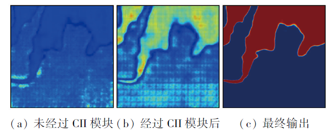
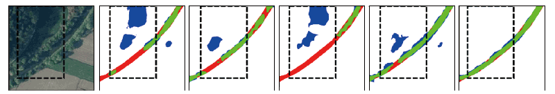
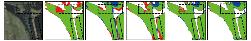
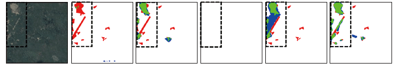
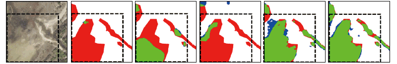
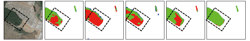
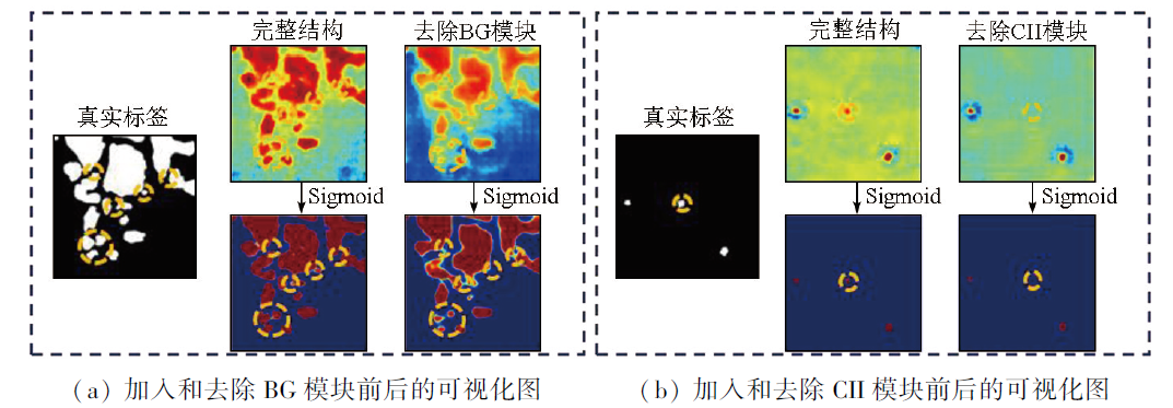
Abstract Extracting accurate water body information holds great significance for water resources protection and urban planning. However, due to numerous surface features and complex environments, along with different morphologies, scales, and spectral characteristics of different water bodies, remote sensing images inevitably exhibit heterogeneity, spectral similarities, and inter-class similarities between water bodies and other surface features. Existing methods fail to fully exploit boundary cues, the semantic correlation between different layers, and multi-scale representations, rendering the accurate information extraction of water bodies from remote sensing images still challenging. This study proposed a boundary guidance and cross-scale information interaction network (BGCIINet) for information extraction of water bodies from remote sensing images. First, this study proposed a boundary guidance (BG) module for the first time by combing the Sobel operator. This module can be used to effectively capture boundary cues in low-level features and efficiently embed these cues into a decoder to produce rich boundary information. Second, a cross-scale information interaction (CII) module was introduced to enhance the multi-scale representation capability of the network and facilitate information exchange between layers. Extensive experiments on two datasets demonstrate that the proposed method outperforms four state-of-the-art methods, offering rich boundary details and completeness under challenging scenarios. Therefore, the proposed method is more effective in extracting water body information from remote sensing images. This study will provide a valuable reference of methods for future research.
|
| Keywords
water body extraction
boundary guidance
cross-scale features
remote sensing images
semantic segmentation
|
|
|
|
Issue Date: 17 February 2025
|
|
|
| [1] |
Wu Z, Lai X, Li K. Water quality assessment of rivers in Lake Chaohu basin (China) using water quality index[J]. Ecological Indicators, 2021,121:107021.
|
| [2] |
杨聪, 童蕾, 马乃进, 等. 洪湖水体和沉积物中抗生素的分布特征及其影响因素研究[J]. 安全与环境工程, 2022, 29(5):78-90.
|
| [2] |
Yang C, Tong L, Ma N J, et al. Distribution characteristics and influencing factors of antibiotics in water and sediments of Honghu Lake[J]. Safety and Environmental Engineering, 2022, 29(5):78-90.
|
| [3] |
Verma U, Chauhan A, M M M P, et al. DeepRivWidth:Deep learning based semantic segmentation approach for river identification and width measurement in SAR images of Coastal Karnataka[J]. Computers & Geosciences, 2021,154:104805.
|
| [4] |
杜云艳, 周成虎. 水体的遥感信息自动提取方法[J]. 遥感学报, 1998, 2(4):264-269.
|
| [4] |
Du Y Y, Zhou C H. Automatically extracting remote sensing information for water body[J]. Journal of Remote Sensing, 1998, 2(4):264-269.
|
| [5] |
Koponen S, Pulliainen J, Kallio K, et al. Lake water quality classification with airborne hyperspectral spectrometer and simulated MERIS data[J]. Remote Sensing of Environment, 2002, 79(1):51-59.
|
| [6] |
McFeeters S K. The use of the normalized difference water index (NDWI) in the delineation of open water features[J]. International Journal of Remote Sensing, 1996, 17(7):1425-1432.
|
| [7] |
Xie C, Huang X, Zeng W, et al. A novel water index for urban high-resolution eight-band WorldView-2 imagery[J]. International Journal of Digital Earth, 2016, 9(10):925-941.
|
| [8] |
Liu Q, Huang C, Shi Z, et al. Probabilistic river water mapping from landsat-8 using the support vector machine method[J]. Remote Sensing, 2020, 12(9):1374.
|
| [9] |
Wang X, Ling F, Yao H, et al. Unsupervised sub-pixel water body mapping with sentinel-3 OLCI image[J]. Remote Sensing, 2019, 11(3):327.
|
| [10] |
Weng L, Xu Y, Xia M, et al. Water areas segmentation from remote sensing images using a separable residual SegNet network[J]. ISPRS International Journal of Geo-Information, 2020, 9(4):256.
|
| [11] |
Guo H, He G, Jiang W, et al. A multi-scale water extraction convolutional neural network (MWEN) method for GaoFen-1 remote sensing images[J].ISPRS International Journal of Geo-Information, 2020, 9(4):189.
|
| [12] |
Li M, Wu P, Wang B, et al. A deep learning method of water body extraction from high resolution remote sensing images with multisensors[J]. IEEE Journal of Selected Topics in Applied Earth Observations and Remote Sensing, 2021,14:3120-3132.
|
| [13] |
Dong S, Pang L, Zhuang Y, et al. Optical remote sensing water-land segmentation representation based on proposed SNS-CNN network[C]// IGARSS 2019-2019 IEEE International Geoscience and Remote Sensing Symposium.July 28 - August 2, 2019, Yokohama,Japan.IEEE,2019:3895-3898.
|
| [14] |
Hu K, Li M, Xia M, et al. Multi-scale feature aggregation network for water area segmentation[J]. Remote Sensing, 2022, 14(1):206.
|
| [15] |
Kang J, Guan H, Peng D, et al. Multi-scale context extractor network for water-body extraction from high-resolution optical remotely sensed images[J]. International Journal of Applied Earth Observation and Geoinformation, 2021,103:102499.
|
| [16] |
Wang Z, Gao X, Zhang Y. HA-net:A lake water body extraction network based on hybrid-scale attention and transfer learning[J]. Remote Sensing, 2021, 13(20):4121.
|
| [17] |
张庆港, 张向军, 余海坤, 等. 一种轻量级网络模型的遥感水体提取方法[J]. 测绘科学, 2022, 47(11):64-72.
|
| [17] |
Zhang Q G, Zhang X J, Yu H K, et al. A water extraction method for remote sensing with lightweight network model[J]. Science of Surveying and Mapping, 2022, 47(11):64-72.
|
| [18] |
Zhang Z, Lu M, Ji S, et al. Rich CNN features for water-body segmentation from very high resolution aerial and satellite imagery[J]. Remote Sensing, 2021, 13(10):1912.
|
| [19] |
沈骏翱, 马梦婷, 宋致远, 等. 基于深度学习语义分割模型的高分辨率遥感图像水体提取[J]. 自然资源遥感, 2022, 34(4):129-135.doi:10.6046/zrzyyg.2021357.
|
| [19] |
Shen J A, Ma M T, Song Z Y, et al. Water information extraction from high-resolution remote sensing images using the deep-learning based semantic segmentation model[J]. Remote Sensing for Natural Resources, 2022, 34(4):129-135.doi:10.6046/zrzyyg.2021357.
|
| [20] |
林娜, 王玉莹, 郭江, 等. 基于SegNet_CRF的遥感影像水体提取方法[J]. 测绘与空间地理信息, 2023, 46(3):12-15,18.
|
| [20] |
Lin N, Wang Y Y, Guo J, et al. A method of water extraction from remote sensing images based on SegNet_CRF[J]. Geomatics & Spatial Information Technology, 2023, 46(3):12-15,18.
|
| [21] |
李红林, 隋百凯, 叶燕萍, 等. 基于语义分割网络的GF-7号卫星数据水体信息提取[J]. 大坝与安全, 2022(4):50-58.
|
| [21] |
Li H L, Sui B K, Ye Y P, et al. Water information extraction from GF-7 satellite data based on semantic segmentation network[J]. Dam & Safety, 2022(4):50-58.
|
| [22] |
刘佳典, 宋伟东, 朱洪波, 等. 改进U-Net模型的遥感影像水体提取研究[J]. 测绘科学, 2022, 47(8):230-239.
|
| [22] |
Liu J D, Song W D, Zhu H B, et al. Research on water extraction from remote sensing images based on improved U-Net model[J]. Science of Surveying and Mapping, 2022, 47(8):230-239.
|
| [23] |
Wang B, Chen Z, Wu L, et al. SADA-net:A shape feature optimization and multiscale context information-based water body extraction method for high-resolution remote sensing images[J]. IEEE Journal of Selected Topics in Applied Earth Observations and Remote Sensing, 2022,15:1744-1759.
|
| [24] |
Boguszewski A, Batorski D, Ziemba-Jankowska N, et al. LandCover.ai:Dataset for automatic mapping of buildings,woodlands,water and roads from aerial imagery[C]//2021 IEEE/CVF Conference on Computer Vision and Pattern Recognition Workshops (CVPRW) June 19-25,2021, Nashville,TN,USA.IEEE,2021:1102-1110.
|
| [25] |
Demir I, Koperski K, Lindenbaum D, et al.DeepGlobe 2018:A challenge to parse the earth through satellite images[C]//2018 IEEE/CVF Conference on Computer Vision and Pattern Recognition Workshops (CVPRW). June 18-22,2018, Salt Lake City,UT,USA.IEEE,2018:172-17209.
|
| [26] |
Oktay O, Schlemper J, Le Folgoc L, et al. Attention U-net:Learning where to look for the pancreas[EB/OL]. 2018:1804.03999.https://arxiv.org/abs/1804.03999v3.
url: https://arxiv.org/abs/1804.03999v3
|
| [27] |
Zhao H, Shi J, Qi X, et al. Pyramid scene parsing network[C]//2017 IEEE Conference on Computer Vision and Pattern Recognition (CVPR) July 21-26,2017, Honolulu,HI,USA.IEEE,2017:6230-6239.
|
| [28] |
Fu J, Liu J, Tian H, et al. Dual attention network for scene segmentation//2019 IEEE/CVF Conference on Computer Vision and Pattern Recognition (CVPR). June 15-20,2019, Long Beach,CA,USA.IEEE,2019:3141-3149.
|
| [29] |
Chen L C, Zhu Y, Papandreou G, et al. Encoder-decoder with atrous separable convolution for semantic image segmentation[M]// Lecture Notes in Computer Science. Cham: Springer International Publishing,2018:833-851.
|
|
Viewed |
|
|
|
Full text
|
|
|
|
|
Abstract
|
|
|
|
|
Cited |
|
|
|
|
| |
Shared |
|
|
|
|
| |
Discussed |
|
|
|
|
 2025,
Vol. 37
2025,
Vol. 37