|
|
 |
|

|
|
|
Monitoring of the area of Poyang Lake based on Landsat images and its relationship with the water level |
ZHAO Hui1( ), CHEN Zhen2, FENG Chaofan1, ZHANG Tong1, ZHAO Xuejing1, ZHANG Zhaoxu3,4() ), CHEN Zhen2, FENG Chaofan1, ZHANG Tong1, ZHAO Xuejing1, ZHANG Zhaoxu3,4() |
1. 248 Geological Brigade of Shandong Nuclear Industry,Qingdao 266041, China
2. Qingdao Survey and Mapping Research Institute, Qingdao, 266033, China
3. School of Environmental Science and Engineering, Tiangong University, Tianjin 300387, China
4. Marine Ecological Restoration and Smart Ocean Engineering Research Center of Hebei Province, Qinhuangdao 066000,China |
|
|
|
|
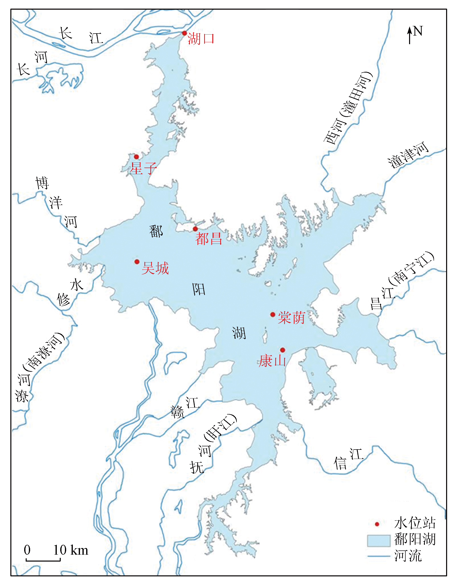
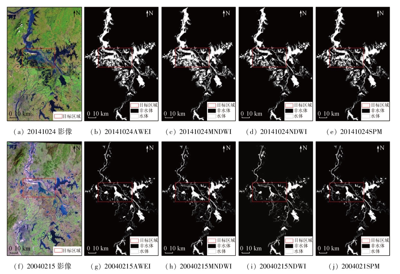
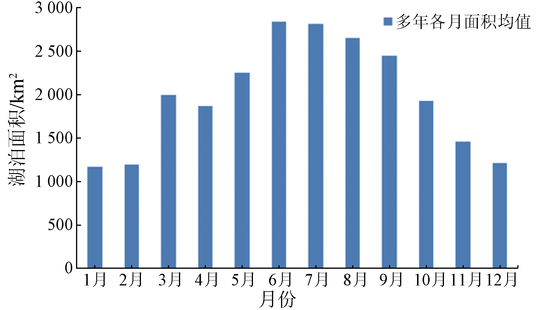
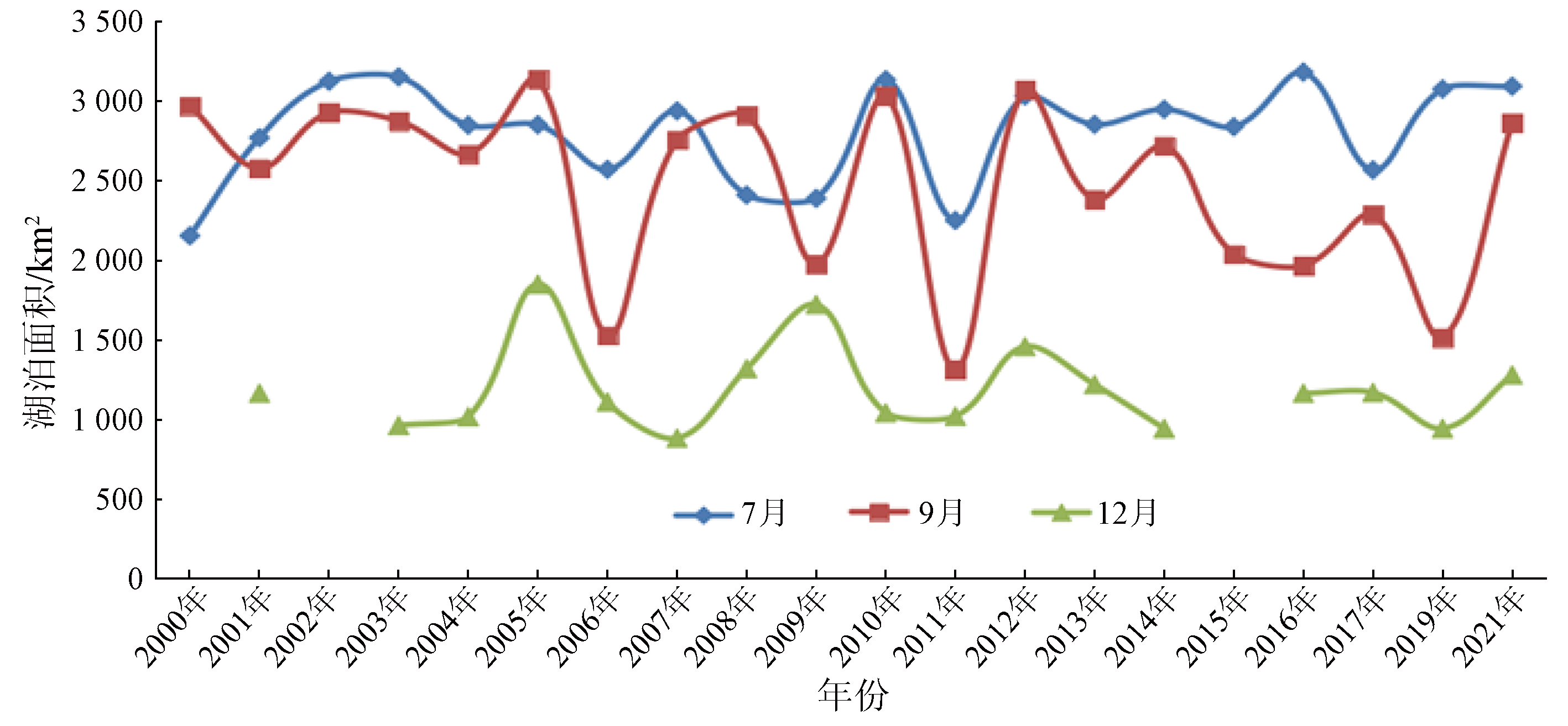
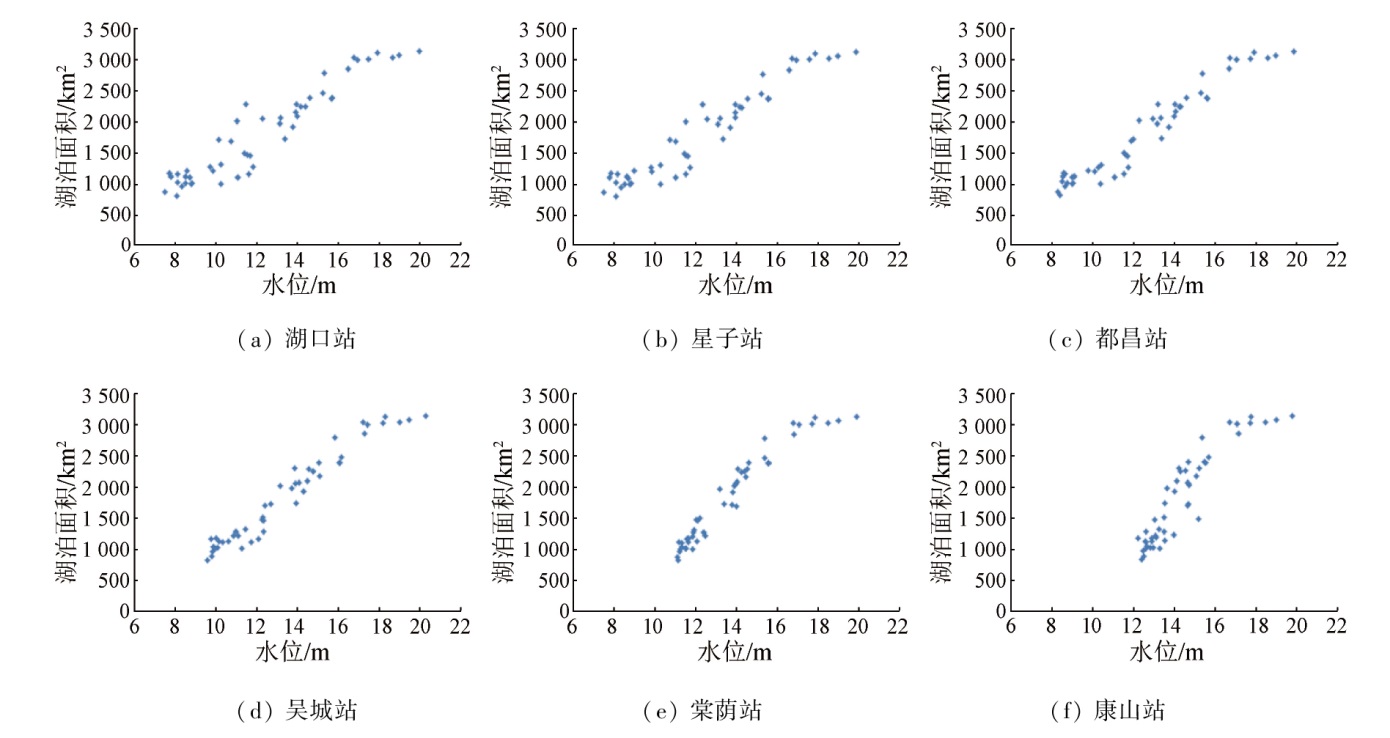
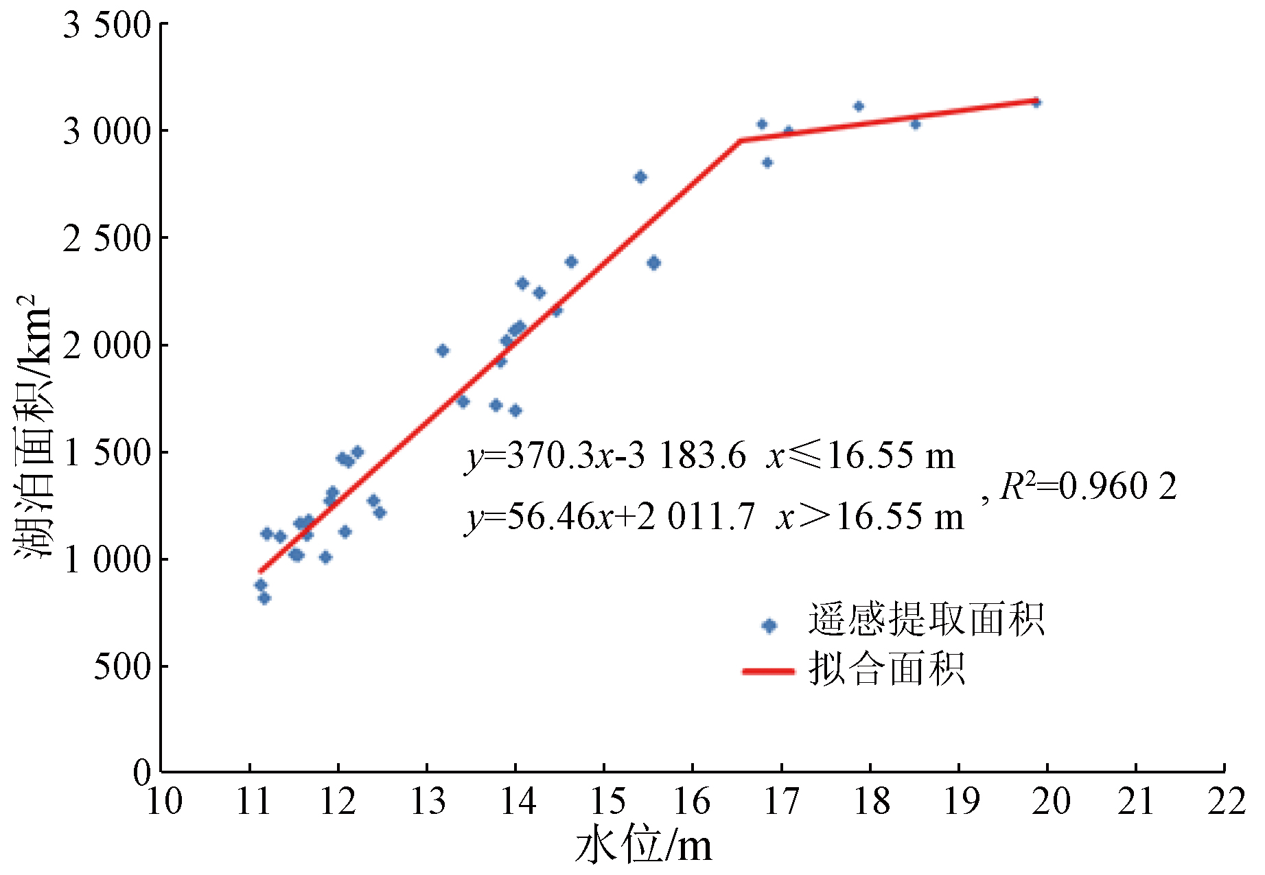
Abstract Lakes constitute a crucial part of terrestrial ecosystems. Changes in the water areas of lakes significantly influence environments and human production activities. Poyang Lake, the largest freshwater lake in China, has experienced many floods and droughts in recent years, thus necessitating its dynamic monitoring. With 175-phase Landsat images of Poyang Lake from 2000 to 2021 as the data source, this study comparatively analyzed four water body extraction methods: the normalized difference water index (NDWI), the modified normalized difference water index (MNDWI), the automated water extraction index (AWEI), and the spectrum photometric method (SPM), determining the optimal water body extraction index for Poyang Lake. Moreover, based on the 175-phase area data, this study delved into the inter-annual area variation trend from 2000 to 2021 as well as the intra-annual seasonal variations. Furthermore, it established the area - water level model by combining 50 sets of water level data from 2009 to 2013 and 2017 to 2018. The results show that: ① The AWEI model, outperforming the other three models in the extraction accuracy, was employed for the water body extraction of Poyang Lake; ② The area of Poyang Lake exhibited significant seasonal variations, large inter-annual fluctuations in the wet season, and relatively gentle inter-annual fluctuations in the dry season; ③ The area - water level piecewise linear model of the Tangyin gauging station proved optimal, which can predict the water coverage area based on real-time water level observations in Poyang Lake, compensating for the limitation of visible spectral remote sensing methods in monitoring the lake water coverage during cloudy and rainy weather.
|
| Keywords
Poyang Lake
Landsat
water body extraction
area variation
area - water level model
|
|
|
|
Issue Date: 14 June 2024
|
|
|
| [1] |
Smith L C, Sheng Y, MacDonald G M, et al. Disappearing Arctic lakes. Science[J]. Science, 2005, 308(5727):1429.
pmid: 15933192
|
| [2] |
孟恺, 石许华, 王二七, 等. 青藏高原中部色林错湖近10年来湖面急剧上涨与冰川消融[J]. 科学通报, 2012, 57(7):571-579.
|
| [2] |
Meng K, Shi X H, Wang E Q, et al. High-altitude salt lake elevation changes and glacial ablation in Central Tibet,2000—2010[J]. Chinese Science Bulletin, 2012, 57(7):571-579.
|
| [3] |
Benson L V, Paillet F L. The use of total lake-surface area as an indicator of climatic change:Examples from the Lahontan basin[J]. Quaternary Research, 1989, 32(3):262-275.
|
| [4] |
张歆牧. 鄱阳湖湿地生态环境评价[D]. 武汉: 华中师范大学, 2008.
|
| [4] |
Zhang X M. Evaluation of the ecological environment of Poyang Lake wetland[D]. Wuhan: Central China Normal University, 2008.
|
| [5] |
闵骞. 近50年鄱阳湖形态和水情的变化及其与围垦的关系[J]. 水科学进展, 2000, 11(1):76-81.
|
| [5] |
Min Q. Study on the relationship between shape,water regime and innings of Poyang Lake[J]. Advances in Water Science, 2000, 11(1):76-81.
|
| [6] |
姜鲁光. 鄱阳湖退田还湖地区洪水风险与土地利用变化研究[D]. 北京: 中国科学院地理科学与资源研究所, 2006.
|
| [6] |
Jiang L G. Flood risk and land use change in the wetland restoration area around Poyang Lake,China[D]. Beijing: Institute of Geographic Sciences and Natural Resources Research, CAS, 2006.
|
| [7] |
Nie Y, Zhang Y, Ding M, et al. Lake change and its implication in the vicinity of Mt.Qomolangma (Everest),central high Himalayas,1970—2009[J]. Environmental Earth Sciences, 2013, 68(1):251-265.
|
| [8] |
Feng L, Hu C M, Chen X L, et al. Satellites capture the drought severity around China’s largest freshwater lake[J]. IEEE Journal of Selected Topics in Applied Earth Observations and Remote Sensing, 2012, 5(4):1266-1271.
|
| [9] |
Carroll M L, Townshend J R G, DiMiceli C M, et al. Shrinking lakes of the Arctic:Spatial relationships and trajectory of change[J]. Geophysical Research Letters, 2011, 38(20):L20406.
|
| [10] |
李景刚, 李纪人, 黄诗峰, 等. 近10年来洞庭湖区水面面积变化遥感监测分析[J]. 中国水利水电科学研究院学报, 2010, 8(3):201-207.
|
| [10] |
Li J G, Li J R, Huang S F, et al. The remote sensing monitoring analysis of Chinese Dongting Lake water area variations in last 10 years using Terra/MODIS data time series[J]. Journal of China Institute of Water Resources and Hydropower Research, 2010, 8(3):201-207.
|
| [11] |
于欢, 张树清, 李晓峰, 等. 基于TM影像的典型内陆淡水湿地水体提取研究[J]. 遥感技术与应用, 2008, 23(3):310-315.
|
| [11] |
Yu H, Zhang S Q, Li X F, et al. Inland limnetic wetlands water body extraction using TM imagery[J]. Remote Sensing Technology and Application, 2008, 23(3):310-315.
|
| [12] |
车向红. 2000—2014年青藏高原湖泊动态遥感监测与分析[D]. 太原: 太原理工大学, 2015.
|
| [12] |
Che X H. Monitoring and analyzing of lake dynamics in Qinghai-Tibet Plateau using remote sensing from 2000 to 2014[D]. Taiyuan: Taiyuan University of Technology, 2015.
|
| [13] |
Sokolov M, Storie J L, Henry C J, et al. Semantically-consistent Landsat8 image to Sentinel-2 image translation for alpine areas[J/OL]. arXiv, 2022 (2022-12-22)[2023-02-20]. https://arxiv.org/abs/2212.12056.
url: https://arxiv.org/abs/2212.12056
|
| [14] |
Zhang G Q, Li J L, Zheng G X, et al. Lake-area mapping in the Tibetan Plateau:An evaluation of data and methods[J]. International Journal of Remote Sensing, 2017, 38(3):742-772.
|
| [15] |
刘东, 李艳. 基于遥感技术的鄱阳湖面积库容估算[J]. 遥感信息, 2012, 27(2):57-61.
|
| [15] |
Liu D, Li Y. The calculation of area and storage of Poyang Lake based on remote sensing technology[J]. Remote Sensing Information, 2012, 27(2):57-61.
|
| [16] |
McFeeters S K. The use of the Normalized Difference Water Index (NDWI) in the delineation of open water features[J]. International Journal of Remote Sensing, 1996, 17(7):1425-1432.
|
| [17] |
Frazier P S, Page K J. Water body detection and delineation with Landsat TM data[J]. Photogrammetric Engineering and Remote Sensing, 2000, 66(12):1461-1467.
|
| [18] |
Olmanson L G, Bauer M E, Brezonik P L. A 20-year Landsat water clarity census of Minnesota’s 10,000 lakes[J]. Remote Sensing of Environment, 2008, 112(11):4086-4097.
|
| [19] |
Fisher A, Flood N, Danaher T. Comparing Landsat water index methods for automated water classification in eastern Australia[J]. Remote Sensing of Environment, 2016, 175:167-182.
|
| [20] |
Li A M, Fan M, Qin G D. Comparative analysis of machine learning algorithms in water extraction[J]. Journal of Physics:Conference Series, 2021, 2076(1):012045.
|
| [21] |
Qin P, Cai Y L, Wang X L. Small waterbody extraction with improved U-net using Zhuhai-1 hyperspectral remote sensing images[J]. IEEE Geoscience and Remote Sensing Letters, 2021, 19:5502705.
|
| [22] |
李辉, 李长安, 张利华, 等. 基于MODIS影像的鄱阳湖湖面积与水位关系研究[J]. 第四纪研究, 2008, 28(2):332-337.
|
| [22] |
Li H, Li C A, Zhang L H, et al. Relationship between water level and water area in Poyang Lake based on MODIS image[J]. Quaternary Sciences, 2008, 28(2):332-337.
|
| [23] |
刘可群, 梁益同, 黄靖, 等. 基于卫星遥感的洞庭湖水体面积变化及影响因子分析[J]. 中国农业气象, 2009, 30(s2):281-284,336.
|
| [23] |
Liu K Q, Liang Y T, Huang J, et al. Analysis of the variations and influencing factors of area in Dongting Lake based on remote sensing satellite[J]. Chinese Journal of Agrometeorology, 2009, 30(s2):281-284,336.
|
| [24] |
张楠楠, 王文, 王胤. 鄱阳湖面积的卫星遥感估计及其与水位关系分析[J]. 遥感技术与应用, 2012, 27(6):947-953.
|
| [24] |
Zhang N N, Wang W, Wang Y. Estimate the area of the Poyang Lake using satellite remote sensing data and analyze its relationship with water level[J]. Remote Sensing Technology and Application, 2012, 27(6):947-953.
|
| [25] |
李鹏, 封志明, 姜鲁光, 等. 鄱阳湖天然湖面遥感监测及其与水位关系研究[J]. 自然资源学报, 2013, 28(9):1556-1568.
doi: 10.11849/zrzyxb.2013.09.011
|
| [25] |
Li P, Feng Z M, Jiang L G, et al. Natural water surface of Poyang Lake monitoring based on remote sensing and the relationship with water level[J]. Journal of Natural Resources, 2013, 28(9):1556-1568.
|
| [26] |
周洋, 张增信, 王言鑫. 鄱阳湖湖泊水位与面积的关系评估[J]. 科技通报, 2015, 31(11):42-47.
|
| [26] |
Zhou Y, Zhang Z X, Wang Y X. Discussion of relationship between water level and area of Poyang Lake[J]. Bulletin of Science and Technology, 2015, 31(11):42-47.
|
| [27] |
Feyisa G L, Meilby H, Fensholt R, et al. Automated water extraction index:A new technique for surface water mapping using Landsat imagery[J]. Remote Sensing of Environment, 2014, 140:23-35.
|
| [28] |
朱宏富, 金锋, 李荣昉. 鄱阳湖调蓄功能与防灾综合治理研究[M]. 北京: 气象出版社, 2002.
|
| [28] |
Zhu H F, Jin F, Li R F. Study on regulation and storage function and comprehensive disaster prevention and control of Poyang Lake[M]. Beijing: China Meteorological Press, 2002.
|
| [29] |
王大钊, 王思梦, 黄昌. Sentinel-2和Landsat8影像的四种常用水体指数地表水体提取对比[J]. 国土资源遥感, 2019, 31(3):157-165.doi:10.6046/gtzyyg.2019.03.20.
|
| [29] |
Wang D Z, Wang S M, Huang C. Comparison of Sentinel-2 imagery with Landsat8 imagery for surface water extraction using four common water indexes[J]. Remote Sensing for Land and Resources, 2019, 31(3):157-165.doi:10.6046/gtzyyg.2019.03.20.
|
| [30] |
寿敬文. 陆地卫星7号ETM+图像数据缺行的修复与应用研究[D]. 哈尔滨: 哈尔滨工程大学, 2006.
|
| [30] |
Shou J W. Research on recovering and application of the Landsat-7 ETM+ SLC-off image[D]. Harbin: Harbin Engineering University, 2006.
|
| [31] |
李国文, 喻中文, 陈家霖. 鄱阳湖动态水位-面积、水位-容积关系研究[J]. 江西水利科技, 2015, 41(1):21-26,34.
|
| [31] |
Li G W, Yu Z W, Chen J L. Study on the relationship between dynamic level-area and level-volume of Poyang Lake[J]. Jiangxi Hydraulic Science & Technology, 2015, 41(1):21-26,34.
|
| [32] |
曾少龙. 基于EFDC模型的鄱阳湖水位与湖面面积关系分析[D]. 南昌: 江西师范大学, 2018.
|
| [32] |
Zeng S L. Analysis of the relationship between water level and lake surface area of Poyang Lake based on EFDC model[D]. Nanchang: Jiangxi Normal University, 2018.
|
| [33] |
蔡晓斌. 主被动遥感辅助下的鄱阳湖水位时空动态及洲滩变化研究[D]. 武汉: 武汉大学, 2010.
|
| [33] |
Cai X B. The change analysis of water stage and beach wetland in Poyang Lake with the aid of multi-temporal active and passive remote sensing data[D]. Wuhan: Wuhan University, 2010.
|
| [34] |
徐涵秋. 利用改进的归一化差异水体指数(MNDWI)提取水体信息的研究[J]. 遥感学报, 2005, 9(5):589-595.
|
| [34] |
Xu H Q. A Study on information extraction of water body with the modified normalized difference water index(MNDWI)[J]. Journal of Remote Sensing, 2005, 9(5):589-595.
|
| [35] |
杜云艳, 周成虎. 水体的遥感信息自动提取方法[J]. 遥感学报, 1998, 2(4):264-269.
|
| [35] |
Du Y Y, Zhou C H. Automatically extraction remote sensing information for water bodies[J]. Journal of Remote Sensing, 1998, 2(4):264-269.
|
|
Viewed |
|
|
|
Full text
|
|
|
|
|
Abstract
|
|
|
|
|
Cited |
|
|
|
|
| |
Shared |
|
|
|
|
| |
Discussed |
|
|
|
|
 2024,
Vol. 36
2024,
Vol. 36