|
|
 |
|

|
|
|
A method for field inspection of natural resource surveys using UAV-based geographic information video technology |
WANG Yunkai1( ), LI Anmin1, LIN Nan2, CAO Yijie3 ), LI Anmin1, LIN Nan2, CAO Yijie3 |
1. Jiangsu Institute of Surveying and Mapping of Geology, Nanjing 211102, China
2. China MCC17 Group Co., Ltd., Maanshan 243000, China
3. Jiangsu Tuojia Engineering Design and Research Co., Ltd., Nanjing 211100,China |
|
|
|
|
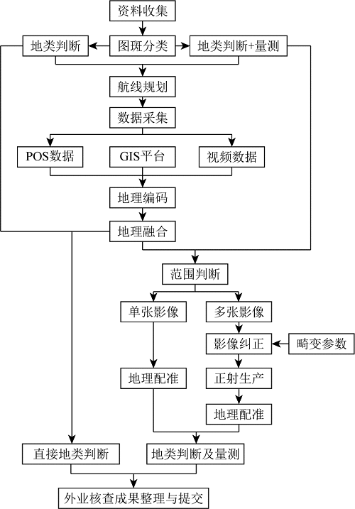
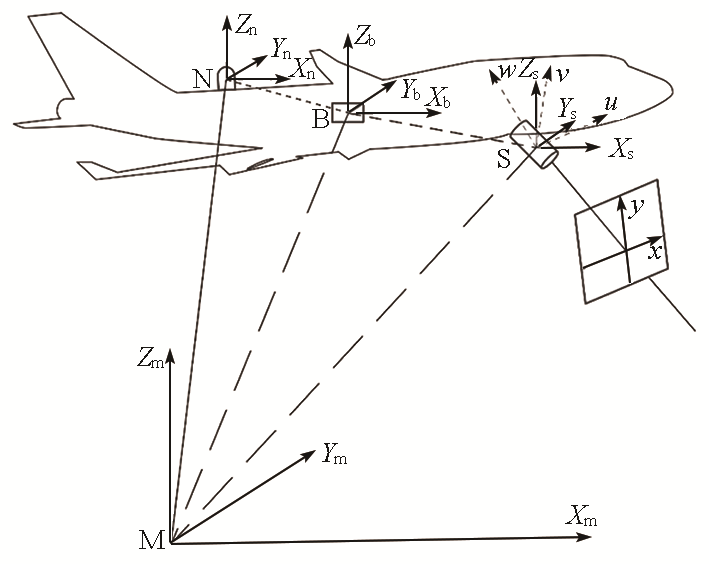
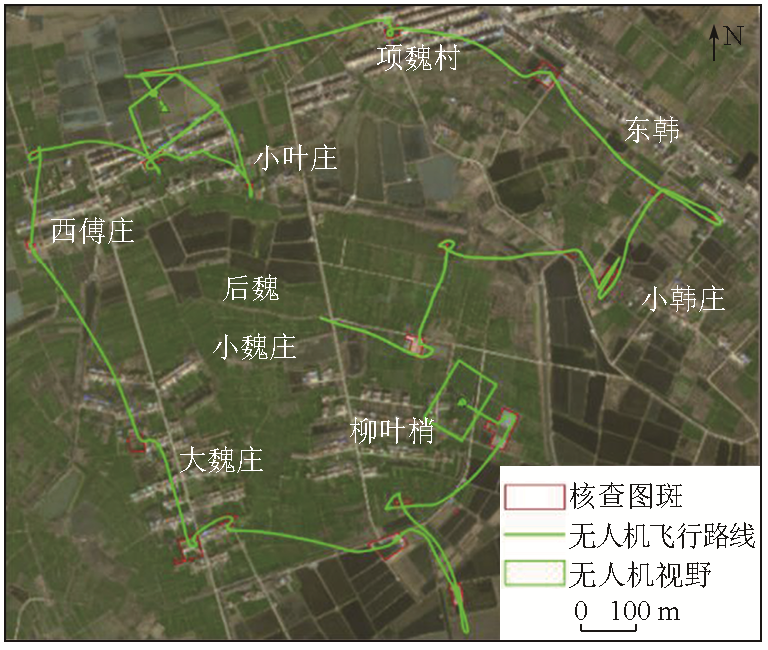
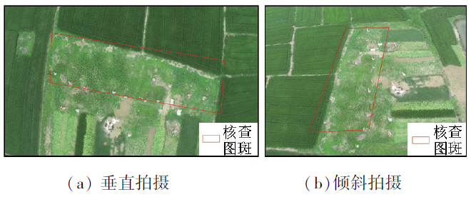
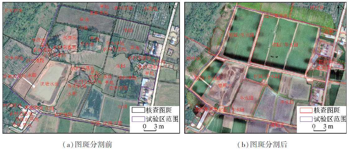
Abstract Field verification of natural resources is a vital part of natural resource surveys. To address issues such as low efficiency and security risks encountered in traditional field verification methods, this study developed an application scheme for field verification utilizing UAV-based geographic information video technology. First, this study examined the characteristics of UAV-based geographic information video technology. Based on these characteristics, as well as the requirements of field verification, the features for the field verification were categorized into two types: land use classification and measurement assessment. Subsequently, the UAV-based geographic information video acquisition was designed for each type. The collected videos were then combined with a geographic information system (GIS) platform for feature evaluation and measurement. The application scheme was tested based on production practices. The test results indicate that the proposed scheme can improve the efficiency of the field inspection, with the measurement accuracy meeting the demand for actual production needs. Furthermore, the scheme can overcome the limitations of ground-based photography and reduce safety risks.
|
| Keywords
UAV
field verification
natural resource surveys
geographic information video
|
|
|
|
Issue Date: 17 February 2025
|
|
|
| [1] |
聂玉文, 王欢欢, 符太成, 等. 国土空间规划下用地分类体系探究[J]. 住宅与房地产, 2019(19): 73-74.
|
| [1] |
Nie Y W, Wang H H, Fu T C, et al. Study on land classification system under land spatial planning[J]. Housing and Real Estate, 2019(19): 73-74.
|
| [2] |
杨笑尘. 土地变更调查外业核查系统设计与实现[D]. 西安: 长安大学, 2018.
|
| [2] |
Yang X C. Design and implementation of land change survey field verification system[D]. Xi’an: Changan University, 2018.
|
| [3] |
钟娜娜, 宗恒康, 胡振彪, 等. 第三次全国国土调查外业核查系统设计与实现[J]. 城市勘测, 2020(6): 38-42.
|
| [3] |
Zhong N N, Zong H K, Hu Z B, et al. Design and implementation of the third national land survey field verification system[J]. Urban Geotechnical Investigation and Surveying, 2020(6): 38-42.
|
| [4] |
陈德权. 微服务架构的自然资源外业核查系统设计与实现[J]. 地理空间信息, 2021, 19(5): 123-126, 6.
|
| [4] |
Chen D Q. Design and implementation of natural resource field verification system based on microservice architecture[J]. Geospatial Information, 2021, 19(5): 123-126, 6.
|
| [5] |
孙新博, 李英成, 王凤, 等. 无人机地理信息视频系统的设计与实现[J]. 测绘科学, 2018, 43(10): 131-136, 156.
|
| [5] |
Sun X B, Li Y C, Wang F, et al. Design and implementation of UAV geographic information video system[J]. Science of Surveying and Mapping, 2018, 43(10): 131-136, 156.
|
| [6] |
王磊, 周鑫鑫, 吴长彬. 无人机实时视频与三维地理场景融合[J]. 测绘通报, 2021(12): 33-37, 43.
doi: 10.13474/j.cnki.11-2246.2021.368
|
| [6] |
Wang L, Zhou X X, Wu C B. Fusion method of UAV real-time video and 3D geographical scene[J]. Bulletin of Surveying and Mapping, 2021(12): 33-37, 43.
doi: 10.13474/j.cnki.11-2246.2021.368
|
| [7] |
孟静, 王凤, 李玉琳, 等. 应急测绘视频帧与GIS系统匹配技术[J]. 遥感信息, 2022, 37(2): 91-96.
|
| [7] |
Meng J, Wang F, Li Y L, et al. Matching technology between emergency mapping video frame and GIS system[J]. Remote Sensing Information, 2022, 37(2): 91-96.
|
| [8] |
任丽艳, 李英成, 肖金城, 等. 测绘无人机灾害现场多源数据集成与智能服务[J]. 测绘科学, 2020, 45(12): 139-144.
|
| [8] |
Ren L Y, Li Y C, Xiao J C, et al. Multi-source data integration and intelligent service of surveying and mapping UAV for disaster scene[J]. Science of Surveying and Mapping, 2020, 45(12): 139-144.
|
| [9] |
陈光, 郑宏伟. 三维场景中无人机地理视频数据的集成方法[J]. 地理与地理信息科学, 2017, 33(1): 40-43, 72.
|
| [9] |
Chen G, Zheng H W. Integration method of UAV GeoVideo data model in 3D scene[J]. Geography and Geo-Information Science, 2017, 33(1): 40-43, 72.
|
| [10] |
张雪萍. POS辅助航空摄影测量直接对地目标定位的关键技术研究[D]. 武汉: 武汉大学, 2010.
|
| [10] |
Zhang X P. Research on key technologies of direct georeferencing in POS-supported aerial photogrammetry[D]. Wuhan: Wuhan University, 2010.
|
| [11] |
王佩军, 徐亚明. 摄影测量学: 测绘工程专业[M]. 3版. 武汉: 武汉大学出版社, 2016.
|
| [11] |
Wang P J, Xu Y M. Geo-spatial information science[M]. 3rd ed. Wuhan: Wuhan University Press, 2016.
|
| [12] |
姚娜. 低空无人机载组合宽角相机关键技术研究与性能分析[D]. 武汉: 武汉大学, 2013.
|
| [12] |
Yao N. Research on key technologies of low altitude UAV borne multi-head and wide-angle composite cameras and their performance evaluation[D]. Wuhan: Wuhan University, 2013.
|
| [13] |
王贤. 基于POS系统的数字正射影像制作研究[D]. 绵阳: 西南科技大学, 2018.
|
| [13] |
Wang X. Research on making digital orthophoto map based on position and orientation system[D]. Mianyang: Southwest University of Science and Technology, 2018.
|
| [14] |
叶晴旻. 大视场相机畸变校正相关技术的研究[D]. 杭州: 浙江大学, 2016.
|
| [14] |
Ye Q M. Research on related technology of correction of distortion of the large view camera[D]. Hangzhou: Zhejiang University, 2016.
|
| [15] |
李彤彤. 双目视觉系统的标定及畸变校正技术研究[D]. 长春: 吉林大学, 2019.
|
| [15] |
Li T T. Research on calibration and distortion correction technique of binocular vision system[D]. Changchun: Jilin University, 2019.
|
| [16] |
樊敏, 秦健, 李云响, 等. ArcGIS数字化地质图校正及配准[J]. 化工矿产地质, 2014, 36(3): 185-189.
|
| [16] |
Fan M, Qin J, Li Y X, et al. ArcGIS digital geological map correction and registration[J]. Geology of Chemical Minerals, 2014, 36(3): 185-189.
|
| [17] |
李伟. 基于数字视频数据的地理信息提取与空间分析研究[D]. 焦作: 河南理工大学, 2015.
|
| [17] |
Li W. Geographic information extracting and spatial analysis based on video data[D]. Jiaozuo: Henan Polytechnic University, 2015.
|
| [18] |
王凯. 一种无人机铁路巡线视频定位方法[J]. 科技和产业, 2022, 22(1): 323-328.
|
| [18] |
Wang K. A location method for UAV railway patrol video[J]. Science Technology and Industry, 2022, 22(1): 323-328.
|
|
Viewed |
|
|
|
Full text
|
|
|
|
|
Abstract
|
|
|
|
|
Cited |
|
|
|
|
| |
Shared |
|
|
|
|
| |
Discussed |
|
|
|
|
 2025,
Vol. 37
2025,
Vol. 37