|
|
 |
|

|
|
|
Study on distribution of thermal discharge in Fuqing nuclear power plant based on Landsat8 and UAV |
DONG Shuangfa1,2( ), FAN Xiao3, SHI Haigang1,2(), XU Liping3, ZHANG Xinyi1,2 ), FAN Xiao3, SHI Haigang1,2(), XU Liping3, ZHANG Xinyi1,2 |
1. Airborne Survey and Remote Sensing Center of Nuclear Industry, Shijiazhuang 050002, China
2. Hebei Key Laboratory of Airborne Detection and Remote Sensing Technology, Shijiazhuang 050002, China
3. Fujian Fuqing Nuclear Power Co., Ltd., Fuzhou 350318, China |
|
|
|
|
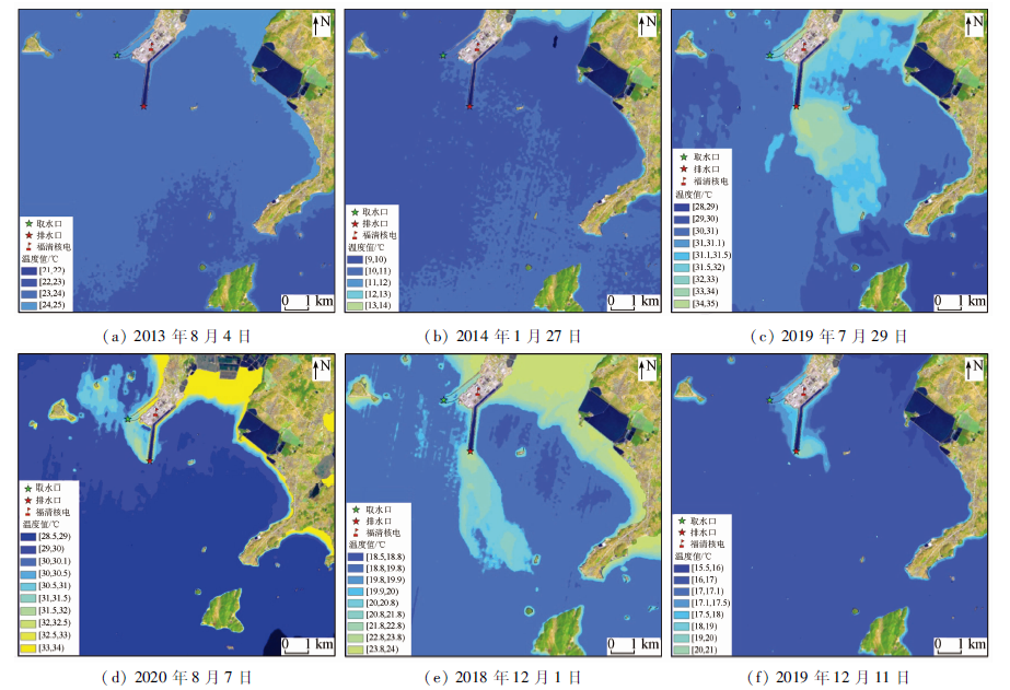
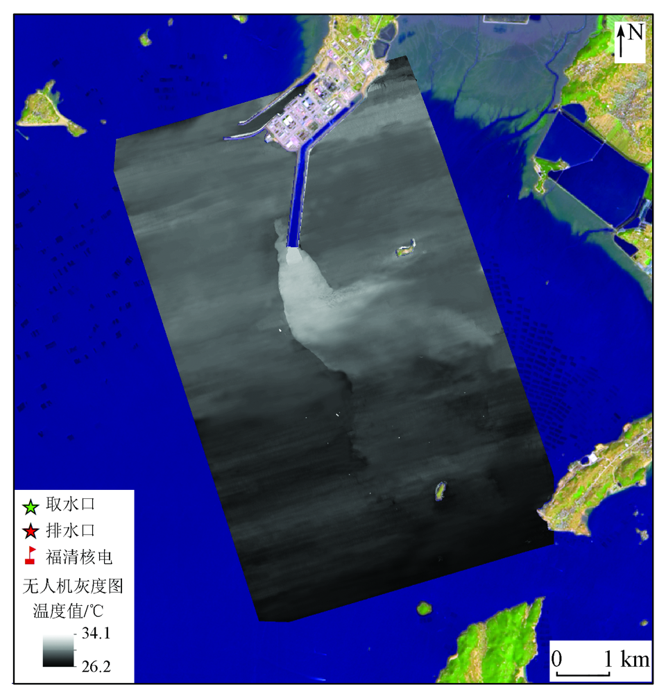
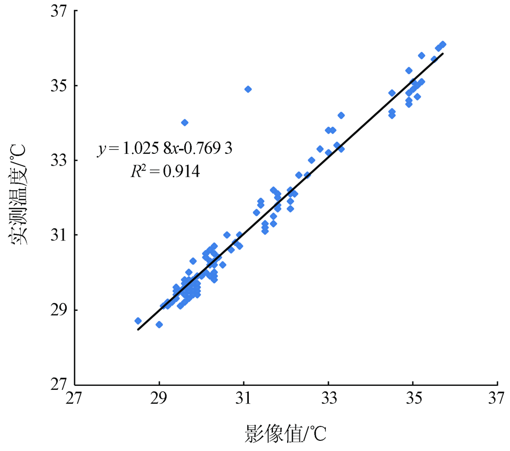
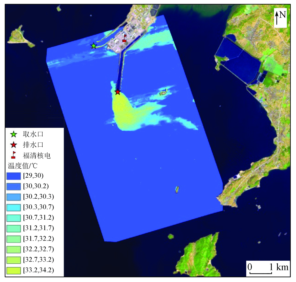
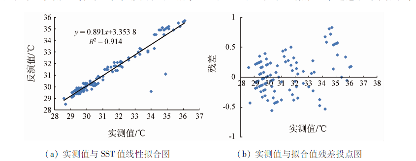
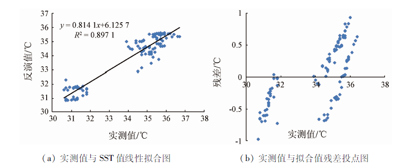
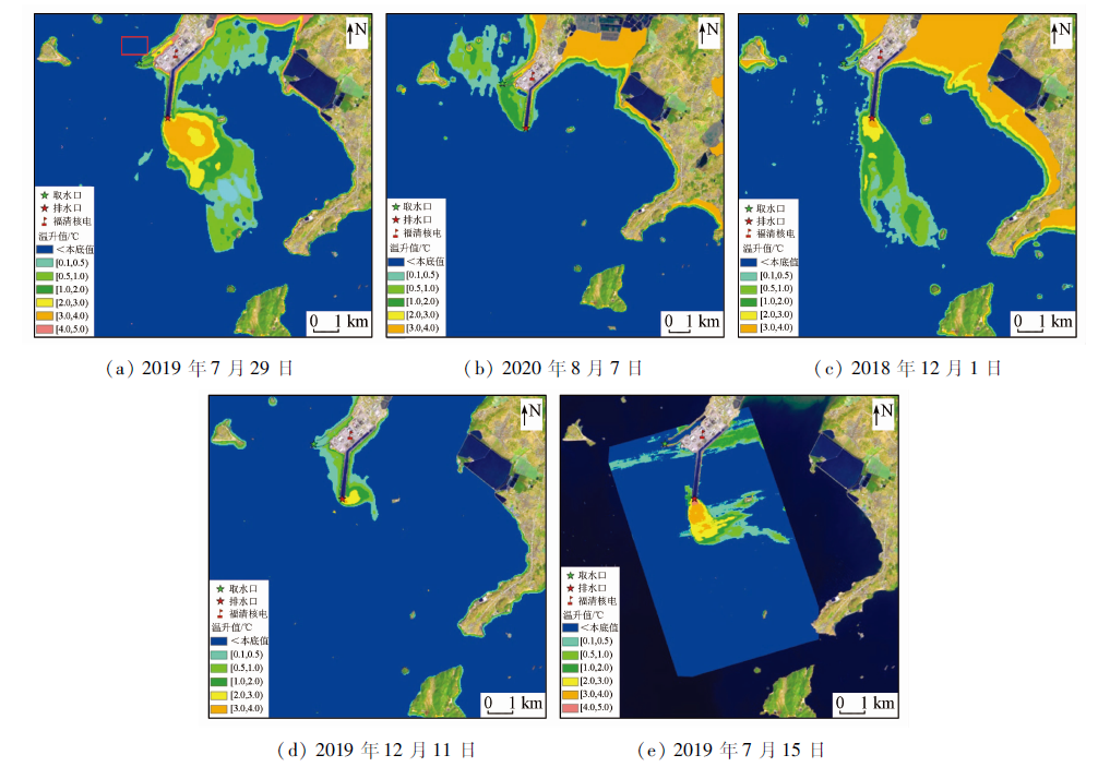
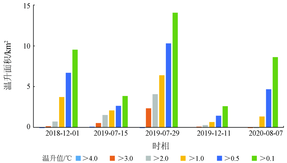
Abstract Based on the thermal infrared data from the Landsat8 satellite and a UAV, this study obtained the spatial distribution of the temperature of the sea area near the Fuqing Nuclear Power Plant through inversion. Then, this study verified the reliability of the inversion results using the measured temperature data and investigated the distribution and variation characteristics of the temperature field in the sea area near the power plant. The results are as follows. The inversion results of the temperature are strongly correlated with the measured offshore temperature data and thereby are reliable. Before the nuclear power plant was put into operation, the temperature of the sea area near the nuclear power plant was relatively uniform, without significant temperature differentiation or temperature rise. By contrast, after the nuclear power plant was put into operation, significant temperature differentiation occurred in the surrounding sea area because of the thermal discharge. Moreover, the spatial distribution of thermal discharge and its scale varied greatly under different tides and seasons. Generally, the temperature rise range was wider under ebb tides than under flood tides and was wider in summer than in winter.
|
| Keywords
Landsat8
UAV
temperature inversion
thermal discharge from nuclear power plant
remote sensing-based monitoring
|
|
|
|
Corresponding Authors:
SHI Haigang
E-mail: 13643218698@163.com;383071766@qq.com
|
|
Issue Date: 21 September 2022
|
|
|
| [1] |
陈晓秋, 商照荣. 核电厂环境影响审查中的温排水问题[J]. 核安全, 2007(2):46-50.
|
| [1] |
Chen X Q, Shang Z R. The issue of thermal discharge in reviewing the environmental impacts report for nuclear power plant[J]. Nuclear Saftey, 2007(2):46-50.
|
| [2] |
於凡, 张永兴. 滨海核电站温排水对海洋生态系统影响的研究[J]. 辐射防护通讯, 2008, 28(1):1-7.
|
| [2] |
Yu F, Zhang Y X. The review on the effects of thermal effluent from nuclear plants on the marine ecosystem[J]. Radiation Protection Communication, 2008, 28(1):1-7.
|
| [3] |
刘永叶, 陈晓秋. 核电厂温排水热影响研究的建议[J]. 辐射防护通讯, 2011, 31(6):20-23.
|
| [3] |
Liu Y Y, Chen X Q. Suggestion of the study on thermal impact of thermal discharge from NPPs[J]. Radiation Protection Communication, 2011, 31(6):20-23.
|
| [4] |
姜晟, 李俊龙, 李旭文. 核电站温排水遥感监测方法研究——以田湾核电站为例[J]. 中国环境监测, 2013, 29(6):46-50.
|
| [4] |
Jiang S, Li J L, Li X W. A research on the remote sensing monitoring method with the thermal discharge of Tianwan nuclear power station[J]. Environmental Monitoring in China, 2013, 29(6):46-50.
|
| [5] |
姚沛林. 滨海核电厂温排水的监测与实践[J]. 红外, 2013, 34(11):43-48.
|
| [5] |
Yao P L. Monitoring of warm water discharged from coastal nuclear power station[J]. Infrared, 2013, 34(11):43-48.
|
| [6] |
贺佳惠, 梁春利, 李名松. 核电站近岸温度场航空热红外遥感测量数据处理研究[J]. 国土资源遥感, 2010, 85(3):51-53.doi: 10.6046/gtzyyg.2010.03.11.
doi: 10.6046/gtzyyg.2010.03.11
|
| [6] |
He J H, Liang C L, Li M S. Temperature field airborne thermal remote sensing survey of the alongshore nuclear power station[J]. Remote Sensing for Land and Resources, 2010, 85(3):51-53.doi: 10.6046/gtzyyg.2010.03.11.
doi: 10.6046/gtzyyg.2010.03.11
|
| [7] |
Jimenez-Munoz J C, Sobrino J A. A generalized single-channel method for retrieving land surface temperature from remote sensing data[J]. Journal of Geophysical Research Atmospheres, 2003, 108(D22): 1-9.
|
| [8] |
Qin Z H, Karnieli A, Berliner A. A mono-window algorithm for retrieving land surface temperature from Landsat TM and its application to the Israel-Egypt border region[J]. Remote Sensing, 2001, 22:3719-3746.
|
| [9] |
Price J C. Land surface temperature measurements from the split window channels of the NOAA7 advanced very high resolution radiometer[J]. Journal of Geophysical Research, 1984, 89(d5):231-237.
|
| [10] |
吴传庆, 王桥, 王文杰. 利用TM影像监测和评价大亚湾温排水热污染[J]. 中国环境监测, 2006, 22(3):80-84.
|
| [10] |
Wu C Q, Wang Q, Wang W J. Monitoring and evaluation of thermal pollution of thermal discharge in Daya Bay using TM images[J]. China Environmental Monitoring, 2006, 22 (3):80-84.
|
| [11] |
朱利. 基于环境一号红外相机的田湾核电站温排水遥感监测研究[J]. 中国环境科学, 32(s1):63-67.
|
| [11] |
Zhu L. Study on remote sensing monitoring of temperature and drainage of Tianwan nuclear power station based on environment-1 infrared camera[J]. China Environmental Science, 32 (s1):63-67.
|
| [12] |
王祥, 苏岫, 王新新. 基于Landsat8卫星数据的红沿河核电站温排水监测[J]. 红外, 2015, 36(8):22-27.
|
| [12] |
Wang X, Su X, Wang X X. Thermal drainage monitoring of Hongyanhe nuclear power station based on Landsat8 satellite data[J]. Infrared, 2015, 36 (8):22-27.
|
| [13] |
于杰, 李永振, 陈丕茂. 利用Landsat TM6 数据反演大亚湾海水表层温度[J]. 国土资源遥感, 2009, 21(3):24-29.doi: 10.6046/gtzyyg.2009.03.05.
doi: 10.6046/gtzyyg.2009.03.05
|
| [13] |
Yu J, Li Y Z, Chen P M. Retrieval of sea surface temperature in Daya Bay using Landsat TM6 data[J]. Remote Sensing for Land and Research, 2009, 21(3):24-29.doi: 10.6046/gtzyyg.2009.03.05.
doi: 10.6046/gtzyyg.2009.03.05
|
| [14] |
许静, 朱利, 姜建. 基于HJ-1B与TM热红外数据的大亚湾核电基地温排水遥感监测[J]. 中国环境科学, 2014, 34(5):1181-1186.
|
| [14] |
Xu J, Zhu Li, Jiang J. Remote sensing monitoring of temperature and drainage of Daya Bay nuclear power base based on HJ-1B and TM thermal infrared data[J]. China Environmental Science, 2014, 34 (5):1181-1186.
|
| [15] |
孙芹芹, 张加晋, 姬厚德. 基于卫星和无人机的后石电厂温排水分布研究[J]. 应用海洋学学报, 2020, 39(2):261-265.
|
| [15] |
Sun Q Q, Zhang J J, Ji H D. Distribution of thermal water around Houshi Power Plant based on Landsat8 and UVA study[J]. Journal of Applied Oceanography, 2020, 39 (2):261-265.
|
| [16] |
王祥, 王新新, 苏岫. 无人机平台航空遥感监测核电站温排水——以辽宁省红沿河核电站为例[J]. 国土资源遥感, 2018, 30(4):182-186.doi: 10.6046/gtzyyg.2018.04.27.
doi: 10.6046/gtzyyg.2018.04.27
|
| [16] |
Wang X, Wang X X, Su X. Thermal discharge monitoring of nuclear power plant with aerial remote sensing technology using a UAV platform:Take Hongyanhe Nuclear Power Plant,Liaoning Province,as example[J]. Remote Sensing for Land and Resources, 2018, 30 (4):182-186.doi: 10.6046/gtzyyg.2018.04.27.
doi: 10.6046/gtzyyg.2018.04.27
|
| [17] |
初庆伟, 张洪群, 吴业炜, 等. Landsat8卫星数据应用探讨[J]. 遥感信息, 2013, 28(4):110-114.
|
| [17] |
Chu Q W, Zhang H Q, Wu Y W, et al. Application research of Landsat8[J]. Remote Sensing Information, 2013, 28(4):110-114.
|
| [18] |
陈瀚阅, 朱利, 李家国, 等. 基于Landsat8数据的2种海表温度反演单窗算法对比——以红沿河核电基地海域为例[J]. 国土资源遥感, 2018, 30(1):45-53.doi: 10.6046/gtzyyg.2018.01.07.
doi: 10.6046/gtzyyg.2018.01.07
|
| [18] |
Chen H Y, Zhu L, Li J G, et al. A comparison of two mono-window algorithm for retrieving sea surface temperature from Landsat8 data in coastal water of Hongyan River nuclear power station[J]. Remote Sensing for Land and Resources, 2018, 30(1):45-53.doi: 10.6046/gtzyyg.2018.01.07.
doi: 10.6046/gtzyyg.2018.01.07
|
| [19] |
Rozenstein. Derivation of land surface temperature for Landsat8 TIRS using a split window algorithm[J]. Sensors, 2014, 14(14):5768-5780.
doi: 10.3390/s140405768
url: http://www.mdpi.com/1424-8220/14/4/5768
|
| [20] |
覃志豪. 用陆地卫星TM6数据演算地表温度的单窗算法[J]. 地理学报, 2001, 56(4):456-466.
doi: 10.11821/xb200104009
|
| [20] |
Qin Z H. Mono-window algorithm for retrieving land surface temperature from Landsat TM6 data[J]. Acta Geographica Sinica, 2001, 56(4): 456-466.
doi: 10.11821/xb200104009
|
| [21] |
Barsi J A, Barker J L, Schott J R. An atmospheric correction parameter calculator for a single thermal band earth-sensing instrument[C]// IGARSS, 2003:3014-3016.
|
| [22] |
Barsi J A, Schott J R, Palluconi F D, et al. Validation of a web-based atmospheric correction tool for single thermal band instruments[Z]. Earth Observing Systems X, 2005, 5882:1-6.
|
| [23] |
耿娟, 何成龙, 刘宪鑫. 基于CSIFT特性的无人机影像匹配[J]. 国土资源遥感, 2016, 28(1):93-100.doi: 10.6046/gtzyyg.2016.01.14.
doi: 10.6046/gtzyyg.2016.01.14
|
| [23] |
Geng J, He C L, Liu X X. UAV image matching based on CSIFT feature[J]. Remote Sensing for Land and Resources, 2016, 28 (1):93-100.doi: 10.6046/gtzyyg.2016.01.14.
doi: 10.6046/gtzyyg.2016.01.14
|
| [24] |
王雅萍, 陈宜金, 谢东海, 等. 面向无人机水域影像的自动拼接方法[J]. 长江科学院院报, 2014, 31(5):92-96.
|
| [24] |
Wang Y P, Chen Y J, Xie D H, et al. Automatic mosaic method for UAV water-area image[J]. Journal of the Yangtze River Sciences Research Institute, 2014, 31(5):92-96.
|
| [25] |
福清5、6号机组运行阶段环评专题——温排水数值模拟复核研究报告[R]. 中国水利水电科学研究院, 2018, 4:7-11.
|
| [25] |
Special topic of environmental impact assessment during operation of No.5 and No.6 nuclear power units of Fuqing nuclear power - review research report on numerical simulation of thermal discharge[R]. China Institute of Water Resources and Hydropower Research, 2018, 4:7-11.
|
|
Viewed |
|
|
|
Full text
|
|
|
|
|
Abstract
|
|
|
|
|
Cited |
|
|
|
|
| |
Shared |
|
|
|
|
| |
Discussed |
|
|
|
|
 2022,
Vol. 34
2022,
Vol. 34