|
|
|
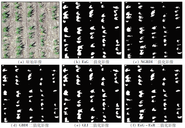
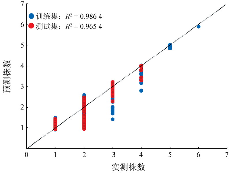
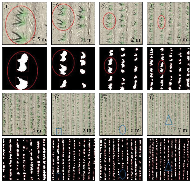
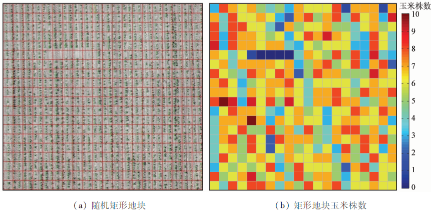
Abstract To monitor and evaluate maize seedlings in Northeast China and estimate their number in time, this study provided effective support for the rapid estimation of the maize seedling number using unmanned aerial vehicle (UAV) remote sensing images. Using the multispectral UAV data, the color indexes ExG, GBDI, ExG-ExR, NGRDI, and GLI were compared to segment maize seedlings from the soil background. Then, the optimal threshold was determined using the Otsu algorithm, and ExG was selected as the optimal color index. According to optimization, the best combination of morphological parameters consists of area (A), perimeter (B), rectangle length (D), rectangle perimeter (G), ellipse long axis length (H), and shape factor (Q). Then, the number of maize seedlings was predicted using the support vector regression (SVR) model and the prediction accuracy was assessed. Finally, the spatial distribution map of the local maize seedling number was developed. Tests revealed that the accuracy and the statistical error of the SVR model were 96.54% and 0.6%, respectively. These results allow the number and growth trends of maize seedlings to be predicted quickly and accurately in a short time.
|
| Keywords
UAV
seedling number
support vector regression (SVR)
color index
|
|
|
|
Corresponding Authors:
HUANG Yang
E-mail: 614639191@qq.com;1875818447@qq.com
|
|
Issue Date: 14 March 2022
|
|
|
| [1] |
Liu P, Guo W S, Xu Y M, et al. Effect of planting density on grain yield and quality of weak gluten and medium-gluten wheat[J]. Journal of Triticeae Crops, 2006, 26:117-121.
|
| [2] |
葛朝红, 孟建朝, 赵海龙. 影响棉花出苗的因素分析[J]. 现代农村科技, 2011(18):13.
|
| [2] |
Ge C H, Meng J C, Zhao H L. Analysis of factors affecting cotton emergence[J]. Modern Rural Science and Technology, 2011(18):13.
|
| [3] |
胡健波, 张健. 无人机遥感在生态学中的应用进展[J]. 生态学报, 2018, 38(1):20-30.
|
| [3] |
Hu J B, Zhang J. Unmanned aerial vehicle remote sensing in ecology:Advances and prospects[J]. Acta Ecologica Sinica, 2018, 38(1):20-30.
|
| [4] |
戴建国, 张国顺, 郭鹏, 等. 基于无人机遥感多光谱影像的棉花倒伏信息提取[J]. 农业工程学报, 2019, 35(2):63-70.
|
| [4] |
Dai J G, Zhang G S, Guo P, et al. Information extraction of cotton lodging based on multi-spectral image from UAV remote sensing[J]. Transactions of the Chinese Society of Agricultural Engineering, 2019, 35(2):63-70.
|
| [5] |
Mitch B, Reid A, Ramos F, et al. Airbornevision based mapping and classification of large farmland environments[J]. Journal of Field Robotics, 2010, 27(5):632-655.
doi: 10.1002/rob.20343
url: https://onlinelibrary.wiley.com/doi/10.1002/rob.20343
|
| [6] |
丁雷龙, 李强子, 杜鑫, 等. 基于无人机图像颜色指数的植被识别[J]. 自然资源遥感, 2016, 28(1):78-86.doi: 10.6046/gtzyyg.2016.01.12.
doi: 10.6046/gtzyyg.2016.01.12
|
| [6] |
Ding L L, Li Q Z, Du X, et al. Vegetation extraction method based on color indices from UAV images[J]. Remote Sensing for Land and Resources, 2016, 28(1):78-86.doi: 10.6046/gtzyyg.2016.01.12.
doi: 10.6046/gtzyyg.2016.01.12
|
| [7] |
汪小钦, 王苗苗, 王绍强, 等. 基于可见光波段无人机遥感的植被信息提取[J]. 农业工程学报, 2015, 31(5):152-159.
|
| [7] |
Wang X Q, Wang M M, Wang S Q, et a1. Extraction of vegetation information from visible unmanned aerial vehicle images[J]. Transactions of the Chinese Society of Agricultural Engineering, 2015, 31(5):152-159.
|
| [8] |
兰玉彬, 邓小玲, 曾国亮. 无人机农业遥感在农作物病虫草害诊断应用研究进展[J]. 智慧农业, 2019, 1(2):1-19.
|
| [8] |
Lan Y B, Deng X L, Zeng G L. Advances in diagnosis of crop diseases,pests and weeds by UAV remote sensing[J]. Smart Agriculture, 2019, 1(2):1-19.
|
| [9] |
Zheng X L, Zhang X F, Cheng J Y, et al. Using the multispectral image data acquired by unmanned aerial vehicle to build an estimation model of the number of seedling stage cotton plants[J]. Journal of Image and Graphics, 2020, 25(3):520-534.
|
| [10] |
戴建国, 薛金利, 赵庆展, 等. 利用无人机可见光遥感影像提取棉花苗情信息[J]. 农业工程学报, 2020, 36(4):63-71.
|
| [10] |
Dai J G, Xue J L, Zhao Q Z, et al. Extraction of cotton seedling growth information using UAV visible light remote sensing images[J]. Transactions of the Chinese Society of Agricultural Engineering, 2020, 36(4):63-71.
|
| [11] |
刘帅兵, 杨贵军, 周成全, 等. 基于无人机遥感影像的玉米苗期株数信息提取[J]. 农业工程学报, 2018, 34(22):69-77.
|
| [11] |
Liu S B, Yang G J, Zhou C Q, et al. Extraction of maize seedling number information based on UAV imagery[J]. Transactions of the Chinese Society of Agricultural Engineering, 2018, 34(22):69-77.
|
| [12] |
Zhao B, Zhang J, Yang C H, et al. Rapeseed seedling stand counting and seeding performance evaluationat two early growth stages based on unmanned aerial vehicle imagery[J]. Frontiers in Plant Science, 2018, 9:1362.
doi: 10.3389/fpls.2018.01362
url: https://www.frontiersin.org/article/10.3389/fpls.2018.01362/full
|
| [13] |
Han L, Yang G J, Dai H Y, et al. Modeling maize above-ground biomass based on machine learning approaches using UAV remote-sensing data[J]. Plant Methods, 2019, 15(1):10.
doi: 10.1186/s13007-019-0394-z
url: https://doi.org/10.1186/s13007-019-0394-z
|
| [14] |
Woebbecke D M, Meyer G E, Bargen K V, et al. Color indices for weed identification under various soil,residue,and lighting conditions[J]. Transactions of the ASABE, 1995, 38(1):259-269.
|
| [15] |
Verrelst J, Schaepman M E, Koetz B, et al. Angular sensitivity analysis of vegetation indices derived from CHRIS/PROBA data[J]. Remote Sensing of Environment, 2008, 112(5):2341-2353.
doi: 10.1016/j.rse.2007.11.001
url: https://linkinghub.elsevier.com/retrieve/pii/S0034425707004683
|
| [16] |
Motohka T, Nasahara K N, Oguma H, et al. Applicability of green-red vegetation index for remote sensing of vegetation phenology[J]. Remote Sensing, 2010, 2(10):2369-2387.
doi: 10.3390/rs2102369
url: http://www.mdpi.com/2072-4292/2/10/2369
|
| [17] |
Liu G R, Huang Z, Mao S C, et al. Application study about OTSU optimal threshold method in cotton seedling recognition[J]. Cotton Science, 2013, 25(1):86-89.
|
| [18] |
刘广瑞, 黄真, 毛树春, 等. OTSU最佳阈值法在棉花幼苗识别中的应用研究[J]. 棉花学报, 2013, 25(1):86-89.
|
| [18] |
Liu G R, Huang Z, Mao S C, et al. Application study about OTSU optimal threshold method in cotton seedling recognition[J]. Cotton Science, 2013, 25(1):86-89.
|
| [19] |
Otsu N. A threshold selection method from gray-level histograms[J]. IEEE Transactions on Systems,Man and Cybernetics, 1979, 9(1):62-66.
doi: 10.1109/TSMC.1979.4310076
url: http://ieeexplore.ieee.org/document/4310076/
|
| [20] |
Pal M. Kernel methods in remote sensing:A review[J]. ISH Journal of Hydraulic Engineering, 2009:15194-15215.
|
| [21] |
Bakhshipour A, Jafari A. Evaluation of support vector machine and artificial neural networks in weed detection using shape features[J]. Computers and Electronics in Agriculture, 2018, 145:153-160.
doi: 10.1016/j.compag.2017.12.032
url: https://linkinghub.elsevier.com/retrieve/pii/S0168169917301333
|
| [22] |
Zheng Y, Zhu Q B, Huang M, et al. Maize and weed classification using color indices with support vector data description in outdoor fields[J]. Computers and Electronics in Agriculture, 2017, 141:215-222.
doi: 10.1016/j.compag.2017.07.028
url: https://linkinghub.elsevier.com/retrieve/pii/S0168169917301096
|
|
Viewed |
|
|
|
Full text
|
|
|
|
|
Abstract
|
|
|
|
|
Cited |
|
|
|
|
| |
Shared |
|
|
|
|
| |
Discussed |
|
|
|
|
 2022,
Vol. 34
2022,
Vol. 34
 ), HUANG Yang1(