|
|
 |
|

|
|
|
Land subsidence caused by groundwater level recovery in Taiyuan City |
TANG Wei1( ), YAN Zhuangzhuang2, WANG Yiming1(), XU Fangfang1, WU Xuanyu1 ), YAN Zhuangzhuang2, WANG Yiming1(), XU Fangfang1, WU Xuanyu1 |
1. School of Geoscience and Surveying Engineering, China University of Mining and Technology (Beijing), Beijing 100083, China
2. State Key Laboratory of Information Engineering in Surveying, Mapping and Remote Sensing, Wuhan University, Wuhan 430079, China |
|
|
|
|
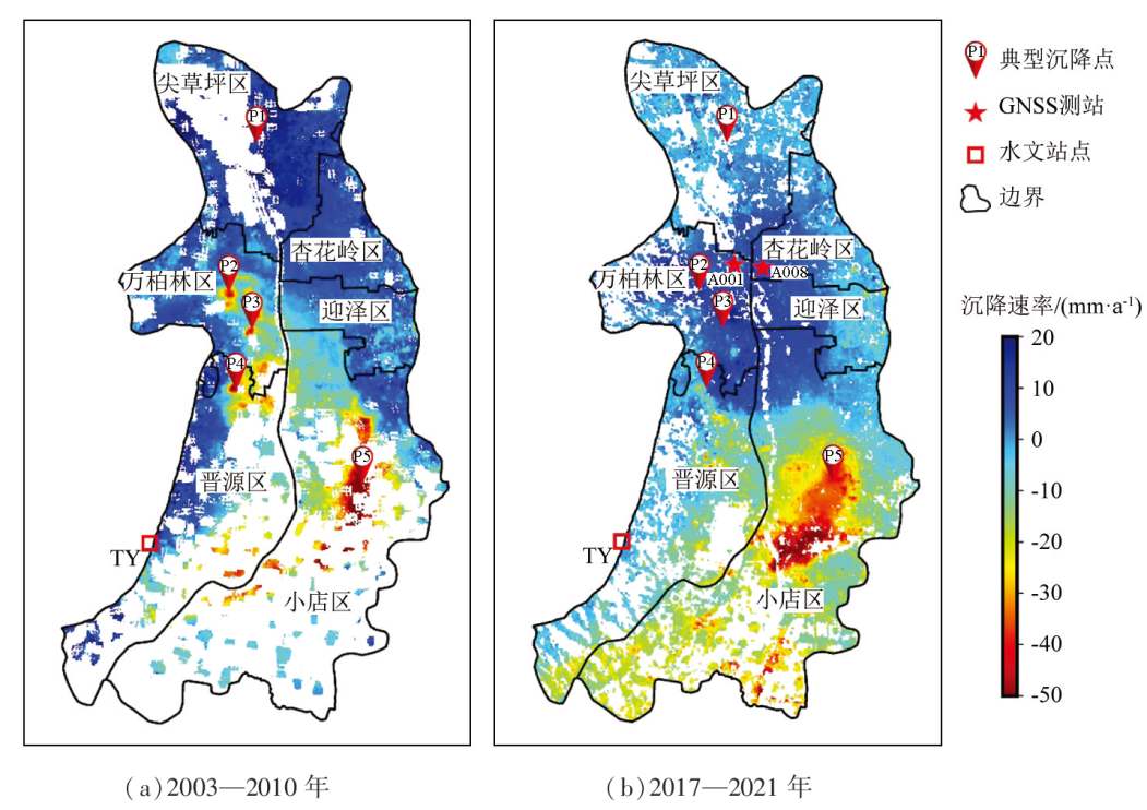
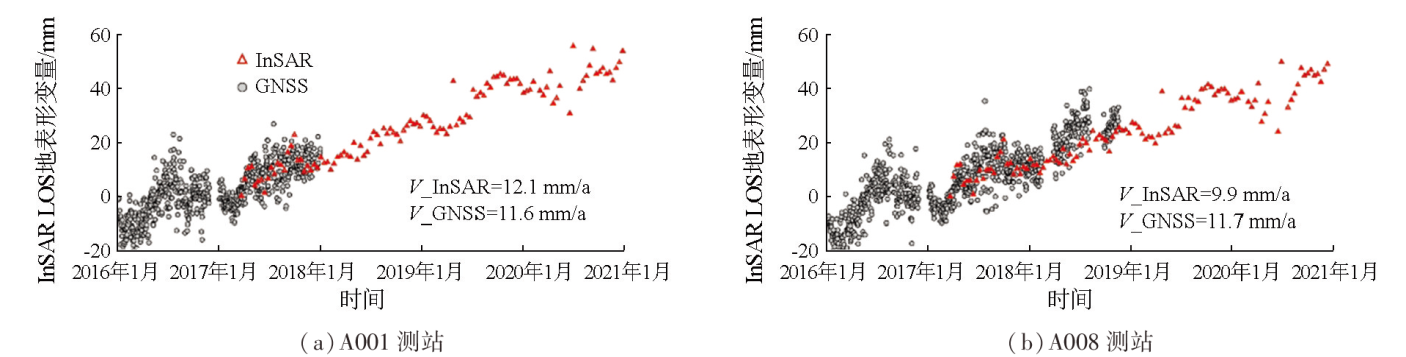
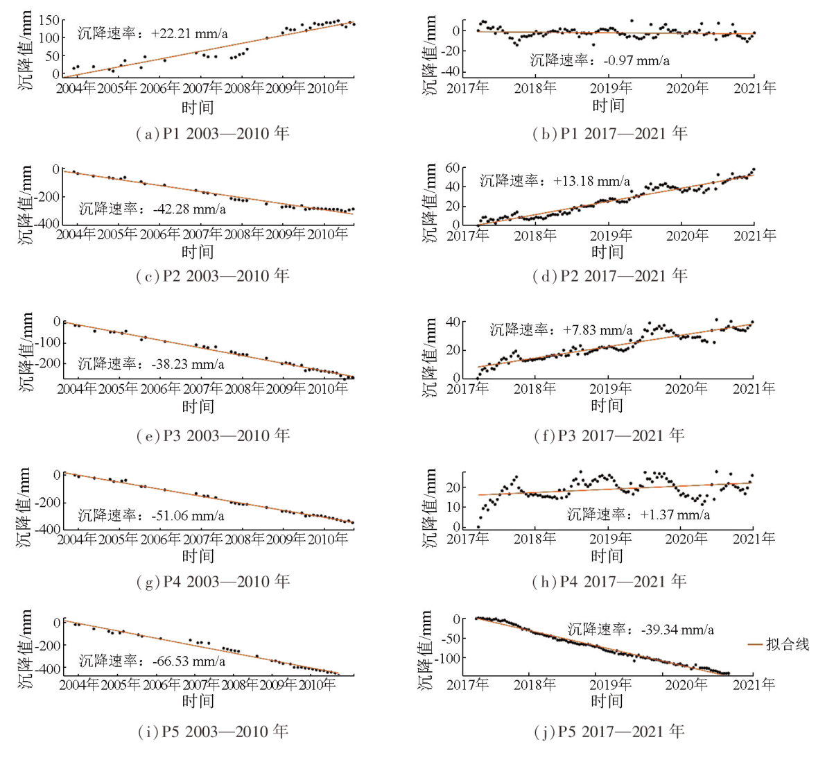
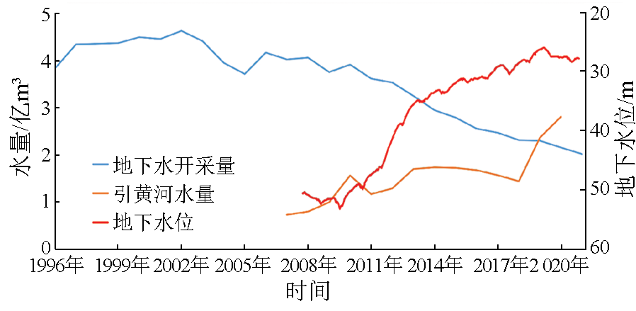
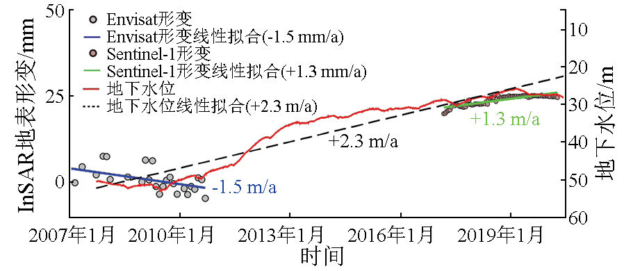
Abstract Over the past few decades, excessive groundwater exploitation has led to a significant decrease in the groundwater level and serious land subsidence in Taiyuan City. In recent years, Taiyuan has vigorously implemented strict groundwater management measures and the project of water diversion into Shanxi from the Yellow River, substantially alleviating groundwater overexploitation and gradually recovering groundwater levels in the city. Therefore, it is necessary to scientifically assess the effect of groundwater level revovery on land subsidence. Based on 2003—2010 synthetic aperture radar (SAR) data from ENVISAT and 2017—2021 SAR data from Sentinel-1, this study extracted the land subsidence information of Taiyuan City of both periods using persistent scatterer interferometric SAR (PS-INSAR). Accordingly, this study compared and analyzed the temporal evolution of land subsidence during the two periods by combining the groundwater extraction volumes, water volumes diverted from the water diversion project, and data on groundwater levels. The results show that the land subsidence in Taiyuan City has been significantly mitigated, with the urban area having shifted from subsidence to uplift. In the Xiaodian area, which underwent the most serious land subsidence, the subsidence area expanded. Nevertheless, the overall land subsidence rate decreased, and the subsidence center has moved southward. The main cause for the slowdown of the land subsidence and even the land uplift in Taiyuan is the continuous groundwater level recovery attributed to the reduced groundwater exploitation and the water diversion project. The results of this study provide a scientific basis for fine-scale land subsidence prevention and groundwater management in Taiyuan City under conditions of groundwater level recovery.
|
| Keywords
land subsidence
subsidence rate
time series
groundwater
spatiotemporal evolvement
|
|
|
|
Issue Date: 09 May 2025
|
|
|
| [1] |
山西省水利厅. 山西省特大干旱年应急水源规划[M]. 北京: 中国水利水电出版社, 2009.
|
| [1] |
Water Resources Department of Shanxi Province. Emergency water source planning in severe drought year in Shanxi Province[M]. Beijing: China Water and Power Press, 2009.
|
| [2] |
孙晓涵, 彭建兵, 崔向美, 等. 山西太原盆地地裂缝与地下水开采、地面沉降关系分析[J]. 中国地质灾害与防治学报, 2016, 27(2):91-98.
|
| [2] |
Sun X H, Peng J B, Cui X M, et al. Relationship between ground fissures,groundwater exploration and land subsidence in Taiyuan Basin[J]. The Chinese Journal of Geological Hazard and Control, 2016, 27(2):91-98.
|
| [3] |
孙自永, 马腾, 马军, 等. 太原市地层空间异质性对地面沉降分布的影响[J]. 岩土力学, 2007, 28(2):399-403,408.
|
| [3] |
Sun Z Y, Ma T, Ma J, et al. Effect of strata heterogeneity on spatial pattern of land subsidence in Taiyuan City[J]. Rock and Soil Mechanics, 2007, 28(2):399-403,408.
|
| [4] |
周艳萍. 太原市地面沉降发展概况及其危害[J]. 经济研究导刊, 2017(30):190-191,195.
|
| [4] |
Zhou Y P. General situation and harm of land subsidence in Taiyuan City[J]. Economic Research Guide, 2017(30):190-191,195.
|
| [5] |
崔振东, 唐益群. 国内外地面沉降现状与研究[J]. 西北地震学报, 2007(3): 275-278,292.
|
| [5] |
Cui Z D, Tang Y Q. Domestic and international recent situation and research of land subsidence disasters[J]. China Earthquake Engineering Journal, 2007(3):275-278,292.
|
| [6] |
史珉, 宫辉力, 陈蓓蓓, 等. Sentinel-1A京津冀平原区2016—2018年地面沉降InSAR监测[J]. 自然资源遥感, 2021, 33(4):55-63.doi:10.6046/zrzyyg.2020341.
|
| [6] |
Shi M, Gong H L, Chen B B, et al. Monitoring of land subsidence in Beijing-Tianjin-Hebei Plain during 2016—2018 based on InSAR and Sentinel-1A data[J]. Remote Sensing for Natural Resources, 2021, 33(4):55-63.doi:10.6046/zrzyyg.2020341.
|
| [7] |
于文, 宫辉力, 陈蓓蓓, 等. 北京东部平原区地面沉降时空演化特征及预测[J]. 自然资源遥感, 2022, 34(4):183-193.doi:10.6046/zrzyyg.2021390.
|
| [7] |
Yu W, Gong H L, Chen B B, et al. Spatial-temporal evolution characteristics and prediction of land subsidence in the eastern plain of Beijing[J]. Remote Sensing for Natural Resources, 2022, 34(4):183-193.doi:10.6046/zrzyyg.2021390.
|
| [8] |
唐伟, 赵祥君, 康彩琴, 等. 太原盆地地面沉降时序InSAR监测与季节性变形小波分析[J]. 地球物理学报, 2023, 66(6): 2352-2369.
|
| [8] |
Tang W, Zhao X J, Kang C Q, et al. Monitoring land subsidence by time series InSAR and wavelet analysis of seasonal deformation in Taiyuan Basin[J]. Chinese Journal of Geophysics, 2023, 66(6):2352-2369.
|
| [9] |
Ferretti A, Prati C, Rocca F. Permanent scatterers in SAR interferometry[J]. IEEE Transactions on Geoscience and Remote Sensing, 2001, 39(1):8-20.
|
| [10] |
李德仁, 廖明生, 王艳. 永久散射体雷达干涉测量技术[J]. 武汉大学学报(信息科学版), 2004, 29(8): 664-668.
|
| [10] |
Li D R, Liao M S, Wang Y. Progress of permanent scatterer interferometry[J]. Geomatics and Information Science of Wuhan University, 2004(8): 664-668.
|
| [11] |
Ferretti A, Prati C, Rocca F. Nonlinear subsidence rate estimation using permanent scatterers in differential SAR interferometry[J]. IEEE Transactions on Geoscience and Remote Sensing, 2000, 38(5):2202-2212.
|
| [12] |
Lanari R, Mora O, Manunta M, et al. A small-baseline approach for investigating deformations on full-resolution differential SAR interferograms[J]. IEEE Transactions on Geoscience and Remote Sensing, 2004, 42(7):1377-1386.
|
| [13] |
Berardino P, Fornaro G, Lanari R, et al. A new algorithm for surface deformation monitoring based on small baseline differential SAR interferograms[J]. IEEE Transactions on Geoscience and Remote Sensing, 2002, 40(11): 2375-2383.
|
| [14] |
Hooper A, Segall P, Zebker H. Persistent scatterer interferometric synthetic aperture radar for crustal deformation analysis,with application to Volcán Alcedo,Galápagos[J]. Journal of Geophysical Research:Solid Earth, 2007, 112(B7):B07407.
|
| [15] |
Hilley G E, Bürgmann R, Ferretti A, et al. Dynamics of slow-moving landslides from permanent scatterer analysis[J]. Science, 2004, 304(5679):1952-1955.
pmid: 15218146
|
| [16] |
杨国华, 江在森, 刘广余, 等. 华北地区的水平运动场与昆仑山8.1级地震的可能关系[J]. 大地测量与地球动力学, 2007, 27(2):10-15.
|
| [16] |
Yang G H, Jiang Z S, Liu G Y, et al. Possible relation of horizontal movement field in North China to Kunlun Mountain Ms8.1 earthquake[J]. Journal of Geodesy and Geodynamics, 2007, 27(2):10-15.
|
| [17] |
Perissin D, Ferretti A. Urban-target recognition by means of repeated spaceborne SAR images[J]. IEEE Transactions on Geoscience and Remote Sensing, 2007, 45(12):4043-4058.
|
| [18] |
方鹏飞, 朱向荣, 武胜忠. 太原市地面沉降的计算与预测[J]. 煤田地质与勘探, 2002, 30(4):44-46.
|
| [18] |
Fang P F, Zhu X R, Wu S Z. Computation and prediction of the land subsidence in Taiyuan[J]. Coal Geology and Exploration, 2002, 30(4):44-46.
|
| [19] |
董少刚, 刘白薇, 唐仲华. 太原市地面沉降数值模拟[J]. 水资源保护, 2010, 26(6): 19-22,36.
|
| [19] |
Dong S G, Liu B W, Tang Z H. Numerical simulation of land subsidence of Taiyuan City[J]. Water Resources Protection, 2010, 26(6):19-22,36.
|
| [20] |
吴宏安, 张永红, 陈晓勇, 等. 基于小基线DInSAR技术监测太原市2003—2009年地表形变场[J]. 地球物理学报, 2011, 54(3): 673-680.
|
| [20] |
Wu H A, Zhang Y H, Chen X Y, et al. Ground deformation monitoring using small baseline DInSAR technique:A case study in Taiyuan City from 2003 to 2009[J]. Chinese Journal of Geophysics, 2011, 54(3):673-680.
|
| [21] |
Hooper A, Zebker H, Segall P, et al. A new method for measuring deformation on volcanoes and other natural terrains using InSAR persistent scatterers[J]. Geophysical Research Letters, 2004, 31(23):L23611.
|
| [22] |
肖静娴. 水位上升3.17米跃居全国第4位! 太原市“拧紧”地下水超采“阀门”[N]. 太原日报, 2021-03-29.
|
| [22] |
Xiao J X. The water level rose 3.17 meters to rank 4th in the country! Taiyuan tightens the valve of groundwater overexploitation[N]. Taiyuan Daily, 2021-03-29.
|
|
Viewed |
|
|
|
Full text
|
|
|
|
|
Abstract
|
|
|
|
|
Cited |
|
|
|
|
| |
Shared |
|
|
|
|
| |
Discussed |
|
|
|
|
 2025,
Vol. 37
2025,
Vol. 37