|
|
 |
|

|
|
|
Remote sensing-based assessment of wetland restoration potential in important wetland reserves along the Silk Road |
WANG Xinshuang1( ), ZHAO Yehe2(), LIU Jiange1, SUN Xin1, ZHANG Yongzhen1, MAO Dehua3 ), ZHAO Yehe2(), LIU Jiange1, SUN Xin1, ZHANG Yongzhen1, MAO Dehua3 |
1. Shaanxi Geomatics Center of Ministry of Natural Resources, Xi’an 710054, China
2. The First Topographic Surveying Brigade of Ministry of Natural Resources, Xi’an 710054, China
3. Northeast Institute of Geography and Agroecology, Chinese Academy of Sciences, Changchun 130102, China |
|
|
|
|
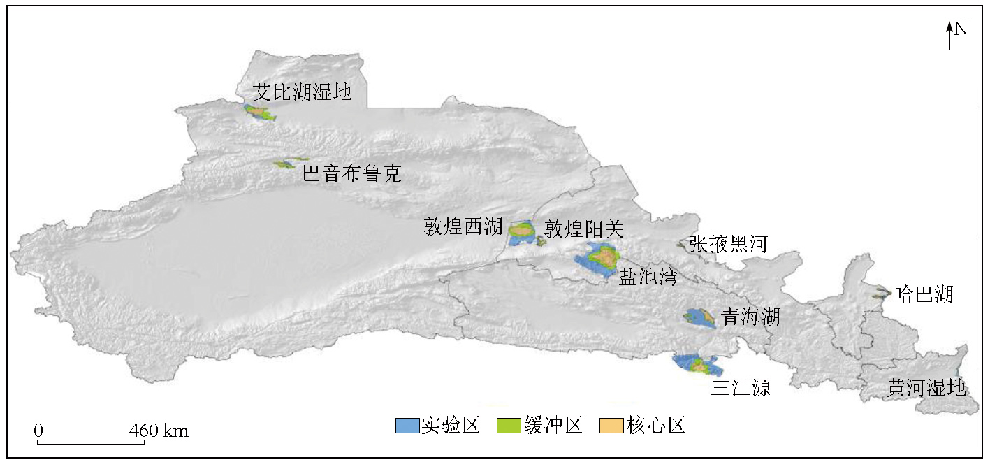
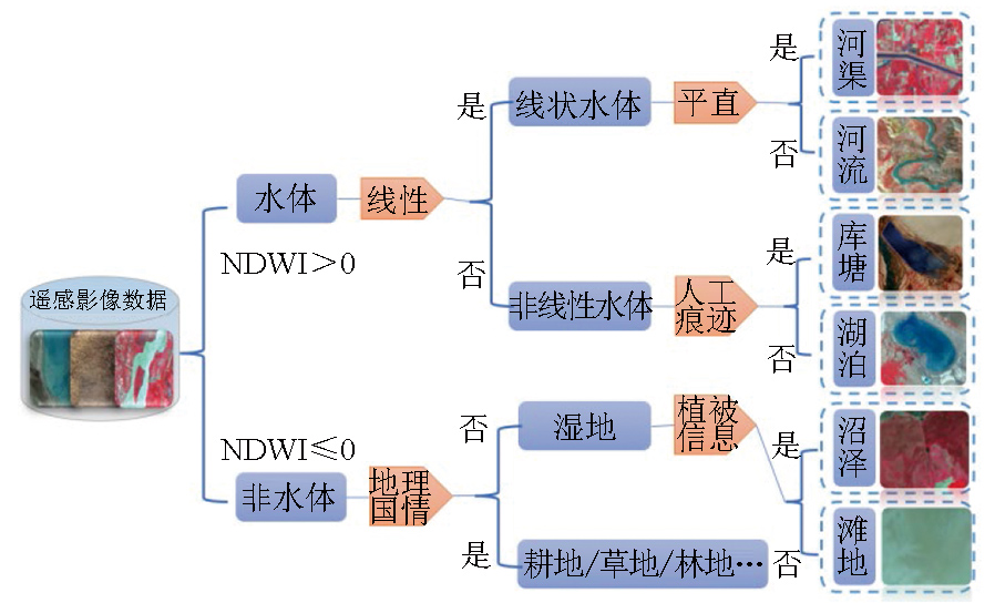
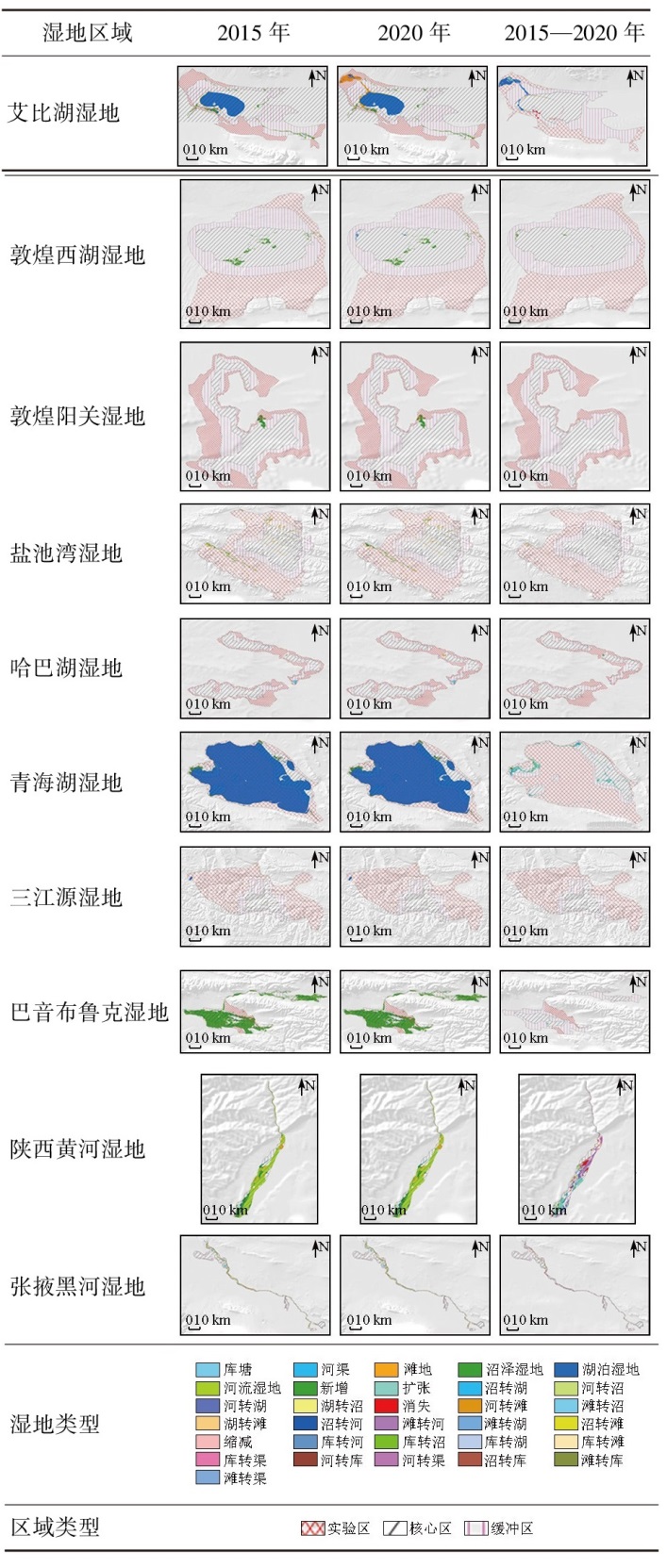
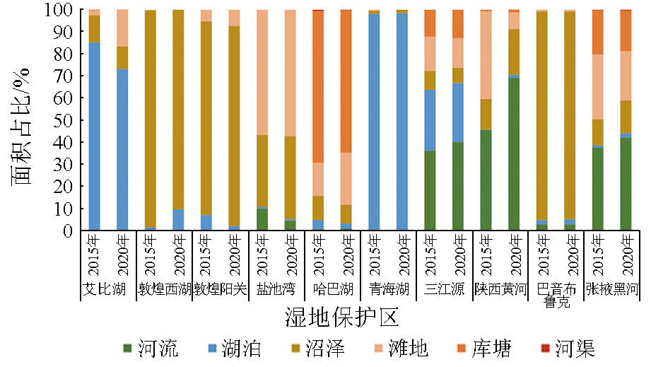
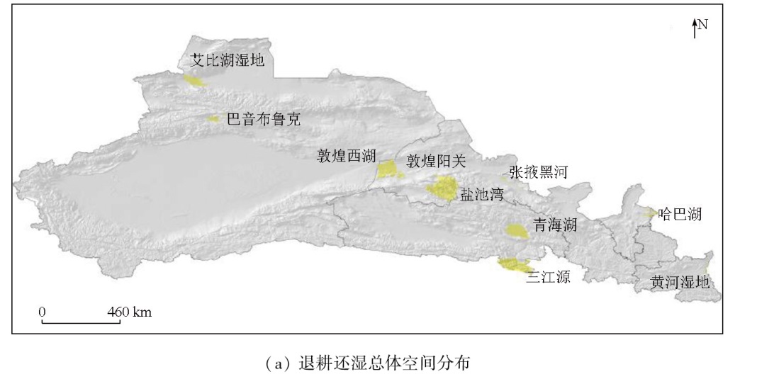
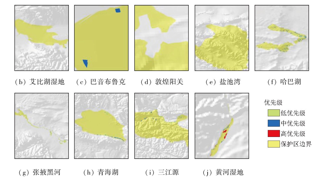
Abstract Wetlands, hailed as the "kidneys of the Earth", hold great significance for maintaining the stability of ecosystems. This study investigated 10 important wetland reserves along the Silk Road. Based on remote sensing data from the ZY3 satellite, it extracted the wetland types in 2015 and 2020 through interactions between object-oriented analysis and manual interpretation. As a result, a dataset of wetland distribution and its dynamic changes in the reserves was established. By combining topography, hydrological conditions, ecological importance, and wetland type transition, this study proposed a method for assessing the spatial potential of returning farmlands to wetlands. The results of wetland information extraction show that from 2015 to 2020, the wetland area in the 10 reserves exhibited a net increase of 238.04 km2 thanks to both natural and anthropogenic factors. Such an increase was dominated by lacustrine wetlands, with the wetland rate rising by 0.58% generally. This demonstrates that the establishment of ecological reserves posed a positive impact on regional wetland protection. However, in local regions, wetlands still showed a trend of degradation, covering an area of 77.00 km2. The potential analysis results of returning farmlands to wetlands indicate that a total of 325.13 km2 of farmlands should be returned to wetlands, consisting of 10.63 km2 requiring high-priority restoration, 167.02 km2 subjected to medium-priority restoration, and 147.48 km2 requiring low-priority restoration. The proposed region-specific scheme for ecological restoration in wetlands can provide decision-making support for wetland protection and management along the Silk Road.
|
| Keywords
Silk Road
wetland conservation
remote sensing image classification
ecological restoration
|
|
|
|
Issue Date: 03 September 2025
|
|
|
| [1] |
Mitsch W J, Gosselink J G. Wetlands[M]. 2nd ed. New York: Van Nostrand Reinhold, 1993.
|
| [2] |
Wang Z M, Wu J G, Madden M, et al. China’s wetlands:Conservation plans and policy impacts[J]. Ambio, 2012, 41(7):782-786.
|
| [3] |
自然资源部. TD/T 1055—2019第三次全国国土调查技术规程[S]. 北京: 自然资源部, 2017.
|
| [3] |
Minstry of Natural Resources of the People’s Republic of China. TD/T 1055—2019 Technical regulation of the third nationwide land survey[S]. Beijing: Minstry of Natural Resources of the People’s Republic of China, 2017.
|
| [4] |
Luo J H, Ma R H, Duan H T, et al. A new method for modifying thresholds in the classification of tree models for mapping aquatic vegetation in Taihu Lake with satellite images[J]. Remote Sensing, 2014, 6(8):7442-7462.
|
| [5] |
于欢, 张树清, 赵军, 等. 基于ALOS遥感影像的湿地地表覆被信息提取研究[J]. 地球科学与环境学报, 2010, 32(3):324-330.
|
| [5] |
Yu H, Zhang S Q, Zhao J, et al. Study on wetland cover information extraction based on ALOS remote sensing image[J]. Journal of Earth Sciences and Environment, 2010, 32(3):324-330.
|
| [6] |
明義森, 刘启航, 柏荷, 等. 利用光学和SAR遥感数据的若尔盖湿地植被分类与变化监测[J]. 遥感学报, 2023, 27(6):1414-1425.
|
| [6] |
Ming Y S, Liu Q H, Bai H, et al. Classification and change detection of vegetation in the Ruoergai Wetland using optical and SAR remote sensing data[J]. National Remote Sensing Bulletin, 2023, 27(6):1414-1425.
|
| [7] |
何兴元, 贾明明, 王宗明, 等. 基于遥感的三江平原湿地保护工程成效初步评估[J]. 中国科学院院刊, 2017, 32(1):3-10.
|
| [7] |
He X Y, Jia M M, Wang Z M, et al. Remote sensing based evaluation of effectiveness of wetland protection project in Sanjiang Plain,China[J]. Bulletin of Chinese Academy of Sciences, 2017, 32(1):3-10.
|
| [8] |
黄翀, 刘高焕, 傅新, 等. 黄河三角洲刁口河流路湿地恢复遥感监测与评价[J]. 地理科学进展, 2012, 31(5):570-576.
|
| [8] |
Huang C, Liu G H, Fu X, et al. Monitoring and evaluation of wetland restoration in the abandoned Diaokou Estuary of Yellow River Delta based on HJ-1 remote sensing data[J]. Progress in Geography, 2012, 31(5):570-576.
doi: 10.11820/dlkxjz.2012.05.004
|
| [9] |
Xiang H X, Wang Z M, Mao D H, et al. What did China’s National Wetland Conservation Program achieve? Observations of changes in land cover and ecosystem services in the Sanjiang Plain[J]. Journal of Environmental Management, 2020, 267:110623.
|
| [10] |
Ozesmi S L, Bauer M E. Satellite remote sensing of wetlands[J]. Wetlands Ecology and Management, 2002, 10(5):381-402.
|
| [11] |
王娅, 郭继发, 林雨. 基于面向对象方法的天津市滨海新区湿地信息提取[J]. 山东理工大学学报(自然科学版), 2023, 37(6):25-31.
|
| [11] |
Wang Y, Guo J F, Lin Y. Wetland information extraction from Tianjin Binhai New Area based on object-oriented method[J]. Journal of Shandong University of Technology (Natural Science Edition), 2023, 37(6):25-31.
|
| [12] |
Liu C, Tao R, Li W, et al. Joint classification of hyperspectral and multispectral images for mapping coastal wetlands[J]. IEEE Journal of Selected Topics in Applied Earth Observations and Remote Sensing, 2020, 14:982-996.
|
| [13] |
Gosselin G, Touzi R, Cavayas F. Polarimetric Radarsat-2 wetland classification using the Touzi decomposition:Case of the Lac Saint-Pierre Ramsar wetland[J]. Canadian Journal of Remote Sensing, 2014, 39(6):491-506.
|
| [14] |
王文柳, 韩震, 李静, 等. SVM核函数对南汇潮滩湿地高分二号卫星数据分类精度的影响分析[J]. 海洋湖沼通报, 2020, 42(2):78-89.
|
| [14] |
Wang W L, Han Z, Li J, et al. Influence of different SVM kernel functions on the classification accuracy of GF-2 image in Nanhui tidal flat[J]. Transactions of Oceanology and Limnology, 2020, 42(2):78-89.
|
| [15] |
Qian Y G, Zhou W Q, Yan J L, et al. Comparing machine learning classifiers for object-based land cover classification using very high resolution imagery[J]. Remote Sensing, 2015, 7(1):153-168.
|
| [16] |
Franklin S, Ahmed O. Object-based wetland characterization using Radarsat-2 Quad-polarimetric SAR data,Landsat8 OLI imagery,and airborne LiDAR-derived geomorphometric variables[J]. Photogrammetric Engineering and Remote Sensing, 2017, 83(1):27-36.
|
| [17] |
Reif M, Frohn R C, Lane C R, et al. Mapping isolated wetlands in a Karst landscape:GIS and remote sensing methods[J]. GIScience and Remote Sensing, 2009, 46(2):187-211.
|
| [18] |
Dronova I. Object-based image analysis in wetland research:A review[J]. Remote Sensing, 2015, 7(5):6380-6413.
|
| [19] |
Powers R P, Hay G J, Chen G. How wetland type and area differ through scale:A GEOBIA case study in Alberta’s Boreal Plains[J]. Remote Sensing of Environment, 2012, 117:135-145.
|
| [20] |
Cordeiro C, Rossetti D. Mapping vegetation in a late Quaternary landform of the Amazonian wetlands using object-based image analysis and decision tree classification[J]. International Journal of Remote Sensing, 2015, 36(13):3397-3422.
|
| [21] |
白穆, 王馨爽, 孟小亮, 等. 陕西黄河湿地省级自然保护区保护成效遥感监测与分析[J]. 测绘地理信息, 2023, 48(5):85-91.
|
| [21] |
Bai M, Wang X S, Meng X L, et al. Remote sensing monitoring and analysis of conservation effectiveness in Shaanxi Yellow River wetland provincial nature reserve[J]. Journal of Geomatics, 2023, 48(5):85-91.
|
| [22] |
陈雪初, 高如峰, 黄晓琛, 等. 欧美国家盐沼湿地生态恢复的基本观点、技术手段与工程实践进展[J]. 海洋环境科学, 2016, 35(3):467-472.
|
| [22] |
Chen X C, Gao R F, Huang X C, et al. Basic views and technological methods of salt marsh restoration and its progresses in implementation[J]. Marine Environmental Science, 2016, 35(3):467-472.
|
| [23] |
于寒, 周茜冉, 邹元春, 等. 湿地生态恢复技术研究现状与展望[J]. 安徽农业科学, 2023, 51(22):20-25.
|
| [23] |
Yu H, Zhou X R, Zou Y C, et al. Research status and prospect of wetland ecological restoration techniques[J]. Journal of Anhui Agricultural Sciences, 2023, 51(22):20-25.
|
| [24] |
张月, 张飞, 王娟, 等. 近40年艾比湖湿地自然保护区生态干扰度时空动态及景观格局变化[J]. 生态学报, 2017, 37(21):7082-7097.
|
| [24] |
Zhang Y, Zhang F, Wang J, et al. Analysis of the temporal and spatial dynamics of landscape patterns and hemeroby index of the Ebinur Lake Wetland Nature Reserve,Xinjiang,over the last 40 years[J]. Acta Ecologica Sinica, 2017, 37(21):7082-7097.
|
| [25] |
杨俊仓, 施锦, 陈伟涛. 敦煌西湖湿地演化趋势及保护对策[J]. 兰州大学学报(自然科学版), 2014, 50(5):716-721.
|
| [25] |
Yang J C, Shi J, Chen W T. Evolution trend of and protection measures for Dunhuang west lake wetland[J]. Journal of Lanzhou University (Natural Sciences), 2014, 50(5):716-721.
|
| [26] |
孔东升, 张灏. 张掖黑河湿地自然保护区生态服务功能价值评估[J]. 生态学报, 2015, 35(4):972-983.
|
| [26] |
Kong D S, Zhang H. Economic value of wetland ecosystem services in the Heihe National Nature Reserve of Zhangye[J]. Acta Ecologica Sinica, 2015, 35(4):972-983.
|
| [27] |
符超, 金韬. 共同努力, 谱写全球湿地保护新篇章——《湿地公约》第十四届缔约方大会综述[J]. 绿色中国, 2022,(21):10-17.
|
| [27] |
Fu C, Jin T. Work together to write a new chapter in Global Wetlands Conservation[J]. Green China, 2022,(21):10-17.
|
| [28] |
刘平, 关蕾, 吕偲, 等. 中国第二次湿地资源调查的技术特点和成果应用前景[J]. 湿地科学, 2011, 9(3):284-289.
|
| [28] |
Liu P, Guan L, Lu C, et al. Technical characteristics and application prospects of achievements of the Second National Wetland Investigation[J]. Wetland Science, 2011, 9(3):284-289.
|
| [29] |
Mao D H, Wang Z M, Du B J, et al. National wetland mapping in China:A new product resulting from object-based and hierarchical classification of Landsat8 OLI images[J]. ISPRS Journal of Photogrammetry and Remote Sensing, 2020, 164:11-25.
|
| [30] |
Huang N, Wang Z M, Liu D W, et al. Selecting sites for converting farmlands to wetlands in the Sanjiang Plain,Northeast China,based on remote sensing and GIS[J]. Environmental Management, 2010, 46(5):790-800.
doi: 10.1007/s00267-010-9547-6
pmid: 20821010
|
| [31] |
Luo L, Mao D H, Wang Z M, et al. Remote sensing and GIS support to identify potential areas for wetland restoration from cropland:A case study in the West Songnen Plain,Northeast China[J]. Sustainability, 2018, 10(7):2375.
|
|
Viewed |
|
|
|
Full text
|
|
|
|
|
Abstract
|
|
|
|
|
Cited |
|
|
|
|
| |
Shared |
|
|
|
|
| |
Discussed |
|
|
|
|
 2025,
Vol. 37
2025,
Vol. 37