|
|
 |
|

|
|
|
Analyzing impact of the Beijing-Guangzhou high-speed railway on cities along the Hebei section based on remote sensing monitoring |
SU Boxiong1,2( ), WU Mingquan1,2(), NIU Zheng1,2, CHEN Fang2,3, HUANG Wenjiang1,2 ), WU Mingquan1,2(), NIU Zheng1,2, CHEN Fang2,3, HUANG Wenjiang1,2 |
1. Aerospace Information Research Institute, Key Laboratory of Remote Sensing and Digital Earth, Chinese Academy of Sciences, Beijing 100094, China
2. University of Chinese Academy of Sciences, Beijing 100049, China
3. Key Laboratory of Digital Earth Science, Chinese Academy of Sciences, Beijing 100094, China |
|
|
|
|
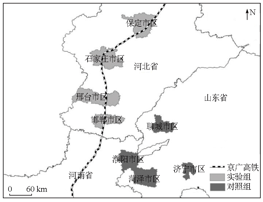
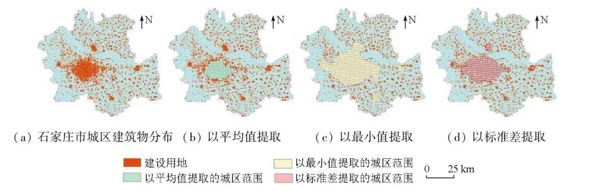
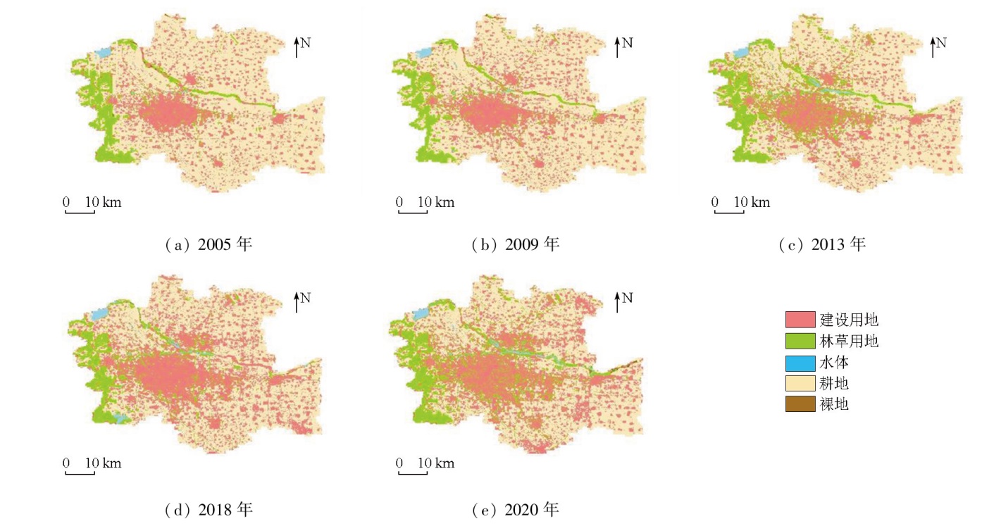
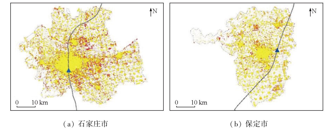
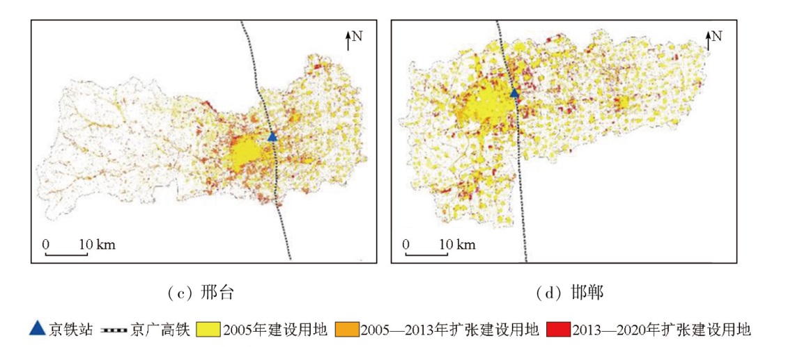
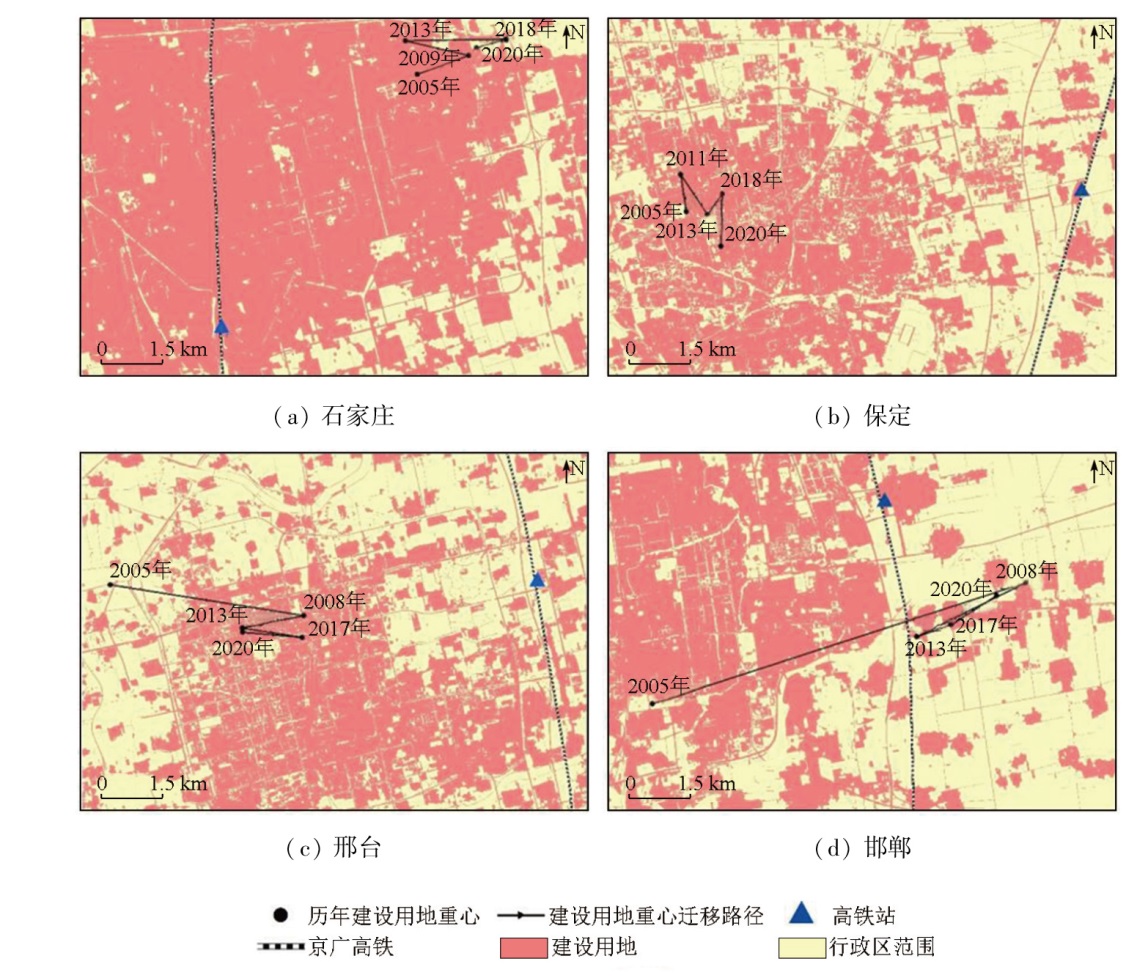
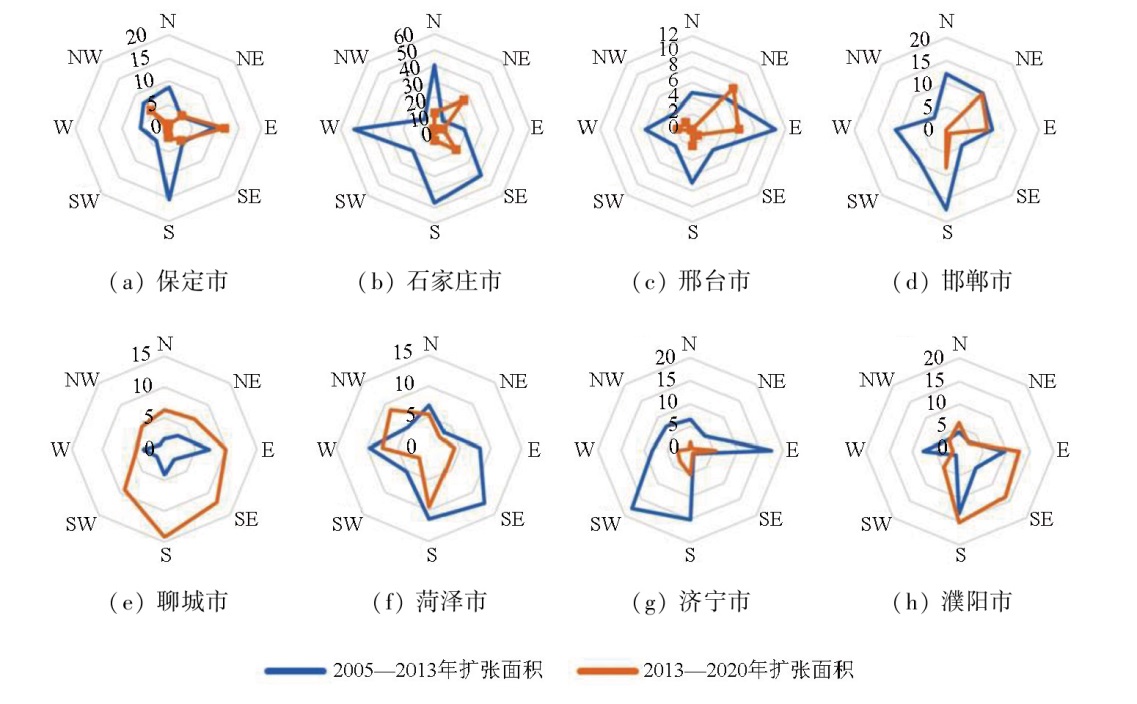
Abstract At present, the impacts of high-speed railways (HSRs) on cities along rail lines remain unclear. Previous analyses of these impacts based on remote sensing data focused primarily on qualitative assessment. Given this, this study investigated the Hebei section of the Beijing-Guangzhou HSR and introduced a remote sensing monitoring-based method that integrated qualitative and quantitative analyses for assessing the impacts of HSR on urban development. First, this study established a parameter index system used to characterize urban development changes. Then, multi-source and multi-scale remote sensing data were employed to monitor the spatiotemporal variations in these indices before and after the operation of the Beijing-Guangzhou HSR within this study area. Finally, four cities that were adjacent to the study area but lacked available HSRs were selected as a control group. Using the difference-in-differences (DID) model, this study quantified the impacts of HSRs on four cities along the Hebei section. The results indicate that the four cities along the Hebei section of the Beijing-Guangzhou HSR saw a rapid expansion in the construction land between 2005 and 2020, with an average annual expansion rate of 2.00%. The HSR construction exerted a significant impact on the direction of urban expansion, with the impact related to the spatial relationship between both. Compared to the four cities in the control group, the operation of the Beijing-Guangzhou HSR has slowed down the expansion rates of urban areas in the four cities along the line.
|
| Keywords
urban expansion
land use
night light
high-speed railway (HSR)
|
|
|
|
Issue Date: 03 September 2025
|
|
|
| [1] |
中国城市规划设计研究院. GB/T 50280—98 城市规划基本术语标准[S]. 北京: 国家市场监督管理总局,1998.
|
| [1] |
China Academy of Urban Planning and Design. GB/T 50280—98 standard for basic terminology of urban planning[S]. Beijing: State Administration for Market Regulation,1998.
|
| [2] |
Vendemmia B. Big infrastructures effects on local developments:The case of Naples Metropolitan Area[J]. TeMA -Journal of Land Use,Mobility and Environment, 2011, 4(3):87-99.
|
| [3] |
Ewing R, Handy S. Measuring the unmeasurable:Urban design qualities related to walkability[J]. Journal of Urban Design, 2009, 14(1):65-84.
|
| [4] |
覃成林, 杨晴晴. 高速铁路发展与城市生产性服务业集聚[J]. 经济经纬, 2016, 33(3):1-6.
|
| [4] |
Qin C L, Yang Q Q. Development of high-speed railway and producer services agglomeration[J]. Economic Survey, 2016, 33(3):1-6.
|
| [5] |
李廷智, 杨晓梦, 赵星烁, 等. 高速铁路对城市和区域空间发展影响研究综述[J]. 城市发展研究, 2013, 20(2):71-79.
|
| [5] |
Li T Z, Yang X M, Zhao X S, et al. High-speed rail’s influence on urban and regional spatial development:A review[J]. Urban Development Studies, 2013, 20(2):71-79.
|
| [6] |
唐可月. 高速铁路对沿线站点城市经济发展的影响——以哈大高铁和郑西高铁为例[J]. 北京交通大学学报(社会科学版), 2020, 19(4):45-61.
|
| [6] |
Tang K Y. The influence of high-speed railway on the economic development of station cities along the line:A case study of Harbin-Dalian high speed railway and Zhengzhou-Xi’an high speed railway[J]. Journal of Beijing Jiaotong University (Social Sciences Edition), 2020, 19(4):45-61.
|
| [7] |
于策, 李远富, 林芳, 等. 基于GIS的津保铁路对沿线城市可达性影响分析[J]. 铁道运输与经济, 2017, 39(5):18-22.
|
| [7] |
Yu C, Li Y F, Lin F, et al. Analysis on influence of Tianjin-Bao-ding railway on accessibility of adjacent cities based on GIS[J]. Railway Transport and Economy, 2017, 39(5):18-22.
|
| [8] |
张喆, 王晓梦, 姜雨皓, 等. 中老泰铁路建设对云南省及沿线国家空间联系格局的影响——基于城市流网络的分析[J]. 世界地理研究, 2019, 28(3):43-53.
|
| [8] |
Zhang Z, Wang X M, Jiang Y H, et al. The influence of China-Laos-Thailand railway construction on spatial relation between cities along the route:Based on city flow network analysis[J]. World Regional Studies, 2019, 28(3):43-53.
doi: 10.3969/j.issn.1004-9479.2019.03.2017245
|
| [9] |
Diao M. Does growth follow the rail? The potential impact of high-speed rail on the economic geography of China[J]. Transportation Research Part A:Policy and Practice, 2018, 113:279-290.
|
| [10] |
Huang Y, Zong H. Has high-speed railway promoted spatial equity at different levels? A case study of inland mountainous area of China[J]. Cities, 2021, 110:103076.
|
| [11] |
Shao Z G, Zhang L, Han C T, et al. Measurement and prediction of urban land traffic accessibility and economic contact based on GIS:A case study of land transportation in Shandong Province,China[J]. International Journal of Environmental Research and Public Health, 2022, 19(22):14867.
|
| [12] |
Ye C, Zheng Y H, Lin S L, et al. The impact of high-speed railway opening on regional economic growth:The case of the Wuhan-Guangzhou high-speed railway line[J]. Sustainability, 2022, 14(18):11390.
|
| [13] |
Puga D. Agglomeration and cross-border infrastructure[J]. EIB Papers, 2008, 13(2):102-124.
|
| [14] |
Gutiérrez J, González R, Gómez G. The European high-speed train network:Predicted effects on accessibility patterns[J]. Journal of Transport Geography, 1996, 4(4):227-238.
|
| [15] |
戴学珍, 徐敏, 李杰. 京沪高速铁路对沿线城市效率和空间公平的影响[J]. 经济地理, 2016, 36(3):72-77,108.
|
| [15] |
Dai X Z, Xu M, Li J. The efficiency and spatial equity impacts of Beijing-Shanghai high-speed rail on neighboring cities[J]. Economic Geography, 2016, 36(3):72-77,108.
|
| [16] |
蒋华雄, 蔡宏钰, 孟晓晨. 高速铁路对中国城市产业结构的影响研究[J]. 人文地理, 2017, 32(5):132-138.
|
| [16] |
Jiang H X, Cai H Y, Meng X C. The structural impact of high speed rail upon urban industries in China[J]. Human Geography, 2017, 32(5):132-138.
|
| [17] |
李响, 刘心怡, 李卫东, 等. 京沪高铁开通对房地产就业的影响——基于DID模型[J]. 综合运输, 2022, 44(3):24-28,54.
|
| [17] |
Li X, Liu X Y, Li W D, et al. Influence of Beijing-Shanghai high-speed railway opening on real estate employment:Based on DID model[J]. China Transportation Review, 2022, 44(3):24-28,54.
|
| [18] |
程婉静, 莫东序, 梁心悦, 等. 中国神黄铁路运煤专线开通对地区产业结构的影响——基于DID模型的实证研究[J]. 煤炭经济研究, 2020, 40(1):4-10.
|
| [18] |
Cheng W J, Mo D X, Liang X Y, et al. Impact of China Shenhuang railway dedicated coal line on regional industrial structure:Empirical research based on DID model[J]. Coal Economic Research, 2020, 40(1):4-10.
|
| [19] |
黄振宇, 吴立春. 京沪高铁对沿线城市经济的影响——基于空间经济学理论的实证分析[J]. 宏观经济研究, 2020(2):165-175.
|
| [19] |
Huang Z Y, Wu L C. Impact of Beijing-Shanghai high-speed railway on the economy of cities along the route:An empirical analysis based on the theory of space economics[J]. Macroeconomics, 2020(2):165-175.
|
| [20] |
吴嘉贤, 刘修岩. 高铁开通与中国农村减贫——来自遥感数据的证据[J]. 世界经济文汇, 2022(1):1-17.
|
| [20] |
Wu J X, Liu X Y. High-speed railways and rural poverty:Evidence from remote sensing data[J]. World Economic Papers, 2022(1):1-17.
|
| [21] |
Okamoto C, Sato Y. Impacts of high-speed rail construction on urban agglomerations:Evidence from Kyushu in Japan[J]. Journal of Asian Economics Journal, 2021, 76:101364.
|
| [22] |
张永庆, 刘聪. 高铁建设对江苏沿线区域发展影响研究——基于双重差分模型的估计[J]. 物流科技, 2021, 44(1):85-88.
|
| [22] |
Zhang Y Q, Liu C. Study on the influence of high-speed railway construction on the regional development along the line of Jiangsu Province:Estimation based on double difference model[J]. Logistics Sci-Tech, 2021, 44(1):85-88.
|
| [23] |
Jin M J, Lin K C, Shi W M, et al. Impacts of high-speed railways on economic growth and disparity in China[J]. Transportation Research Part A:Policy and Practice, 2020, 138:158-171.
|
| [24] |
刘长龙, 常军, 刘娜, 等. 高速铁路的建设对沿线区域土地利用变化影响研究——以京沪高铁山东段为例[J]. 西安理工大学学报, 2020, 36(3):367-375,423.
|
| [24] |
Liu C L, Chang J, Liu N, et al. Study of the effect of high-speed railway construction on the changes of surrounding area land use:Based the high speed railway of Beijing to Shanghai in Shandong Province[J]. Journal of Xi’an University of Technology, 2020, 36(3):367-375,423.
|
| [25] |
徐盼, 张晓祥, 晏王波, 等. 城市交通干线对盐城城市发展影响的空间分析[J]. 地球信息科学学报, 2013, 15(1):29-37.
|
| [25] |
Xu P, Zhang X X, Yan W B, et al. Urban transportation infrastructure and its effects on regional development in Yancheng:A spatial analysis perspective[J]. Journal of Geo-Information Science, 2013, 15(1):29-37.
|
| [26] |
Yang J, Huang X. The 30 m annual land cover dataset and its dynamics in China from 1990 to 2019[J]. Earth System Science Data, 2021, 13(8):3907-3925.
doi: 10.5194/essd-13-3907-2021
|
| [27] |
仲晓雅, 闫庆武, 李桂娥. 中国长时间序列夜间灯光数据集的研发(2000—2020)[J]. 全球变化数据学报(中英文), 2022, 6(3):416-424,593-601.
|
| [27] |
Zhong X Y, Yan Q W, Li G E. Development of time series of nighttime light dataset of China(2000—2020)[J]. Journal of Global Change Data and Discovery, 2022, 6(3):416-424,593-601.
|
| [28] |
Yu C H, Zhou Q, Li J L, et al. Foundation model drives weakly incremental learning for semantic segmentation[C]// 2023 IEEE/CVF Conference on Computer Vision and Pattern Recognition (CVPR).Vancouver,BC,Canada:IEEE, 2023: 23685-23694.
|
| [29] |
邓刘洋, 沈占锋, 柯映明. 城市建成区遥感影像边界提取与扩张分析[J]. 地球信息科学学报, 2018, 20(7):996-1003.
doi: 10.12082/dqxxkx.2018.170571
|
| [29] |
Deng L Y, Shen Z F, Ke Y M. Built-up area extraction and urban expansion analysis based on remote sensing images[J]. Journal of Geo-Information Science, 2018, 20(7):996-1003.
|
| [30] |
陈美招, 张炜康, 郑荣宝. 高铁开通促进了沿线城镇经济活动吗——来自双源夜间灯光证据[J]. 中国地质大学学报(社会科学版), 2021, 21(6):119-133.
|
| [30] |
Chen M Z, Zhang W K, Zheng R B. Does high speed railway promote the economic activities of cities and towns along the line:Evidence from dual source night lighting[J]. Journal of China University of Geosciences (Social Sciences Edition), 2021, 21(6):119-133.
|
|
Viewed |
|
|
|
Full text
|
|
|
|
|
Abstract
|
|
|
|
|
Cited |
|
|
|
|
| |
Shared |
|
|
|
|
| |
Discussed |
|
|
|
|
 2025,
Vol. 37
2025,
Vol. 37