|
|
 |
|

|
|
|
Ecological protection assessment of cultivated land in the black soil region based on remote sensing data |
SHI Xiaochen1,2( ), LUO Chenying2, ZHANG Chao2(), WANG Wei3, CHEN Chang2, BAI Xuechuan2, LI Shaoshuai4 ), LUO Chenying2, ZHANG Chao2(), WANG Wei3, CHEN Chang2, BAI Xuechuan2, LI Shaoshuai4 |
1. Shouguang Municipal Bureau of Natural Resources and Planning, Weifang 262700, China
2. College of Land Science and Technology, China Agricultural University, Beijing 100193, China
3. Da’an Municipal Bureau of Natural Resources, Baicheng 131399, China
4. Land Consolidation and Rehabilitation Center, Ministry of Natural Resources, Beijng 100035, China |
|
|
|
|
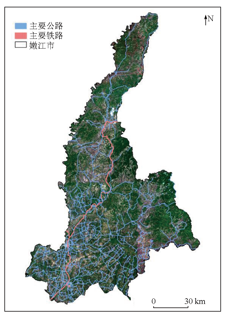
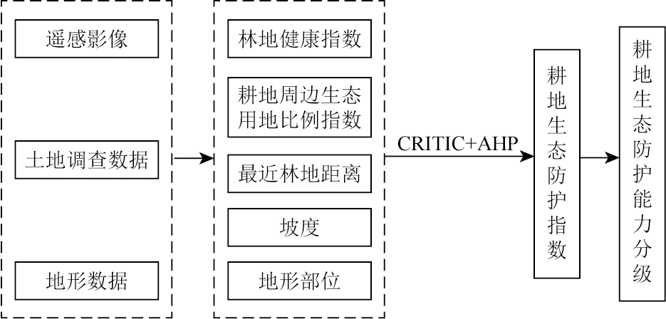
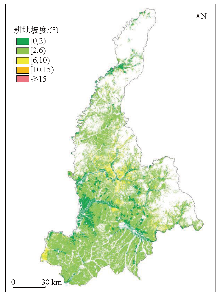
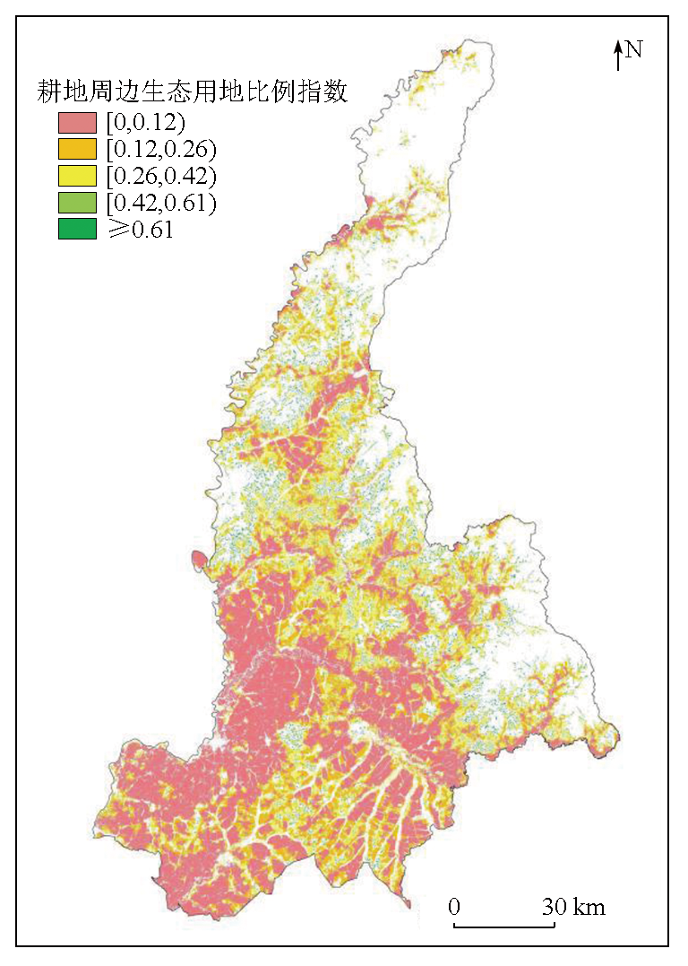
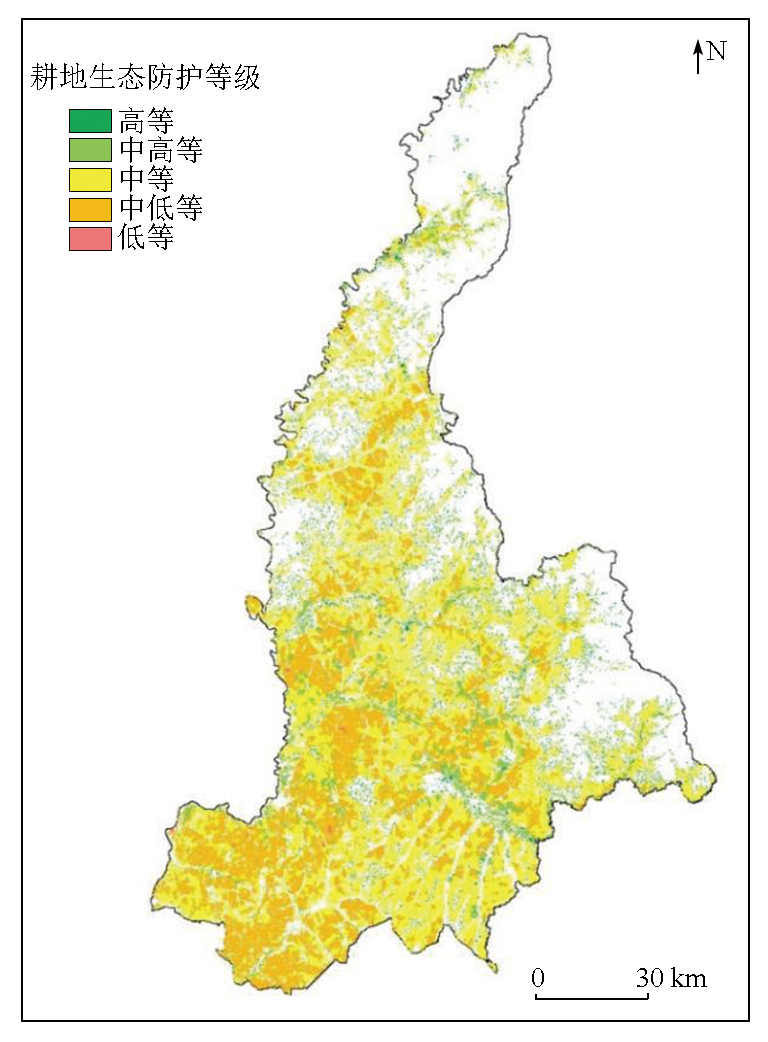
Abstract The black soil region in Northeast China is a major grain-producing area in China. To ensure the sustainable development of agriculture in the black soil region, the data from the third national land resource survey, remote sensing data, and the digital elevation model (DEM) can be integrated to explore the ecological protection assessment methods for cultivated land. This study investigated Nenjiang City, Heilongjiang Province, from the location conditions of cultivated land and surrounding ecological land use. It constructed five indicators, including the forest health index, the proportion of ecological land surrounding cultivated land, the distance to the nearest forest, the slope, and the topographic position. Notably, an improved forest health index was designed based on the remote sensing ecological index to comprehensively assess the ecological protection of cultivated land in Nenjiang City. The results indicate that the cultivated land in Nenjiang City was dominated by medium-low and medium ecological protection grades, covering 34.21% and 45.28% of the cultivated land area, respectively. In contrast, the high-grade cultivated land accounted for merely 2.11%, indicating considerable potential for improving the ecological protection grade of cultivated land. Among individual indicators, the proportion of ecological land around cultivated land and the forest health index exhibited low values, serving as the primary factors leading to an overall slightly low geological protection grade in the study area.
|
| Keywords
black soil region
cultivated land
ecological protection
assessment
remote sensing
Nenjiang City
|
|
|
|
Issue Date: 31 December 2025
|
|
|
| [1] |
葛良胜, 夏锐. 高标准农田建设:基于地表基质调查的解决方案[J]. 中国国土资源经济, 2023, 36(5):4-13.
|
| [1] |
Ge L S, Xia R. High-standard farmland construction:Ground substrate survey-based solutions[J]. Natural Resource Economics of China, 2023, 36(5):4-13.
|
| [2] |
祖健, 郝晋珉, 陈丽, 等. 耕地数量、质量、生态三位一体保护内涵及路径探析[J]. 中国农业大学学报, 2018, 23(7):84-95.
|
| [2] |
Zu J, Hao J M, Chen L, et al. Analysis on trinity connotation and approach to protect quantity,quality and ecology of cultivated land[J]. Journal of China Agricultural University, 2018, 23(7):84-95.
|
| [3] |
张超, 乔敏, 郧文聚, 等. 耕地数量、质量、生态三位一体综合监管体系研究[J]. 农业机械学报, 2017, 48(1):1-6.
|
| [3] |
Zhang C, Qiao M, Yun W J, et al. Trinity comprehensive regulatory system about quantity,quality and ecology of cultivated land[J]. Transactions of the Chinese Society for Agricultural Machinery, 2017, 48(1):1-6.
|
| [4] |
徐英德, 裴久渤, 李双异, 等. 东北黑土地不同类型区主要特征及保护利用对策[J]. 土壤通报, 2023, 54(2):495-504.
|
| [4] |
Xu Y D, Pei J B, Li S Y, et al. Main characteristics and utilization countermeasures for black soils in different regions of Northeast China[J]. Chinese Journal of Soil Science, 2023, 54(2):495-504.
|
| [5] |
Chidi C L, Zhao W, Thapa P, et al. Evaluation of traditional rain-fed agricultural terraces for soil erosion control through UAV observation in the middle mountain of Nepal[J]. Applied Geography, 2022,148:102793.
|
| [6] |
姜芸, 王军, 滕浩, 等. 基于TOPSIS模型的典型黑土区耕地质量评价及土壤侵蚀耦合协调分析[J]. 农业工程学报, 2023, 39(12):82-94.
|
| [6] |
Jiang Y, Wang J, Teng H, et al. Coupling coordination analysis of the quality evaluation of cultivated land and soil erosion in typical black soil areas using TOPSIS method[J]. Transactions of the Chinese Society of Agricultural Engineering, 2023, 39(12):82-94.
|
| [7] |
赵娅君, 郑粉莉, 安小兵, 等. 典型黑土区坡耕地融雪、风力、降雨复合侵蚀效应[J]. 应用生态学报, 2023, 34(9):2421-2428.
doi: 10.13287/j.1001-9332.202309.013
|
| [7] |
Zhao Y J, Zheng F L, An X B, et al. Compound erosion effect of snowmelt,wind,and rainfall on sloping farmlands of Chinese typical mollisol region[J]. Chinese Journal of Applied Ecology, 2023, 34(9):2421-2428.
|
| [8] |
陈家宙, 何阳波, 高钰淏, 等. 1970—2021年典型黑土区侵蚀沟损毁耕地速度与发育阶段[J]. 农业工程学报, 2023, 39(12):51-59.
|
| [8] |
Chen J Z, He Y B, Gao Y H, et al. Farmland damage speed and development stage of gully erosion in typical black soil region from 1970 to 2021[J]. Transactions of the Chinese Society of Agricultural Engineering, 2023, 39(12):51-59.
|
| [9] |
徐金忠. 典型黑土区切沟发育关键驱动因素及特征研究[D]. 哈尔滨: 东北林业大学, 2020.
|
| [9] |
Xu J Z. Gully initial factors and characteristics in typical mollisols area[D]. Harbin: Northeast Forestry University, 2020.
|
| [10] |
魏文杰, 袁利, 李文龙, 等. 县域尺度风力侵蚀栅格计算结果落地研究[J]. 水土保持研究, 2023, 30(4):42-46,52.
|
| [10] |
Wei W J, Yuan L, Li W L, et al. Study on the grid calculation results of wind erosion at county scale[J]. Research of Soil and Water Conservation, 2023, 30(4):42-46,52.
|
| [11] |
秦琪珊. 黑土坡面侵蚀动力因子对水蚀过程影响的试验研究[D]. 杨凌: 西北农林科技大学, 2023.
|
| [11] |
Qin Q S. Impacts of erosive force factors on hillslope water erosion process in typical mollisol region of Northeast China[D]. Yang-ling: Northwest A & F University, 2023.
|
| [12] |
杜兆国, 肖洋, 张瑞豪, 等. 东北黑土区坡耕地侵蚀沟浅层土壤酶特征及其影响因素[J]. 中国水土保持, 2023(8):38-43.
|
| [12] |
Du Z G, Xiao Y, Zhang R H, et al. Characteristics of soil enzymes and its influencing factors in surface soil of eroded gullies on sloping farmland in the black soil region of Northeast China[J]. Soil and Water Conservation in China, 2023(8):38-43.
|
| [13] |
张瑞豪, 肖洋, 徐金忠, 等. 坡耕地黑土侵蚀沟演变对土壤结构及抗蚀性的影响[J]. 水土保持研究, 2023, 30(5):69-75.
|
| [13] |
Zhang R H, Xiao Y, Xu J Z, et al. Effect of black soil erosion gully evolution on soil structural features and anti-erodibility in sloping farmland[J]. Research of Soil and Water Conservation, 2023, 30(5):69-75.
|
| [14] |
徐涵秋. 城市遥感生态指数的创建及其应用[J]. 生态学报, 2013, 33(24):7853-7862.
|
| [14] |
Xu H Q. A remote sensing urban ecological index and its application[J]. Acta Ecologica Sinica, 2013, 33(24):7853-7862.
|
| [15] |
刘玉佳, 彭建, 李刚勇, 等. 基于GEE的库鲁斯台草原生态环境评价[J]. 生态学杂志, 2023, 42(11):2776-2785.
|
| [15] |
Liu Y J, Peng J, Li G Y, et al. Eco-environmental assessment of Kurustai grassland based on Google Earth Engine[J]. Chinese Journal of Ecology, 2023, 42(11):2776-2785.
doi: 10.13292/j.1000-4890.202311.010
|
| [16] |
薛桦, 刘萍. 基于RSEI的黄河中游地区生态环境质量时空演化特征及驱动因素——以延安市为例[J]. 水土保持研究, 2024, 31(1):373-384.
|
| [16] |
Xue H, Liu P. Spatiotemporal variation of ecological environmental quality and its response to different driving factors in the section of Yellow River Basin in recent 31 years:Taking Yan’an City as an example[J]. Research of Soil and Water Conservation, 2024, 31(1):373-384.
|
| [17] |
刘尚钦, 张福浩, 赵习枝, 等. 干旱区绿洲遥感生态指数的改进[J]. 测绘科学, 2022, 47(6):143-151,203.
|
| [17] |
Liu S Q, Zhang F H, Zhao X Z, et al. Improvement of remote sensing ecological index in oasis in arid area[J]. Science of Surveying and Mapping, 2022, 47(6):143-151,203.
|
| [18] |
王正兴, 刘闯, 陈文波, 等. MODIS增强型植被指数EVI与NDVI初步比较[J]. 武汉大学学报(信息科学版), 2006, 31(5):407-410,427.
|
| [18] |
Wang Z X, Liu C, Chen W B, et al. Preliminary comparison of MODIS-NDVI and MODIS-EVI in eastern Asia[J]. Geomatics and Information Science of Wuhan University, 2006, 31(5):407-410,427.
|
| [19] |
Son N T, Chen C F, Chen C R, et al. A comparative analysis of multitemporal MODIS EVI and NDVI data for large-scale rice yield estimation[J]. Agricultural and Forest Meteorology, 2014,197:52-64.
|
| [20] |
陈学兄, 张小军, 常庆瑞. 陕西省地形起伏度最佳计算单元研究[J]. 水土保持通报, 2016, 36(3):265-270,370.
|
| [20] |
Chen X X, Zhang X J, Chang Q R. A study on optimal statistical unit for relief amplitude of land surface in Shaanxi Province[J]. Bulletin of Soil and Water Conservation, 2016, 36(3):265-270,370.
|
| [21] |
De Reu J, Bourgeois J, Bats M, et al. Application of the topographic position index to heterogeneous landscapes[J]. Geomorphology, 2013,186:39-49.
|
| [22] |
张军, 李晓东, 陈春艳, 等. 新疆地势起伏度的分析研究[J]. 兰州大学学报(自然科学版), 2008, 44(s1):10-13,19.
|
| [22] |
Zhang J, Li X D, Chen C Y, et al. Analysis of the relief amplitude in Xinjiang[J]. Journal of Lanzhou University (Natural Sciences), 2008, 44(s1):10-13,19.
|
| [23] |
张伟, 李爱农. 基于DEM的中国地形起伏度适宜计算尺度研究[J]. 地理与地理信息科学, 2012, 28(4):8-12.
|
| [23] |
Zhang W, Li A N. Study on the optimal scale for calculating the relief amplitude in China based on DEM[J]. Geography and Geo-Information Science, 2012, 28(4):8-12.
|
| [24] |
董莉莉, 于雷, 韩素梅. 我国农田防护林研究进展[J]. 西南林业大学学报, 2011, 31(4):89-93.
|
| [24] |
Dong L L, Yu L, Han S M. Research progress in farmland shelterbelt planting in China[J]. Journal of Southwest Forestry University, 2011, 31(4):89-93.
|
| [25] |
Vigiak O, Sterk G, Warren A, et al. Spatial modeling of wind speed around windbreaks[J]. Catena, 2003, 52(3-4):273-288.
doi: 10.1016/S0341-8162(03)00018-3
url: https://linkinghub.elsevier.com/retrieve/pii/S0341816203000183
|
| [26] |
杨曦光, 李雨轩, 于颖, 等. 应用GIS对农田防护林防风效能评价[J]. 东北林业大学学报, 2022, 50(3):77-80,92.
|
| [26] |
Yang X G, Li Y X, Yu Y, et al. Efficiency evaluation of wind protection of windbreaks by GIS[J]. Journal of Northeast Forestry University, 2022, 50(3):77-80,92.
|
| [27] |
汪立韬, 肖辉杰, 辛智鸣, 等. 乌兰布和沙漠绿洲区典型农田防护林带风速流场数值模拟[J]. 中国水土保持科学(中英文), 2023, 21(4):11-19.
|
| [27] |
Wang L T, Xiao H J, Xin Z M, et al. Numerical simulation of wind speed field in the typical farmland shelterbelts in the oases of the Ulan Buh Desert[J]. Science of Soil and Water Conservation, 2023, 21(4):11-19.
|
| [28] |
李春泽, 张超, 张皓源, 等. 基于XGBoost与地理加权回归的吉林省西部土壤盐渍化反演[J]. 中国农业大学学报, 2024, 29(2):1-10.
|
| [28] |
Li C Z, Zhang C, Zhang H Y, et al. Inversion of soil salinization in western Jilin Province based on XGBoost and geographically weighted regression[J]. Journal of China Agricultural University, 2024, 29(2):1-10.
|
| [29] |
赵晓丹, 杨雅萍, 荆文龙. 基于AHP的湖南省耕地适宜性综合评价[J]. 水土保持研究, 2015, 22(2):219-223,348.
|
| [29] |
Zhao X D, Yang Y P, Jing W L. Evaluation on comprehensive suitability of cultivated land in Hunan Province based on AHP[J]. Research of Soil and Water Conservation, 2015, 22(2):219-223,348.
|
| [30] |
Xue R, Wang C, Liu M L, et al. A new method for soil health assessment based on analytic hierarchy process and meta-analysis[J]. Science of The Total Environment, 2019,650:2771-2777.
|
| [31] |
张玉泽, 任建兰, 刘凯, 等. 山东省生态安全预警测度及时空格局[J]. 经济地理, 2015, 35(11):166-171,189.
|
| [31] |
Zhang Y Z, Ren J L, Liu K, et al. The ecological security early warning measures and space-time pattern of Shandong Province[J]. Economic Geography, 2015, 35(11):166-171,189.
|
| [32] |
何新莹, 聂艳, 王朴, 等. 基于改进灰靶模型的耕地质量评价方法与实证[J]. 土壤学报, 2023, 60(4):1007-1016.
|
| [32] |
He X Y, Nie Y, Wang P, et al. Cultivated land quality evaluation method and demonstration based on improved grey target model[J]. Acta Pedologica Sinica, 2023, 60(4):1007-1016.
|
| [33] |
李文博. 基于立地条件与地化特征的黑土区城郊耕地质量变化研究[D]. 长春: 吉林大学, 2018.
|
| [33] |
Li W B. A study on varied cultivated land quality using site conditions and soil geo-chemistry characteristics as indicators in a peri-urban area of the black soil region[D]. Changchun: Jilin University, 2018.
|
| [34] |
钱凤魁. 基于耕地质量及其立地条件评价体系的基本农田划定研究——以辽宁省凌源市为例[D]. 沈阳: 沈阳农业大学, 2011.
|
| [34] |
Qian F K. Study on the planning of basic farmland based on the evaluation system of farmland quality and site conditions:A case study of Lingyuan City in Liaoning Province[D]. Shenyang: Shenyang Agricultural University, 2011.
|
| [35] |
Esmaeili E, Shahbazi F, Sarmadian F, et al. Land capability evaluation using NRCS agricultural land evaluation and site assessment (LESA) system in a semi-arid region of Iran[J]. Environmental Earth Sciences, 2021, 80(4):163.
doi: 10.1007/s12665-021-09468-y
|
| [36] |
齐丽. 基于LESA体系的高标准基本农田立地条件评价:以沈阳市法库县为例[J]. 农技服务, 2020, 37(1):66-69.
|
| [36] |
Qi L. Evaluation of site conditions of high-standard basic farmland based on LESA system:A case study of Faku County,Shenyang City[J]. Agricultural Technology Service, 2020, 37(1):66-69.
|
|
Viewed |
|
|
|
Full text
|
|
|
|
|
Abstract
|
|
|
|
|
Cited |
|
|
|
|
| |
Shared |
|
|
|
|
| |
Discussed |
|
|
|
|
 2025,
Vol. 37
2025,
Vol. 37