|
|
|
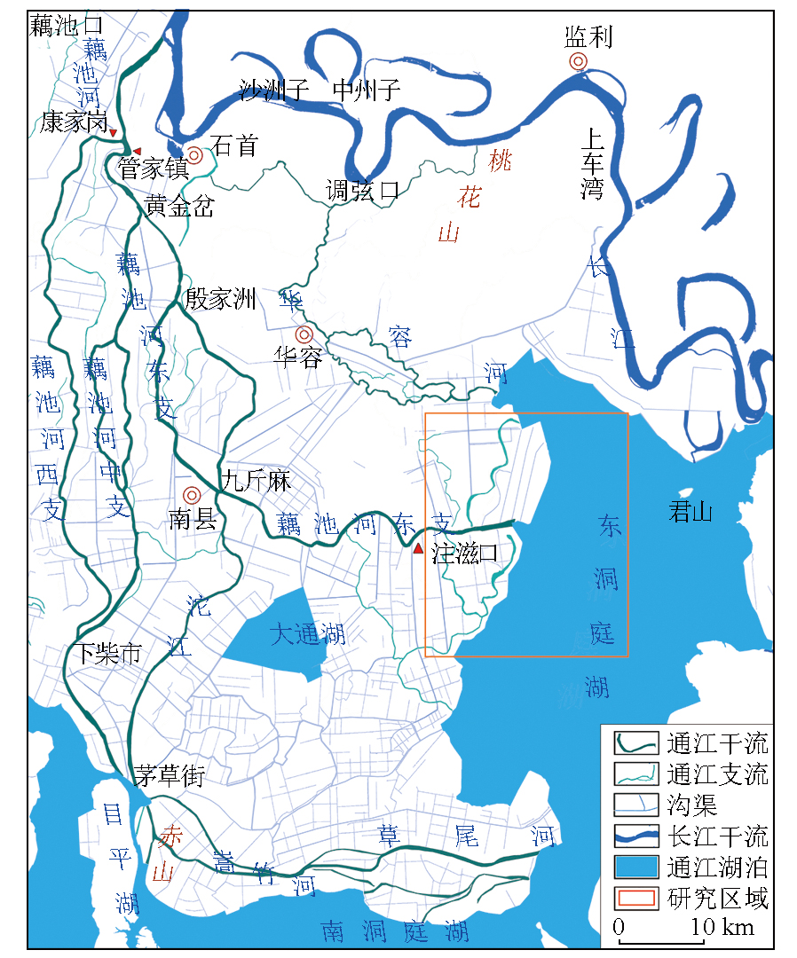
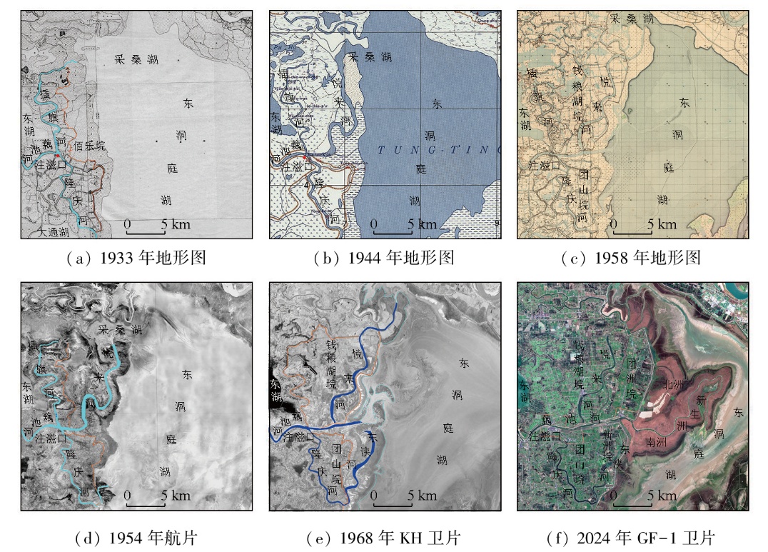
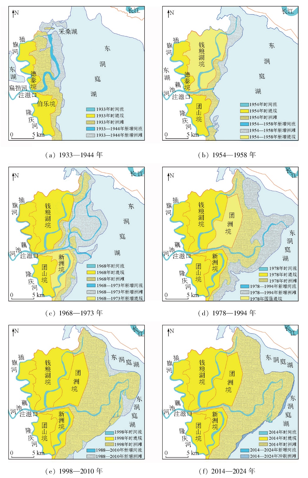
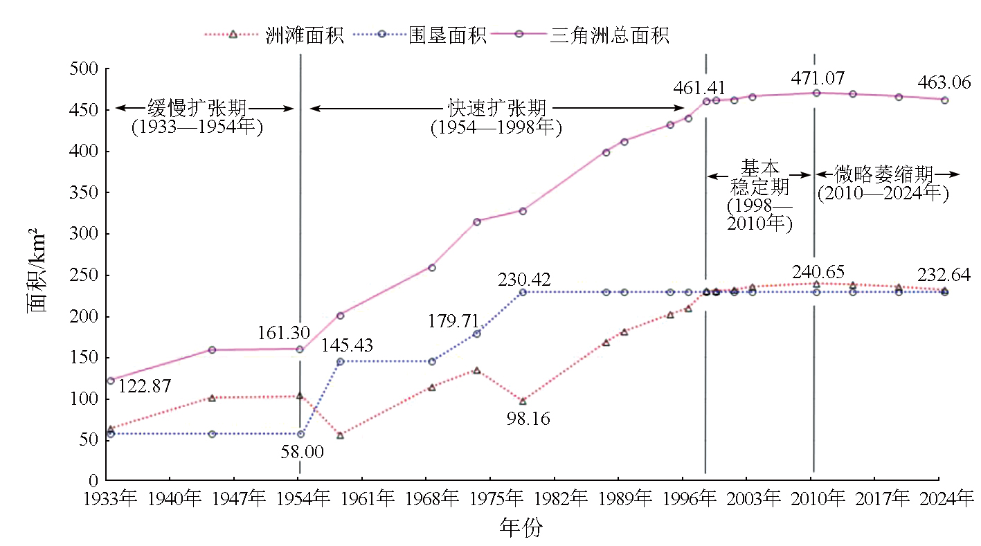
Abstract The Zhuzikou delta,located on the east branch of the Ouchi River,has been one of the fastest-growing and largest marshlands in the Dongting Lake area over the past century. Based on the historical maps and aerospace remote sensing data from 20 periods since 1933,this paper analyzed the spatiotemporal evolution of the delta through remote sensing interpretation and historical comparative analysis. The results showed that over the past 90 years,the Zhuzikou delta had been persistently advancing towards the lake area,with the deposited high-level bottomland being reclaimed into embankments. The old river channels had been abandoned and evolved into inner lakes of a blocked river type within the embankments,while the new river channels had been continuously extended towards the lake area along changing paths caused by multiple course changes. The channels of the lower reaches in the Zhuzikou delta have extended 38.99 km towards the lake area at an average annual rate of 428.46 m/a. The sedimentation area in the delta has expanded to 340.19 km2 at an average annual rate of 3.74 km2/a. Reclamation of the delta has been carried out in parallel with sedimentation,with a cumulatively reclaimed area of 230.42 km2,accounting for nearly 50% of the total sedimentation area. The expansion rate has been varying across periods,including a slow expansion period from 1933 to 1954,a rapid expansion period from 1954 to 1998,a period of relative stability from 1998 to 2010,and a slight shrinkage period from 2010 to 2024. The delta has started to shrink since 2010,marking an end of its expansion history since 1933. The research findings provide original data for the scientific protection and restoration of wetland resources in the Dongting Lake.
|
| Keywords
historical map
remote sensing technology
Dongting Lake area
Zhuzikou delta
spatiotemporal evolution
|
|
|
|
Issue Date: 28 October 2025
|
|
|
| [1] |
陈宜瑜, 吕宪国. 湿地功能与湿地科学的研究方向[J]. 湿地科学, 2003, 1(1):7-11.
|
| [1] |
Chen Y Y, Lyu X G. The wetland function and research tendency of wetland science[J]. Wetland Science, 2003, 1(1):7-11.
|
| [2] |
Zedler J B, Kercher S. Wetland resources:Status,trends,ecosystem services,and restorability[J]. Annual Review of Environment and Resources, 2005, 30:39-74.
|
| [3] |
van Asselen S, Verburg P H, Vermaat J E, et al. Drivers of wetland conversion:A global meta-analysis[J]. PLoS One, 2013, 8(11):e81292.
|
| [4] |
Long X R, Lin H, An X X, et al. Evaluation and analysis of ecosystem service value based on land use/cover change in Dongting Lake wetland[J]. Ecological Indicators, 2022, 136:108619.
|
| [5] |
陈宝顺. 洞庭湖区整治开发综合考察研究报告[R]. 长沙: 湖南省国土委员会办公室, 1986.
|
| [5] |
Chen B S. Comprehensive investigation and research report on the improvement and development of Dongting Lake area[R]. Changsha: Office of Hunan Provincial Land and Resources Commission, 1986.
|
| [6] |
周松鹤, 黄万士. 洞庭湖区泥沙淤积分析[J]. 泥沙研究, 1985, 10(2):62-67.
|
| [6] |
Zhou S H, Huang W S. Analysis of sediment deposition in Dongting Lake area[J]. Journal of Sediment Research, 1985, 10(2):62-67.
|
| [7] |
张琳, 马敬旭, 张倩, 等. 近60多年洞庭湖水沙演变特征及其与人类活动的关系[J]. 长江科学院院报, 2021, 38(9):14-20.
doi: 10.11988/ckyyb.20200708
|
| [7] |
Zhang L, Ma J X, Zhang Q, et al. Characteristics of runoff-sediment variation of Dongting Lake in recent six decades and its relationship with human activities[J]. Journal of Yangtze River Scientific Research Institute, 2021, 38(9):14-20.
doi: 10.11988/ckyyb.20200708
|
| [8] |
高耶. 三峡工程运行后荆江三口与洞庭湖的水沙变化[D]. 长沙: 湖南农业大学, 2019.
|
| [8] |
Gao Y. Changes of water and sediment in Jingjiang Sankou and Dongting Lake after the operation of Three Gorges Project[D]. Changsha: Hunan Agricultural University, 2019.
|
| [9] |
李正最, 谢悦波, 徐冬梅. 洞庭湖水沙变化分析及影响初探[J]. 水文, 2011, 31(1):45-53,40.
|
| [9] |
Li Z Z, Xie Y B, Xu D M. Runoff-sediment variation and its effect on the Dongting Lake[J]. Journal of China Hydrology, 2011, 31(1):45-53,40.
|
| [10] |
刘晓群, 易放辉, 栾震宇, 等. 东洞庭湖近期冲淤演变分析[J]. 泥沙研究, 2019, 44(4):25-32.
|
| [10] |
Liu X Q, Yi F H, Luan Z Y, et al. Processes of east Dongting Lake in recent period[J]. Journal of Sediment Research, 2019, 44(4):25-32.
|
| [11] |
袁穗波, 谢振华. 洞庭湖洲滩湿地形成规律研究[J]. 湖南林业科技, 2005, 32(5):12-15.
|
| [11] |
Yuan S B, Xie Z H. The formation law of the wetland of beach of the Dongting Lake[J]. Hunan Forestry Science and Technology, 2005, 32(5):12-15.
|
| [12] |
姜加虎, 黄群, 孙占东. 洞庭湖泥沙淤积与洲滩变化研究[J]. 人民长江, 2009, 40(14):74-75.
|
| [12] |
Jiang J H, Huang Q, Sun Z D. Study on sediment deposition and beach change in Dongting Lake[J]. Yangtze River, 2009, 40(14):74-75.
|
| [13] |
梁婕, 蔡青, 郭生练, 等. 基于MODIS的洞庭湖湿地面积对水文的响应[J]. 生态学报, 2012, 32(21):6628-6635.
|
| [13] |
Liang J, Cai Q, Guo S L, et al. MODIS-based analysis of wetland area responses to hydrological processes in the Dongting Lake[J]. Acta Ecologica Sinica, 2012, 32(21):6628-6635.
|
| [14] |
周柏林, 谢石, 肖义, 等. 三峡工程运行初期洞庭湖洲滩变化及成因分析[J]. 水资源研究, 2015(1):81-87.
|
| [14] |
Zhou B L, Xie S, Xiao Y, et al. Analysis of the changes and causes of Dongting Lake Shoal during the initial operation of the Three Gorges Project[J]. Journal of Water Resources Research, 2015(1):81-87.
|
| [15] |
杜耘, 蔡述明. 近代洞庭湖三角洲发育特征[J]. 世界科技研究与发展, 2000, 22(s1):5-8.
|
| [15] |
Du Y, Cai S M. The development character of Dongting Lake’ deltas in neoteric time[J]. World Sci-Tech Research & Development, 2000, 22(s1):5-8.
|
| [16] |
余姝辰, 李长安, 余德清, 等. 洞庭湖区湖泊洲滩地表覆盖变化[J]. 地球科学, 2020, 45(6):1918-1927.
|
| [16] |
Yu S C, Li C A, Yu D Q, et al. Land cover change on beach of Dongting Lake’s beach[J]. Earth Science, 2020, 45(6):1918-1927.
|
| [17] |
余姝辰, 余德清, 王伦澈, 等. 三峡水库运行前后洞庭湖洲滩面积变化遥感认识[J]. 地球科学, 2019, 44(12):4275-4283.
|
| [17] |
Yu S C, Yu D Q, Wang L C, et al. Remote sensing study of Dongting Lake beach changes before and after operation of Three Gorges Reservoir[J]. Earth Science, 2019, 44(12):4275-4283.
|
| [18] |
余姝辰. 基于历史地图和多源遥感数据的近百年来洞庭湖区江湖格局演化[D]. 武汉: 中国地质大学, 2021.
|
| [18] |
Yu S C. Evolution of the river-lake pattern in the Dongting lake region in the past 100 years based on historical maps and multi-source remote sensing data[D]. Wuhan: China University of Geosciences, 2021.
|
| [19] |
余姝辰, 邱罗, 贺秋华, 等. 基于多源遥感的洞庭湖洲滩时空演变研究[J]. 自然资源遥感, 2025, 37(2):228-234.doi:10.6046/zrzyyg.2023298.
|
| [19] |
Yu S C, Qiu L, He Q H, et al. Exploring the spatiotemporal evolution of bottomland in Dongting Lake based on multisource remote sensing[J]. Remote Sensing for Natural Resources, 2025, 37(2):228-234.doi:10.6046/zrzyyg.2023298.
|
| [20] |
Yu S C, Zhang Y Z, He Q H. Spatiotemporal evolution of the Dongting Lake Beach in recent 90 years[J]. Journal of Earth Science, 2024, 35(6):2081.
|
| [21] |
郭小虎, 刘亚, 陈栋. 2022特枯年洞庭湖区洲滩面积变化特性分析[J]. 人民长江, 2023, 54(2):43-48.
|
| [21] |
Guo X H, Liu Y, Chen D. Analysis on beach and flat area change characteristics in Dongting Lake area in 2022 extreme dry year[J]. Yangtze River, 2023, 54(2):43-48.
|
| [22] |
余德清, 皮建高. 洞庭湖区洲土变化特征与地壳沉降遥感研究[J]. 湖南地质, 2002, 21(1):46-50,76.
|
| [22] |
Yu D Q, Pi J G. The characteristic of continent soil change in Dongting lake district and remote sencing research on crust subsidence[J]. Hunan Geology, 2002, 21(1):46-50,76.
|
| [23] |
李丛蕾, 田书荣, 宋玉成, 等. 湖南洞庭湖麋鹿种群生存力分析[J]. 兽类学报, 2023, 43(3):280-292.
doi: 10.16829/j.slxb.150710
|
| [23] |
Li C L, Tian S R, Song Y C, et al. Population viability analysis of Père David's deer(Elaphurus davidianus) in Dongting Lake,Hunan Province[J]. Acta Theriologica Sinica, 2023, 43(3):280-292.
|
| [24] |
中华人民共和国水利部. 中国河流泥沙公报-2022[M]. 北京: 中国水利水电出版社, 2023.
|
| [24] |
Ministry of Water Resources of the People’s Republic of China. China river sediment bulletin-2022[M]. Beijing: China Water and Power Press, 2023.
|
| [25] |
余姝辰, 李长安, 张永忠, 等. 近百年来洞庭湖区垸内湖泊时空演变分析[J]. 遥感学报, 2021, 25(9):1989-2003.
|
| [25] |
Yu S C, Li C A, Zhang Y Z, et al. Analysis of the temporal and spatial evolution of lakes in the Dongting Lake Area in the past 100 years[J]. National Remote Sensing Bulletin, 2021, 25(9):1989-2003.
|
| [26] |
湖南省政府编. 湖南省滨湖洲土视察报告书[R]. 1947.
|
| [26] |
Compiled by the Hunan Provincial Government. Hunan Province Binhu Zhou Soil inspection report[R]. 1947.
|
| [27] |
贺建林. 近50年来湖南省旱洪灾害及其时空分布[J]. 灾害学, 2000, 15(1):62-66.
|
| [27] |
He J L. Flood and drought disasters and their spatial temoral distribution in Hunan Province in the recent 50 years[J]. Journal of Catastrophology, 2000, 15(1):62-66.
|
|
Viewed |
|
|
|
Full text
|
|
|
|
|
Abstract
|
|
|
|
|
Cited |
|
|
|
|
| |
Shared |
|
|
|
|
| |
Discussed |
|
|
|
|
 2025,
Vol. 37
2025,
Vol. 37
 ), YU Shuchen1,2(