| Orginal Article |
|
 |
|

|
|
|
Estimation model of soil salinization based on Landsat8 OLI image spectrum |
Yali ZHANG1,2( ), Tashpolat·Teyibai2(), Ardak·Kelimu1,2, Dong ZHANG1,2, Ilyas·Nuermaimaiti1,2, Fei ZHANG1,2 ), Tashpolat·Teyibai2(), Ardak·Kelimu1,2, Dong ZHANG1,2, Ilyas·Nuermaimaiti1,2, Fei ZHANG1,2 |
1. College of Resources and Environment Science, Xinjiang University, Urumqi 830046, China
2. Key Laboratory of Oasis Ecology under Ministry of Education, Xinjiang University, Urumqi 830046, China |
|
|
|
|
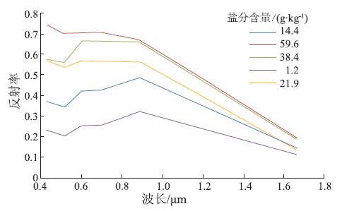
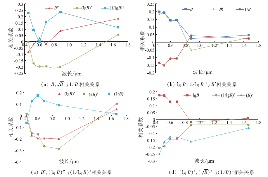
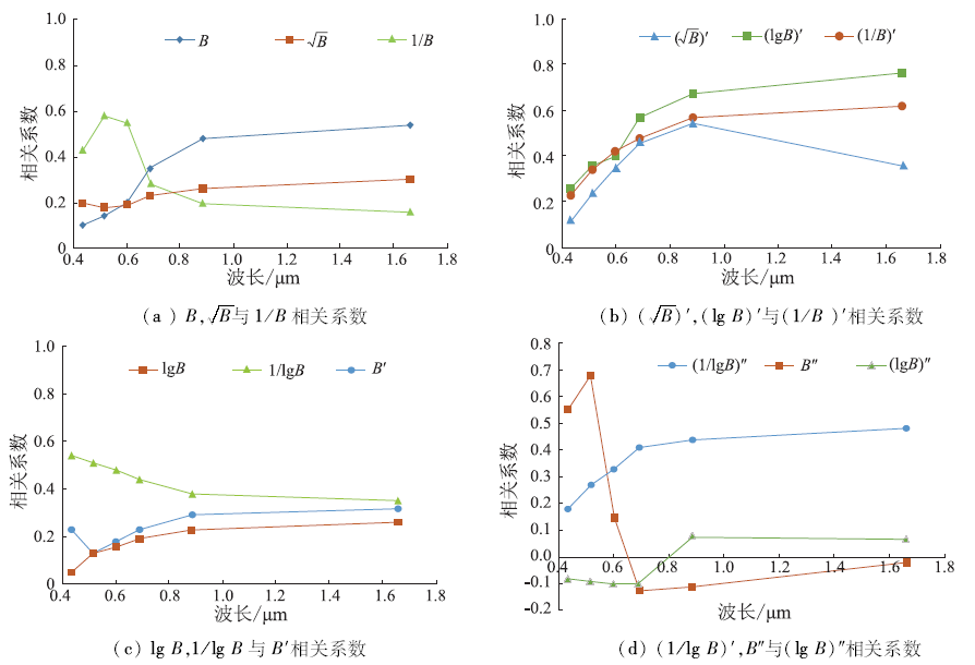
Abstract The purpose of this paper is to improve the precision of salinity monitoring model with Landsat8 OLI multi-spectral images in the oasis of arid area. In this paper, the authors chose the Ebinur Lake region as the study area, and reflectivity of saline soil based on OLI image and spectral reflectivity from resampled ASD data were measured respectively. According to the findings of the correlation analysis of twelve transforms of soil spectral reflectance with soil salt content, multiple stepwise regression analysis algorithm was used. Based on the analysis, the authors chose the most sensitive band ranges to establish a soil salinization monitoring model using the ASD actual measurement data and corrected OLI image inversion of soil salinity. The results show that the soil salt content inversion model based on the measured field spectral is satisfying, the first-order of the logarithm of the reciprocal with the best accuracy and the R2 is 0.779. Spectral reflectivity after resampling data performed better than those monitoring models with OLI spectral data, the coefficient of determination (R2) is raised from 0.28 to 0.777 6, and the RMSE is 0.281. The authors realized the scale transformation of the soil salt content spectral inversion model from field measurements of spectral scales to spectral scale of multi-spectral remote sensing, and the results could provide a theoretical reference for further improvement of the accuracy of quantitative remote sensing monitoring of soil salt content at the regional scale.
|
| Keywords
hyperspectral
Landsat8 OLI image
soil salinization
correlation coefficient
multiple stepwise regression
|
|
|
|
Issue Date: 08 February 2018
|
|
|
| [1] |
文振旺. 新疆土壤地理[M].北京:科学出版社,1965.
|
| [1] |
Wen Z W.Soil Geography of Xinjiang[M].Beijing:Science Press,1965.
|
| [2] |
魏云杰,许模.新疆土壤盐渍化成因及其防治对策研究[J].地球与环境,2005,33(s1):593-597.
|
| [2] |
Wei Y J,Xu M.Study on soil salinization and countermeasures of its prevention in Xinjiang[J].Earth and Environment,2005,33(s1):593-597.
|
| [3] |
丁建丽,姚远,王飞.干旱区土壤盐渍化特征空间建模[J].生态学报,2014,34(16):4620-4631.
|
| [3] |
Ding J L,Yao Y,Wang F.Detecting soil salinization in arid regions using spectral feature space derived from remote sensing data[J].Acta Ecologica Sinica,2014,34(16):4620-4631.
|
| [4] |
田长彦,周宏飞,刘国庆.21世纪新疆土壤盐渍化调控与农业持续发展研究建议[J].干早区地理,2000,23(2):177-181.
|
| [4] |
Tian C Y,Zhou H F,Liu G Q.The proposal on control of soil salinizing and agricultural sustaining developmentn in 21’s century in Xinjiang[J].Arid Land Geography,2000,23(2):177-181.
|
| [5] |
董新光,周金龙,陈跃滨.干旱内陆区水盐监测与模型研究及其应用[M].北京:科学出版社,2007:1-27.
|
| [5] |
Dong X G,Zhou J L,Chen Y B.Monitoring Water and Soil with the Model and Its Application in Arid Inland Area[M].Beijing:Science Press,2007:1-27.
|
| [6] |
Mougenot B,Pouget M,Epema G F.Remote sensing of salt affected soils[J].Remote Sensing Reviews,1993,7(3/4):241-259.
|
| [7] |
彭杰,迟春明,向红英,等.基于连续统去除法的土壤盐分含量反演研究[J].土壤学报,2014,51(3):459-469.
|
| [7] |
Peng J,Chi C M,Xiang H Y,et al.Inversion of soil salt content based on continuum-removal method[J].Acta Pedologica Sinica,2014,51(3):459-469.
|
| [8] |
Farifteh F,Farshad A,George R J.Assessing salt-affected soils using remote sensing,solute modelling,and geophysics[J].Geoderma,2006,130(3/4):191-206.
|
| [9] |
翁永玲,戚浩平,方洪宾,等.基于PLSR方法的青海茶卡―共和盆地土壤盐分高光谱遥感反演[J].土壤学报,2010,47(6):1255-1263.
|
| [9] |
Weng Y L,Qi H P,Fang H B,et al.PLSR-based hyperspectral remote sensing retrieval of soil salinity of Chaka-Gonghe basin in Qinghai Province[J].Acta Pedologica Sinica,2010,47(6):1255-1263.
|
| [10] |
曹雷,丁建丽,玉米提·哈力克,等.基于国产高分一号卫星数据的区域土壤盐渍化信息提取与建模[J].土壤学报,2016,53(6):1399-1409.
|
| [10] |
Cao L,Ding J L,Umut H,et al.Extraction and modeling of regional soil salinization based on data from GF-1 satellite[J].Acta Pedologica Sinica,2016,53(6):1399-1409.
|
| [11] |
Dehaan R L,Taylor G R.Field-derived spectra of salinized soils and vegetation as indicators of irrigation-induced soil salinization[J].Remote Sensing of Environment,2002,80(3):406-417.
|
| [12] |
Farifteh J,Van der Meer F,Atzberger C,et al.Quantitative analysis of salt-affected soil reflectance spectra:A comparison of two adaptive methods(PLSR and ANN)[J].Remote Sensing of Environment,2007,110(1):59-78.
|
| [13] |
阿尔达克·克里木,塔西甫拉提·特依拜,张东,等.基于高光谱的ASTER影像土壤盐分模型校正及验证[J].农业工程学报,2016,32(12):144-150.
|
| [13] |
Kelimu A,Tiyip T,Zhang D,et al.Calibration and validation of soil salinity estimation model based on measured hyperspectral and ASTER image[J].Transactions of the Chinese Society of Agricultural Engineering,2016,32(12):144-150.
|
| [14] |
姚远,丁建丽,阿尔达克·克里木,等.基于实测高光谱和电磁感应数据的区域土壤盐渍化遥感监测研究[J].光谱学与光谱分析,2013,33(7):1917-1921.
|
| [14] |
Yao Y,Ding J L,Kelimu A,et al.Research on remote sensing monitoring of soil salinization based on measured hyperspectral and EM38 data[J].Spectroscopy and Spectral Analysis,2013,33(7):1917-1921.
|
| [15] |
雷磊,塔西甫拉提·特依拜,丁建丽,等.基于HJ-1A高光谱影像的盐渍化土壤信息提取——以渭干河-库车河绿洲为例[J].中国沙漠,2013,33(4):1104-1109.
|
| [15] |
Lei L,Tiyip T,Ding J L,et al.Soil salinization information extraction by using hyperspectral data of HJ-1A HSI:A case study in the oasis of Ugan & Kuqa,Xinjiang,China[J].Journal of Desert Research,2013,33(4):1104-1109.
|
| [16] |
伍漫春. 绿洲区域尺度水盐遥感研究——以渭干河库车河绿洲为例[D].乌鲁木齐:新疆大学,2011.
|
| [16] |
Wu M C.Research on the water-salt of the Oasia at the regional scale by remote sensing[D].Urumchi:Xinjiang University,2011.
|
| [17] |
吴敬禄,刘建军,王苏民,等.近1500年来新疆艾比湖同位素记录的气候环境演化特征[J].第四纪研究,2004,24(5):585-590.
|
| [17] |
Wu J L,Liu J J,Wang S M,et al.Climatic change record from stable isotopes in lake Aibi,Xinjiang during the past 1500 years[J].Quaternary Sciences,2004,24(5):585-590.
|
| [18] |
何学敏,吕光辉,秦璐,等.艾比湖荒漠湿地生态系统非生长季碳通量数据特征[J].生态学报,2014,34(22):6655-6665.
|
| [18] |
He X M,Lü G H,Qin L,et al.Research on data characteristics during non-growing season of desert wetland ecosystem in Ebinur lake[J].Acta Ecologica Sinica,2014,34(22):6655-6665.
|
| [19] |
冉启祥,吕光辉,魏雪峰,等.艾比湖自然保护区土壤酶活性及理化性质[J].干旱区研究,2014,31(4):715-722.
|
| [19] |
Ran Q X,Lü G H,Wei X F,et al.Enzyme activities and physicochemical properties of soils in the Ebinur lake nature reserve in Xinjiang,China[J].Arid Zone Research,2014,31(4):715-722.
|
| [20] |
赵顺阳,王文科.艾比湖流域典型植物生长的水文地质条件研究[J].新疆环境保护,2005,15(1):13-17.
|
| [20] |
Zhao S Y,Wang W K.Research on hydrogeological condition of Aibi lake valley Tipical plant growth[J].Environmental Protection of Xinjiang,2005,15(1):13-17.
|
| [21] |
李慧,蔺启忠,王钦军,等.基于小波包变换和数学形态学结合的光谱去噪方法研究[J].光谱学与光谱分析,2010,30(3):644-648.
|
| [21] |
Li H,Lin Q Z,Wang Q J,et al.Research on spectrum denoising methods based on the combination of wavelet package transformation and mathematical morphology[J].Spectroscopy and Spectral Analysis,2010,30(3):644-648.
|
| [22] |
Palacios-Orueta A,Ustin S L.Multivariate statistical classification of soil spectra[J].Remote Sensing of Environment,1996,57(2):108-118.
|
| [23] |
Kan N M,Sato Y.Monitoring hydro-salinity status and its impact in irrigated semi arid areas using IRS-1B LISS-Ⅱ data[J].Asian Journal of Geoinform,2001,1(3):63-73.
|
| [24] |
李相,丁建丽.基于实测高光谱指数与HSI影像指数的土壤含水量监测[J].农业工程学报,2015,31(19):68-75.
|
| [24] |
Li X,Ding J L.Soil moisture monitoring based on measured hyperspectral index and HSI image index[J].Transactions of the Chinese Society of Agricultural Engineering,2015,31(19):68-75.
|
|
Viewed |
|
|
|
Full text
|
|
|
|
|
Abstract
|
|
|
|
|
Cited |
|
|
|
|
| |
Shared |
|
|
|
|
| |
Discussed |
|
|
|
|
 2018,
Vol. 30
2018,
Vol. 30