|
|
 |
|

|
|
|
Research on fine recognition of site spatial archaeology based on multisource high-resolution data |
SHU Huiqin1,2( ), FANG Junyong1(), LU Peng3, GU Wanfa4, WANG Xiao1, ZHANG Xiaohong1, LIU Xue1, DING Lanpo4 ), FANG Junyong1(), LU Peng3, GU Wanfa4, WANG Xiao1, ZHANG Xiaohong1, LIU Xue1, DING Lanpo4 |
1. Areospace Information Research Institute, China Academy of Sciences, Beijing 100094, China
2. University of Chinese Academy of Sciences, Beijing 100049, China
3. Institute of Geographical Sciences, Henan Academy of Sciences, Zhengzhou 450052, China
4. Zhengzhou Institute of Cultural Relics and Archaeology,Zhengzhou 450000, China |
|
|
|
|
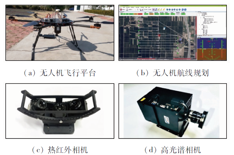
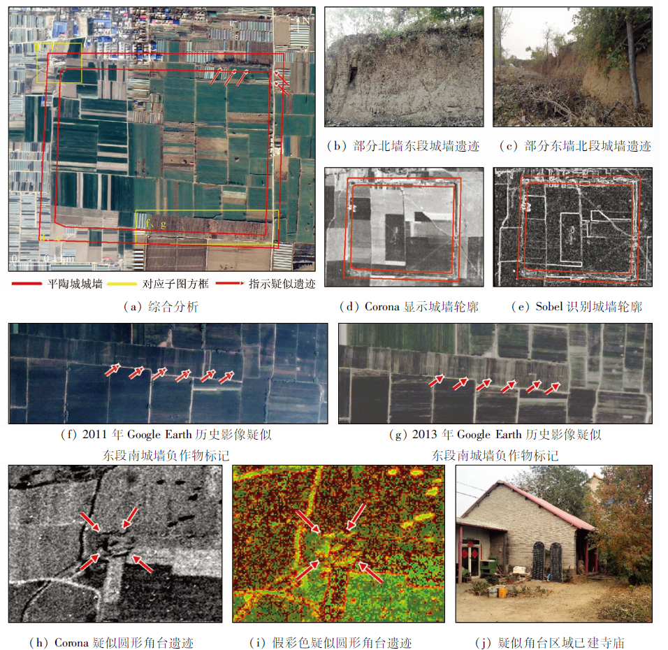
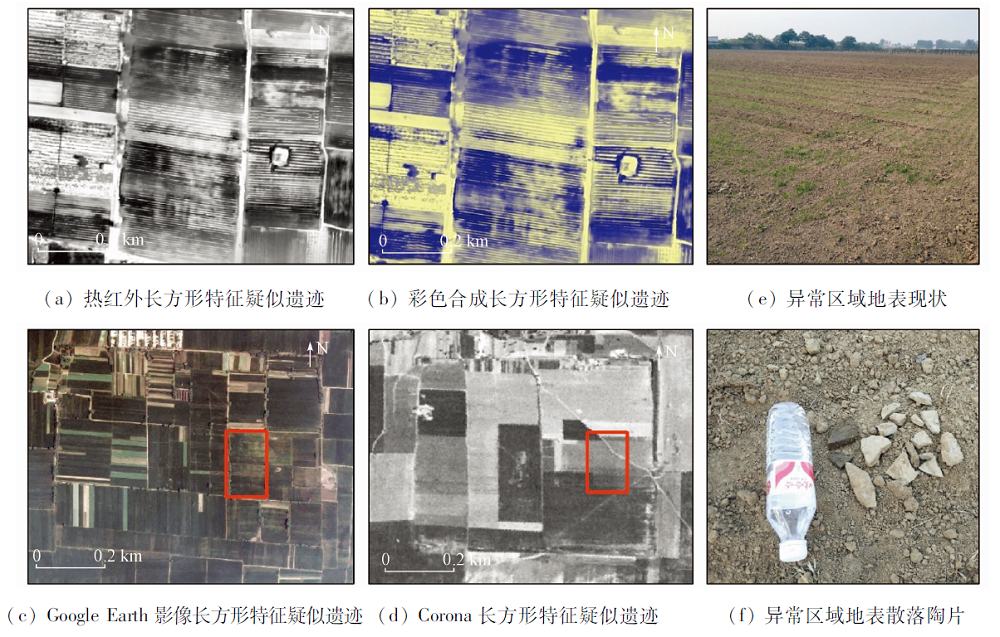
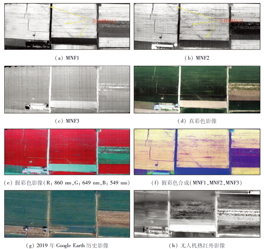
Abstract The ancient city of Pingtao, Zhengzhou City, Henan Province, was an important city in the Eastern Zhou Dynasty and has important historical value. Due to the problems of time-consuming, heavy investment and heavy workload in traditional archaeological investigations, the settlement layout and relic distribution of the old city of Pingtao are still unclear. In this study, the authors selected Corona, Google Earth historical images and aerial thermal infrared images, comparatively analyzed the tonal and texture features on images of different loads, phases and scales, and extracted the archaeological anomalous areas of the Pingtao City site and Dianjuntai site. Suspected ruins such as city walls, gates, corner platforms and rectangular building foundations were discovered, and the spatial structure of the ruins was initially reconstructed based on the identification results. The results of the study show that Corona imagery helps to identify the early appearance of the site, Google Earth historical imagery provides assistance for the detection and extraction of tiny suspected relic features, and aerial thermal infrared imagery can reveal such archeological features as indistinct burial on the ground or optical image. The research proves that the comprehensive utilization of multi-source high-score data can investigate, predict and reconstruct the distribution and spatial structure of the relics, thus providing a reference for further archaeological research and site protection.
|
| Keywords
remote sensing archaeology
site identification
aviation thermal infrared
hyperspectral
Corona
Google Earth
|
|
|
|
Corresponding Authors:
FANG Junyong
E-mail: shuhq521@gmail.com;fangjy@aircas.ac.cn
|
|
Issue Date: 21 July 2021
|
|
|
| [1] |
邓飚, 郭华东. 遥感考古研究综述[J]. 遥感信息, 2010(1):110-116.
|
| [1] |
Deng B, Guo H D. Review of remote sensing archaeological research[J]. Remote Sensing Information, 2010(1):110-116.
|
| [2] |
Noviello M, Ciminale M,de Pasquale V.Combined application of pansharpening and enhancement metho-ds to improve archaeological cropmark visibility and identification in QuickBird imagery:Two case studies from Apulia,Southern Italy[J]. Journal of Archaeological Science, 2013, 40(10):3604-3613.
doi: 10.1016/j.jas.2013.04.013
url: https://linkinghub.elsevier.com/retrieve/pii/S0305440313001374
|
| [3] |
Masini N, Lasaponara R, Orefici G. Addressing the challenge of detecting archaeological adobe structures in Southern Peru using QuickBird imagery[J]. Journal of Cultural Heritage, 2009, 10(s1):3-9.
|
| [4] |
Masini N, Lasaponara R. Investigating the spectral capability of QuickBird data to detect archaeological remains buried under vegetated and not vegetated areas[J]. Journal of Cultural Heritage, 2007, 8(1):53-60.
doi: 10.1016/j.culher.2006.06.006
url: https://linkinghub.elsevier.com/retrieve/pii/S1296207406001087
|
| [5] |
Masini N, Rosa L. Satellite-based recognition of landscape archaeological features related to ancient hum-an transformation[J]. Journal of Geophysics and Engineering, 2006, 3(3):230-235.
doi: 10.1088/1742-2132/3/3/004
url: https://academic.oup.com/jge/article/3/3/230-235/5127593
|
| [6] |
Garrison T G, Houston S D, Golden C, et al. Evaluating the use of IKONOS satellite imagery in lowland Maya settlement archaeology[J]. Journal of Archaeological Science, 2008, 35(10):2770-2777.
doi: 10.1016/j.jas.2008.05.003
url: https://linkinghub.elsevier.com/retrieve/pii/S0305440308001088
|
| [7] |
Traviglia A, Cottica D. Remote sensing applications and archaeological research in the Northern Lagoon of Venice:The case of the lost settlement of Constanciacus[J]. Journal of Archaeological Science, 2011, 38(9):2040-2050.
doi: 10.1016/j.jas.2010.10.024
url: https://linkinghub.elsevier.com/retrieve/pii/S0305440310003845
|
| [8] |
Luo L, Wang X Y, Guo H D, et al. Airborne and spaceborne remote sensing for archaeological and cult-ural heritage applications:A review of the century (1907—2017)[J]. Remote Sensing of Environment, 2019(232):508-542.
|
| [9] |
Agapiou A, Alexakis D D, Sarris A, et al. Colour to greyscale pixels:Re-seeing greyscale archived aerial photographs and declassified satellite CORONA images based on image fusion techniques[J]. Archaeol-ogical Prospection, 2016, 23(4):231-241.
|
| [10] |
Philip G, Donoghue D, Beck A, et al. CORONA satellite photography:An archaeological application from the Middle East[J]. Antiquity, 2002, 76(291):109-118.
doi: 10.1017/S0003598X00089869
url: https://www.cambridge.org/core/product/identifier/S0003598X00089869/type/journal_article
|
| [11] |
Shaw J. A 'reflexive' multi-stage survey methodology for historical landscape research in Central India:Fieldwalking,local knowledge,and satellite imagery as archaeological site prospection and mapping tools in the Sanchi Survey Project[J]. Current Science, 2017, 113(10):1918-1933
doi: 10.18520/cs/v113/i10/1918-1933
url: http://www.currentscience.ac.in/Volumes/113/10/1918.pdf
|
| [12] |
于丽君, 聂跃平, 杨林, 等. 新疆轮台奎玉克协海尔古城空间考古综合研究[J]. 遥感技术与应用, 2020, 35(1):255-266.
|
| [12] |
Yu L J, Nie Y P, Yang L, et al. A comprehensive spatial archaeological study of the Koyuk Shahri ancient City in Xinjiang[J]. Remote Sensing Technology and Application, 2020, 35(1):255-266.
|
| [13] |
Jason U. CORONA satellite photography and ancient road networks:A northern mesopotamian case study[J]. Antiquity, 2003, 77(295):102-115.
doi: 10.1017/S0003598X00061391
url: https://www.cambridge.org/core/product/identifier/S0003598X00061391/type/journal_article
|
| [14] |
Francesc C, Marco M, Nikolaos G, et al. CORONA photographs in monsoonal semi-arid environments:Addressing archaeological surveys and historic landscape dynamics over North Gujarat,India[J]. Archaeological Prospection, 2015, 22(2):75-90.
doi: 10.1002/arp.v22.2
url: http://doi.wiley.com/10.1002/arp.v22.2
|
| [15] |
Sabine R, Andrey B, Dmitriy K. Caucasia top-down:Remote sensing data for survey in a high altitude mountain landscape[J]. Quaternary International, 2016, 402(402):46-60.
doi: 10.1016/j.quaint.2015.10.106
url: https://linkinghub.elsevier.com/retrieve/pii/S1040618215010927
|
| [16] |
Goossens R, Wulf A D, Bourgeois J, et al. Satellite imagery and archaeology:The example of CORONA in the Altai Mountains[J]. Journal of Archaeological Science, 2006, 33(6):745-755
doi: 10.1016/j.jas.2005.10.010
url: https://linkinghub.elsevier.com/retrieve/pii/S0305440305002220
|
| [17] |
Karim S, Xavier R.Google Earth, GIS and stone-walled structures in southern Gauteng,South Africa[J]. Journal of Archaeological Science, 2012, 39(4):1034-1042.
doi: 10.1016/j.jas.2011.11.024
url: https://linkinghub.elsevier.com/retrieve/pii/S0305440311004389
|
| [18] |
Heather P. Google Earth shows clandestine worlds[J]. Science, 2010, 329(5995):1008-1009.
doi: 10.1126/science.329.5995.1008
pmid: 20798294
|
| [19] |
Luo L, Wang X Y, Liu C S, et al. Integrated RS,GIS and GPS approaches to archaeological prospecting in the Hexi Corridor,NW China:A case study of the royal road to ancient Dunhuang[J]. Journal of Archaeological Science, 2014(50):178-190.
|
| [20] |
Carrie H. A malarial-ridden swamp:Using Google Earth Pro and Corona to access the southern Balikh valley,Syria[J]. Journal of Archaeological Science, 2013, 40(4):1975-1987.
doi: 10.1016/j.jas.2012.11.017
url: https://linkinghub.elsevier.com/retrieve/pii/S0305440312005110
|
| [21] |
Kaimaris D, Georgoula O, Patias P, et al. Comparative analysis on the archaeological content of imagery from Google Earth[J]. Journal of Cultural Heritage, 2011, 12(3):263-269.
doi: 10.1016/j.culher.2010.12.007
url: https://linkinghub.elsevier.com/retrieve/pii/S1296207411000069
|
| [22] |
Kennedy D, Bishop M C. Google earth and the archaeology of Saudi Arabia:A case study from the Jeddah area[J]. Journal of Archaeological Science, 2011, 38(6):1284-1293.
doi: 10.1016/j.jas.2011.01.003
url: https://linkinghub.elsevier.com/retrieve/pii/S030544031100015X
|
| [23] |
Dimitris K, Petros P, Olga G. Google Earth revisited: Case studies at the Plain of Larissa (Thessaly,Greece)[J]. International Journal of Computational Methods in Heritage Science (IJCMHS), 2017, 1(1):77-88.
|
| [24] |
Kaimaris D, Georgoula O, Patias P, et al. Comparative analysis on the archaeological content of imagery from Google Earth[J]. Journal of Cultural Heritage, 2011, 12(3):263-269.
doi: 10.1016/j.culher.2010.12.007
url: https://linkinghub.elsevier.com/retrieve/pii/S1296207411000069
|
| [25] |
Périsset M C, Tabbagh A. Interpretation of thermal prospection on bare soils[J]. Archaeometry, 1981, 23(2):169-187.
doi: 10.1111/arch.1981.23.issue-2
url: http://www.blackwell-synergy.com/toc/arch/23/2
|
| [26] |
Kvamme K L. Archaeological prospecting at the Double Ditch State Historic Site,North Dakota,USA[J]. Archaeological Prospection, 2008, 15(1):62-79.
doi: 10.1002/(ISSN)1099-0763
url: http://doi.wiley.com/10.1002/%28ISSN%291099-0763
|
| [27] |
Casana J, Kantner J, Wiewel A, et al. Archaeological aerial thermography:A case study at the Chaco-era Blue J community,New Mexico[J]. Journal of Archaeological Science, 2014(45):207-219.
|
| [28] |
Casana J, Wiewel A, Cool A, et al. Archaeological aerial thermography in theory and practice[J]. Advances in Archaeological Practice, 2017, 5(4):1-18.
doi: 10.1017/aap.2016.7
url: https://www.cambridge.org/core/product/identifier/S2326376816000073/type/journal_article
|
| [29] |
Madeleine M L, Jesse C, Schurr M R, et al. Detecting prehistoric landscape features using thermal,multispectral,and historical imagery analysis at Midewin National Tallgrass Prairie,Illinois[J]. Journal of Archaeological Science:Reports, 2018(21):450-459.
|
| [30] |
Syed A, William S, Jane D. Finding archaeological cropmarks:A hyperspectral approach[P]. SPIE Remote Sensing, 2007.
|
| [31] |
Cerra D, Athos A, et al. An Objective Assessment of Hyperspectral Indicators for the Detection of Buried Archaeological Relics[J]. Remote Sensing, 2018, 10(4):500-525.
doi: 10.3390/rs10040500
url: http://www.mdpi.com/2072-4292/10/4/500
|
| [32] |
Athos A, Diofantos G, et al. Observatory validation of Neolithic tells (“Magoules”) in the Thessalian plain,central Greece,using hyperspectral spectroradiometric data[J]. Journal of Archaeological Science, 2012, 39(5):1499-1512.
doi: 10.1016/j.jas.2012.01.001
url: https://linkinghub.elsevier.com/retrieve/pii/S0305440312000027
|
| [33] |
Stephen H, Thomas E, Ian W. Prospects and problems in the use of hyperspectral imagery for archaeological remote sensing:A case study from the Faynan copper mining district,Jordan[J]. Journal of Archaeolo-gical Science, 2011, 39(2):407-420.
|
| [34] |
常维华. 荥阳文物志[M]. 郑州: 中州古籍出版社, 2011:63-64.
|
| [34] |
Chang W H. ingyang cultural relics[M]. Zhengzhou: Zhongzhou Ancient Books Publishing House, 2011:63-64.
|
| [35] |
张立东. 濮阳卫城郭门探寻[J]. 华夏考古, 2019(4):57-63.
|
| [35] |
Zhang L D. Exploration of the gate of Puyang Guard City[J]. Chinese Archaeology, 2019(4):57-63.
|
| [36] |
张立东, 杨子彦. 郑州商城城门探寻[J]. 江汉考古, 2015(4):79-85.
|
| [36] |
Zhang L D, Yang Z Y. An exploration the gate of Zhengzhou Shang City Site[J]. Huaxia Archaeology, 2015(4):57-63.
|
|
Viewed |
|
|
|
Full text
|
|
|
|
|
Abstract
|
|
|
|
|
Cited |
|
|
|
|
| |
Shared |
|
|
|
|
| |
Discussed |
|
|
|
|
 2021,
Vol. 33
2021,
Vol. 33