|
|
|
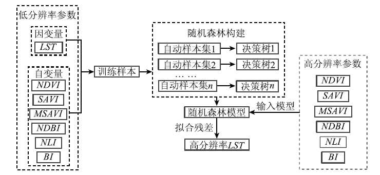
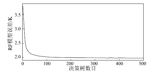
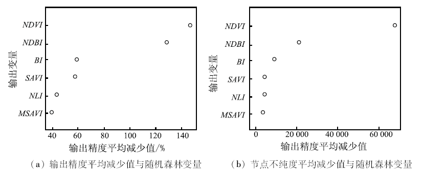
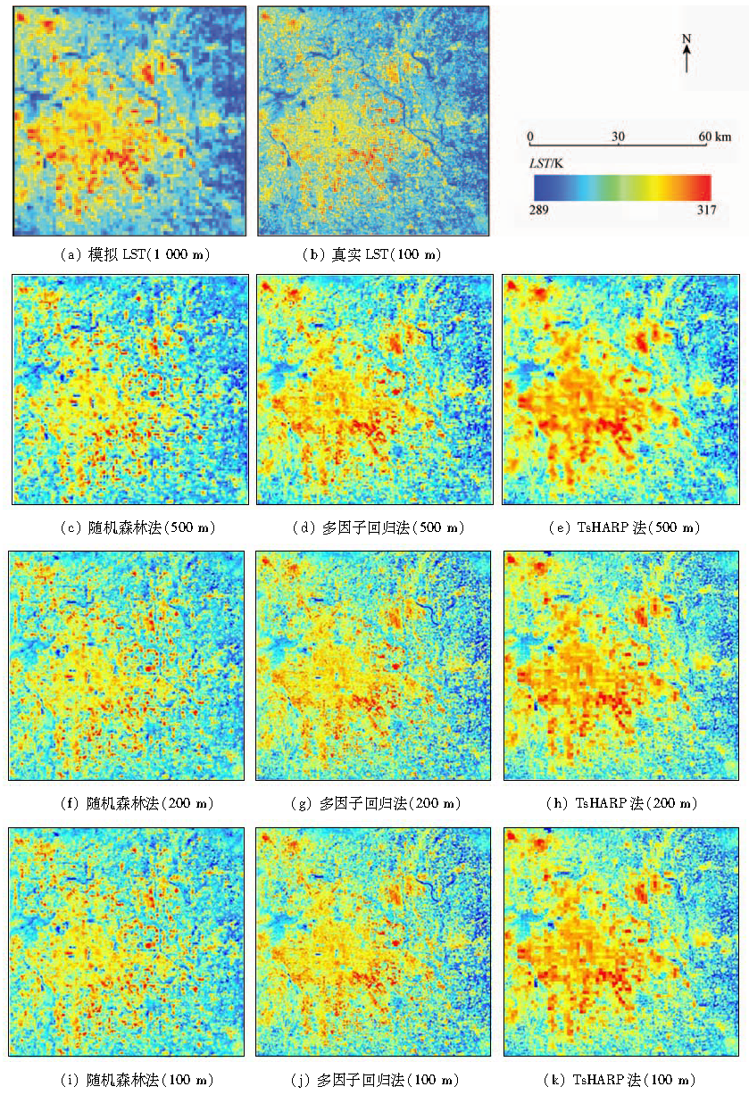
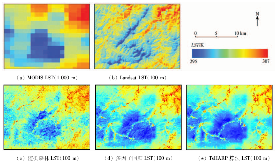
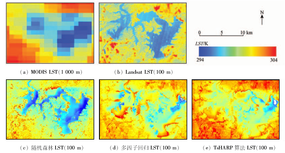
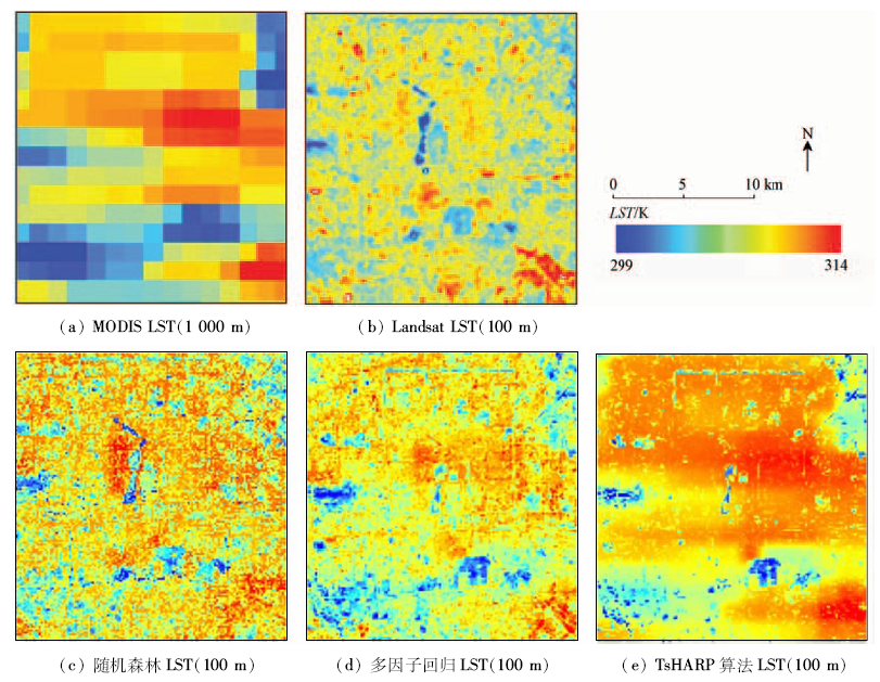
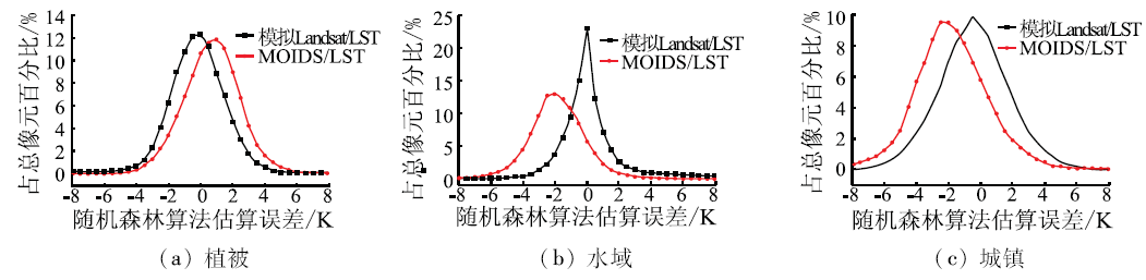
Abstract Land surface temperature(LST)is an important parameter in the model of energy balance of the earth surface. The enhanced spatial resolution of high temporal resolution of remote sensing surface temperature can be realized by downscaling algorithm, which is of great significance for monitoring the spatial and temporal distribution of the LST. In this paper, Beijing City was taken as the study area, and the LST with 100 m spatial resolution was retrieved by using Landsat8 OLI/TIRS data through improved mono-window(IMW)algorithm,which was used as validation data. Besides,the normalized difference vegetation index(NDVI),normalized difference built-up index(NDBI)and other remote sensing index were calculated and simulated to the spatial resolution of 1 000 m, which was united with the MODIS/LST with the spatial resolution of 1 000 m to be input into the random forest(RF)model to acquire downscaled LST(100 m). Meanwhile, the downscaled results retrieved by RF algorithm were compared with the two commonly used methods of downscaling, multi factor regression method and LST sharpening algorithm based on vegetation index (TsHARP). The results show that, with the simulated Landsat/LST as the data source, the RMSE of downscaling LST retrieved by RF was 2.01 K, and the RMSE was improved by 0.16 K and 0.44 K compared with the multi factor regression method and TsHARP algorithm respectively. For the MODIS/LST, the RMSE of downscaling LST retrieved by RF was 2.29 K, and the RMSE was improved by 0.42 K and 0.50 K compared with multi factor regression method and TsHARP algorithm respectively. For different land surface types, the effects of RF downscaling algorithm are different. The effect of high vegetation coverage area is the best, and the RMSE is 1.81 K. Due to the spatial heterogeneity of the urban surface, the RMSEhas reached a maximum of 2.75 K.
|
| Keywords
remote sensing
land surface temperature(LST)
downscale
random forest(RF)
|
|
|
|
Issue Date: 08 February 2018
|
|
|
| [1] |
Kustas W,Anderson M.Advances in thermal infrared remote sensing for land surface modeling[J].Agricultural and Forest Meteorology,2009,149(12):2071-2081.
|
| [2] |
Anderson M C,Allen R G,Morse A,et al.Use of Landsat thermal imagery in monitoring evapotranspiration and managing water resources[J].Remote Sensing of Environment,2012,122:50-65.
|
| [3] |
宋春桥,游松财,刘高焕,等.基于TVDI的藏北地区土壤湿度空间格局[J].地理科学进展,2011,30(5):569-576.
|
| [3] |
Song C Q,You S C,Liu G H,et al.The spatial pattern of soil moisture in northern Tibet based on TVDI method[J].Progress in Geography,2011,30(5):569-576.
|
| [4] |
叶彩华,刘勇洪,刘伟东,等.城市地表热环境遥感监测指标研究及应用[J].气象科技,2011,39(1):95-101.
|
| [4] |
Ye C H,Liu Y H,Liu W D,et al.Research on urban surface heat environment monitoring indexes and its application[J].Meteorological Science and Technology,2011,39(1):95-101.
|
| [5] |
Zhan W F,Chen Y H,Zhou J,et al.Disaggregation of remotely sensed land surface temperature:Literature survey,taxonomy,issues,and caveats[J].Remote Sensing of Environment,2013,131:119-139.
|
| [6] |
Kustas W P,Norman J M,Anderson M C,et al.Estimating subpixel surface temperatures and energy fluxes from the vegetation index-radiometric temperature relationship[J].Remote Sensing of Environment,2003,85(4):429-440.
|
| [7] |
Agam N,Kustas W P,Anderson M C,et al.A vegetation index based technique for spatial sharpening of thermal imagery[J].Remote Sensing of Environment,2007,107(4):545-558.
|
| [8] |
Essa W,Verbeiren B,van der Kwast J, et al.Evaluation of the DisTrad thermal sharpening methodology for urban areas[J].International Journal of Applied Earth Observation and Geoinformation,2012,19:163-172.
|
| [9] |
Essa W,van der Kwast J,Verbeiren B,et al.Downscaling of thermal images over urban areas using the land surface temperature-impervious percentage relationship[J].International Journal of Applied Earth Observation and Geoinformation,2013,23:95-108.
|
| [10] |
Zhu S Y,Guan H,Millington A C,et al.Disaggregation of land surface temperature over a heterogeneous urban and surrounding suburban area:A case study in Shanghai,China[J].International Journal of Remote Sensing,2013,34(5):1707-1723.
|
| [11] |
Wang F,Qin Z H,Li W J,et al.An efficient approach for pixel decomposition to increase the spatial resolution of land surface temperature images from MODIS thermal infrared band data[J].Sensors,2015,15(1):304-330.
|
| [12] |
Bindhu V M,Narasimhan B,Sudheer K P.Development and verification of a non-linear disaggregation method(NL-DisTrad) to downscale MODIS land surface temperature to the spatial scale of Landsat thermal data to estimate evapotranspiration[J].Remote Sensing of Environment,2013,135:118-129.
|
| [13] |
Hutengs C,Vohland M.Downscaling land surface temperatures at regional scales with random forest regression[J].Remote Sensing of Environment,2016,178:127-141.
|
| [14] |
Wang F,Qin Z H,Song C Y,et al.An improved mono-window algorithm for land surface temperature retrieval from Landsat8 thermal infrared sensor data[J].Remote Sensing,2015,7(4):4268-4289.
|
| [15] |
王祎婷,谢东辉,李亚惠.光谱指数趋势面的城市地表温度降尺度转换[J].遥感学报,2014,18(6):1169-1181.
|
| [15] |
Wang Y T,Xie D H,Li Y H.Downscaling remotely sensed land surface temperature over urban areas using trend surface of spectral index[J].Journal of Remote Sensing,2014,18(6):1169-1181.
|
| [16] |
聂建亮,武建军,杨曦,等.基于地表温度-植被指数关系的地表温度降尺度方法研究[J].生态学报,2011,31(17):4961-4969.
|
| [16] |
Nie J L,Wu J J,Yang X,et al.Downscaling land surface temperature based on relationship between surface temperature and vegetation index[J].Acta Ecologica Sinica,2011,31(17):4961-4969.
|
| [17] |
全金玲,占文凤,陈云浩,等.遥感地表温度降尺度方法比较——性能对比及适应性评价[J].遥感学报,2013,17(2):361-387.
|
| [17] |
Quan J L,Zhan W F,Chen Y H,et al.Downscaling remotely sensed land surface temperatures:A comparison of typical methods[J].Journal of Remote Sensing,2013,17(2):361-387.
|
| [18] |
Rouse J W Jr,Haas R H,Schell J A,et al.Monitoring vegetation systems in the Great Plains with ERTS[C]//Third Earth Resources Technology Satellite-1 Symposium.Washington,D.C:NASA,1974:309.
|
| [19] |
Huete A R.A soil-adjusted vegetation index(SAVI)[J].Remote Sensing of Environment,1988,25(3):295-309.
|
| [20] |
Qi J,Chehbouni A,Huete A R,et al.A modified soil adjusted vegetation index[J].Remote Sensing of Environment,1994,48(2):119-126.
|
| [21] |
Goel N S,Qin W H.Influences of canopy architecture on relationships between various vegetation indices and LAI and Fpar:A computer simulation[J].Remote Sensing Reviews,1994,10(4):309-347.
|
| [22] |
Zha Y,Gao J,Ni S.Use of normalized difference built-up index in automatically mapping urban areas from TM imagery[J].International Journal of Remote Sensing,2003,24(3):583-594.
|
| [23] |
吴志杰,赵书河.基于TM图像的“增强的指数型建筑用地指数”研究[J].国土资源遥感,2012,24(2):50-55.doi:10.6046/gtzyyg.2012.02.10.
|
| [23] |
Wu Z J,Zhao S H.A study of enhanced index-based built-up index based on Landsat TM imagery[J].Remote Sensing for Land and Resources,2012,24(2):50-55.doi:10.6046/gtzyyg.2012.02.10.
|
| [24] |
Breiman L.Random forests[J].Machine Learning,2001,45(1):5-32.
|
|
Viewed |
|
|
|
Full text
|
|
|
|
|
Abstract
|
|
|
|
|
Cited |
|
|
|
|
| |
Shared |
|
|
|
|
| |
Discussed |
|
|
|
|
 2018,
Vol. 30
2018,
Vol. 30
 ), Shanyou ZHU(