|
|
 |
|

|
|
|
Research and development of automatic detection technologies for changes in vegetation regions based on correlation coefficients and feature analysis |
PAN Jianping1( ), XU Yongjie1(), LI Mingming1, HU Yong2, WANG Chunxiao3 ), XU Yongjie1(), LI Mingming1, HU Yong2, WANG Chunxiao3 |
1. School of Civil Engineering, Chongqing Jiaotong University, Chongqing 400074, China
2. Chongqing Institute of Surveying and Monitoring for Planning and Natural Resources, Chongqing 401123, China
3. Hainan Basic Geographic Information Center, Ministry of Natural Resources, Haikou 570203, China |
|
|
|
|
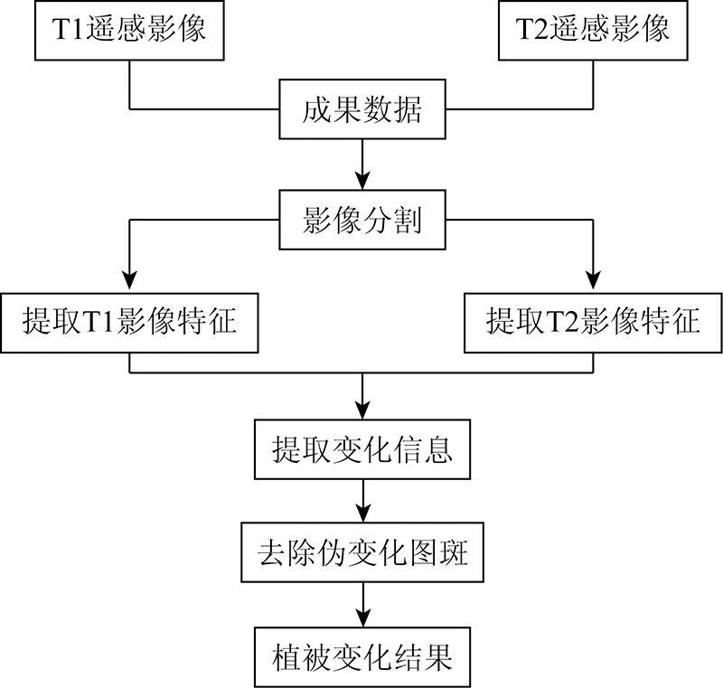
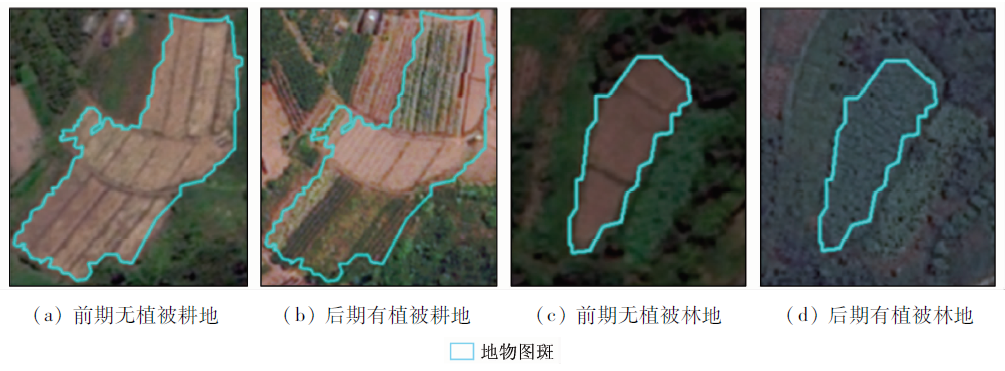
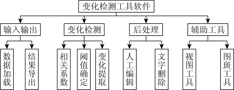
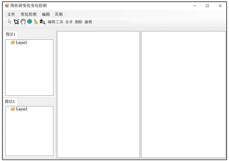
Abstract Surface change detection is an important component of the applications of remote sensing big data. However, it is essentially subject to manual interactive interpretation in actual production. With this regard, this paper developed an application method and software for the automatic detection of changes in vegetation regions on a polygon scale using correlation coefficients and feature analysis. The details are as follows. Correlation coefficients of surface features were constructed using spectral and textural features, and then the changes in vegetation regions were detected using the similarity measurement method. According to the analysis of spectral differences between the vegetation and other types of surface features, the red band ratio was selected to remove spurious changes. Finally, the change detection software was designed and developed using the.NET framework and the ArcGIS Engine component library for secondary development. Test data were imported into the software for change detection. The test results show the accuracy rate and omission rate of the software in the change detection were 94.3% and 8.5%, respectively. Furthermore, the software has a higher automatic level compared to manual interactive interpretation. In conclusion, the method and software developed in this study can be widely applied.
|
| Keywords
change detection
correlation coefficient
vegetation
patch
feature analysis
|
|
|
|
Corresponding Authors:
XU Yongjie
E-mail: 6370554@qq.com;1768335576@qq.com
|
|
Issue Date: 14 March 2022
|
|
|
| [1] |
李亮, 舒宁, 王凯, 等. 融合多特征的遥感影像变化检测方法[J]. 测绘学报, 2014, 43(9):945-953.
|
| [1] |
Li L, Shu N, Wang K, et al. Change dectection method for remote sensing images based on multi-features fusion[J]. Acta Geodaetica et Cartographica Sinica, 2014, 43(9):945-953.
|
| [2] |
徐锐, 余小于, 张驰, 等. 融合Unet网络和IR-MAD的建筑物变化检测方法[J]. 自然资源遥感, 2020, 32(4):90-96.doi: 10.6046/gtzyyg.2020.04.13.
doi: 10.6046/gtzyyg.2020.04.13
|
| [2] |
Xu R, Yu X Y, Zhang C, et al. Building change detection method combining Unet and IR-MAD[J]. Remote Sensing for Land and Resources, 2020, 32(4):90-96.doi: 10.6046/gtzyyg.2020.04.13.
doi: 10.6046/gtzyyg.2020.04.13
|
| [3] |
航天宏图. 耕地保护“非农化”“非粮化”——政策篇[EB/OL].(2020-12-18). http://www.piesat.cn/news/dongtai/1801.html.
url: http://www.piesat.cn/news/dongtai/1801.html.
|
| [3] |
PIESAT. Cultivated land protection “non-agriculturalization” and “non-graining”-policy chapter[EB/OL].(2020-12-18). http://www.piesat.cn/news/dongtai/1801.html.
url: http://www.piesat.cn/news/dongtai/1801.html.
|
| [4] |
王晓东, 何浩, 侯东, 等. 基于TM图像的农业区域植被覆盖变化检测[J]. 自然资源遥感, 2012, 93(2):92-97.doi: 10.6046/gtzyyg.2012.02.17.
doi: 10.6046/gtzyyg.2012.02.17
|
| [4] |
Wang X D, He H, Hou D, et al. Vegetation cover change detection in the cropping area based on TM image[J]. Remote Sensing for Land and Resources, 2012, 93(2):92-97.doi: 10.6046/gtzyyg.2012.02.17.
doi: 10.6046/gtzyyg.2012.02.17
|
| [5] |
梅树红, 范城城, 廖永生, 等. 结合光谱和纹理特征的林地变更检测[J]. 测绘通报, 2019(8):140-143.
|
| [5] |
Mei S H, Fan C C, Liao Y S, et al. Forestland change detection based on spectral and texture features[J]. Bulletin of Surveying and Mapping, 2019(8):140-143.
|
| [6] |
Nielsen A A, Conradsen K, Simpson J J. Multivariate alteration detection (MAD) and MAF postprocessing in multispectral,bitemporal image data:New approaches to change detection studies[J]. Remote Sensing of Environment, 1998, 64(1):1-19.
doi: 10.1016/S0034-4257(97)00162-4
url: https://linkinghub.elsevier.com/retrieve/pii/S0034425797001624
|
| [7] |
Nielsen A A. The regularized iteratively reweighted MAD method for change detection in multi- and hyperspectral data[J]. IEEE Transactions on Image Processing, 2007, 16(2):463-478.
doi: 10.1109/TIP.2006.888195
url: http://ieeexplore.ieee.org/document/4060945/
|
| [8] |
黄恺, 毛政元. 基于时空自相关的植被变化检测[J]. 遥感信息, 2016, 31(3):37-44.
|
| [8] |
Huang K, Mao Z Y. Vegetation change detection using spatiotemporal autocorrelation index[J]. Remote Sensing Information, 2016, 31(3):37-44.
|
| [9] |
李雪, 舒宁, 王琰. 利用向量相似性进行基于像斑的土地利用变化检测[J]. 遥感信息, 2009(6):7-10,19.
|
| [9] |
Li X, Shu N, Wang Y. Segment-based land use change detection using the similarity of vector[J]. Remote Sensing Information, 2009(6):7-10,19.
|
| [10] |
冯林艳, 谭炳香, 王晓慧, 等. 基于分布函数的对象级森林变化快速检测[J]. 自然资源遥感, 2020, 32(2):73-80.doi: 10.6046/gtzyyg.2020.02.10.
doi: 10.6046/gtzyyg.2020.02.10
|
| [10] |
Feng L Y, Tan B X, Wang X H, et al. Object-oriented rapid forest change detection based on distribution function[J]. Remote Sensing for Land and Resources, 2020, 32(2):73-80.doi: 10.6046/gtzyyg.2020.02.10.
doi: 10.6046/gtzyyg.2020.02.10
|
| [11] |
张春森, 吴蓉蓉, 李国君, 等. 面向对象的高空间分辨率遥感影像箱线图变化检测方法[J]. 自然资源遥感, 2020, 32(2):19-25.doi: 10.6046/gtzyyg.2020.02.03.
doi: 10.6046/gtzyyg.2020.02.03
|
| [11] |
Zhang C S, Wu R R, Li G J, et al. High resolution remote sensing image object change detection based on box-plot method[J]. Remote Sensing for Land and Resources, 2020, 32(2):19-25.doi: 10.6046/gtzyyg.2020.02.03.
doi: 10.6046/gtzyyg.2020.02.03
|
| [12] |
Walter V. Object-based classification of remote sensing data for change detection[J]. ISPRS Journal of Photogrammetry and Remote Sensing, 2004:225-238.
|
| [13] |
Zomeni M, Tzanopoulos J, Pantis J D. Historical analysis of landscape change using remote sensing techniques:An explanatory tool for agricultural transformation in Greek rural areas[J]. Landscape and Urban Planning, 2008, 86(1):38-46.
doi: 10.1016/j.landurbplan.2007.12.006
url: https://linkinghub.elsevier.com/retrieve/pii/S0169204607003027
|
| [14] |
王琰, 舒宁, 龚龑. 高分辨率遥感影像土地利用变化检测方法研究[J]. 自然资源遥感, 2012, 92(1):43-47.doi: 10.6046/gtzyyg.2012.01.08.
doi: 10.6046/gtzyyg.2012.01.08
|
| [14] |
Wang Y, Shu N, Gong Y. A study of land use change detection based on high resolution remote sensing images[J]. Remote Sensing for Land and Resources, 2012, 92(1):43-47.doi: 10.6046/gtzyyg.2012.01.08.
doi: 10.6046/gtzyyg.2012.01.08
|
| [15] |
佃袁勇, 方圣辉, 姚崇怀. 多尺度分割的高分辨率遥感影像变化检测[J]. 遥感学报, 2016, 20(1):129-137.
|
| [15] |
Dian Y Y, Fang S H, Yao C H. Change detection for high-resolution images using multilevel segment method[J]. Journal of Remote Sensing, 2016, 20(1):129-137.
|
| [16] |
眭海刚, 冯文卿, 李文卓, 等. 多时相遥感影像变化检测方法综述[J]. 武汉大学学报(信息科学版), 2018, 43(12):1885-1898.
|
| [16] |
Sui H G, Feng W Q, Li W Z, et al. Review of change detection methods for multi-temporal remote sensing imagery[J]. Geomatics and Information Science of Wuhan University, 2018, 43(12):1885-1898.
|
| [17] |
王佳. 基于时空自相关的建筑物变化检测[J]. 测绘与空间地理信息, 2020, 43(2):44-48.
|
| [17] |
Wang J. Building change detection based on spatio-temporal autocorrelation[J]. Geomatics and Spatial Information Technology, 2020, 43(2):44-48.
|
| [18] |
王晓慧, 谭炳香, 李世明, 等. 基于面向对象多特征变化向量分析法的森林资源变化检测[J]. 林业科学研究, 2021, 34(1):98-105.
|
| [18] |
Wang X H, Tan B X, Li S M, et al. Object-oriented forest change detection based on multi-featurechange vector analysis[J]. Forest Research, 2021, 34(1):98-105.
|
| [19] |
佟国峰, 李勇, 丁伟利, 等. 遥感影像变化检测算法综述[J]. 中国图象图形学报, 2015, 20(12):1561-1571.
|
| [19] |
Tong G F, Li Y, Ding W L, et al. Review of remote sensing image change detection[J]. Journal of Image and Graphics, 2015, 20(12):1561-1571.
|
| [20] |
宋翔, 颜长珍. 基于知识库的像斑光谱向量相似度土地覆盖变化检测方法[J]. 生态学报, 2014, 34(24):7175-7180.
|
| [20] |
Song X, Yan C Z. Land cover change detection using segment similarity of spectrum vector based on knowledge base[J]. Acta Ecologica Sinica, 2014, 34(24):7175-7180.
|
| [21] |
潘建平, 张定凯, 徐正宣, 等. 面向地理国情监测的植被区域变化发现研究——以重庆市璧山区为例[J]. 计算机应用与软件, 2020, 37(6):114-118,141.
|
| [21] |
Pan J P, Zhang D K, Xu Z X, et al. Vegetation region change discovery for national geographical conditions monitoring:Taking Bishan District in Chongqing as an example[J]. Computer Applications and Software, 2020, 37(6):114-118,141.
|
| [22] |
杨晟, 李学军, 刘涛, 等. 高分辨率遥感影像匹配中的相似性度量综述[J]. 测绘与空间地理信息, 2013, 36(5):16-21,25,28.
|
| [22] |
Yang S, Li X J, Liu T, et al. A review on matching and similarity measures for high resolution remote sensing imagery[J]. Geomatics and Spatial Information Technology, 2013, 36(5):16-21,25, 28.
|
| [23] |
Shabnam J, Mohammad R, Fatemeh F, et al. Multispectral change detection using multivariate Kullback-Leibler distance[J]. Photogrammetry and Remote Sensing, 2019(147):163-177.
|
| [24] |
韩鹏鹏, 黄进良, 王立辉, 等. 长汀县土地覆被变化检测及植被演替趋势监测[J]. 测绘科学, 2014, 39(4):55-60.
|
| [24] |
Han P P, Huang J L, Wang L H, et al. Change detection of land cover and trend monitoring of vegetation succession for Changting County[J]. Science of Surveying and Mapping, 2014, 39(4):55-60.
|
| [25] |
金靖. 基于ArcGIS_Engine的地理信息系统二次开发原理和方法[J]. 测绘与空间地理信息, 2012, 35(3):46-49.
|
| [25] |
Jin J. The principle and method of secondary developmentof GIS based on ArcGIS Engine[J]. Geomatics and Spatial Information Technology, 2012, 35(3):46-49.
|
|
Viewed |
|
|
|
Full text
|
|
|
|
|
Abstract
|
|
|
|
|
Cited |
|
|
|
|
| |
Shared |
|
|
|
|
| |
Discussed |
|
|
|
|
 2022,
Vol. 34
2022,
Vol. 34