|
|
 |
|

|
|
|
Fine extraction of urban villages in provincial capitals based on multivariate data |
FENG Dongdong1,2,3( ), ZHANG Zhihua1,2,3(), SHI Haoyue1,2,3 ), ZHANG Zhihua1,2,3(), SHI Haoyue1,2,3 |
1. Faculty of Geomatics, Lanzhou Jiaotong University, Lanzhou 730070, China
2. National-Local Joint Engineering Research Center of Technologies and Applications for National Geographic State Monitoring, Lanzhou 730070, China
3. Gansu Provincial Engineering Laboratory for National Geographic State Monitoring, Lanzhou 730070, China |
|
|
|
|
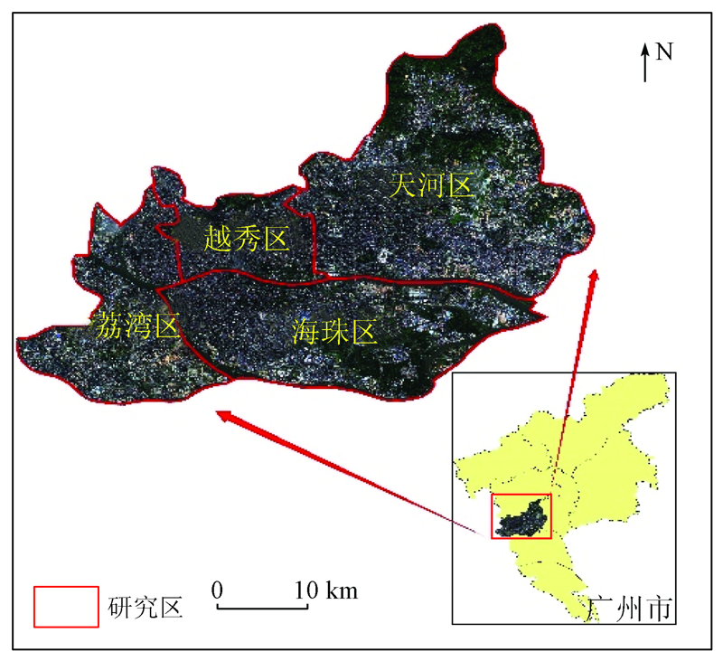
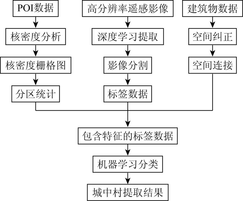
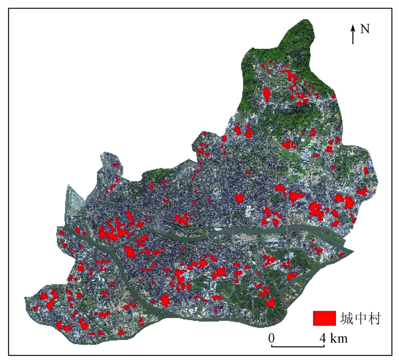
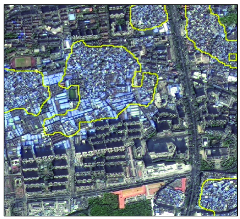
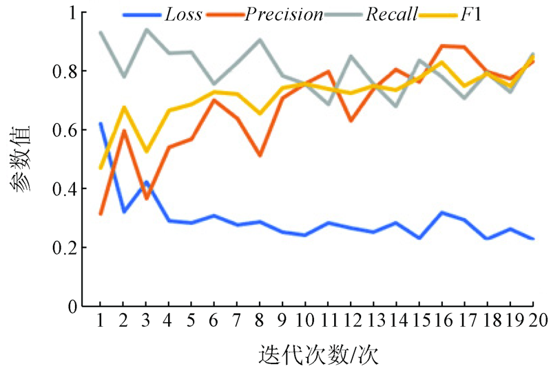
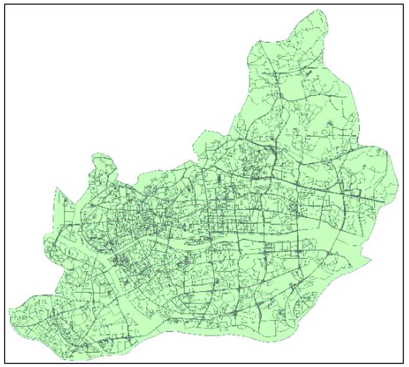
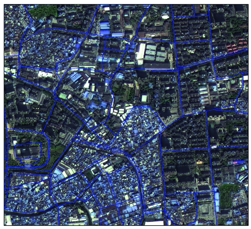
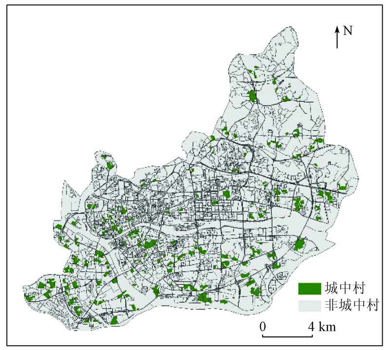
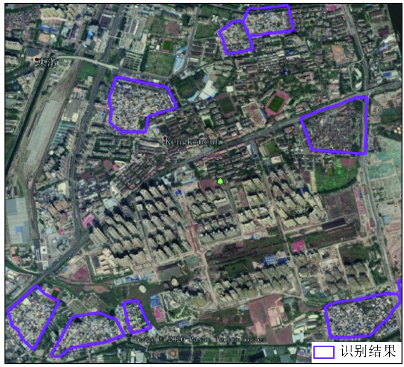
Abstract Urban villages refer to the rural settlements where the homesteads are surrounded by cities after the farmland in the settlements is expropriated. Given the lack of data support and quantitative analyses in the current researches on urban villages, this study aims to extract the boundaries of urban villages using the deep learning tools in ENVI based on multiple spatial data such as high-resolution remote sensing images, building outlines, and points of interest (POI). The study area is the main urban area of Guangzhou City-the capital of Guangdong Province, for which the initial correct recognition rate of urban villages was 64.31%. To overcome the confusion between the urban villages and some old residential areas and industrial areas in the extraction results, high-resolution remote sensing images were further segmented using the road network to produce label data of urban villages. Then the outlines of the urban villages in the city were extracted using a support vector machine classifier based on machine learning classification algorithms, obtaining precision of up to 90.19%. Therefore, this study can serve as a reference for the reconstruction of urban villages and urban planning and design in the study area to some extent.
|
| Keywords
urban villages
road network-based segmentation
label raster
deep learning
support vector machine
|
|
|
|
Corresponding Authors:
ZHANG Zhihua
E-mail: 916678730@qq.com;43447077@qq.com
|
|
Issue Date: 24 September 2021
|
|
|
| [1] |
刘辉. 基于高分辨率遥感影像的城中村提取方法研究[D]. 武汉:武汉大学, 2018.
|
| [1] |
Liu H. Study on extraction method of urban villages based on high-resolution remote sensing image[D]. Wuhan:Wuhan University, 2018.
|
| [2] |
Boutell M R, Luo J, Brown C M. Scene parsing using region-based generative models[J]. IEEE Transactions on Multimedia, 2007, 9(1):136-146.
doi: 10.1109/TMM.2006.886372
url: http://ieeexplore.ieee.org/document/4032602/
|
| [3] |
尚春艳. 基于高分辨率影像的城中村土地利用变化检测[D]. 西安:长安大学, 2017.
|
| [3] |
Shang C Y. Detection of land use change in urban villages based on high resolution images:A case study of Chang’an District,Xi’an City[D]. Xi’an:Chang’an University, 2017.
|
| [4] |
Li Y, Huang X, Liu H. Unsupervised deep feature learning for urban village detection from high-resolution remote sensing images[J]. Photogrammetric Engineering & Remote Sensing Journal of the American Society of Photogrammetry, 2017, 8(13):567-579.
|
| [5] |
Chen Y B, Chang K T, Han F Z, et al. Investigating urbanization and its spatial determinants in the central districts of Guangzhou,China[J]. Habitat International, 2016, 51:59-69.
doi: 10.1016/j.habitatint.2015.10.013
url: https://linkinghub.elsevier.com/retrieve/pii/S0197397515002192
|
| [6] |
周志华. 机器学习[M]. 北京: 清华大学出版社, 2016.
|
| [6] |
Zhou Z H. Machine learning[M]. Beijing: Tsinghua University Press, 2016.
|
| [7] |
崔珂玮, 张亚豪, 刘彤, 等. 基于ENVI深度学习模型的卫星影像识别方法研究[J]. 现代信息科技, 2020, 4(1):57-59.
|
| [7] |
Cui K W, Zhang Y H, Liu T, et al. Research on satellite image recognition method based on ENVI deep learning model[J]. Modern Information Technology, 2020, 4(1):57-59.
|
| [8] |
黄亮, 左小清, 冯冲, 等. 基于Canny算法的面向对象影像分割[J]. 国土资源遥感, 2011, 23(4):26-30.doi: 10.6046/gtzyyg.2011.04.05.
doi: 10.6046/gtzyyg.2011.04.05
|
| [8] |
Huang L, Zuo X Q, Feng C, et al. Object-oriented image segmentation based on Canny algorithm[J]. Remote Sensing for Land and Resources, 2011, 23(4):26-30.doi: 10.6046/gtzyyg.2011.04.05.
doi: 10.6046/gtzyyg.2011.04.05
|
| [9] |
高扬. 基于卷积神经网络的高分辨率遥感影像建筑物提取[D]. 南京:南京大学, 2018.
|
| [9] |
Gao Y. Building extraction of high-resolution remote sensing image based on convolutional neural network[D]. Nanjing:Nanjing University, 2018.
|
| [10] |
Cui C H, Han Z G. Spatial patterns of retail stores using POIs data in Zhengzhou,China[C]// 2015 2nd IEEE International Conference on Spatial Data Mining and Geographical Knowledge Services(ICSDM).IEEE, 2015:88-92.
|
| [11] |
Liu J, Deng Y, Wang Y, et al. Urban nighttime leisure space mapping with nighttime light images and POI data[J]. Remote Sensing, 2020, 12(3):541.
doi: 10.3390/rs12030541
url: https://www.mdpi.com/2072-4292/12/3/541
|
| [12] |
禹文豪, 艾廷华. 核密度估计法支持下的网络空间POI点可视化与分析[J]. 测绘学报, 2015(1):82-90.
|
| [12] |
Yu W H, Ai T H. The visualization and analysis of POI features under network space supported by kernel density estimation[J]. Journal of Surveying and Mapping, 2015(1):82-90.
|
| [13] |
Maulik U, Chakraborty D. Remote sensing image classification:A survey of support-vector-machine-based advanced techniques[J]. IEEE Geoscience and Remote Sensing Magazine, 2017, 5(1):33-52.
doi: 10.1109/MGRS.2016.2641240
url: http://ieeexplore.ieee.org/document/7882747/
|
| [14] |
Patra S, Bruzzone L. A novel SOM-SVM-based active learning technique for remote sensing image classification[J]. IEEE Transactions on Geoscience and Remote Sensing, 2014, 52(11):6899-6910.
doi: 10.1109/TGRS.2014.2305516
url: http://ieeexplore.ieee.org/document/6754133/
|
| [15] |
陈昂, 杨秀春, 徐斌, 等. 基于面向对象与深度学习的榆树疏林识别方法研究[J]. 地球信息科学学报, 2020, 22(9):1897-1909.
doi: 10.12082/dqxxkx.2019.190598
|
| [15] |
Chen A, Yang X C, Xu B, et al. Study on drought and flood evolution in Guangxi based on TRMM data and SPI drought index[J]. Journal of Geo-Information Science, 2020, 22(9):1897-1909.
|
| [16] |
陈良浩, 朱彩英, 郭连惠, 等. 基于DSM点云纠正的正射影像房屋边缘锯齿消除[J]. 测绘科学技术学报, 2017, 34(3):279-282.
|
| [16] |
Chen L H, Zhu C Y, Guo L H, et al. Removing aliasing effects of house edge in DOM based on the correction of DSM[J]. Journal of Geomatics Science and Technology, 2017, 34(3):279-282.
|
| [17] |
刘文雅, 岳安志, 季珏, 等. 基于DeepLabv3+语义分割模型的GF-2影像城市绿地提取[J]. 国土资源遥感, 2020, 32(2):120-129.doi: 10.6046/gtzyyg.2020.02.16.
doi: 10.6046/gtzyyg.2020.02.16
|
| [17] |
Liu W Y, Yue A Z, Ji J, et al. Urban green space extraction from GF-2 remote sensing image based on DeepLabv3+semantic segmentation model[J]. Remote Sensing for Land and Resources, 2020, 32(2):120-129.doi: 10.6046/gtzyyg.2020.02.16.
doi: 10.6046/gtzyyg.2020.02.16
|
| [18] |
罗仙仙, 曾蔚, 陈小瑜, 等. 深度学习方法用于遥感图像处理的研究进展[J]. 泉州师范学院学报, 2017, 35(6):35-41.
|
| [18] |
Luo X X, Zeng W, Chen X Y, et al. Research progress of deep learning method used to remote sensing image processing[J]. Journal of Quanzhou Normal University, 2017, 35(6):35-41.
|
| [19] |
Tastan E, Sozen T. Oblique split technique in septal reconstruction[J]. Facial Plastic Surgery, 2013, 29(6):487-491.
doi: 10.1055/s-0033-1360599
pmid: 24327247
|
| [20] |
Abdiansah A, Wardoyo R. Time complexity analysis of support vector machines(SVM) in LIBSVM[J]. International Journal Computer and Application, 2015, 128(3):28-34.
|
| [21] |
刘伟. 基于无人机多光谱遥感影像的地物分类方法研究[D]. 石河子:石河子大学, 2017.
|
| [21] |
Liu W. Study of object classification based on multispectral images of UAV[D]. Shihezi:Shihezi University, 2017.
|
| [22] |
胡蕾, 侯鹏洋. 一种基于光谱与纹理特征的多光谱遥感图像地物分类方法[J]. 中国科技论文, 2015, 10(2):197-200.
|
| [22] |
Hu L, Hou P Y. A multi-spectral remote sensing image feature classification method based on spectrum and texture features[J]. Chinese Science and Technology Paper, 2015, 10(2):197-200.
|
|
Viewed |
|
|
|
Full text
|
|
|
|
|
Abstract
|
|
|
|
|
Cited |
|
|
|
|
| |
Shared |
|
|
|
|
| |
Discussed |
|
|
|
|
 2021,
Vol. 33
2021,
Vol. 33