|
|
 |
|

|
|
|
Lake water storage estimation method based on topographic parameters: A case study of Nam Co Lake |
Xiaoqi MA1,2, Shanlong LU1( ), Jin MA3, Liping ZHU4 ), Jin MA3, Liping ZHU4 |
1. Key Laboratory of Digital Earth Institute, State Key Laboratory of Remote Sensing Science, Institute of Remote Sensing and Digital Earth, Chinese Academy of Sciences, Beijing 100101, China
2. School of Earth Sciences and Resources, China University of Geosciences, Beijing 100083, China
3. College of Information Science and Engineering, Shandong Agricultural University, Taian 271018, China
4. Institute of Tibetan Plateau Research, Chinese Academy of Sciences, Beijing 100101, China |
|
|
|
|
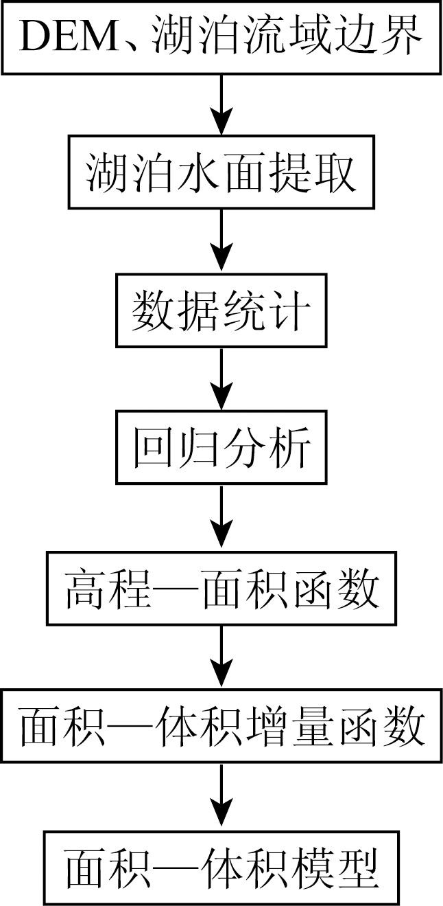
Abstract Lake water reserves are often estimated according to water level observation and manually-measured underwater topography data. As for the lakes which lack data, it is really difficult to obtain the information of lake water reserves. In order to explore the solution of this problem, the authors chose the Nam Co Lake in Tibet as a study case. Based on the features of topography similarities between the above lake level and the under lake level, the authors made use of SRTM DEM of above the lake level to construct the relationship between the elevation and the area, the area and the volume increment. In turn, the elevation-area-volume increment of the lake's underwater was recalculated. Finally, the authors constructed the area-volume model to calculate the lake water reserves. The result shows that the calculation is of high relative accuracy. According to the area of the lake by using the DEM of the Nam Co Lake basin,the authors calculated the lake water reserves, which reach 111.570 billion m 3. This result is compared with the calculated water reserves of 101.950 billion m 3 in the Nam Co Lake underwater terrain digital elevation model established based on measured water depth data, and its absolute error is 9.620 billion m 3 whereas its relative error is 9.40%. The results obtained by the authors provide a reference for the estimation of natural lake water reserves with consistent water and underwater topographic parameters in data-absent areas.
|
| Keywords
DEM
water reserves
no data area
lakes
Nam Co Lake
|
|
|
|
Corresponding Authors:
Shanlong LU
E-mail: lusl@radi.ac.cn
|
|
Issue Date: 03 December 2019
|
|
|
| [1] |
Medina C, Gomez-Enri J, Alonso J J , et al. Water volume variations in Lake Izabal (Guatemala) from in situ measurements and ENVISAT Radar altimeter (RA-2) and advanced synthetic aperture Radar (ASAR) data products[J]. Journal of Hydrology, 2010,382(1-4):34-48.
|
| [2] |
Brooks R T, Hayashi M . Depth-area-volume and hydroperiod relationships of ephemeral (vernal) forest pools in southern New England[J]. Wetlands, 2002,22(2):247-255.
|
| [3] |
Gleason R A, Tangen B A, Laubhan M K , et al. Estimating Water Storage Capacity of Existing and Potentially Restorable Wetland Depressions in a Subbasin of the Red River of the North[R]. USGS Northern Prairie Wildlife Research Center, 2007.
|
| [4] |
Lane C R, D’Amico E .Calculating the ecosystem service of water storage in isolated wetlands using LiDAR in north central Florida,USA[J]. Wetlands, 2010,30(5):967-977.
|
| [5] |
Zhang B, Wu Y, Zhu L , et al. Estimation and trend detection of water storage at Nam Co Lake,central Tibetan Plateau[J]. Journal of Hydrology, 2011,405(1-2):161-170.
|
| [6] |
Heathcote A J, del Giorgio P A, Prairie Y T . Predicting bathymetric features of lakes from the topography of their surrounding landscape[J]. Canadian journal of fisheries and aquatic sciences, 2015,72(5):643-650.
|
| [7] |
Sobek S, Nisell J, Fölster J . Predicting the depth and volume of lakes from map-derived parameters[J]. Inland Waters, 2011,1(3):177-184.
|
| [8] |
Messager M L, Lehner B, Grill G , et al. Estimating the volume and age of water stored in global lakes using a geo-statistical approach[J]. Nature communications, 2016,7:13603.
|
| [9] |
Liao J, Shen G, Li Y . Lake variations in response to climate change in the Tibetan Plateau in the past 40 years[J]. International Journal of Digital Earth, 2013,6(6):534-549.
|
| [10] |
Yang R, Zhu L, Wang J , et al. Spatiotemporal variations in volume of closed lakes on the Tibetan Plateau and their climatic responses from 1976 to 2013[J]. Climatic Change, 2017,140(3-4):621-633.
|
| [11] |
朱立平, 乔宝晋, 杨瑞敏 , 等. 青藏高原湖泊水量与水质变化的新认知[J]. 自然杂志, 2017,39(3):166-172.
|
| [11] |
Zhu L P, Qiao B J, Yang R M , et al. A new cognition of the variation of water and water quality in the Qinghai-Tibet Plateau[J]. Chinese Journal of Nature, 2017,39(3):166-172.
|
| [12] |
Qiao B, Zhu L, Wang J , et al. Estimation of lakes water storage and their changes on the northwestern Tibetan Plateau based on bathymetric and Landsat data and driving force analyses[J]. Quaternary International, 2017,454:56-67.
|
| [13] |
Song C, Huang B, Ke L . Modeling and analysis of lake water storage changes on the Tibetan Plateau using multi-mission satellite data[J]. Remote Sensing of Environment, 2013,135:25-35.
|
| [14] |
关志华, 陈传友, 区裕雄 , 等. 西藏河流与湖泊[M]. 北京: 科学出版社, 1984.
|
| [14] |
Guan Z H, Chen C Y, Ou Y X , et al. Rivers and Lakes in Tibet[M]. Beijing: Science and Technology Press, 1984.
|
| [15] |
卢善龙, 肖高怀, 贾立 , 等. 2000—2012年青藏高原湖泊水面时空过程数据集遥感提取[J]. 国土资源遥感, 2016,28(3):181-187.doi: 10.6046/gtzyyg.2016.03.28.
doi: 10.6046/gtzyyg.2016.03.28
|
| [15] |
Lu S L, Xiao G H, Jia L , et al. Extraction of the spatial-temporal lake water surface dataset in the Tibetan Plateau over the past 10 years[J]. Remote Sensing for Land and Resources, 2016,28(3):181-187.doi: 10.6046/gtzyyg.2016.03.28.
|
| [16] |
Wang J B, Zhu L P, Daut G , et al. Investigation of bathymetry and water quality of Lake Nam Co,the largest lake on the central Tibetan Plateau,China[J]. Limnology, 2009,10(2):149-158.
|
| [17] |
Rabus B, Eineder M, Roth A , et al. The shuttle Radar topography mission:A new class of digital elevation models acquired by spaceborne Radar[J]. ISPRS Journal of Photogrammetry and Remote Sensing, 2003,57(4):241-262.
|
| [18] |
van Zyl J J . The shuttle Radar topography mission (SRTM):A breakthrough in remote sensing of topography[J]. Acta Astronautica, 2001,48(5-12):559-565.
|
| [19] |
Slater J A, Garvey G, Johnston C , et al. The SRTM data “finishing” process and products[J]. Photogrammetric Engineering and Remote Sensing, 2006,72(3):237-247.
|
| [20] |
李炳元 . 青藏高原大湖期[J].地理学报,2000(2):174-182.
|
| [20] |
Li B Y . The great lake period of the Qinghai-Tibet Plateau[J].Acta Geographica Sinica,2000(2):174-182.
|
| [21] |
蒋瑛 . 基于RS和GIS的青藏高原高湖面与现在湖面对比研究[D]. 西宁:青海师范大学, 2013.
|
| [21] |
Jiang Y . Using RS and GIS Research of Comparison Between the Ancient Lake Level and the Lake Level Nowadays on Qinghai-Tibet Plateau[D]. Xining:Qinghai Normal University, 2013.
|
| [22] |
马荣华, 杨桂山, 段洪涛 , 等. 中国湖泊的数量,面积与空间分布[J]. 中国科学(地球科学), 2011,41(3):394-401.
|
| [22] |
Ma R H, Yang G S, Duan H T , et al. China’ s lakes at present:Number,area and spatial distribution[J]. Science China Earth Sciences, 2011,41(3):394-401.
|
|
Viewed |
|
|
|
Full text
|
|
|
|
|
Abstract
|
|
|
|
|
Cited |
|
|
|
|
| |
Shared |
|
|
|
|
| |
Discussed |
|
|
|
|
 2019,
Vol. 31
2019,
Vol. 31