|
|
 |
|

|
|
|
An improved spatio-temporal fusion model for remote sensing images based on singular spectrum analysis |
AN Na1( ), ZHAO Yingying2, SUN Yaqin1, ZHANG Aizhu3, FU Hang3, YAO Yanjuan4(), SUN Genyun3,5 ), ZHAO Yingying2, SUN Yaqin1, ZHANG Aizhu3, FU Hang3, YAO Yanjuan4(), SUN Genyun3,5 |
1. China Aero Geophysical Survey and Remote Sensing Center for Natural Resources, Beijing 100083, China
2. Changsha Planning and Design Survey Research Institute, Changsha 410007, China
3. College of Oceanography and Space Informatics, China University of Petroleum (East China), Qingdao 266580, China
4. Satellite Environment Center, Ministry of Environmental protection of China, Beijing 100094, China
5. Laboratory for Marine Resources Qingdao National Laboratory for Marine Science and Technology, Qingdao 266237, China |
|
|
|
|
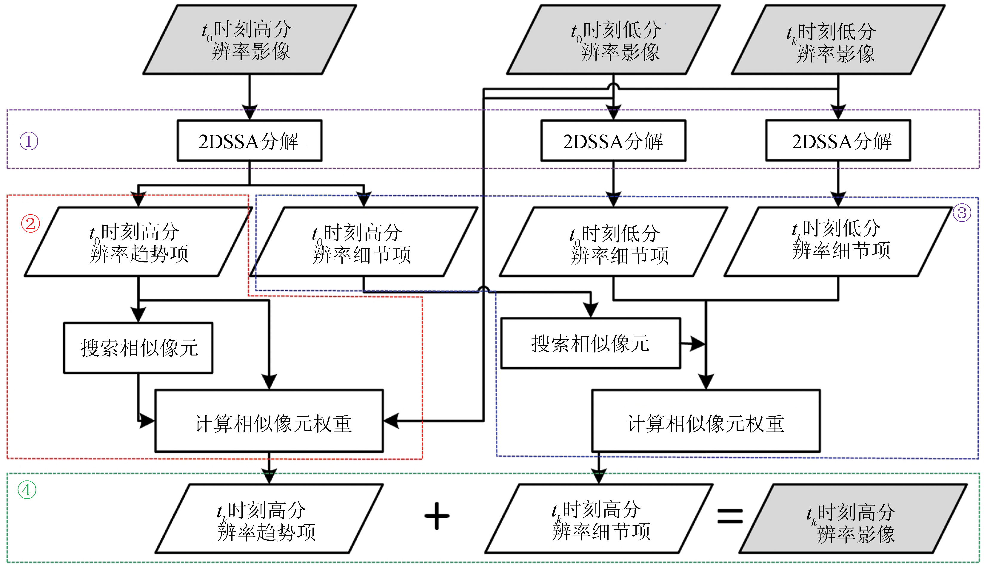
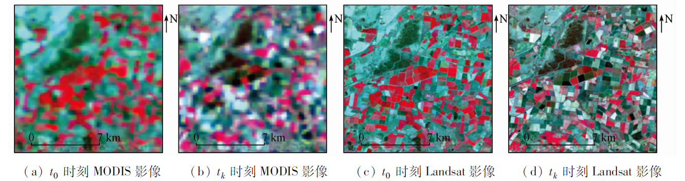
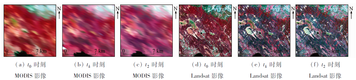
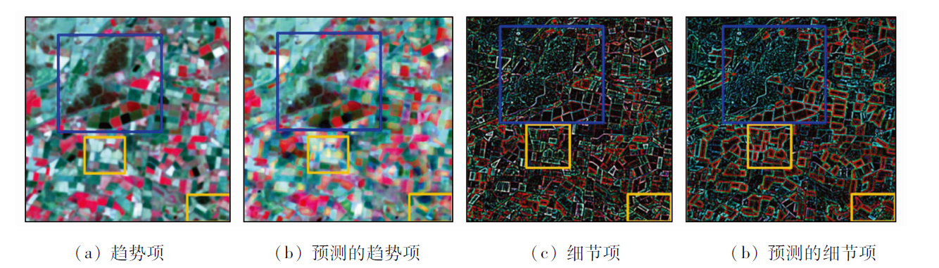
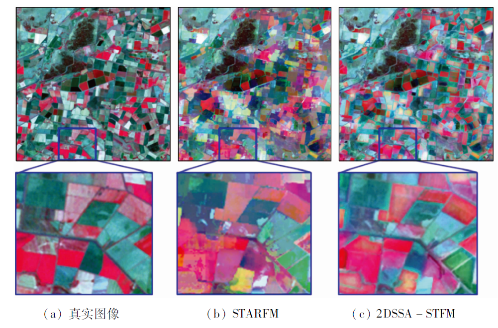
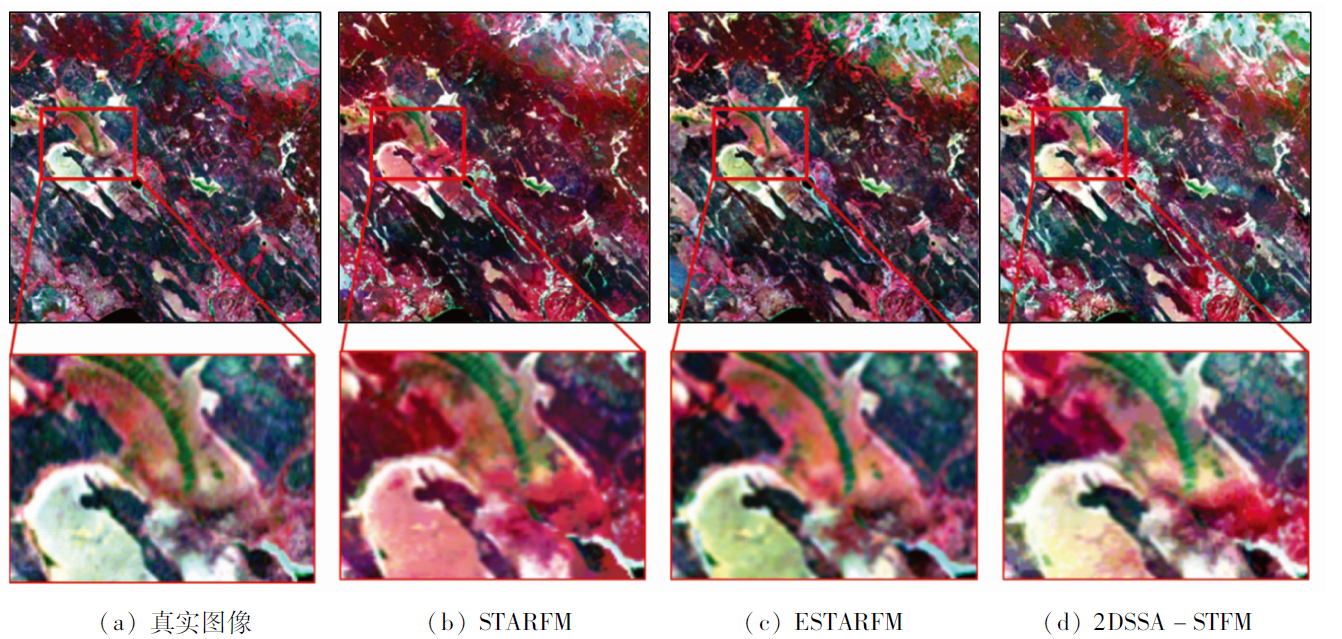
Abstract Spatio-temporal fusion can generate image sequences with sufficiently high temporal and spatial resolution. However, current studies tend to improve prediction accuracy using as much spatio-temporal data as possible and complex non-linear models, while few of them focus on analyzing images themselves by making full use of their intrinsic features, such as trends and textures. This study proposed a 2DSSA spatio-temporal fusion model (2DSSA-STFM) based on 2D singular spectrum analysis (2DSSA). In this model, the major spatial trends and details of the existing images at the target moment can be predicted by decomposing the images into trend and detail components. Firstly, the linear relationship between the trend of high-spatial-resolution data and low-spatial-resolution data was built to calculate the trend components of the images at the target moment. Then, the linear relationship between the low-resolution and the high-resolution detail components in two time phases was established to determine the detail components of the images at the target moment. Finally, the calculated trend and detail components were combined to form the target prediction images. The 2DSSA-STFM was applied to two sets of medium-resolution Landsat7 ETM+ and MODIS images, yielding smaller experimental errors than conventional spatio-temporal fusion models.
|
| Keywords
spatio-temporal fusion
singular spectrum analysis
trend component
detail component
decomposition
|
|
|
|
Issue Date: 07 July 2023
|
|
|
| [1] |
Roy D P, Wulder M A, Loveland T R, et al. Landsat8:Science and product vision for terrestrial global change research[J]. Remote Sensing of Environment, 2014, 145:154-172.
doi: 10.1016/j.rse.2014.02.001
url: https://linkinghub.elsevier.com/retrieve/pii/S003442571400042X
|
| [2] |
Singh D. Generation and evaluation of gross primary productivity using Landsat data through blending with MODIS data[J]. International Journal of Applied Earth Observation and Geoinformation, 2011, 13(1):59-69.
doi: 10.1016/j.jag.2010.06.007
url: https://linkinghub.elsevier.com/retrieve/pii/S0303243410000711
|
| [3] |
Bhandari S, Phinn S, Gill T. Preparing Landsat image time series (LITS) for monitoring changes in vegetation phenology in Queensland,Australia[J]. Remote Sensing, 2012, 4(6):1856-1886.
doi: 10.3390/rs4061856
url: http://www.mdpi.com/2072-4292/4/6/1856
|
| [4] |
Weng Q H, Fu P, Gao F. Generating daily land surface temperature at Landsat resolution by fusing Landsat and MODIS data[J]. Remote Sensing of Environment, 2014, 145:55-67.
doi: 10.1016/j.rse.2014.02.003
url: https://linkinghub.elsevier.com/retrieve/pii/S0034425714000479
|
| [5] |
Gevaert C M, García-Haro F J. A comparison of STARFM and an unmixing-based algorithm for Landsat and MODIS data fusion[J]. Remote Sensing of Environment, 2015, 156:34-44.
doi: 10.1016/j.rse.2014.09.012
url: https://linkinghub.elsevier.com/retrieve/pii/S0034425714003551
|
| [6] |
邬明权, 牛铮, 王长耀. 多源遥感数据时空融合模型应用分析[J]. 地球信息科学学报, 2014, 16(5):776-783.
doi: 10.3724/SP.J.1047.2014.00776
|
| [6] |
Wu M Q, Niu Z, Wang C Y. Assessing the accuracy of spatial and temporal image fusion model of complex area in south China[J]. Journal of Geo-Information Science, 2014, 16(5):776-783.
|
| [7] |
Zhao Y, Huang B, Song H. A robust adaptive spatial and temporal image fusion model for complex land surface changes[J]. Remote Sensing of Environment, 2018, 208:42-62.
doi: 10.1016/j.rse.2018.02.009
url: https://linkinghub.elsevier.com/retrieve/pii/S0034425718300154
|
| [8] |
张爱竹, 王伟, 郑雄伟, 等. 一种基于分层策略的时空融合模型[J]. 自然资源遥感, 2021, 33(3):18-26.doi:10.6046/zrzyyg.2020346.
doi: 10.6046/zrzyyg.2020346
|
| [8] |
Zhang A Z, Wang W, Zheng X W, et al. A hierarchical spatial-temporal fusion model[J]. Remote Sensing for Natural Resources, 2021, 33(3):18-26.doi:10.6046/zrzyyg.2020346.
doi: 10.6046/zrzyyg.2020346
|
| [9] |
Wu M, Wu C, Huang W, et al. An improved high spatial and temporal data fusion approach for combining Landsat and MODIS data to generate daily synthetic Landsat imagery[J]. Information Fusion, 2016, 31:14-25.
doi: 10.1016/j.inffus.2015.12.005
url: https://linkinghub.elsevier.com/retrieve/pii/S1566253515001177
|
| [10] |
Huang B, Song H. Spatiotemporal reflectance fusion via sparse representation[J]. IEEE Transactions on Geoscience and Remote Sensing, 2012, 50(10):3707-3716.
doi: 10.1109/TGRS.2012.2186638
url: http://ieeexplore.ieee.org/document/6169983/
|
| [11] |
Cheng Q, Liu H, Shen H, et al. A spatial and temporal nonlocal filter-based data fusion method[J]. IEEE Transactions on Geoscience and Remote Sensing, 2017, 55(8):4476-4488.
doi: 10.1109/TGRS.2017.2692802
url: http://ieeexplore.ieee.org/document/7917259/
|
| [12] |
Li J, Li Y, He L, et al. Spatio-temporal fusion for remote sensing data:An overview and new benchmark[J]. Science China Information Sciences, 2020, 63(4):7-23.
|
| [13] |
董文全, 蒙继华. 遥感数据时空融合研究进展及展望[J]. 国土资源遥感, 2018, 30(2):1-11.doi:10.6046/gtzyyg.2018.02.01.
doi: 10.6046/gtzyyg.2018.02.01
|
| [13] |
Dong W Q, Meng J H. Review of spatiotemporal fusion model of remote sensing data[J]. Remote Sensing for Land and Resources, 2018, 30(2):1-11.doi:10.6046/gtzyyg.2018.02.01.
doi: 10.6046/gtzyyg.2018.02.01
|
| [14] |
Gao F, Masek J, Schwaller M, et al. On the blending of the Landsat and MODIS surface reflectance:Predicting daily Landsat surface reflectance[J]. IEEE Transactions on Geoscience and Remote Sensing, 2006, 44(8):2207-2218.
doi: 10.1109/TGRS.2006.872081
url: http://ieeexplore.ieee.org/document/1661809/
|
| [15] |
Zhu X, Chen J, Gao F, et al. An enhanced spatial and temporal adaptive reflectance fusion model for complex heterogeneous regions[J]. Remote Sensing of Environment, 2010, 114(11):2610-2623.
doi: 10.1016/j.rse.2010.05.032
url: https://linkinghub.elsevier.com/retrieve/pii/S0034425710001884
|
| [16] |
Shao Z, Cai J, Fu P, et al. Deep learning-based fusion of Landsat8 and Sentinel-2 images for a harmonized surface reflectance product[J]. Remote Sensing of Environment, 2019, 235(12):111425.
doi: 10.1016/j.rse.2019.111425
url: https://linkinghub.elsevier.com/retrieve/pii/S0034425719304444
|
| [17] |
Li Y, Li J, He L, et al. A new sensor bias-driven spatio-temporal fusion model based on convolutional neural networks[J]. Science China Information Sciences, 2020, 63(4):20-35.
|
| [18] |
Jia D, Song C, Cheng C, et al. A novel deep learning-based spatio-temporal fusion method for combining satellite images with different resolutions using a two-stream convolutional neural network[J]. Remote Sensing, 2020, 12(4):698.
doi: 10.3390/rs12040698
url: https://www.mdpi.com/2072-4292/12/4/698
|
| [19] |
Fu H, Sun G, Ren J, et al. Fusion of PCA and segmented-PCA domain multiscale 2-D-SSA for effective spectral-spatial feature extraction and data classification in hyperspectral imagery[J]. IEEE Transactions on Geoscience and Remote Sensing, 2022, 60:1-14.
|
| [20] |
Sun G, Fu H, Ren J, et al. SpaSSA:Superpixelwise adaptive SSA for unsupervised spatial-spectral feature extraction in hyperspectral image[J]. IEEE Transactions on Cybernetics, 2022, 52(7):6158-6169.
doi: 10.1109/TCYB.2021.3104100
url: https://ieeexplore.ieee.org/document/9533174/
|
| [21] |
Zabalza J, Ren J, Zheng J, et al. Novel two-dimensional singular spectrum analysis for effective feature extraction and data classification in hyperspectral imaging[J]. IEEE Transactions on Geoscience and Remote Sensing, 2015, 53(8):4418-4433.
doi: 10.1109/TGRS.36
url: https://ieeexplore.ieee.org/xpl/RecentIssue.jsp?punumber=36
|
| [22] |
Emelyanova I V, McVicar T R, Van Niel T G, et al. Assessing the accuracy of blending Landsat-MODIS surface reflectances in two landscapes with contrasting spatial and temporal dynamics:A framework for algorithm selection[J]. Remote Sensing of Environment, 2013, 133:193-209.
doi: 10.1016/j.rse.2013.02.007
url: https://linkinghub.elsevier.com/retrieve/pii/S0034425713000473
|
| [23] |
刘慧琴, 吴鹏海, 沈焕锋, 等. 一种基于非局部滤波的遥感时空信息融合方法[J]. 地理与地理信息科学. 2015, 31(4):27-32.
|
| [23] |
Liu H W, Wu P H, Sheng H F. A spatio-temporal information fusion method based on non-local means filter[J]. Geography and Geo-Information Science, 2015, 31(4):27-32.
|
|
Viewed |
|
|
|
Full text
|
|
|
|
|
Abstract
|
|
|
|
|
Cited |
|
|
|
|
| |
Shared |
|
|
|
|
| |
Discussed |
|
|
|
|
 2023,
Vol. 35
2023,
Vol. 35