|
|
 |
|

|
|
|
Remote sensing monitoring of the spatio-temporal changes in pond aquaculture based on mixed pixel decomposition |
SHENG Dezhi1,2,3( ), XING Qianguo1,2,3(), LIU Hailong1,2,3, ZHENG Xiangyang1,2,3 ), XING Qianguo1,2,3(), LIU Hailong1,2,3, ZHENG Xiangyang1,2,3 |
1. Key Laboratory of Coastal Environmental Processes and Ecological Remediation, Yantai Institute of Coastal Zone Research, Chinese Academy of Sciences, Yantai 264003, China
2. Shandong Key Laboratory of Coastal Environmental Processes, Yantai 264003, China
3. University of Chinese Academy of Sciences, Beijing 100049, China |
|
|
|
|
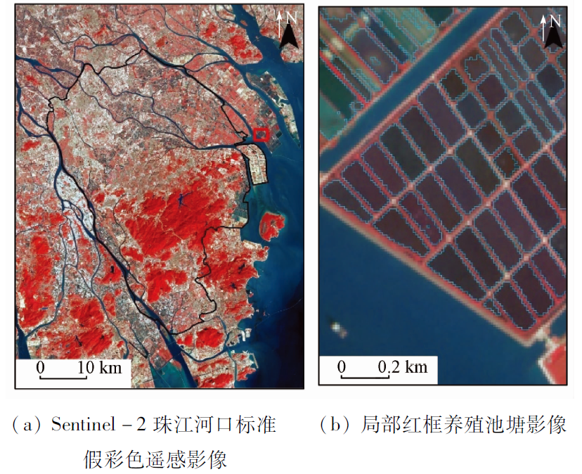
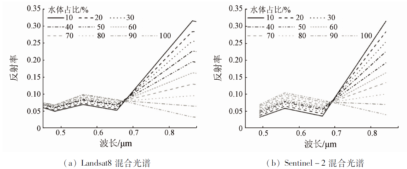
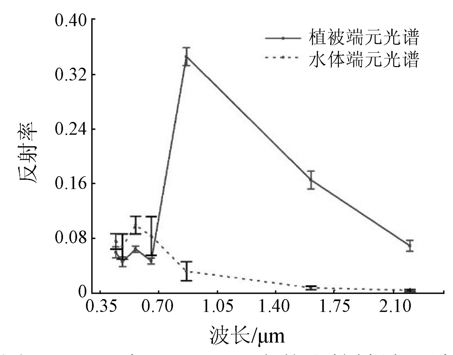
Abstract Aquaculture is an important way for humans to obtain food, and aquaculture ponds are a major production mode of aquaculture. The Pearl River Delta, as an important aquaculture base in southern China, has undergone great changes in its spatial distribution in the past 30 years. This study investigated Zhongshan City and its adjacent areas. First, the mixed pixels of Landsat and Sentinel-2 remote sensing data were decomposed using the linear mixed pixel decomposition method. Then, the NDWI threshold range corresponding to the water abundance of 70% and above was selected through visual comparison and analysis. Finally, the spatio-temporal distribution of typical aquaculture ponds from 1990 to 2021 was obtained. The study results show that the aquaculture ponds in Zhongshan City and its adjacent areas have experienced a process of first increasing and then decreasing since 1990. Specifically, the area of aquaculture ponds nearly doubled from 1990 to 2000, tended to be stable from 2000 to 2010, but decreased by nearly 50% from 2010 to 2021. This study can reduce the impact of mixed pixels on the monitoring of aquaculture ponds and support the scientific aquaculture and sustainable development of fisheries in the Greater Bay Area.
|
| Keywords
NDWI
mixed pixel decomposition
aquaculture pond
Zhongshan City
Pearl River Delta
|
|
|
|
Issue Date: 27 December 2022
|
|
|
| [1] |
FAO. The state of world fisheries and aquaculture (SOFIA)[R]. Rome: Food and Agriculture Organization of the United Nations, 2020.
|
| [2] |
于秀娟, 徐乐俊, 吴反修, 等. 中国渔业统计年鉴[M]. 北京: 中国农业出版社, 2020:1-66.
|
| [2] |
Yu X J, Xu L J, Wu F X, et al. China fishery statistical yearbook[M]. Beijing: China Agricultural Press, 2020:1-66.
|
| [3] |
Ren C, Wang Z, Zhang Y, et al. Rapid expansion of coastal aquaculture ponds in China from Landsat observations during 1984—2016[J]. International Journal of Applied Earth Observation and Geoinformation, 2019, 82:101902.
doi: 10.1016/j.jag.2019.101902
url: https://linkinghub.elsevier.com/retrieve/pii/S0303243419304295
|
| [4] |
Orimoloye I R, Kalumba A M, Mazinyo S P, et al. Geospatial analysis of wetland dynamics:Wetland depletion and biodiversity conservation of Isimangaliso Wetland,South Africa[J]. Journal of King Saud University-Science, 2020, 32(1):90-96.
doi: 10.1016/j.jksus.2018.03.004
url: https://linkinghub.elsevier.com/retrieve/pii/S1018364718302301
|
| [5] |
Hu W, Li G, Li Z. Spatial and temporal evolution characteristics of the water conservation function and its driving factors in regional lake wetlands:Two types of homogeneous lakes as examples[J]. Ecological Indicators, 2021, 130:108069.
doi: 10.1016/j.ecolind.2021.108069
url: https://linkinghub.elsevier.com/retrieve/pii/S1470160X21007342
|
| [6] |
Gallant K, Withey P, Risk D, et al. Measurement and economic valuation of carbon sequestration in Nova Scotian wetlands[J]. Ecological Economics, 2020, 171:106619.
doi: 10.1016/j.ecolecon.2020.106619
url: https://linkinghub.elsevier.com/retrieve/pii/S092180091931362X
|
| [7] |
Liu X, Wang Y, Costanza R, et al. The value of China’s coastal wetlands and seawalls for storm protection[J]. Ecosystem Services, 2019, 36:100905.
doi: 10.1016/j.ecoser.2019.100905
url: https://linkinghub.elsevier.com/retrieve/pii/S2212041618305886
|
| [8] |
丁疆华, 温琰茂. 基塘系统中水产养殖对环境的影响[J]. 资源生态环境网络研究动态, 2001, 12(1):29-33.
|
| [8] |
Ding J H, Wen Y M. The effect of aquaculture in the dike-pond ecosystem on environment[J]. Research Trend of Resource Ecological Environment Network, 2001, 12(1):29-33.
|
| [9] |
Ma J, Niu X, Zhang D, et al. High levels of microplastic pollution in aquaculture water of fish ponds in the Pearl River Estuary of Guangzhou,China[J]. Science of the Total Environment, 2020, 744:140679.
doi: 10.1016/j.scitotenv.2020.140679
url: https://linkinghub.elsevier.com/retrieve/pii/S0048969720342017
|
| [10] |
程田飞, 周为峰, 樊伟. 水产养殖区域的遥感识别方法进展[J]. 国土资源遥感, 2012, 24(3):1-5.doi:10.6046 /gtzyyg.2012.03.01.
doi: 10.6046 /gtzyyg.2012.03.01
|
| [10] |
Cheng T F, Zhou W F, Fan W. Progress in the methods for extracting aquaculture areas from remote sensing data[J]. Remote Science for Land and Resources, 2012, 24(3):1-5.doi:10.6046 /gtzyyg.2012.03.01.
doi: 10.6046 /gtzyyg.2012.03.01
|
| [11] |
Pattanaik C, Prasad S N. Assessment of aquaculture impact on mangroves of Mahanadi delta (Orissa),east coast of India using remote sensing and GIS[J]. Ocean and Coastal Management, 2011, 54(11):789-795.
doi: 10.1016/j.ocecoaman.2011.07.013
url: https://linkinghub.elsevier.com/retrieve/pii/S096456911100113X
|
| [12] |
姚云长, 任春颖, 王宗明, 等. 1985 年和 2010 年中国沿海盐田和养殖池遥感监测[J]. 湿地科学, 2016, 14(6):874-882.
|
| [12] |
Yao Y C, Ren C Y, Wang Z M, et al. Monitoring of salt ponds and aquaculture ponds in the coastal zone of China in 1985 and 2010[J]. Wetland Science, 2016, 14(6):874-882.
|
| [13] |
徐涵秋. 利用改进的归一化差异水体指数(MNDWI)提取水体信息的研究[J]. 遥感学报, 2005, 9(5):589-595.
|
| [13] |
Xu H Q. A study on information extraction of water body with the modified normalized difference water index (MNDWI)[J]. Journal of Remote Sensing, 2005, 9(5):589-595.
|
| [14] |
裴亮, 王金鑫, 屈慧慧, 等. 基于ONDPI的海岸养殖池塘遥感影像提取研究[J]. 海洋测绘, 2020, 40(5):40-44.
|
| [14] |
Pei L, Wang J X, Qu H H, et al. Research on remote image extraction of coastal aquaculture pond based on ONDPI[J]. Hydrographic Surveying and Charting, 2020, 40(5):40-44.
|
| [15] |
Cheng B, Liang C, Liu X, et al. Research on a novel extraction method using deep learning based on GF-2 images for aquaculture areas[J]. International Journal of Remote Sensing, 2020, 41(9):3575-3591.
doi: 10.1080/01431161.2019.1706009
url: https://www.tandfonline.com/doi/full/10.1080/01431161.2019.1706009
|
| [16] |
Duan Y, Tian B, Li X, et al. Tracking changes in aquaculture ponds on the China coast using 30 years of Landsat images[J]. International Journal of Applied Earth Observation and Geoinformation, 2021, 102:102383.
doi: 10.1016/j.jag.2021.102383
url: https://linkinghub.elsevier.com/retrieve/pii/S0303243421000908
|
| [17] |
Ren C, Wang Z, Zhang B, et al. Remote monitoring of expansion of aquaculture ponds along coastal region of the Yellow River Delta from 1983 to 2015[J]. Chinese Geographical Science, 2018, 28(3):430-442.
doi: 10.1007/s11769-017-0926-2
url: https://doi.org/10.1007/s11769-017-0926-2
|
| [18] |
孙晓宇, 苏奋振, 周成虎, 等. 基于 RS 与 GIS 的珠江口养殖用地时空变化分析[J]. 资源科学, 2010, 32 (1):71-77.
|
| [18] |
Sun X Y, Su F Z, Zhou C H, et al. Analyses on spatial-temporal changes in aquaculture land in coastal areas of the Pearl River Estuarine[J]. Resources Science, 2010, 32 (1):71-77.
|
| [19] |
Chang Z Q, Neori A, He Y Y, et al. Development and current state of seawater shrimp farming,with an emphasis on integrated multi-trophic pond aquaculture farms,in China:A review[J]. Reviews in Aquaculture, 2020, 12(4):2544-2558.
doi: 10.1111/raq.12457
url: https://onlinelibrary.wiley.com/doi/10.1111/raq.12457
|
| [20] |
陈峰, 邱全毅, 熊永柱, 等. 基于线性光谱模型的混合像元分解方法与比较[J]. 遥感信息, 2010(4):22-28.
|
| [20] |
Chen F, Qiu Q Y, Xiong Y Z, et al. Pixel unmixing based on linear spectral mixture model:Methods and comparison[J]. Remote Sensing Information, 2010(4):22-28.
|
| [21] |
陈晋, 马磊, 陈学泓, 等. 混合像元分解技术及其进展[J]. 遥感学报, 2016, 20(5):1102-1109.
|
| [21] |
Chen J, Ma L, Chen X H, et al. Research progress of spectral mixture analysis[J]. Journal of Remote Sensing, 2016, 20(5):1102-1109.
|
| [22] |
吕长春, 王忠武, 钱少猛. 混合像元分解模型综述[J]. 遥感信息, 2003(3):55-58.
|
| [22] |
Lyu C C, Wang Z W, Qian S M. A review of pixel unmixing models[J]. Remote Sensing Information, 2003(3):55-58.
|
| [23] |
蓝金辉, 邹金霖, 郝彦爽, 等. 高光谱遥感影像混合像元分解研究进展[J]. 遥感学报, 2018, 22(1):13-27.
|
| [23] |
Lan J H, Zou J L, Hao Y S, et al. Research progress on unmixing of hyperspectral remote sensing imagery[J]. Journal of Remote Sensing, 2018, 22(1):13-27.
|
| [24] |
黄竞铖, 邢立新, 潘军, 等. 混合光谱分解实验研究[J]. 科学技术与工程, 2011, 11(35):8785-8790.
|
| [24] |
Huang J C, Xing L X, Pan J, et al. An experiment on spectral unmixing[J]. Science Technology and Engineering, 2011, 11(35):8785-8790.
|
| [25] |
李婧, 王爱军, 李团结. 近20年来珠江三角洲滨海湿地景观的变化特征[J]. 海洋科学进展, 2011, 29(2):170-178.
|
| [25] |
Li J, Wang A J, Li T J. Variations of coastal wetland landscapes in the Pearl River Delta in the last 20 years[J]. Advances in Marine Science, 2011, 29(2):170-178.
|
| [26] |
林媚珍, 冯荣光, 纪少婷. 中山市基塘农业模式演变及景观格局分析[J]. 广东农业科学, 2014, 41(24):184-189.
|
| [26] |
Lin M Z, Feng R G, Ji S T. Analysis on mode change and landscape pattern of the dike-pond agriculture in Zhongshan[J]. Agricultural Science of Guangdong, 2014, 41 (24):184-189.
|
| [27] |
Lian L, Chen J. Spatial-temporal change analysis of water area in Pearl River Delta based on remote sensing technology[J]. Procedia Environmental Sciences, 2011, 10:2170-2175.
doi: 10.1016/j.proenv.2011.09.340
url: https://linkinghub.elsevier.com/retrieve/pii/S1878029611005354
|
| [28] |
陈彩霞, 黄光庆, 叶玉瑶, 等. 珠江三角洲基塘系统演化及生态修复策略——以佛4村为例[J]. 资源科学, 2021, 43(2):328-340.
doi: 10.18402/resci.2021.02.11
|
| [28] |
Chen C X, Huang G Q, Ye Y Y, et al. Change and ecological restoration of the dike-pond system in the Pearl River Delta:A case study of four villages in Foshan City[J]. Resources Science, 2021, 43(2):328-340.
|
|
Viewed |
|
|
|
Full text
|
|
|
|
|
Abstract
|
|
|
|
|
Cited |
|
|
|
|
| |
Shared |
|
|
|
|
| |
Discussed |
|
|
|
|
 2022,
Vol. 34
2022,
Vol. 34