|
|
|
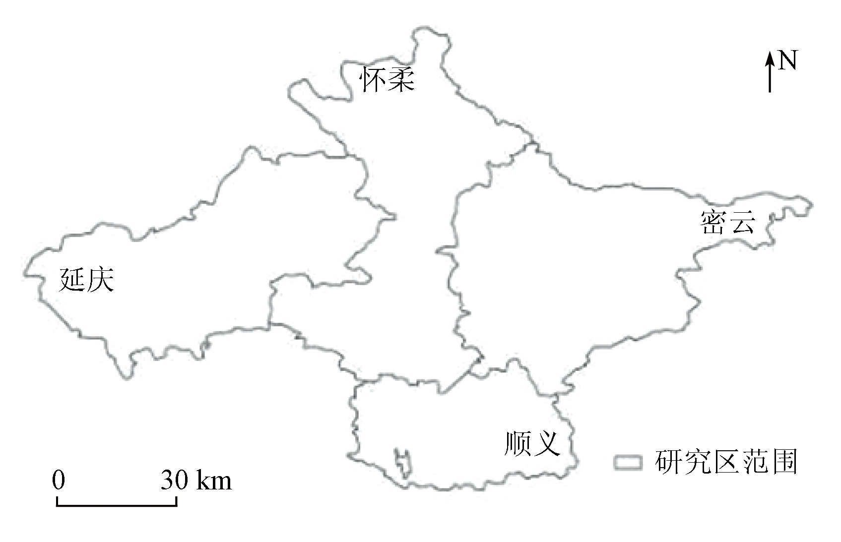
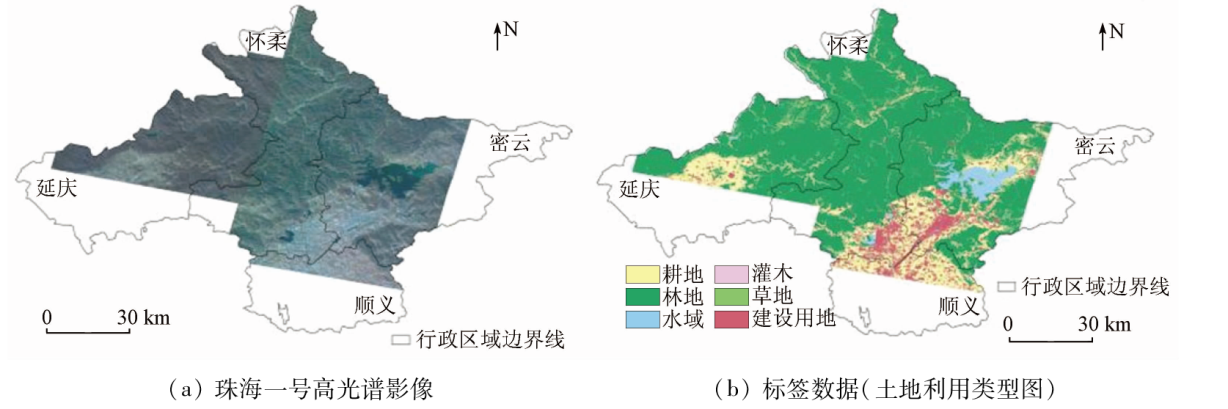
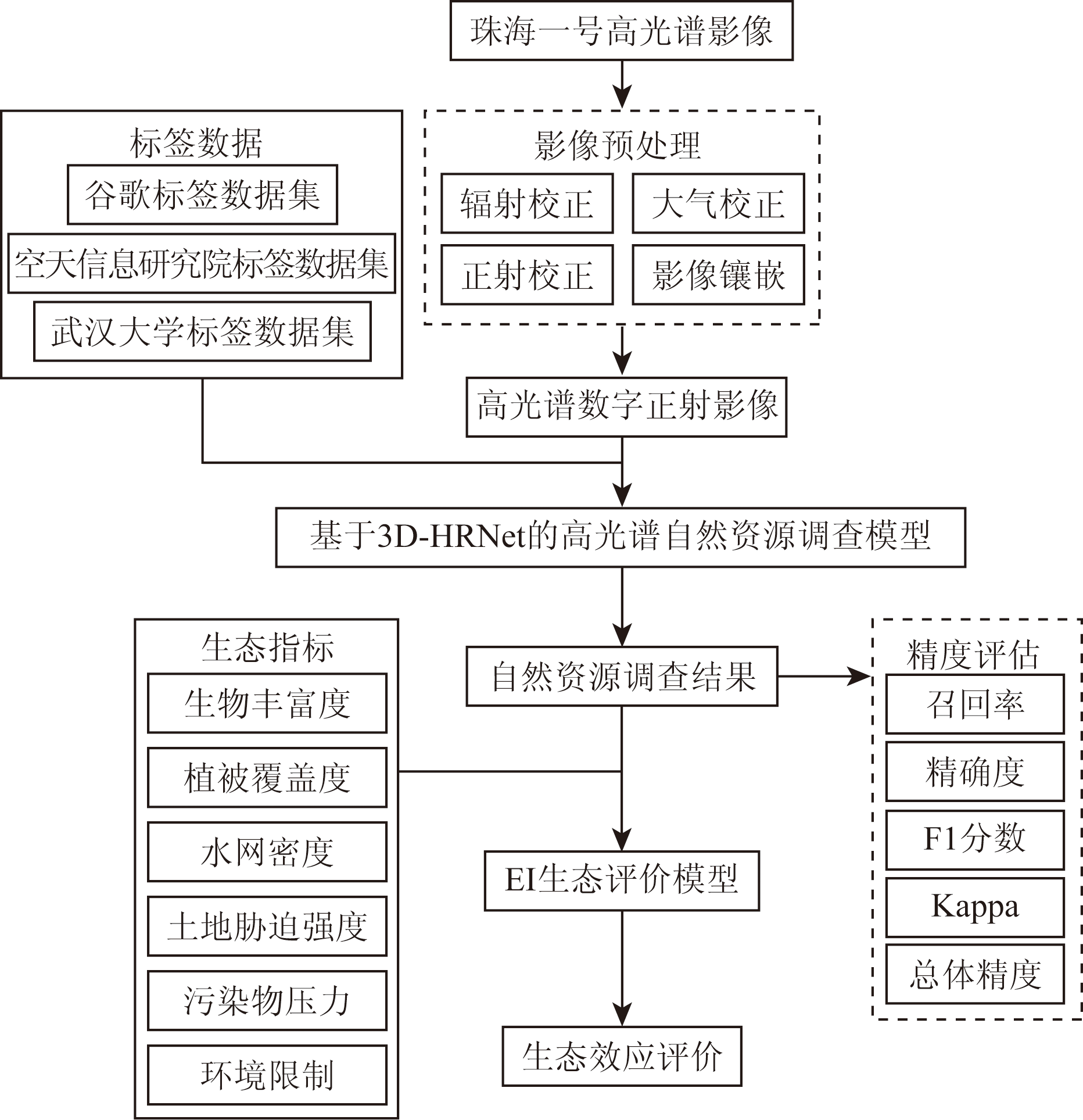
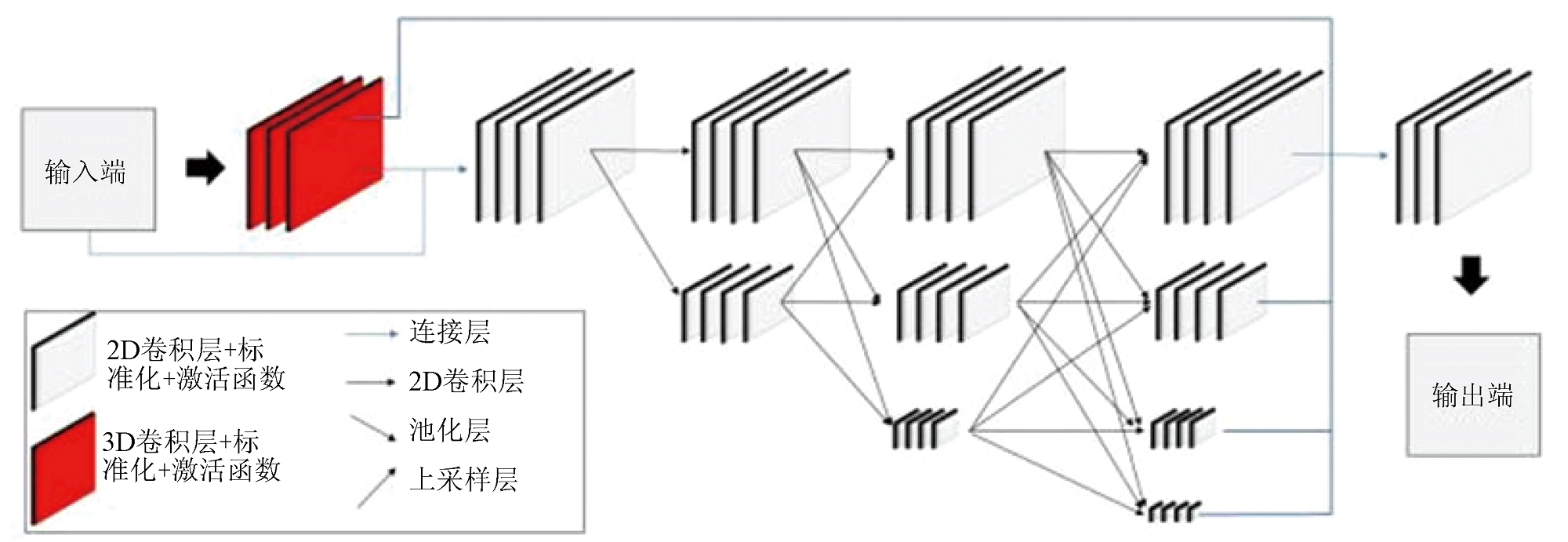
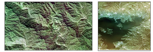
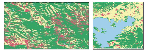
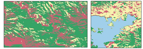
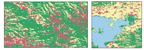
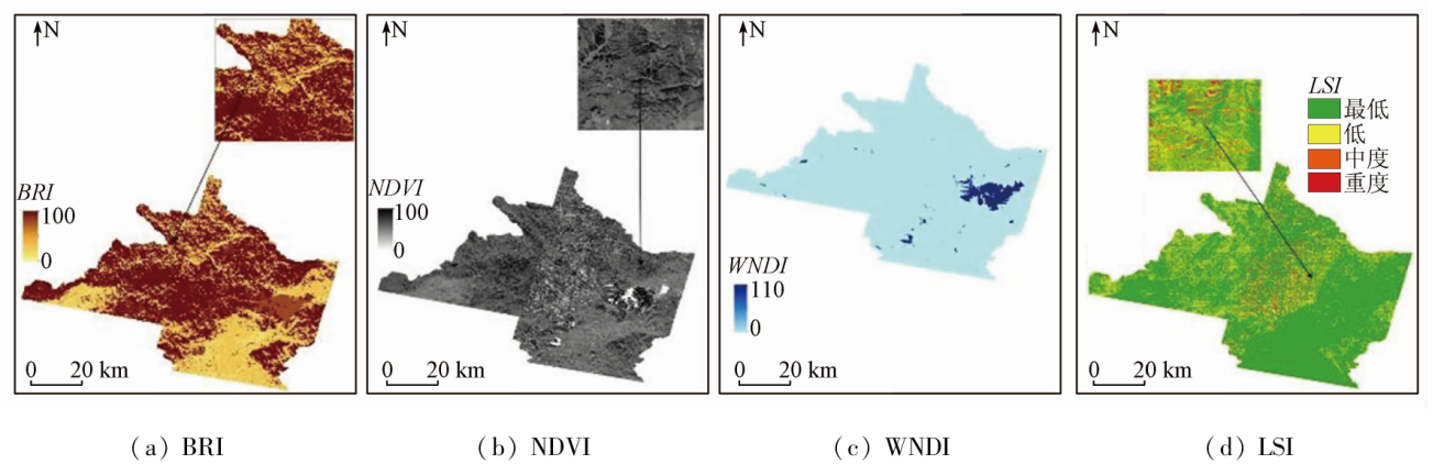
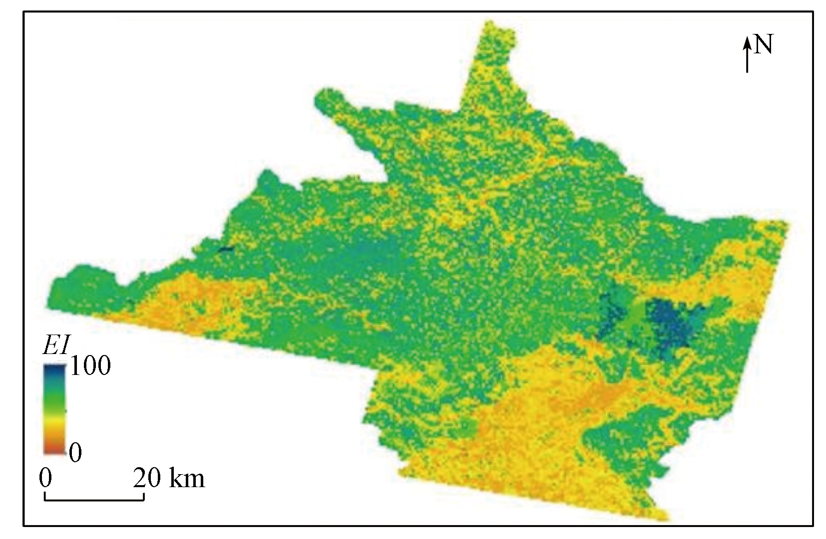
Abstract The combination of remote sensing and deep learning is efficient in the monitoring and evaluation of natural resources. Based on the comprehensive consideration of the characteristics of Zhuhai-1 OHS hyperspectral images, this study established the 3D-HRNet architecture by introducing the 3D convolutional module into the HRNet architecture and applied it to the semantic segmentation model for natural resources survey and monitoring. Using remote sensing images, this study established an ecological index (EI) evaluation model by calculating the species richness index, vegetation index, water network density index, land stress index, pollution load index, and environmental regulation index. Then, the model was employed to monitor and evaluate the natural resources in partial areas in the northern part of Beijing. The results show that: ① when being used to extract the natural resources, the 3D-HRNet model yielded average overall accuracy, a F1 score, and a Kappa coefficient of 0.83, 0.83, and 0.73, respectively, which were 0.04, 0.04, and 0.06 higher than those of the HRNet model, and 0.04, 0.05 and 0.06 higher than those of 3D-CNN model, respectively. This suggests that the 3D-HRNet model can extract natural resources from hyperspectral images more effectively than the HRNet model. In other words, the 3D convolutional module can utilize the inter-hyperspectral features to extract information more effectively; ② The eco-environment of partial areas in north Beijing in 2020 was evaluated using the EI evaluation model, with an average EI value of 68.2. This reflects a good ecological state in the study area, highly consistent with the conclusion of the Report on the State of the Ecology and Environment in Beijing, demonstrating the feasibility of remote sensing for ecological assessment. Therefore, this study provides an innovative method for the spatio-temporal analysis of the regional ecological state.
|
| Keywords
3D-HRNet
Zhuhai-1 OHS hyperspectral image
natural resources survey and monitoring
EI evaluation
|
|
|
|
Issue Date: 21 December 2023
|
|
|
| [1] |
Trabelsi M, Mandart E, Le Grusse P, et al. ESSIMAGE:A tool for the assessment of the agroecological performance of agricultural production systems[J]. Environmental Science and Pollution Research, 2019, 26(9):9257-9280.
doi: 10.1007/s11356-019-04387-9
|
| [2] |
Boeraeve F, Dendoncker N, Cornélis J T, et al. Contribution of agroecological farming systems to the delivery of ecosystem services[J]. Journal of Environmental Management, 2020, 260:109576.
doi: 10.1016/j.jenvman.2019.109576
url: https://linkinghub.elsevier.com/retrieve/pii/S0301479719312940
|
| [3] |
Aubin J, Callier M, Rey-Valette H, et al. Implementing ecological intensification in fish farming:Definition and principles from contrasting experiences[J]. Reviews in Aquaculture, 2019, 11(1):149-167.
doi: 10.1111/raq.12231
|
| [4] |
Wei L, Yu M, Zhong Y, et al. Spatial-spectral fusion based on conditional random fields for the fine classification of crops in UAV-borne hyperspectral remote sensing imagery[J]. Remote Sensing, 2019, 11(7):780.
doi: 10.3390/rs11070780
url: https://www.mdpi.com/2072-4292/11/7/780
|
| [5] |
Uddin M P, Al Mamun M, Ali Hossain M. PCA-based feature reduction for hyperspectral remote sensing image classification[J]. IETE Technical Review, 2021, 38(4):377-396.
doi: 10.1080/02564602.2020.1740615
url: https://www.tandfonline.com/doi/full/10.1080/02564602.2020.1740615
|
| [6] |
Papp L, van Leeuwen B, Szilassi P, et al. Monitoring invasive plant species using hyperspectral remote sensing data[J]. Land, 2021, 10(1):29.
doi: 10.3390/land10010029
url: https://www.mdpi.com/2073-445X/10/1/29
|
| [7] |
Ren S, He K, Girshick R, et al. Faster R-CNN:Towards real-time object detection with region proposal networks[J]. IEEE Transactions on Pattern Analysis and Machine Intelligence, 2017, 39(6):1137-1149.
doi: 10.1109/TPAMI.2016.2577031
url: http://ieeexplore.ieee.org/document/7485869/
|
| [8] |
Liu H, Luo J C, Huang B, et al. DE-net:Deep encoding network for building extraction from high-resolution remote sensing imagery[J]. Remote Sensing, 2019, 11(20):2380.
doi: 10.3390/rs11202380
url: https://www.mdpi.com/2072-4292/11/20/2380
|
| [9] |
Zhu Q, Liao C, Hu H, et al. MAP-net:Multiple attending path neural network for building footprint extraction from remote sensed imagery[J]. IEEE Transactions on Geoscience and Remote Sensing, 2021, 59(7):6169-6181.
doi: 10.1109/TGRS.2020.3026051
url: https://ieeexplore.ieee.org/document/9212557/
|
| [10] |
Santara A, Mani K, Hatwar P, et al. BASS net:Band-adaptive spectral-spatial feature learning neural network for hyperspectral image classification[J]. IEEE Transactions on Geoscience and Remote Sensing, 2017, 55(9):5293-5301.
doi: 10.1109/TGRS.2017.2705073
url: http://ieeexplore.ieee.org/document/7938656/
|
| [11] |
Pan B, Shi Z, Xu X. R-VCANet:A new deep-learning-based hyperspectral image classification method[J]. IEEE Journal of Selected Topics in Applied Earth Observations and Remote Sensing, 2017, 10(5):1975-1986.
doi: 10.1109/JSTARS.4609443
url: https://ieeexplore.ieee.org/xpl/RecentIssue.jsp?punumber=4609443
|
| [12] |
Chen Y, Jiang H, Li C, et al. Deep feature extraction and classification of hyperspectral images based on convolutional neural networks[J]. IEEE Transactions on Geoscience and Remote Sensing, 2016, 54(10):6232-6251.
doi: 10.1109/TGRS.2016.2584107
url: http://ieeexplore.ieee.org/document/7514991/
|
| [13] |
Li Y, Zhang H, Shen Q. Spectral-spatial classification of hyperspectral imagery with 3D convolutional neural network[J]. Remote Sensing, 2017, 9(1):67.
doi: 10.3390/rs9010067
url: http://www.mdpi.com/2072-4292/9/1/67
|
| [14] |
中华人民共和国环境保护部. HJ192—2015 生态环境状况评价技术规范[S]. 北京: 中国环境科学出版社, 2015.
|
| [14] |
Ministry of Environmental Protection of the People’s Republic of China. HJ192—2015 Technical Criterion for Ecosystem Status Evaluation[S]. Beijing: China Environmental Science Press, 2015.
|
| [15] |
Ryschawy J, Dumont B, Therond O, et al. Review:An integrated graphical tool for analysing impacts and services provided by livestock farming[J]. animal, 2019, 13(8):1760-1772.
doi: 10.1017/S1751731119000351
pmid: 30827290
|
| [16] |
徐涵秋. 区域生态环境变化的遥感评价指数[J]. 中国环境科学, 2013, 33(5):889-897.
|
| [16] |
Xu H Q. A remote sensing index for assessment of regional ecological changes[J]. China Environmental Science, 2013, 33(5):889-897.
|
| [17] |
Wang Q, Gao M, Zhang H. Agroecological efficiency evaluation based on multi-source remote sensing data in a typical county of the Tibetan Plateau[J]. Land, 2022, 11(4):561.
doi: 10.3390/land11040561
url: https://www.mdpi.com/2073-445X/11/4/561
|
| [18] |
赵文慧, 李令军, 鹿海峰, 等. 2015—2017年北京及近周边平房燃煤散烧及其污染排放遥感测算[J]. 环境科学, 2019, 40(4):1594-1603.
|
| [18] |
Zhao W H, Li L J, Lu H F, et al. Estimation of coal consumption and the emission of related contaminants in the plain area around Beijing during 2015—2017[J]. Environmental Science, 2019, 40(4):1594-1603.
|
| [19] |
冯天时, 庞治国, 江威. 基于珠海一号高光谱卫星的巢湖叶绿素a浓度反演[J]. 光谱学与光谱分析, 2022, 42(8):2642-2648.
|
| [19] |
Feng T S, Pang Z G, Jiang W. Remote sensing retrieval of chlorophyll-a concentration in Lake Chaohu based on Zhuhai-1 hyperspectral satellite[J]. Spectroscopy and Spectral Analysis, 2022, 42(8):2642-2648.
|
| [20] |
Yang J, Huang X. The 30 m annual land cover dataset and its dynamics in China from 1990 to 2019[J]. Earth System Science Data, 2021, 13(8):3907-3925.
doi: 10.5194/essd-13-3907-2021
url: https://essd.copernicus.org/articles/13/3907/2021/
|
| [21] |
Zhang X, Liu L, Wu C, et al. Development of a global 30 m impervious surface map using multisource and multitemporal remote sensing datasets with the Google Earth Engine platform[J]. Earth System Science Data, 2020, 12(3):1625-1648.
doi: 10.5194/essd-12-1625-2020
url: https://essd.copernicus.org/articles/12/1625/2020/
|
| [22] |
Brown C F, Brumby S P, Guzder-Williams B, et al. Dynamic World,Near real-time global 10 m land use land cover mapping[J]. Scientific Data, 2022, 9:251.
doi: 10.1038/s41597-022-01307-4
|
| [23] |
陈智朗, 付振华, 朱紫阳, 等. 基于HRNet的高分辨率遥感影像建筑物变化信息提取[J]. 测绘通报, 2022(5):126-132.
doi: 10.13474/j.cnki.11-2246.2022.0153
|
| [23] |
Chen Z L, Fu Z H, Zhu Z Y, et al. HRNet-based extraction of building change information from high-resolution remote sensing images[J]. Bulletin of Surveying and Mapping, 2022(5):126-132.
doi: 10.13474/j.cnki.11-2246.2022.0153
|
| [24] |
张伯树, 张志华, 张洋. 改进的HRNet应用于路面裂缝分割与检测[J]. 测绘通报, 2022(3):83-89.
doi: 10.13474/j.cnki.11-2246.2022.0082
|
| [24] |
Zhang B S, Zhang Z H, Zhang Y. Improved HRNet applied to segmentation and detection of pavement cracks[J]. Bulletin of Surveying and Mapping, 2022(3):83-89.
doi: 10.13474/j.cnki.11-2246.2022.0082
|
| [25] |
粟日, 宋剑, 汪政, 等. 基于3D卷积神经网络的中耳疾病高分辨率CT图像辅助分类诊断模型的应用[J]. 中南大学学报(医学版), 2022, 47(8):1037-1048.
|
| [25] |
Su R, Song J, Wang Z, et al. Application of high resolution computed tomography image assisted classification model of middle ear diseases based on 3D-convolutional neural network[J]. Journal of Central South University (Medical Science), 2022, 47(8):1037-1048.
|
| [26] |
钟帆, 柏正尧. 采用动态残差图卷积的3D点云超分辨率[J]. 浙江大学学报(工学版), 2022, 56(11):2251-2259.
|
| [26] |
Zhong F, Bai Z Y. 3D point cloud super-resolution with dynamic residual graph convolutional networks[J]. Journal of Zhejiang University (Engineering Science), 2022, 56(11):2251-2259.
|
| [27] |
郑宗生, 刘海霞, 王振华, 等. 改进3D-CNN的高光谱图像地物分类方法[J]. 自然资源遥感, 2023, 35(2):105-111.doi:10.6046/zrzyyg.2022100.
|
| [27] |
Zheng Z S, Liu H X, Wang Z H, et al. Improved 3D-CNN-based hyperspectral image classification method[J]. Remote Sensing for Natural Resources, 2023, 35(2):105-111.doi:10.6046/zrzyyg.2022100.
|
| [28] |
金永涛, 杨秀峰, 高涛, 等. 基于面向对象与深度学习的典型地物提取[J]. 国土资源遥感, 2018, 30(1):22-29.doi:10.6046/gtzyyg.2018.01.04.
|
| [28] |
Jin Y T, Yang X F, Gao T, et al. The typical object extraction method based on object-oriented and deep learning[J]. Remote Sensing for Land and Resources, 2018, 30(1):22-29.doi:10.6046/gtzyyg.2018.01.04.
|
|
Viewed |
|
|
|
Full text
|
|
|
|
|
Abstract
|
|
|
|
|
Cited |
|
|
|
|
| |
Shared |
|
|
|
|
| |
Discussed |
|
|
|
|
 2023,
Vol. 35
2023,
Vol. 35
 ), LIN Zhen1, TANG Tingyuan2, LI Chuyu2(