|
|
 |
|

|
|
|
Multi-scenario simulation and prediction of land use in the Pearl River Delta urban agglomeration using the coupled Markov-FLUS model |
CHAI Xinyu1( ), WU Xianwen1(), CHEN Xiaohui2, WANG Yu3, ZHAO Xingtao3 ), WU Xianwen1(), CHEN Xiaohui2, WANG Yu3, ZHAO Xingtao3 |
1. Guangdong Polytechnic of Industry and Commerce, Guangzhou 510510, China
2. Jilin Institute of Architecture and Technology, Changchun 130114, China
3. Beijing KingGIS Technology Co., Ltd, Beijing100021, China |
|
|
|
|
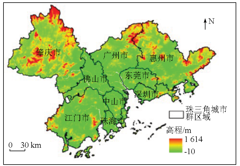
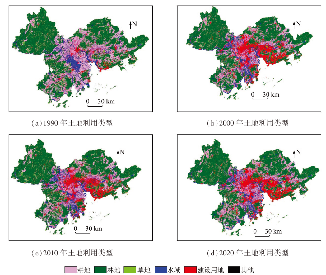
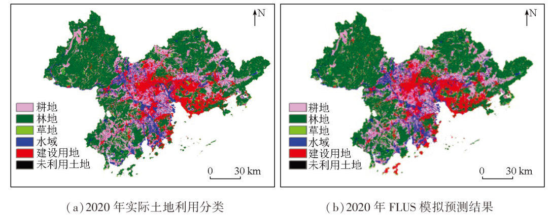
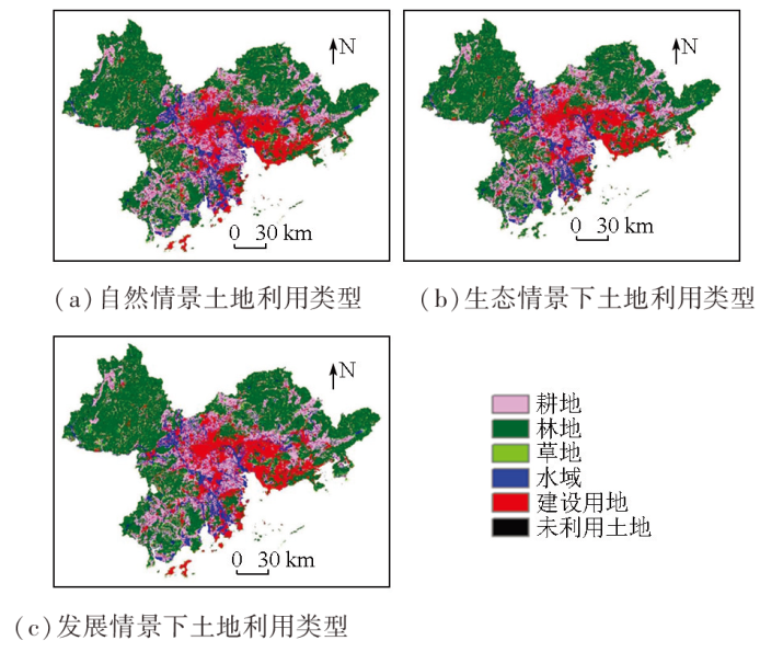
Abstract Land use demands vary under different development objectives. Scientifically and rationally regulating changes in land use are crucial to efficient land resource utilization and achieving ecological, developmental, and economic coordination in the Pearl River Delta urban agglomeration. Based on the land use data of the urban agglomeration of 1990, 2000, 2010, and 2020 and using the FLUS-Markov model, this study predicted the quantity and spatial changes in land use in the Pearl River Delta urban agglomeration by 2035 under three scenarios: natural development, ecological protection, and development priority. Furthermore, this study determined the differences in land use change under the three scenarios. Additionally, a simulation analysis of the land use in 2035 was conducted to facilitate the optimized land and space allocation under varying developmental objectives. The results indicate significant changes in the use of construction land in the Pearl River Delta urban agglomeration. From 1990 to 2020, the area of construction land, including urban land and infrastructure land increased by 4 945.25 km2, representing an increase of 2.8 times. The simulations and predictions under three land use scenarios reveal that the urban land area will trend upward by the end of 2034, with its expansion speed being restricted under the ecological protection scenario, while the ecological land, such as forest land, grassland, and water area, will maintain an increasing trend until 2035. From 1990 to 2020, the arable land area decreased by 3 759.5 km2. Under the three land use scenarios, the trend of arable land reduction will continuously decrease until 2035, with the decreasing trends slowing down from 2020 to 2035. Especially, under the development scenario, the area of construction land will continue to increase, the decreasing trend of the arable land area will be somewhat curbed, while the area of grassland and forest land will undergo a more serious decrease. Although dominant factors affecting arable land protection in the Pearl River Delta urban agglomeration vary across different development stages, the main factor is infrastructure construction such as rail transit roads.
|
| Keywords
Markov model
FLUS model
land use change
simulated prediction
|
|
|
|
Issue Date: 09 May 2025
|
|
|
| [1] |
李少英, 刘小平, 黎夏, 等. 土地利用变化模拟模型及应用研究进展[J]. 遥感学报, 2017, 21(3):329-340.
|
| [1] |
Li S Y, Liu X P, Li X, et al. Simulation model of land use dynamics and application:Progress and prospects[J]. Journal of Remote Sensing, 2017, 21(3):329-340.
|
| [2] |
Chen L, Su W, Li M, et al. A population randomization-based multi-objective genetic algorithm for gesture adaptation in human-robot interaction[J]. Science China Information Sciences, 2020, 64(1):112208.
|
| [3] |
方赞山, 钟才荣, 王凤霞, 等. 耦合InVEST与FLUS模型的海南岛生态系统碳储量时空演变与预测[J]. 水土保持通报, 2023, 43(5):320-329,342.
|
| [3] |
Fang Z S, Zhong C R, Wang F X, et al. Spatial-temporal evolution and prediction of ecosystem carbon storage on Hainan Island by coupling InVEST and FLUS models[J]. Bulletin of Soil and Water Conservation, 2023, 43(5):320-329,342.
|
| [4] |
赵莉, 杨俊, 李闯, 等. 地理元胞自动机模型研究进展[J]. 地理科学, 2016, 36(8):1190-1196.
doi: 10.13249/j.cnki.sgs.2016.08.009
|
| [4] |
Zhao L, Yang J, Li C, et al. Progress on geographic cellular automata model[J]. Scientia Geographica Sinica, 2016, 36(8):1190-1196.
|
| [5] |
王芳莉. 基于FLUS模型的陇南市土地利用变化与模拟[D]. 兰州: 西北师范大学, 2020.
|
| [5] |
Wang F L. Change and simulation of land use in Longnan City based on FLUS model[D]. Lanzhou: Northwest Normal University, 2020.
|
| [6] |
邱应美. 基于Markov和FLUS模型的全福庄聚落演变与土地利用空间优化研究[D]. 昆明: 云南师范大学, 2020.
|
| [6] |
Qiu Y M. Study on settlements evolution and spatial optimization of land use in the Quanfuzhuang by means of Markov and FLUS models[D]. Kunming: Yunnan Normal University, 2020.
|
| [7] |
杜际增, 王根绪, 李元寿. 基于马尔科夫链模型的长江源区土地覆盖格局变化特征[J]. 生态学杂志, 2015, 34(1):195-203.
|
| [7] |
Du J Z, Wang G X, Li Y S. Changes of land cover pattern in the source region of Yangtze River based on Markov process[J]. Chinese Journal of Ecology, 2015, 34(1):195-203.
|
| [8] |
王佐霖, 黄钰辉, 杨龙, 等. 深圳森林生态系统类型自然保护区近20年土地利用与景观格局变化[J]. 林业与环境科学, 2019, 35(2):1-6.
|
| [8] |
Wang Z L, Huang Y H, Yang L, et al. Dynamics of land use and landscape pattern of forest ecosystem nature reserve in Shenzhen in recent 20 years[J]. Forestry and Environmental Science, 2019, 35(2):1-6.
|
| [9] |
任胤铭, 刘小平, 许晓聪, 等. 基于FLUS-InVEST模型的京津冀多情景土地利用变化模拟及其对生态系统服务功能的影响[J]. 生态学报, 2023, 43(11):4473-4487.
|
| [9] |
Ren Y M, Liu X P, Xu X C, et al. Multi-scenario simulation of land use change and its impact on ecosystem services in Beijing-Tianjin-Hebei Region based on the FLUS-InVEST Model[J]. Acta Ecologica Sinica, 2023, 43(11):4473-4487.
|
| [10] |
王旭, 马伯文, 李丹, 等. 基于FLUS模型的湖北省生态空间多情景模拟预测[J]. 自然资源学报, 2020, 35(1):230-242.
doi: 10.31497/zrzyxb.20200119
|
| [10] |
Wang X, Ma B W, Li D, et al. Multi-scenario simulation and prediction of ecological space in Hubei Province based on FLUS model[J]. Journal of Natural Resources, 2020, 35(1):230-242.
doi: 10.31497/zrzyxb.20200119
|
| [11] |
Wang X, Ma B W, Li D, et al. Multi-scenario simulation and prediction of ecological space in Hubei Province based on FLUS model[J]. Journal of Natural Resources, 2020, 35(1):230.
doi: 10.31497/zrzyxb.20200119
|
| [12] |
Oliver M A, Webster R. A tutorial guide to geostatistics:Computing and modelling variograms and Kriging[J]. Catena, 2014, 113:56-69.
|
| [13] |
胡最, 王慧. 多因素约束的城市空间扩张元胞自动机构建及其应用研究[J]. 地球信息科学学报, 2020, 22(3):616-627.
doi: 10.12082/dqxxkx.2020.190240
|
| [13] |
Hu Z, Wang H. MCES-CA based urban expansion simulation of Hengyang city[J]. Journal of Geo-Information Science, 2020, 22(3):616-627.
|
| [14] |
陈理庭, 蔡海生, 张婷, 等. 基于Markov-FLUS模型的饶河流域土地利用多情景模拟分析[J]. 生态学报, 2022, 42(10):3947-3958.
|
| [14] |
Chen L T, Cai H S, Zhang T, et al. Land use multi-scenario simulation analysis of Rao River Basin based on Markov-FLUS model[J]. Acta Ecologica Sinica, 2022, 42(10):3947-3958.
|
| [15] |
李立, 胡睿柯, 李素红. 基于改进FLUS模型的北京市低碳土地利用情景模拟[J]. 自然资源遥感, 2023, 35(1):81-89.doi: 10.6046/zrzyyg.2022065.
|
| [15] |
Li L, Hu R K, Li S H. Simulations of the low-carbon land use scenarios of Beijing based on the improved FLUS model[J]. Remote Sensing for Natural Resources, 2023, 35(1):81-89.doi: 10.6046/zrzyyg.2022065.
|
| [16] |
王佳楠, 张志. 基于Markov-PLUS模型的柴北缘土地利用变化及模拟分析[J]. 西北林学院学报, 2022, 37(3):139-148,179.
|
| [16] |
Wang J N, Zhang Z. Land use change and simulation analysis in the northern margin of the Qaidam Basin based on Markov-PLUS model[J]. Journal of Northwest Forestry University, 2022, 37(3):139-148,179.
|
| [17] |
谢凌凌, 许进龙, 臧俊梅, 等. 基于Markov-FLUS模型的广西土地利用变化模拟预测[J]. 水土保持研究, 2022, 29(2):249-254,264.
|
| [17] |
Xie L L, Xu J L, Zang J M, et al. Simulation and prediction of land use change in Guangxi based on Markov-FLUS model[J]. Research of Soil and Water Conservation, 2022, 29(2):249-254,264.
|
| [18] |
Deal B, Farello C, Lancaster M, et al. A dynamic model of the spatial spread of an infectious disease:The case of fox rabies in Illinois[J]. Environmental Modeling and Assessment, 2000, 5(1):47-62.
|
| [19] |
Liu X, Liang X, Li X, et al. A future land use simulation model (FLUS) for simulating multiple land use scenarios by coupling human and natural effects[J]. Landscape and Urban Planning, 2017, 168:94-116.
|
| [20] |
Ji Z, Wei H, Xue D, et al. Trade-off and projecting effects of land use change on ecosystem services under different policies scenarios:A case study in central China[J]. International Journal of Environmental Research and Public Health, 2021, 18(7):3552.
|
| [21] |
戴文远, 江方奇, 黄万里, 等. 基于“三生空间” 的土地利用功能转型及生态服务价值研究——以福州新区为例[J]. 自然资源学报, 2018, 33(12):2098-2109.
doi: 10.31497/zrzyxb.20171197
|
| [21] |
Dai W Y, Jiang F Q, Huang W L, et al. Study on transition of land use function and ecosystem service value based on the conception of production,living and ecological space:A case study of the Fuzhou new area[J]. Journal of Natural Resources, 2018, 33(12):2098-2109.
|
| [22] |
苏迎庆, 刘庚, 赵景波, 等. 基于FLUS模型的汾河流域生态空间多情景模拟预测[J]. 干旱区研究, 2021, 38(4):1152-1161.
doi: 10.13866/j.azr.2021.04.27
|
| [22] |
Su Y Q, Liu G, Zhao J B, et al. Multi-scenario simulation prediction of ecological space in the Fenhe River Basin using the FLUS model[J]. Arid Zone Research, 2021, 38(4):1152-1161.
doi: 10.13866/j.azr.2021.04.27
|
| [23] |
姜展鹏, 包安明, 李艳红. 基于GeoSOS-FLUS模型的乌鲁木齐主城区扩张情景模拟分析[J]. 遥感技术与应用, 2023, 38(2):332-340.
doi: 10.11873/j.issn.1004-0323.2023.2.0332
|
| [23] |
Jiang Z P, Bao A M, Li Y H. Scenario simulation analysis of Urumqi urban sprawl based on GeoSOS-FLUS model[J]. Remote Sensing Technology and Application, 2023, 38(2):332-340.
|
|
Viewed |
|
|
|
Full text
|
|
|
|
|
Abstract
|
|
|
|
|
Cited |
|
|
|
|
| |
Shared |
|
|
|
|
| |
Discussed |
|
|
|
|
 2025,
Vol. 37
2025,
Vol. 37