|
|
 |
|

|
|
|
Identification of ecologic zones based on ecosystem service value and ecological risk index from a perspective of spatiotemporal dynamics: A case study of Qinhuangdao City, Hebei Province |
ZHENG Jiaxin1,2( ), PEI Xiaolong2,3(), SONG Dongyang2, TIAN Rui1, ZHAO Zhongqiu1,4, BAI Hang1 ), PEI Xiaolong2,3(), SONG Dongyang2, TIAN Rui1, ZHAO Zhongqiu1,4, BAI Hang1 |
1. School of Land Science and Technology, China University of Geosciences (Beijing), Beijing 100083, China
2. Langfang Natural Resources Comprehensive Survey Center, China Geological Survey, Langfang 065000, China
3. Key Laboratory of Coupling Process and Effect of Natural Resources Elements, Beijing 100055, China
4. Key Laboratory of Land Consolidation and Rehabilitation, Ministry of Natural Resources, Beijing 100035, China |
|
|
|
|
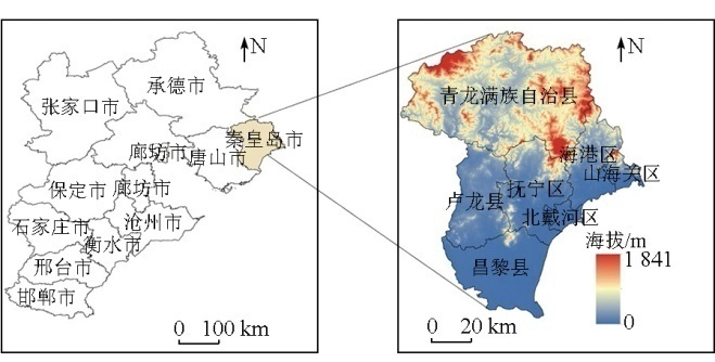
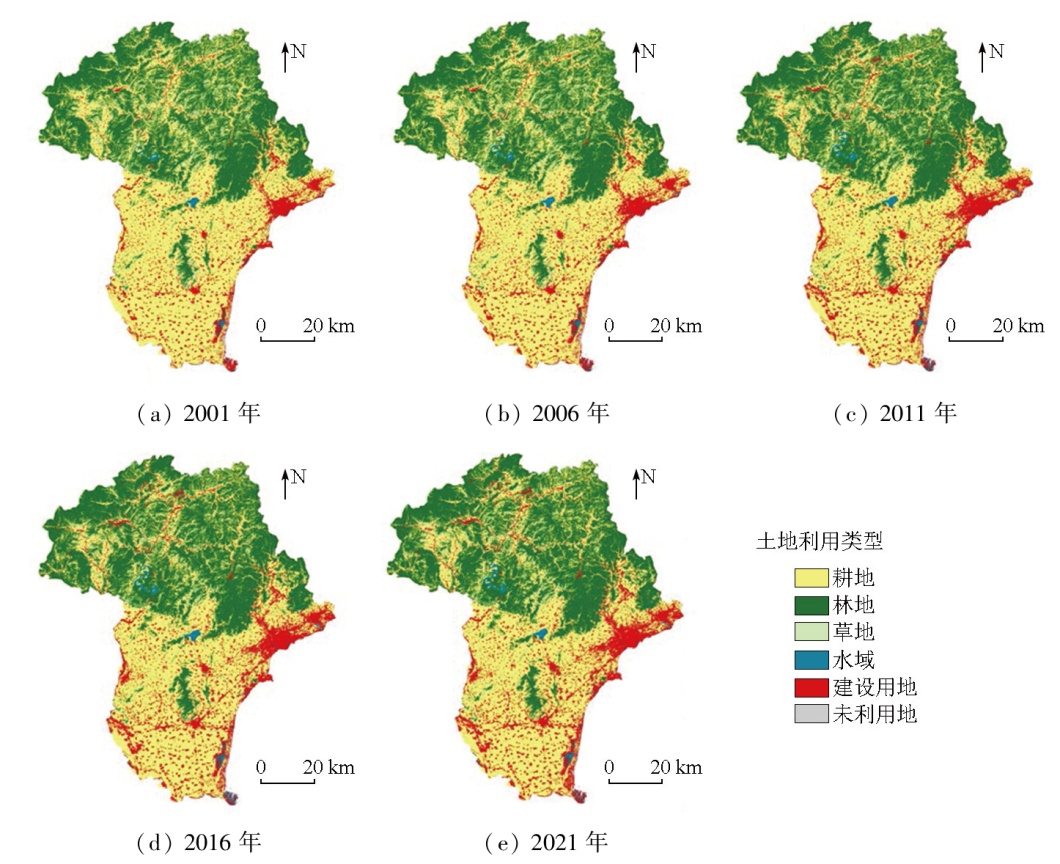
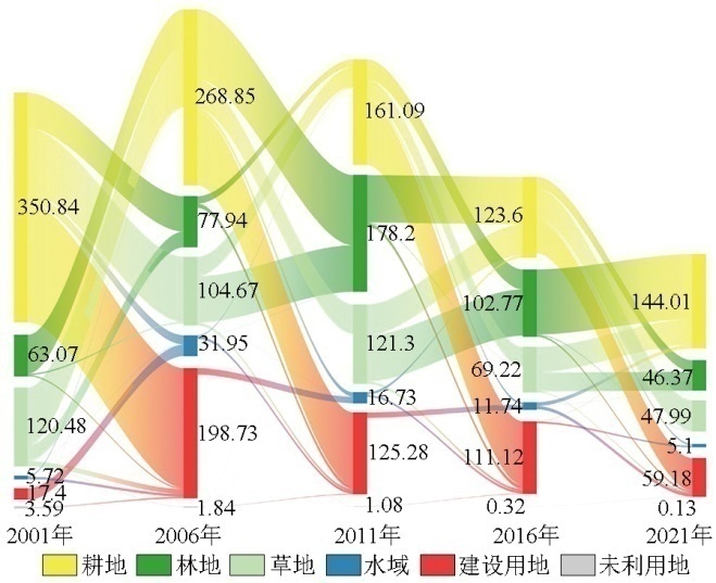
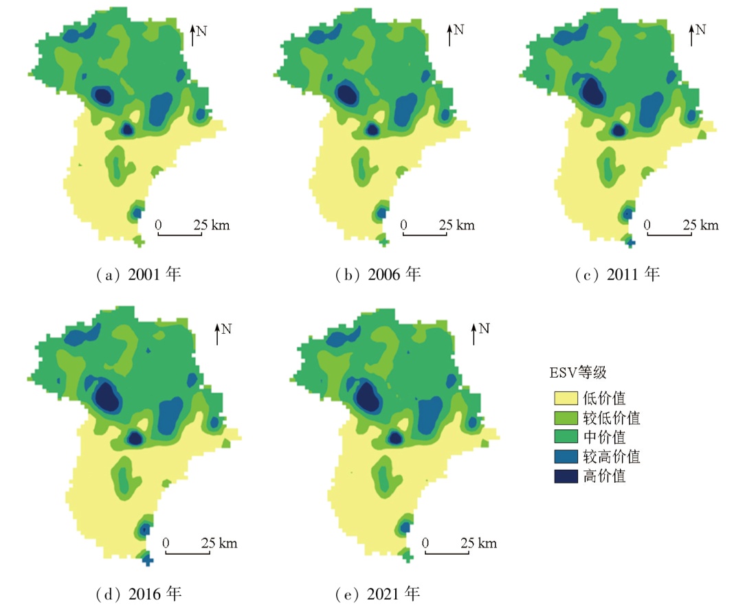
Abstract Under the influence of climate change and human activities, the increasing risk of ecological service degradation poses a significant challenge to regional ecological security. Exploring ecologic zones based on ecosystem service value (ESV) and landscape ecological risk index (ERI) enables an intuitive identification of the regional ecological function status, thereby providing a basis for regional ecosystem conservation. This study investigated Qinhuangdao City in Hebei Province, China, by integrating landscape ecology, equivalent factor, GIS grid, and spatial autocorrelation methods. Under the whole-process dynamic control framework, this study analyzed the spatiotemporal dynamics of ESV and ERI from 2001 to 2021, revealing their evolutionary patterns. Moreover, based on the value-risk spatial aggregation patterns, this study determined the ecologic zones in Qinhuangdao City. The results indicate that over the past two decades, the ESV in Qinhuangdao City exhibited overall slight variations, with an increase of about 0.073 billion yuan, presenting a spatial pattern characterized by alternatively distributed large dispersion and small aggregation. The average ERI value showed a fluctuating downward trend, gradually shifting toward lower risk, with higher ERI values in the north compared to the south. The evolutionary types of ESV and ERI in Qinhuangdao City can be classified into maintenance, upgrading, mitigation, and fluctuation types, with the maintenance type representing the largest proportion. A positive correlation was observed between ESV and ERI per unit area in Qinhuangdao City, dominated by zones with high ESV and ERI in the northern part of Qinhuangdao City.
|
| Keywords
ecosystem service value (ESV)
landscape ecological risk
land use change
spatiotemporal dynamics
ecologic zone
|
|
|
|
Issue Date: 01 July 2025
|
|
|
| [1] |
Daily G C. Nature’s services:Societal dependence on natural ecosystems[M]. Washington,DC: Island Press, 1997.
|
| [2] |
欧阳志云, 郑华. 生态系统服务的生态学机制研究进展[J]. 生态学报, 2009, 29(11):6183-6188.
|
| [2] |
Ouyang Z Y, Zheng H. Ecological mechanisms of ecosystem ser-vices[J]. Acta Ecologica Sinica, 2009, 29(11):6183-6188.
|
| [3] |
李超, 牛文浩, 黄怀玉, 等. 城市化背景下粤港澳大湾区生态风险时空演变及生态分区识别研究[J]. 环境工程技术学报, 2024, 14(2):562-573.
|
| [3] |
Li C, Niu W H, Huang H Y,et al. Study on spatial and temporal evolution of ecological risk and ecological zoning identification in Guangdong-Hong Kong-Macao Greater Bay Area under the background of urbanization[J]. Journal of Environmental Engineering Technology, 2024, 14(2):562-573.
|
| [4] |
郑善文, 何永, 欧阳志云. 我国城市总体规划生态考量的不足及对策探讨[J]. 规划师, 2017, 33(5):39-46.
|
| [4] |
Zheng S W, He Y, Ouyang Z Y. Inadequate ecological consideration in urban master plan and countermeasures[J]. Planners, 2017, 33(5):39-46.
|
| [5] |
Xie H L, Wen J M, Chen Q R, et al. Evaluating the landscape ecological risk based on GIS:A case-study in the Poyang Lake region of China[J]. Land Degradation and Development, 2021, 32(9):2762-2774.
|
| [6] |
梁仕豪, 李文, 高宇, 等. 吉林省生态系统服务价值与景观生态风险关联性及其空间分异[J]. 应用生态学报, 2024, 35(3):769-779.
doi: 10.13287/j.1001-9332.202403.022
|
| [6] |
Liang S H, Li W, Gao Y, et al. Correlations between ecosystem service value and landscape ecological risk and its spatial heterogeneity in Jilin Province,China[J]. Chinese Journal of Applied Ecology, 2024, 35(3):769-779.
|
| [7] |
Costanza R, D’Arge R, De Groot R, et al. The value of the world’s ecosystem services and natural capital[J]. Ecological Economics, 1998, 25(1):3-15.
|
| [8] |
谢高地, 鲁春霞, 冷允法, 等. 青藏高原生态资产的价值评估[J]. 自然资源学报, 2003, 18(2):189-196.
|
| [8] |
Xie G D, Lu C X, Leng Y F, et al. Ecological assets valuation of the Tibetan Plateau[J]. Journal of Natural Resources, 2003, 18(2):189-196.
doi: 10.11849/zrzyxb.2003.02.010
|
| [9] |
谢高地, 甄霖, 鲁春霞, 等. 一个基于专家知识的生态系统服务价值化方法[J]. 自然资源学报, 2008, 23(5):911-919.
|
| [9] |
Xie G D, Zhen L, Lu C X, et al. Expert knowledge based valuation method of ecosystem services in China[J]. Journal of Natural Resources, 2008, 23(5):911-919.
doi: 10.11849/zrzyxb.2008.05.019
|
| [10] |
谢高地, 张彩霞, 张雷明, 等. 基于单位面积价值当量因子的生态系统服务价值化方法改进[J]. 自然资源学报, 2015, 30(8):1243-1254.
|
| [10] |
Xie G D, Zhang C X, Zhang L M, et al. Improvement of the evaluation method for ecosystem service value based on per unit area[J]. Journal of Natural Resources, 2015, 30(8):1243-1254.
|
| [11] |
冯凌. 土地持续利用与农民福利提升的生态服务价值补偿:理论计算与旅游实现[M]. 北京: 旅游教育出版社, 2011.
|
| [11] |
Feng L. Ecological service value compensation of sustainable land use and farmer welfare promotion:Theoretical calculation and tourism realization[M]. Beijing: Tourism Education Press, 2011.
|
| [12] |
刘志涛, 王少剑, 方创琳. 粤港澳大湾区生态系统服务价值的时空演化及其影响机制[J]. 地理学报, 2021, 76(11):2797-2813.
doi: 10.11821/dlxb202111014
|
| [12] |
Liu Z T, Wang S J, Fang C L. Spatiotemporal evolution and influencing mechanism of ecosystem service value in the Guangdong-Hong Kong-Macao Greater Bay Area[J]. Acta Geographica Sinica, 2021, 76(11):2797-2813.
doi: 10.11821/dlxb202111014
|
| [13] |
Liu W Y, Lin Y Y, Chen H S, et al. Assessing the amenity value of forest ecosystem services:Perspectives from the use of sustainable green spaces[J]. Sustainability, 2019, 11(16):4500.
|
| [14] |
徐雨晴, 於琍, 周波涛, 等. 气候变化背景下未来中国草地生态系统服务价值时空动态格局[J]. 生态环境学报, 2017, 26(10):1649-1658.
doi: 10.16258/j.cnki.1674-5906.2017.10.002
|
| [14] |
Xu Y Q, Yu L, Zhou B T, et al. Temporal-spatial dynamic pattern of grassland ecosystem service value under the background of climate change in the future in China[J]. Ecology and Environmental Sciences, 2017, 26(10):1649-1658.
|
| [15] |
赵志刚, 余德, 韩成云, 等. 鄱阳湖生态经济区生态系统服务价值预测与驱动力[J]. 生态学报, 2017, 37(24):8411-8421.
|
| [15] |
Zhao Z G, Yu D, Han C Y, et al. Ecosystem services value prediction and driving forces in the Poyang Lake Ecoeconomic Zone[J]. Acta Ecologica Sinica, 2017, 37(24):8411-8421.
|
| [16] |
覃婷, 韦立权, 龙植豪. 森林生态系统服务功能对经济社会的贡献研究——以广西西江经济带为例[J]. 山西农经, 2020(6):78-80.
|
| [16] |
Qin T, Wei L Q, Long Z H. Study on the contribution of forest ecosystem services to economy and society:A case study of Xijiang economic belt in Guangxi[J]. Shanxi Agricultural Economy, 2020(6):78-80.
|
| [17] |
郝军, 田雅楠, 戈锋, 等. 流域土地利用与景观生态风险响应关系研究[J]. 中国环境科学, 2023, 43(11):6132-6140.
|
| [17] |
Hao J, Tian Y N, Ge F, et al. Correlational relationship between land use and landscape ecological risks in Inner Mongolia section of middle Nenjiang River[J]. China Environmental Science, 2023, 43(11):6132-6140.
|
| [18] |
彭建, 党威雄, 刘焱序, 等. 景观生态风险评价研究进展与展望[J]. 地理学报, 2015, 70(4):664-677.
doi: 10.11821/dlxb201504013
|
| [18] |
Peng J, Dang W X, Liu Y X, et al. Review on landscape ecological risk assessment[J]. Acta Geographica Sinica, 2015, 70(4):664-677.
doi: 10.11821/dlxb201504013
|
| [19] |
陈鹏, 潘晓玲. 干旱区内陆流域区域景观生态风险分析——以阜康三工河流域为例[J]. 生态学杂志, 2003, 22(4):116-120.
|
| [19] |
Chen P, Pan X L. Ecological risk analysis of regional landscape in inland river watershed of arid area:A case study of Sangong River Basin in Fukang[J]. Chinese Journal of Ecology, 2003, 22(4):116-120.
|
| [20] |
陈心怡, 谢跟踪, 张金萍. 海口市海岸带近30年土地利用变化的景观生态风险评价[J]. 生态学报, 2021, 41(3):975-986.
|
| [20] |
Chen X Y, Xie G Z, Zhang J P. Landscape ecological risk assessment of land use changes in the coastal area of Haikou City in the past 30 years[J]. Acta Ecologica Sinica, 2021, 41(3):975-986.
|
| [21] |
常玉旸, 高阳, 谢臻, 等. 京津冀地区生境质量与景观格局演变及关联性[J]. 中国环境科学, 2021, 41(2):848-859.
|
| [21] |
Chang Y Y, Gao Y, Xie Z, et al. Spatiotemporal evolution and spatial correlation of habitat quality and landscape pattern over Beijing-Tianjin-Hebei region[J]. China Environmental Science, 2021, 41(2):848-859.
|
| [22] |
康紫薇, 张正勇, 位宏, 等. 基于土地利用变化的玛纳斯河流域景观生态风险评价[J]. 生态学报, 2020, 40(18):6472-6485.
|
| [22] |
Kang Z W, Zhang Z Y, Wei H, et al. Landscape ecological risk assessment in Manas River Basin based on land use change[J]. Acta Ecologica Sinica, 2020, 40(18):6472-6485.
|
| [23] |
Li G, Chen W, Zhang X, et al. Ecosystem service values in the Dongting Lake eco-economic zone and the synergistic impact of its driving factors[J]. International Journal of Environmental Research and Public Health, 2022, 19(5):3121.
|
| [24] |
李静芝, 王苗, 冯文静, 等. 湘西州地区生态系统服务价值时空特征及驱动分析[J]. 自然资源遥感, 2022, 34(3):207-217.doi:10.6046/zrzyyg.2021323.
|
| [24] |
Li J Z, Wang M, Feng W J, et al. The characteristics and driving factors of spatiotemporal changes in the ecosystem service value in Xiangxi,Hunan,China[J]. Remote Sensing for Natural Resources, 2022, 34(3):207-217.doi:10.6046/zrzyyg.2021323.
|
| [25] |
文疆回, 李瑞. 贵州省生态系统服务价值时空演变及其对景观格局变化的响应[J]. 应用生态学报, 2022, 33(11):3075-3086.
doi: 10.13287/j.1001-9332.202211.020
|
| [25] |
Wen J H, Li R. Temporal and spatial variation of ecosystem service value and its response to landscape pattern change in Guizhou Province,China[J]. Chinese Journal of Applied Ecology, 2022, 33(11):3075-3086.
|
| [26] |
曹君, 张正栋, 崔峰艳, 等. 1996—2015年纽约湾区生态系统服务对景观格局变化的响应[J]. 世界地理研究, 2021, 30(4):826-838.
doi: 10.3969/j.issn.1004-9479.2021.04.2020124
|
| [26] |
Cao J, Zhang Z D, Cui F Y, et al. Response of ecosystem services to landscape pattern changes in the New York Bay Area from 1996 to 2015[J]. World Regional Studies, 2021, 30(4):826-838.
doi: 10.3969/j.issn.1004-9479.2021.04.2020124
|
| [27] |
郑博福, 黄琼瑶, 陶林, 等. 赣南地区景观格局变化及其对生态系统服务价值的影响[J]. 生态学报, 2021, 41(15):5940-5949.
|
| [27] |
Zheng B F, Huang Q Y, Tao L, et al. Landscape pattern change and its impacts on the ecosystem services value in southern Jiangxi Province[J]. Acta Ecologica Sinica, 2021, 41(15):5940-5949.
|
| [28] |
Zhang Y L, Hu X J, Wei B J, et al. Spatiotemporal exploration of ecosystem service value,landscape ecological risk,and their interactive relationship in Hunan Province,Central-South China,over the past 30 years[J]. Ecological Indicators, 2023,156:111066.
|
| [29] |
Zhang Y Y, Yang R J, Li X H, et al. Designing a sustainable development path based on landscape ecological risk and ecosystem service value in Southwest China[J]. Sustainability, 2023. 15(4):3648.
|
| [30] |
武燕, 吴映梅, 李琛, 等. 基于MAUP下川滇生态屏障区生态系统服务价值多尺度空间分异及地理探测响应[J]. 水土保持研究, 2023, 30(2):333-342.
|
| [30] |
Wu Y, Wu Y M, Li C, et al. Multi-scale spatial differentiation and geographic detection response of ecosystem service value in Sichuan-Yunnan ecological barrier based on the modifiable areal unit problem[J]. Research of Soil and Water Conservation, 2023, 30(2):333-342.
|
| [31] |
戚丽萍, 栾兆擎, 魏勉, 等. 基于土地利用的江苏省各市生态系统服务价值时空变化研究[J]. 南京林业大学学报(自然科学版), 2023, 47(4):200-208.
doi: 10.12302/j.issn.1000-2006.202109012
|
| [31] |
Qi L P, Luan Z Q, Wei M, et al. Spatial and temporal variations of ecosystem service values in Jiangsu Province based on land-use change[J]. Journal of Nanjing Forestry University (Natural Sciences Edition), 2023, 47(4):200-208.
|
| [32] |
尉芳, 刘京, 夏利恒, 等. 基于LUCC的陕西渭北旱塬区景观生态风险评价[J]. 中国环境科学, 2022, 42(4):1963-1974.
|
| [32] |
Wei F, Liu J, Xia L H, et al. Landscape ecological risk assessment in Weibei dryland region of Shaanxi Province based on LUCC[J]. China Environmental Science, 2022, 42(4):1963-1974.
|
| [33] |
乔斌, 曹晓云, 孙玮婕, 等. 基于生态系统服务价值和景观生态风险的生态分区识别与优化策略——以祁连山国家公园青海片区为例[J]. 生态学报, 2023, 43(3):986-1004.
|
| [33] |
Qiao B, Cao X Y, Sun W J, et al. Ecological zoning identification and optimization strategies based on ecosystem service value and landscape ecological risk:Taking Qinghai area of Qilian Mountain National Park as an example[J]. Acta Ecologica Sinica, 2023, 43(3):986-1004.
|
| [34] |
杨帆, 金晓斌, 刘晶, 等. 时空动态视角下快速城市化地区景观生态风险评价与分区[J]. 农业工程学报, 2023, 39(18):253-261.
|
| [34] |
Yang F, Jin X B, Liu J, et al. Assessing landscape ecological risk in rapidly urbanized areas from the perspective of spatiotemporal dynamics[J]. Transactions of the Chinese Society of Agricultural Engineering, 2023, 39(18):253-261.
|
| [35] |
李俊翰, 高明秀. 滨州市生态系统服务价值与生态风险时空演变及其关联性[J]. 生态学报, 2019, 39(21):7815-7828.
|
| [35] |
Li J H, Gao M X. Spatiotemporal evolution and correlation analysis of ecosystem service values and ecological risk in Binzhou[J]. Acta Ecologica Sinica, 2019, 39(21):7815-7828.
|
| [36] |
段维利, 余新晓, 陈丽华, 等. 京津冀城市群城镇化与生态建设对生态系统服务价值的影响[J]. 水土保持研究, 2023, 30(4):404-411.
|
| [36] |
Duan W L, Yu X X, Chen L H, et al. Impact of urbanization and ecological construction on the ecosystem services value in the Beijing-Tianjin-Hebei urban agglomeration[J]. Research of Soil and Water Conservation, 2023, 30(4):404-411.
|
| [37] |
汪翡翠, 汪东川, 张利辉, 等. 京津冀城市群土地利用生态风险的时空变化分析[J]. 生态学报, 2018, 38(12):4307-4316.
|
| [37] |
Wang F C, Wang D C, Zhang L H, et al. Spatiotemporal analysis of the dynamic changes in land use ecological risks in the urban agglomeration of Beijing-Tianjin-Hebei vegion[J]. Acta Ecologica Sinica, 2018, 38(12):4307-4316.
|
|
Viewed |
|
|
|
Full text
|
|
|
|
|
Abstract
|
|
|
|
|
Cited |
|
|
|
|
| |
Shared |
|
|
|
|
| |
Discussed |
|
|
|
|
 2025,
Vol. 37
2025,
Vol. 37