1.Guangxi Laibin Meteorological Bureau, Laibin 546100, China 2.Guangxi Meteorology Science and Technology Service Center, Nanning 530022, China 3.Guangxi Meteorology Disaster Reduction Research Institute, Nanning 530022, China
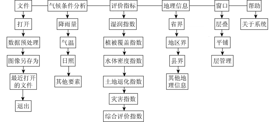
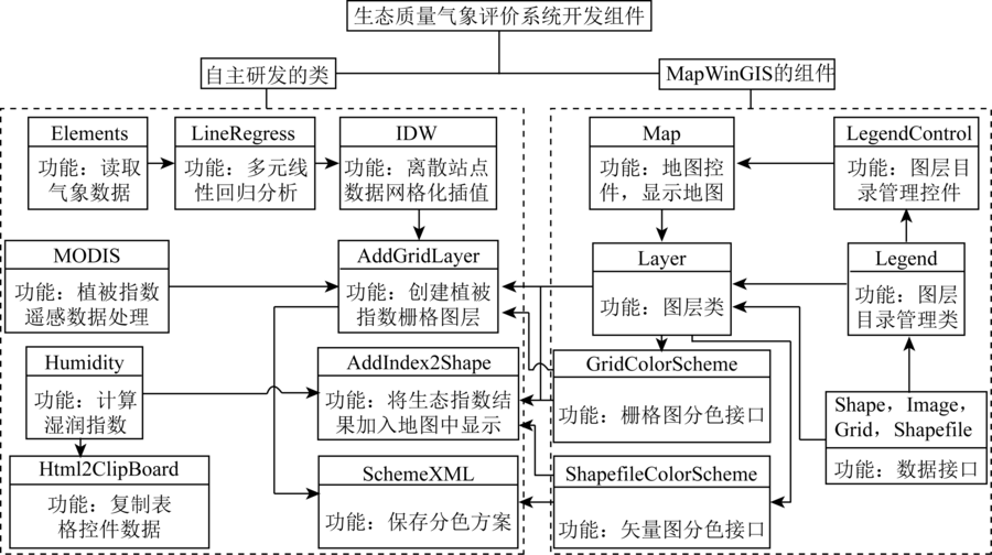
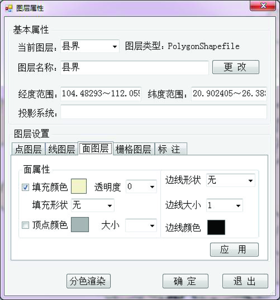
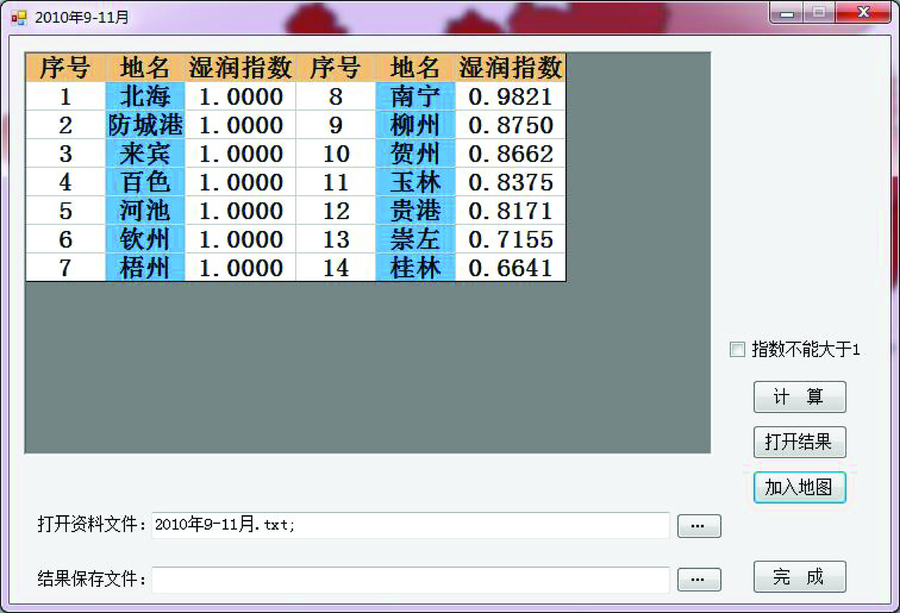
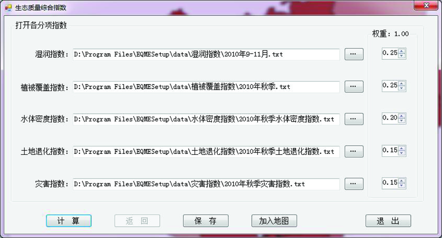
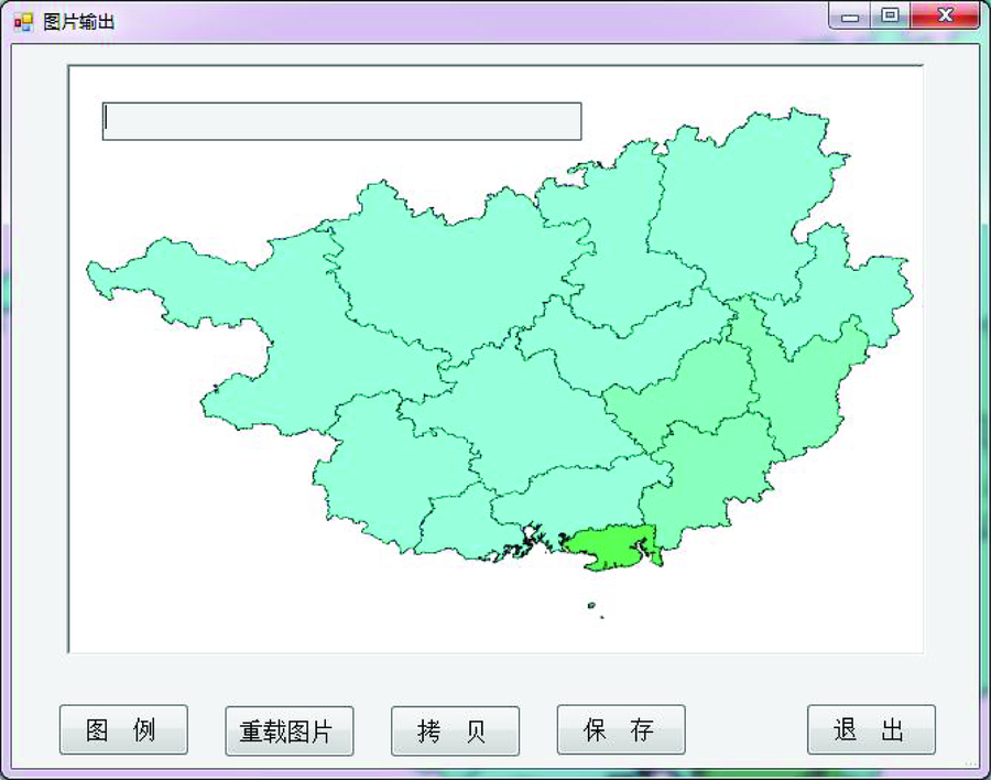
为了满足生态质量气象评价技术成果应用的需要,利用开源的地理信息系统(geographic information system,GIS)技术——MapWinGIS,在C#开发环境下,设计开发了广西生态质量气象评价业务系统。该系统从业务流程需要出发,实现了气候数据的分析处理,利用MapWinGIS的接口和类库实现了业务平台中GIS功能的设计与开发。通过自主开发编写的类,实现了包括MODIS遥感资料等气象评价数据的处理及指数计算,进而得到生态质量综合评价指标,最后利用GIS地图生成业务产品。该系统为生态质量气象评价业务工作提供了标准化的工作流程。
In order to meet the needs of the application of ecological quality meteorological evaluation technology, the authors designed a service system by using open-source GIS(MapWinGIS) technology in C# develop environment. This system has carried out the analysis and processing of climate data according to the needs of service process. By using MapWinGIS interfaces and class libraries, this platform has achieved the design and development of GIS function. And by self-developed writing class, this platform has the function of the processing of meteorological evaluation data including the MODIS remote sensing data and index calculation, finally obtaining the comprehensive evaluation index of ecological quality by using the GIS map. This system provides a standardized work flow for the ecological quality evaluation.
Wang J H, Mo W H, Chen Y L , et al. Research on meteorological evaluation of ecological quality in Guangxi based on satellite data[J]. Scientia Meteorologica Sinica, 2009,29(6):833-837.
Xiao J M . Design and Realization of Flood-Control Information Service Subsystem with Web and GIS in Heilongjiang Province[D]. Dalian: Dalian University of Technology, 2002.
Dai C L, Chi B M, Lin L , et al. Analysis and design of management information systems of groundwater monitoring based on GIS[J]. Remote Sensing Technology and Application, 2005,20(6):625-629.
[4]
王学登 . 广东省水资源管理地理信息系统[J].中国农村水利水电, 2005(11):35-36.
Wang X D . Guangdong Province water resources management geographic information system[J].China Rural Water and Hydropower, 2005(11):35-36.
Lyu G N, Li F, Shao J D. GIS construction plan of highway in Jiangsu Province,GIS construction plan of highway in Jiangsu Province (continued)[J].Transportation Science and Technology, 2000(1):18-22, 2000(2):31-33.
Cheng Y, Zhang Q, Xiong Y . A design of logistic information system based on GIS technology[J]. Journal of Hubei University of Technology, 2006,21(4):95-97.
Huang Z Y, Yuan Z T, Wan J , et al. Design of meteorological and hydrological forecasting system based on GIS in the middle reaches of Yangtze River[J]. Torrential Rain and Disasters, 2007,26(4):316-318.
Li L, Huang S Y . Design and implementation of forewarning decision system of mountain torrent base on GIS[J]. Science Technology and Engineering, 2006,6(17):2712-2715.
Sha S, Cao Y, Zhu X C . Meteorological disaster evaluation system based on GIS:Drought assessment module research[J].Science and Technology Information, 2009(23):5-6,13.
[11]
吴盛洪 . 基于GIS的气象服务监控管理平台的设计与实现[D]. 成都:电子科技大学, 2010.
Wu S H . The Design and Implementation of Meteorological Services Monitoring Management Platform based on GIS[D]. Chengdu:University of Electronic Science and Technology of China, 2010.
Dong X S, Bi S B, Guo W Z . The design and implementation of meteorology inquiry service system based on GIS[J]. Control and Automation, 2010,26(7):146-147,137.
Li X, Guo A H, Zhuang L W . The main crop diseases and pests meteorology level forecast system based on GIS[J]. Remote Sensing for Land and Resources, 2012,24(1):104-109.doi: 10.6046/gtzyyg.2012.01.19.
Xiong W B, Sun Y, Wang Y L , et al. The study of early-warning platform based GIS technology and weather Radar[J]. Remote Sensing Technology and Application, 2012,27(3):472-478.
Shi Y Q, Wu L N, Wu C F . Design and implementation of a 3D visualization and early warning system for Radar data based on GIS[J]. Remote Sensing for Land and Resources, 2013,25(1):171-175.doi: 10.6046/gtzyyg.2013.01.30.
Gao D W, Fan G F, Hu Y L , et al. 3D visualization of humidity distribution from FY-3 MWHS and its application to severe weather monitoring[J]. Remote Sensing for Land and Resources, 2014,26(1):139-143.doi: 10.6046/gtzyyg.2014.01.24.
 2018, Vol. 30
  ), 莫伟华3, 丁美花3, 王君华3, 莫建飞3