Mapping the key ecological service regions of mountains based on remote sensing and GIS
Yao LI1, Chengming YE2(), Qiang XIE3, Li LIANG1
1. Key Laboratory of Mountain Hazards and Earth Surface Processes, Institute of Mountain Hazards and Environment, Chinese Academy of Sciences, Chengdu 610041, China 2. Key Laboratory of Earth Exploration and Information Technology of Ministry of Education, Chengdu University of Technology, Chengdu 610059, China 3. Sichuan Provincial Research Academy of Environmental Protection Sciences, Chengdu 610041, China
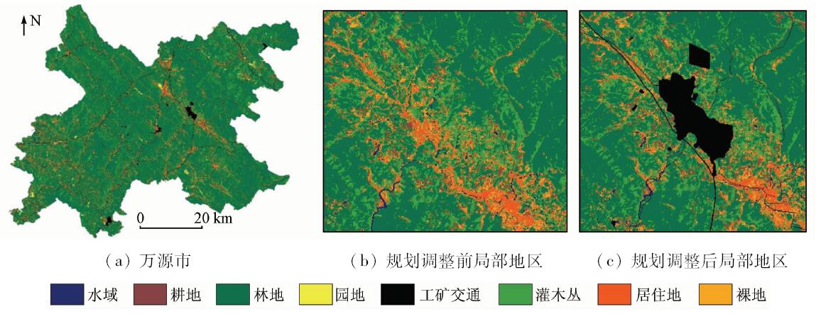
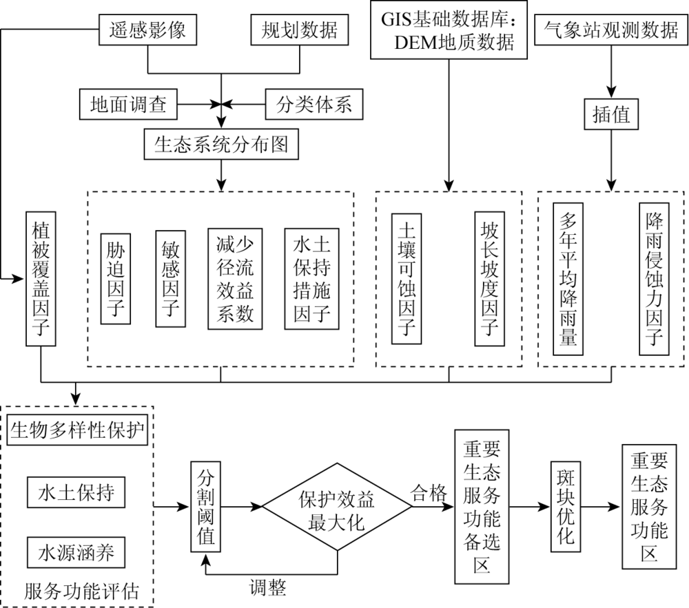
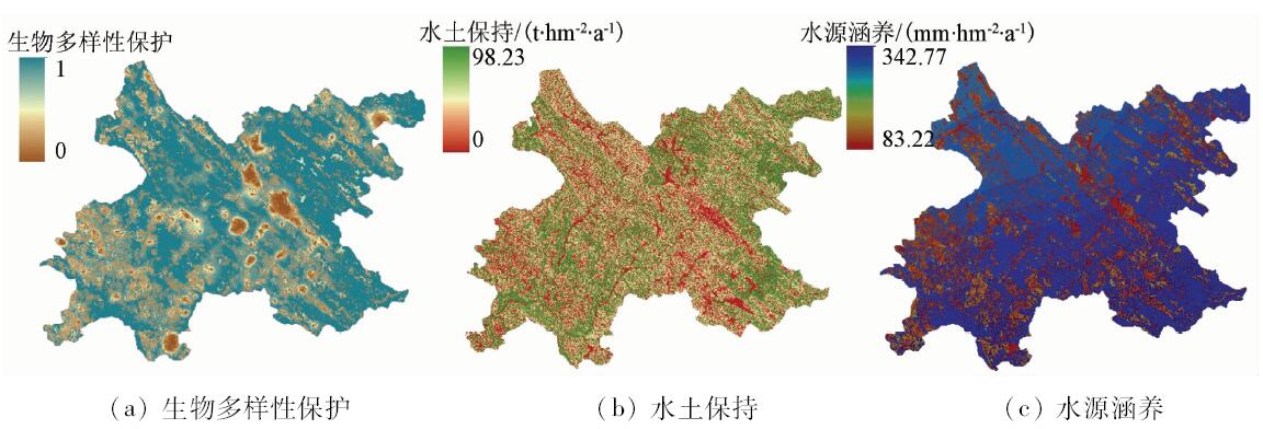
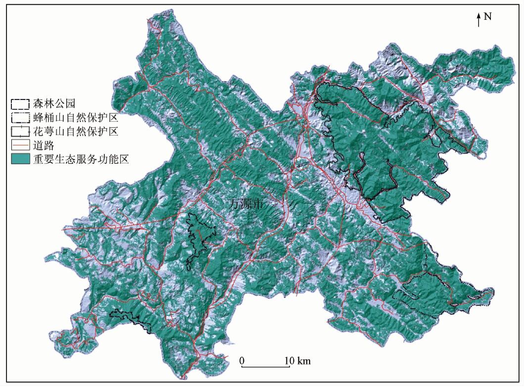
重要生态服务功能区划定与保护是社会经济可持续发展的重要基础。随着遥感(remote sensing,RS)与地理信息系统(geographic information system,GIS)技术的发展,对大区域生态环境的监测与生态服务功能快速评估技术日益成熟。提出生态保护效益计算方法,分析不同分割阈值情景下的生态保护效益系数,当得到最大生态保护效益系数时,划定重要生态服务功能区。将方法应用于典型的山地区域四川省万源市,对其进行3项生态服务功能(生物多样性保护、水土保持和水源涵养)快速评估,在归一化评估结果的基础上计算分析生态保护效益系数,最后在最优生态保护效益系数的情况下划定重要生态服务功能区。结果显示,研究区重要生态服务功能区划定面积为2 651.99 km 2,占总面积的65.4%; 其中主要集中分布在海拔高于800 m,坡度范围为[15°,35°)的区域,管理部门应加大该区域的保护力度。该方法可为山地区县级重要生态服务功能区与生态红线划定提供技术参考。
Mapping and protecting the key ecological service regions has been considered as the basis of the development of the society and economy. With the development of remote sensing (RS) and geographic information system (GIS) technology, this technique has been applied to monitoring the ecological environment and evaluating the ecological services. This paper proposes an approach to calculating the efficiency index of protection and mapping the key ecological service regions in the situation where the index is maximal. As a application, Wanyuan, the typical mountain region, was examined. The results show that the key ecological service regions cover a total area of 2 651.99 km 2, accounting for 65.4% of the study area. And it could be concluded that the key ecological service regions are distributed from steep slopes [15°,35°) where the elevation is more than 800 meters. The results suggest management to increase the efforts on protection. This paper can provide technical support for mapping the key ecological service regions of mountains.
李尧, 叶成名, 谢强, 梁莉. 基于RS和GIS的山区重要生态服务功能区划定方法[J]. 国土资源遥感, 2018, 30(4): 82-89.
Yao LI, Chengming YE, Qiang XIE, Li LIANG. Mapping the key ecological service regions of mountains based on remote sensing and GIS. Remote Sensing for Land & Resources, 2018, 30(4): 82-89.
Wilson C M, Matthews W H . Man’s Impact on the Global Environment[R].Report of the Study of Critical Environmental Problems(SCEP). 1970.
[2]
Costanza R, d’Arge R, Groot R D , et al. The value of the world’s ecosystem services and natural capital[J]. Ecological Economics, 1998,25(1):3-15.
doi: 10.1038/387253a0
Dong Q . Ecosystem services:The biological conditions and ecological supports necessary for the development of human societies[J]. Chinese Journal of Applied Ecology, 1999,10(2):106-113.
Guo Z W, Li D M, Gan Y L . The assessment of forest ecosystem biodiversity by remote sensing[J]. Acta Ecological Sinica, 2011,21(8):1369-1384.
[6]
Petrou Z I, Manakos I, Stathaki T . Remote sensing for biodiversity monitoring:A review of methods for biodiversity indicator extraction and assessment of progress towards international targets[J]. Biodiversity and Conservation, 2015,24(10):2333-2363.
doi: 10.1007/s10531-015-0947-z
[7]
Coops N C, Fontana F M A, Harvey G K A, et al. Monitoring of a national-scale indirect indicator of biodiversity using a long time-series of remotely sensed imagery[J]. Canadian Journal of Remote Sensing, 2014,40(3):179-191.
doi: 10.1080/07038992.2014.945826
Li W H, Zhang B, Xie G D . Research on ecosystem services in China:Progress and perspectives[J]. Journal of Naturel Resources, 2009,24(1):1-10.
[9]
Alexakis D D, Hadjimitsis D G, Agapiou A . Integrated use of remote sensing,GIS and precipitation data for the assessment of soil erosion rate in the catchment area of“Yialias” in Cyprus[J]. Atmospheric Research, 2013,131(2):108-124.
doi: 10.1016/j.atmosres.2013.02.013
[10]
Eckert S, Ghebremicael S T, Hurni H , et al. Identification and classification of structural soil conservation measures based on very high resolution stereo satellite data[J]. Journal of Environmental Management, 2017,193:592-606.
doi: 10.1016/j.jenvman.2017.02.061
pmid: 28262422
Li W J, Zhang S H, Wang H M . Ecosystem services evaluation based on geographic information system and remote sensing technology:A review[J]. Chinese Journal of Applied Ecology, 2011,22(12):3358-3364.
[12]
Krois J, Schulte A . GIS-based multi-criteria evaluation to identify potential sites for soil and water conservation techniques in the Ronquillo watershed, northern Peru[J]. Applied Geography, 2014,51:131-142.
doi: 10.1016/j.apgeog.2014.04.006
Xiang B, Ren H L, Ma G W , et al. Assessment of ecosystem service importance in Cheng-Yu economic zone[J]. Research of Environmental Sciences, 2011,24(7):722-730.
Li Y C, Liu C X, Min J , et al. RS /GIS-based integrated evaluation of the ecosystem services of the Three Gorges Reservoir area (Chongqing section)[J]. Acta Ecologica Sinica, 2013,33(1):168-178.
[15]
国家环境保护部. 生态保护红线划定技术指南[M]. 北京:国家环境保护部, 2017.
Ministry of Environmental Protection of the People’s Republic of China. Ecological Red Line Technology Guide[M]. Beijing:Ministry of Environment Protection of the People’s Republic of China, 2017.
Ouyang Z Y, Zhang L, Wu B F , et al. An ecosystem classification system based on remote sensor information in China[J]. Acta Ecologica Sinica, 2015,35(2):219-226.
Sun C Z, Zhen L, Wang C , et al. Biodiversity simulation of Poyang Lake wetlands by invest model under different scenarios[J]. Resources and Environment in the Yangtze Basin, 2015,24(7):1119-1125.
[19]
Tallis H T, Ricketts T, Guerry A D , et al. InVEST 2.5.6 User’s Guide[Z]. Stanford:The Natural Capital Project, 2013.
[20]
Polasky S, Nelson E, Pennington D , et al. The impact of land use change on ecosystem services,biodiversity and returns to landowners:A case study in the State of Minnesota[J]. Environmental and Resource Economics, 2014,48(2):219-242.
doi: 10.1007/s10640-010-9407-0
[21]
Abdo H, Salloum J . Mapping the soil loss in Marqya basin:Syria using RUSLE model in GIS and RS techniques[J]. Environmental Earth Sciences, 2017,76(3):114.
doi: 10.1007/s12665-017-6424-0
Yang R R, Xu H Q, Lin N , et al. RUSLE-based quantitative study on the soil erosion of the Hetian Basin area in Changting County,Fujian Province,China[J]. Acta Ecologica Sinica, 2013,33(10):2974-2982.
Wu C G, Li S, Ren H D , et al. Quantitative estimation of vegetation cover and management factor in USLE and RUSLE models by using remote sensing data:A review[J]. Chinese Journal of Applied Ecology, 2012,23(6):1728-1732.
Song C F, Tao H P, Liu B T , et al. Spatial distribution characteristics of soil erodibility K value in the upper Yangtze River[J]. Resources and Environment in the Yangtze Basin, 2012,21(9):1123-1130.
Zhang H M, Yang Q K, Liu Q R , et al. Regional slope length and slope steepness factor extraction algorithm based on GIS[J]. Computer Engineering, 2010,36(9):246-248.
Zhang B, Li W H, Xie G D , et al. Water conservation function and its measurement methods of forest ecosystem[J]. Chinese Journal of Ecology, 2009,28(3):529-534.
He Y H, Chen X H, Lin K R , et al. Temporal and spatial characteristics of runoff coefficient variations in the Dongjiang Basin during 1964—2012[J]. Geographical Research, 2014,33(6):1049-1058.
 2018, Vol. 30
  ), 谢强3, 梁莉1