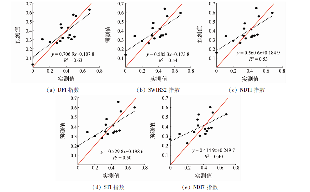
Non-photosynthetic vegetation (NPV) is an important component of grassland ecosystem, which affects the flow and cycle of carbon, water and energy in the ecosystem. It is of great significance to quantitatively grasp the fractional cover of non-photosynthetic vegetation (fNPV) information for the scientific and effective utilization of grassland resources and the protection of the ecological environment. Taking the typical steppe of Xilingol in Inner Mongolia as the research area and using the regression analysis method, the authors used a variety of non-photosynthetic vegetation indices (NPVIs) based on MODIS (MCD43A4) data and field measured fNPV data to invert the fNPV model and evaluated the estimation effect of the model. The results show that the NPVIs based on MODIS data have a good correlation with fNPV. The correlations are as follows: DFI, SWIR32, NDTI, STI, NDI7, NDI5 and NDSVI. The DFI index inversion fNPV model has higher estimation accuracy. It can be applied to the rapid monitoring of large scale fNPV in typical steppe.
柴国奇, 王静璞, 王光镇, 韩柳, 王周龙. 基于MODIS数据的典型草原非光合植被覆盖度估算[J]. 国土资源遥感, 2019, 31(3): 234-241.
Guoqi CHAI, Jingpu WANG, Guangzhen WANG, Liu HAN, Zhoulong WANG. Estimation of fractional cover of non-photosynthetic vegetation in typical steppe based on MODIS data. Remote Sensing for Land & Resources, 2019, 31(3): 234-241.
Ren H R, Zhou G S, Zhang F , et al. Evaluating cellulose absorption index (CAI) for non-photosynthetic biomass estimation in the desert steppe of Inner Mongolia[J]. China Science Bulletin, 2012,57(10):839-845.
[2]
Guerschman J P, Hill M J, Renzullo L J , et al. Estimating fractional cover of photosynthetic vegetation,non-photosynthetic vegetation and bare soil in the Australian tropical savanna region upscaling the EO-1 Hyperion and MODIS sensors[J]. Remote Sensing of Environment, 2009,113(5):928-945.
[3]
Daughtry C S T, Hunt E R, Doraiswamy P C , et al. Remote sensing the spatial distribution of crop residues[J]. Agronomy Journal, 2005,97(3):864-874.
[4]
Daughtry C S T, Doraiswamy P C, Hunt E R , et al. Remote sensing of crop residue cover and soil tillage intensity[J]. Soil and Tillage Research, 2006,91(1-2):101-108.
[5]
Daughtry C S T, Hunt E R, McMurtrey J E . Assessing crop residue cover using shortwave infrared reflectance[J]. Remote Sensing of Environment, 2004,90(1):126-134.
[6]
Daughtry C S T . Discriminating crop residues from soil by shortwave infrared reflectance[J]. Agronomy Journal, 2001,93(1):125-131.
[7]
Henry H A L, Brizgys K, Field C B . Litter decomposition in a California annual grassland:Interactions between photodegradation and litter layer thickness[J]. Ecosystems, 2008,11(4):545-554.
[8]
Nagler P L, Inoue Y, Glenn E P , et al. Cellulose absorption index (CAI) to quantify mixed soil-plant litter scenes[J]. Remote Sensing of Environment, 2003,87(2-3):310-325.
[9]
Elmore A J, Asner G P, Hughes R F . Satellite monitoring of vegetation phenology and fire fuel conditions in Hawaiian drylands[J]. Earth Interactions, 2005,9(21):1-21.
[10]
Mcnairn H, Protz R . Mapping corn residue cover on agricultural fields in Oxford County,Ontario,using thematic mapper[J]. Canadian Journal of Remote Sensing, 1993,19(2):152-159.
[11]
Cao X, Chen J, Matsushita B , et al. Developing a MODIS-based index to discriminate dead fuel from photosynthetic vegetation and soil background in the Asian steppe area[J]. International Journal of Remote Sensing, 2010,31(6):1589-1604.
Li T, Li X S, Li F . Estimating fractional cover of photosynthetic vegetation and non-photosynthetic vegetation in the Xilingol steppe region with EO-1 Hyperion data[J]. Acta Ecologica Sinica, 2015,35(11):3643-3652.
Ji C C, Jia Y H, Li X S , et al. Research on linear and nonlinear spectral mixture models for estimating vegetation fractional cover of nitraria bushes[J]. Journal of Remote Sensing, 2016,20(6):1402-1412.
Li Z T, Wang C K, Pan X Z , et al. Estimation of wheat residue cover using simulated Landsat-8 OLI datas[J]. Transactions of the Chinese Society of Agricultural Engineering, 2016,32(s1):145-152.
Wang G Z, Wang J P, Zou X Y , et al. Estimation of fractional cover of photosynthetic and non-photosynthetic vegetation in the Xilingol steppe region using the NDVI-DFI model[J]. Acta Ecologica Sinica, 2017,37(17):5722-5731.
[16]
Li X, Zheng G, Wang J , et al. Comparison of methods for estimating fractional cover of photosynthetic and non-photosynthetic vegetation in the Otindag Sandy Land using GF-1 wide-field view data[J]. Remote Sensing, 2016,8(10):800.
Wang G Z, Wang J P, Zou X Y , et al. A review on estimating fractional cover of non-photosynthetic vegetation by using remote sensing[J]. Remote Sensing Technology and Application, 2018,33(1):1-9.
Zhang M, Li Q Z, Meng J H , et al. Review of crop residue fractional cover monitoring with remote sensing[J]. Spectroscopy and Spectral Analysis, 2011,31(12):3200-3205.
[19]
Jacques D C, Kergoat L, Hiernaux P , et al. Monitoring dry vegetation masses in semi-arid areas with MODIS SWIR bands[J]. Remote Sensing of Environment, 2014,153:40-49.
[20]
van Deventer A P, Ward A D, Gowda P H , et al. Using thematic mapper data to identify contrasting soil plains and tillage practices[J]. Photogrammetric Engineering and Remote Sensing, 1997,63(1):87-93.
[21]
Qi J, Marsett R, Heilman P , et al. RANGES improves satellite-based information and land cover assessments in southwest United States[J]. EOS Transactions American Geophysical Union, 2002,83(51):601-606.
Liu C J, Zhang L, Zhou Y , et al. Retrieval and analysis of grassland coverage in arid Xinjiang,China and five countries of Central Asia[J]. Pratacultural Science, 2016,33(5):861-870.
Zhang H B, Li J S, Xiang N P , et al. A study of extracting water bodies automatically based on the MODIS surface reflectance data[J]. Remote Sensing Technology and Application, 2015,30(6):1160-1167.
[25]
Serbin G , Daughtry C S T,Hunt E R ,et al. Effects of soil composition and mineralogy on remote sensing of crop residue cover[J]. Remote Sensing of Environment, 2009,113(1):224-238.
Tang S H, Zhu Q J, Sun R . The inversion algorithm and its validation of coarse scale leaf area index based on the direction of the reflectivity[J]. Progress in Natural Science, 2006,16(3):331-337.
Sun C X, Liu L Y, Guan L L , et al. Validation and error analysis of the MODIS LAI product in Xilinhot grassland[J]. Journal of Remote Sensing, 2014,18(3):518-536.
Yu H, Wu Y F, Jin Y , et al. An approach for monitoring the aboveground biomass of grassland in arid areas based on MODIS SWIR bands[J]. Remote Sensing Technology and Application, 2017,32(3):524-530.
[29]
Gelder B K, Kaleita A L, Cruse R M . Estimating mean field residue cover on midwestern soils using satellite imagery[J]. Agronomy Journal, 2009,101(3):635-643.
[30]
Cao X, Cui X, Yue M , et al. Evaluation of wildfire propagation susceptibility in grasslands using burned areas and multivariate logistic regression[J]. International Journal of Remote Sensing, 2013,34(19):6679-6700.
[31]
Ren H, Zhou G . Estimating senesced biomass of desert steppe in Inner Mongolia using field spectrometric data[J]. Agricultural and Forest Meteorology, 2012,161(4):66-71.
Xie X Y, Liu Y M, Li J Z , et al. Remote sensing estimation of plant litter cover based on the spectra of plant litter-soil mixed scenes[J]. Spectroscopy and Spectral Analysis, 2016,36(7):2217-2223.
 2019, Vol. 31
  ), 王光镇, 韩柳, 王周龙