Analyzing spatio-temporal changes in the shoreline morphology of Xiamen City in the context of urbanization
LIU Yuan1(), LI Ting1,2
1. School of Architecture and Art Design, Hunan University of Science and Technology,Xiangtan 411100, China 2. School of Resource & Environment and Safety Engineering, Hunan University of Science and Technology,Xiangtan 411100,China
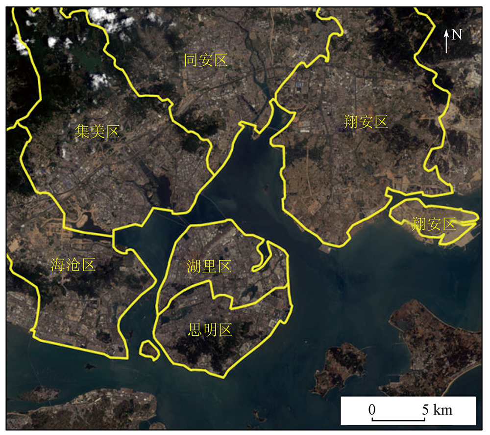
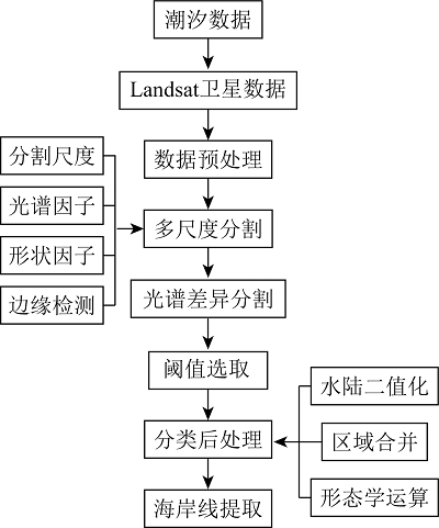
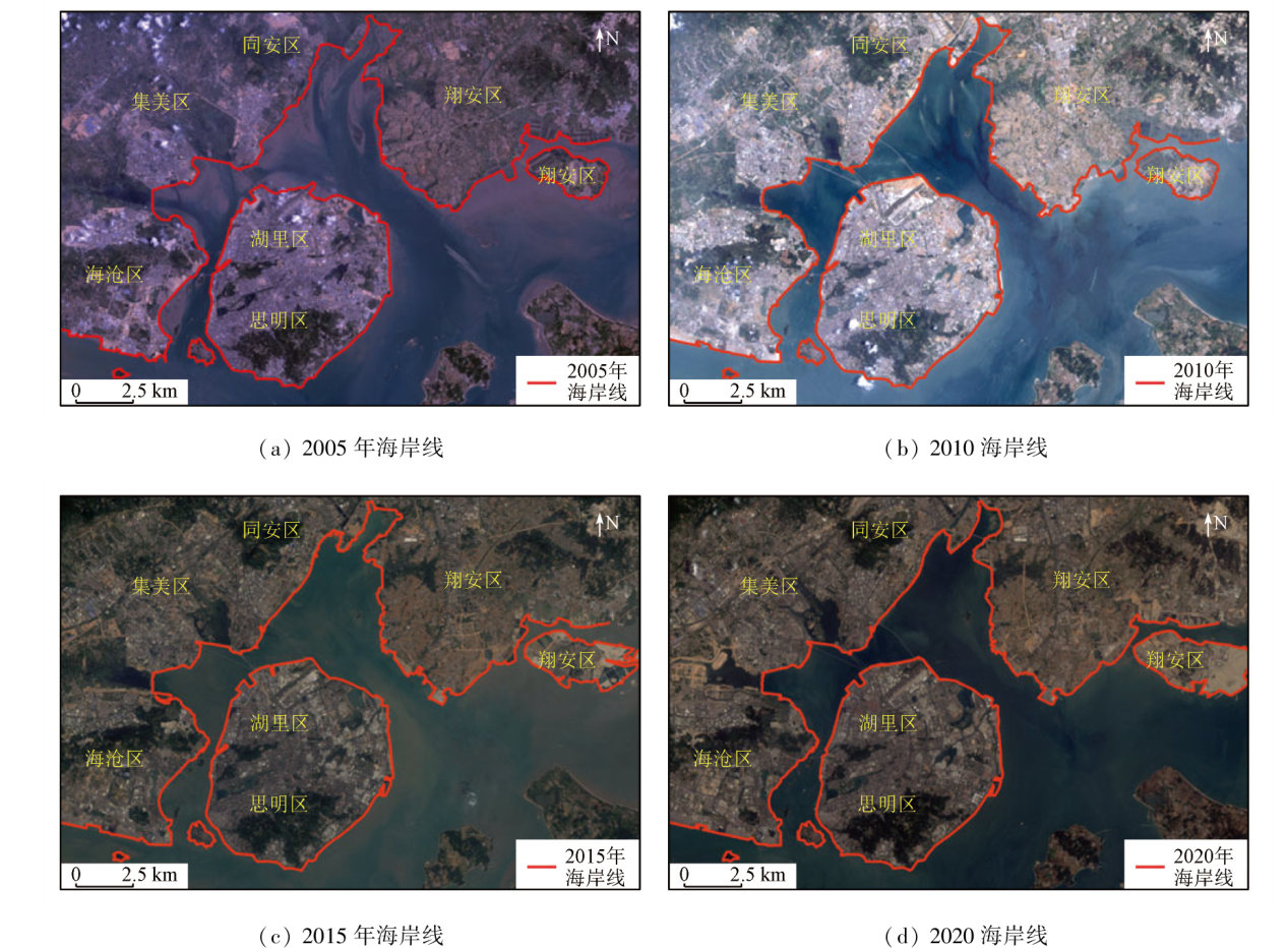
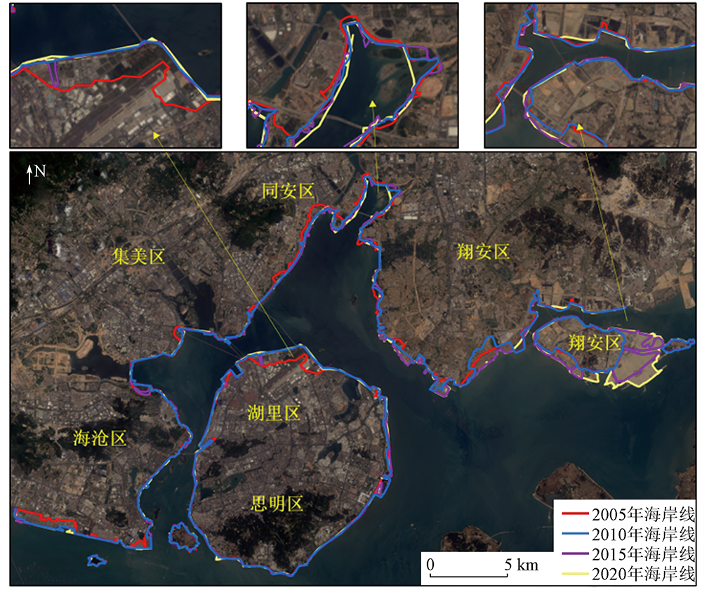
China boasts long shorelines and abundant marine resources. Xiamen, a coastal city in China, has seen significant changes in its shorelines in recent years due to an increase in activities including port construction, coastal industry, and coastal tourism development. Hence, efficiently and accurately determining the spatio-temporal changes in Xiamen's shoreline holds critical research value and practical significance. This study extracted information on the shorelines from the Landsat remote sensing images in 2005, 2010, 2015, and 2020 using the object-oriented method. Then, it delved into the spatio-temporal evolution of shoreline length, shoreline morphology, and land area changes. The results reveal significant spatio-temporal changes in Xiamen’s shoreline over the 15 years. The shoreline length changed quickly and then moderately, peaking from 2010 to 2015, with an average rate as high as 4.1 km/a, primarily in the vicinity of Dadeng Island and Haixiang Pier. The shoreline morphology tended to be flattened year by year, with the most pronounced changes observed in Huli District. From 2005 to 2020, the land area of Xiamen increased approximately 24.5 km2, with the most significant increase occurring in Xiang’an District. The changes in the shoreline were influenced by many factors, predominantly including population growth, economic development, and the introduction and change of policies.
刘源, 李婷. 城市化进程下厦门市海岸线形态时空变化分析[J]. 自然资源遥感, 2024, 36(1): 267-274.
LIU Yuan, LI Ting. Analyzing spatio-temporal changes in the shoreline morphology of Xiamen City in the context of urbanization. Remote Sensing for Natural Resources, 2024, 36(1): 267-274.
Liu B Q, Meng W Q, Zhao J H, et al. Variation of coastline resources utilization in China from 1990 to 2013[J]. Journal of Natural Resources, 2015, 30(12):2033-2044.
[3]
Solomon S M. Spatial and temporal variability of shoreline change in the Beaufort-Mackenzie region,Northwest Territories,Canada[J]. Geo-Marine Letters, 2005, 25(2):127-137.
doi: 10.1007/s00367-004-0194-x
[4]
Yu K, Hu C, Muller-Karger F E, et al. Shoreline changes in west-central Florida between 1987 and 2008 from Landsat observations[J]. International Journal of Remote Sensing, 2011, 32(23):8299-8313.
doi: 10.1080/01431161.2010.535045
[5]
Sagar S, Roberts D, Bala B, et al. Extracting the intertidal extent and topography of the Australian coastline from a 28 year time series of Landsat observations[J]. Remote Sensing of Environment, 2017, 195:153-169.
doi: 10.1016/j.rse.2017.04.009
Zhu J F, Wang G M, Zhang J L, et al. Remote sensing investigation and recent evolution analysis of Pearl River delta coastline[J]. Remote Sensing for Land and Resources Resources, 2013, 25(3):130-137.doi:10.6046/gtzyyg.2013.03.22.
Wang Z J, Zhang Y, Chen L F, et al. Methods for extracting the information of coastal accretion-erosion variations from high-resolution satellite images[J]. Advances in Marine Science, 2012, 30(1):63-68.
[8]
张汉女. 基于SVM的海岸线提取方法研究[D]. 长春: 东北师范大学, 2010.
Zhang H N. Coastline extraction using support vector machine from remote sensing image[D]. Changchun: Northeast Normal University, 2010.
Huang H J, Li C Z, Guo J J. Application of landsat images to the studies of the shoreline changes of the Huanghe River delta[J]. Marine Geology & Quaternary Geology, 1994, 14(2):29-37.
Ye X M, Ding J, Xu Y, et al. On the changes of the coastline in Bohai Bay during the last 30 years[J]. Ocean Development and Management, 2016, 33(2):56-62.
Yang J Z, Li Z Z, Zhao Y L. The remote sensing dynamic monitoring of Hangzhouwan banks[J]. Remote Sensing for Land and Resources, 2002, 14(1):23-28.doi:10.6046/gtzyyg.2002.01.06.
Zhou L Y, Zhang Z X, Lu K. Shoreline change and reclaimation of silty coast in Jiangsu Province during 1985—2002[J]. Marine Geology Letters, 2010, 26(6):7-11.
Chen X Y, Zhang J, Ma Y. Analysis of the spatial and temporal changes of the coastline in the Haizhou Bay during the past 40 years[J]. Advances in Marine Science, 2014, 32(3):324-334.
Lin S, Yu X J, Zhuang X B, et al. Fractal characteristics evolution of coastline of the Xiamen Island[J]. Advances in Marine Science, 2020, 38(1): 121-129.
Wu Y Q, Liu Z L. Research progress on methods of automatic coastline extraction based on remote sensing images[J]. Journal of Remote Sensing, 2019, 23(4):582-602.
Liang L, Liu Q S, Liu G H, et al. Review of coastline extraction methods based on remote sensing images[J]. Journal of Geo-information Science, 2018, 20(12):1745-1755.
Hou X Y, Wu T, Hou W, et al. Characteristics of coastline changes in mainland Chinese mainland since the early 1940s[J]. Scientia Sinica(Terrae), 2016, 46(8):1065-1075.
Li X, Zhang L P, Ji C C, et al. Spatiotemporal changes of Jiangsu coastline: A remote sensing and GIS approach[J]. Geographical Research, 2014, 33(3):414-426.
[21]
陈绍炯. 厦门港口与城市经济互动发展研究[D]. 厦门: 集美大学, 2016.
Chen S J. Research on interactive development of Xiamen port and economy[D]. Xiamen: Jimei University, 2016.
Li J L, Wang L J. Spatial and temporal evolutions of the major bays in the East China Sea under the influence of reclamation[J]. Acta Geographica Sinica, 2020, 75(1):126-142.
doi: 10.11821/dlxb202001010
 2024, Vol. 36
  ), 李婷1,2