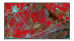
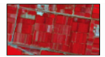
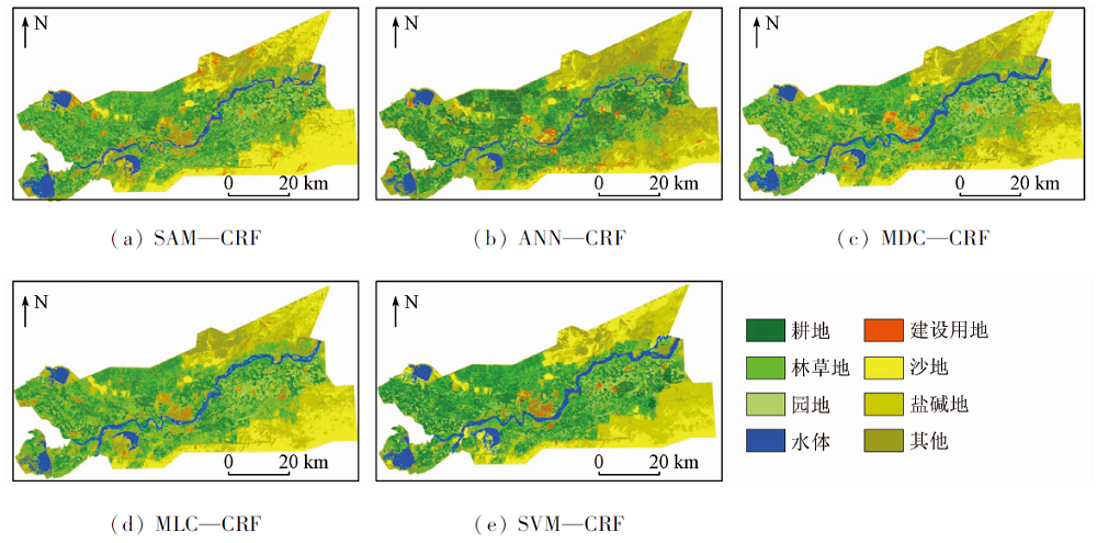
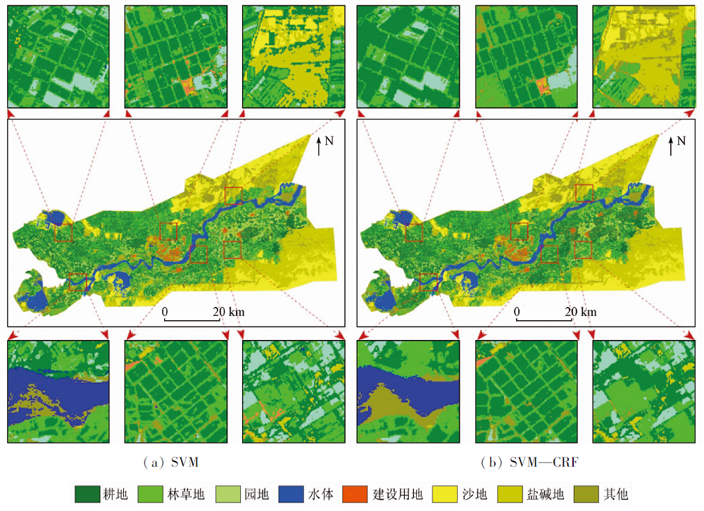
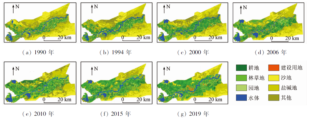
The clarification of the dynamic change trend of cultivated land and its driving factors is an important basis for ensuring national food security, rationally developing and utilizing soil and water resources and adjusting land use structure. Taking Alar reclamation area in southern Xinjiang as an example and based on Landsat satellite remote sensing images, population, GDP and other data of seven important periods from 1990 to 2019, the authors selected the best algorithm to interpret remote sensing images by comparing the accuracy of five classification algorithms comprising SAM-CRF, ANN-CRF, MDC-CRF, MLC-CRF and SVM-CRF. Next, the characteristics of cultivated land area change, type transformation and spatial dynamic change were analyzed by using the interpretation results, and then the main driving factors, action path and intensity of cultivated land area change were discussed. The results show that the SVM-CRF algorithm has the highest classification accuracy among the five classification algorithms, with the overall accuracy of 0.95 and the Kappa coefficient of 0.94. The overall accuracy of the other four algorithms is between 0.65 and 0.89, and the Kappa coefficient is between 0.58 and 0.86. The area of cultivated land in the study area has continued to increase in the past three decades, and the net increase in cultivated land area is 729.97 km 2 (312.21%). Cultivated land transfer-in and transfer-out has shown a trend of outward expansion and inward contraction, respectively. Total population, GDP, Total Investment in Fixed Assets, gross agricultural product and cotton price are the main driving factors for the change of cultivated land area,among which GDP has the greatest direct impact on the change of cultivated land area, while cotton price has the least impact. Except that GDP has a negative effect on cultivated land area, the other four factors have a positive effect on cultivated land area, and the overall performance of the five factors is a positive effect.
宋奇, 冯春晖, 高琪, 王明玥, 吴家林, 彭杰. 阿拉尔垦区近30年耕地变化及其驱动因子分析[J]. 国土资源遥感, 2021, 33(2): 202-212.
SONG Qi, FENG Chunhui, GAO Qi, WANG Mingyue, WU Jialin, PENG Jie. Change of cultivated land and its driving factors in Alar reclamation area in the past thirty years. Remote Sensing for Land & Resources, 2021, 33(2): 202-212.
Zhao X L, Zhang Z X, Wang X, et al. Analysis of chinese cultivated land’s spatial-temporal changes and causes in recent 30 years[J]. Transactions of the Chinese Society of Agricultural Engineering, 2014, 30(3):1-11.
[2]
Wang Y H, Dai E F, Yin L, et al. Land use/land cover change and the effects on ecosystem services in the Hengduan mountain region,China[J]. Ecosystem Services, 2018, 34(A):55-67.
doi: 10.1016/j.ecoser.2018.09.008
[3]
Wang J, Chen Y Q, Shao X M, et al. Land-use changes and policy dimension driving forces in China:Present,trend and future[J]. Land Use Policy, 2012, 29(4):737-749.
doi: 10.1016/j.landusepol.2011.11.010
Chen H, Wu S X, Feng X L. Study on the changes of cultivated Land and the driving factors in Xinjiang based on RS and GIS[J]. Journal of Natural Resources, 2010, 25(4):614-624.
Li J G, He C Y, Shi P J, et al. Change process of cultivated land and its driving forces in northern China during 1983—2001[J]. Acta Geographica Sinica, 2004, 59(2):274-282.
Yang G S. Land use and land cover change and regional economic development:The revelation of the change in cropland area in the Yangtze river delta during the past 50 years[J]. Acta Geographica Sinica, 2004, 59(s1):41-46.
[7]
Jia B Q, Zhang Z Q, Ci L G, et al. Oasis land-use dynamics and its influence on the oasis environment in Xinjiang,China[J]. Journal of Arid Environments, 2004, 56(1):11-26.
doi: 10.1016/S0140-1963(03)00002-8
[8]
Wang X C, Dong X B, Liu H M, et al. Linking land use change,ecosystem services and human well-being:A case study of the Manas River Basin of Xinjiang,China[J]. Ecosystem Services, 2017, 27(A):113-123.
doi: 10.1016/j.ecoser.2017.08.013
Yu S S, Sun Z C, Guo H D, et al. Monitoring and analyzing the spatial dynamics and patterns of megacities along the Maritime Silk Road[J]. Journal of Remote Sensing, 2017, 21(2):169-181.
[10]
蔡利华. 阿拉尔垦区耕地养分现状与分布特征[D]. 石河子:石河子大学, 2013.
Cai L H. The status and spatial distribution of soil nutrient in Alar reclamation area[D]. Shihezi:Shihezi University, 2013.
Zhang Y B, Yan H J. Effect of natural disaster on agricultural economy in Alar irrigated area[J]. Mathematics in Practice and Theory, 2017, 47(1):286-290.
Zhu J F, Zhou Y, Wang S X, et al. Analysis of changes of Baiyangdian wetland from 1975 to 2018 based on remote sensing[J]. Journal of Remote Sensing, 2019, 23(5):971-986.
Liang L, Yang M H, Li Y F. Hyperspectral remote sensing image classification based on ICA and SVM algorithm[J]. Spectroscopy and Spectral Analysis, 2010, 30(10):2724-2728.
Yuan J W, Wu C, Du B, et al. Analysis of landscape pattern on urban land use based on GF-5 hyperspectral data[J]. Journal of Remote Sensing(Chinese), 2020, 24(4):465-478.
[15]
Gong J Z, Jiang C, Chen W L, et al. Spatiotemporal dynamics in the cultivated and built-up land of Guangzhou:Insights from zoning[J]. Habitat International, 2018, 82:104-112.
doi: 10.1016/j.habitatint.2018.10.004
[16]
Liu C H, Ma X X. Analysis to driving forces of land use change in Lu’an mining area[J]. Transactions of Nonferrous Metals Society of China, 2011, 21(3):727-732.
[17]
Elagouz M H, Abou-Shleel S M, Belal A A, et al. Detection of land use/cover change in egyptian nile delta using remote sensing[J]. The Egyptian Journal of Remote Sensing and Space Sciences, 2020, 23(1):57-62.
[18]
Shen S G, Yue P, Fan C J. Quantitative assessment of land use dynamic variation using remote sensing data and landscape pattern in the Yangtze river delta,China[J]. Sustainable Computing:Informatics and Systems, 2019, 23:111-119.
doi: 10.1016/j.suscom.2019.07.006
Song G, Wang Y, Lei G P. Effect mechanism research of influential factors of cultivated land use system security of black soil region in songnen high plain:A case study of Bayan County in Heilongjiang Province[J]. Journal of Natural Resources, 2014, 29(1):13-26.
[20]
Tian G J, Liu J Y, Xie Y C, et al. Analysis of spatio-temporal dynamic pattern and driving forces of urban land in China in 1990s using TM images and GIS[J]. Cities, 2005, 22(6):400-410.
doi: 10.1016/j.cities.2005.05.009
[21]
Fan Q D, Ding S Y. Landscape pattern changes at a county scale:A case study in Fengqiu,Henan Province,China from 1990 to 2013[J]. Catena, 2016, 137:152-160.
doi: 10.1016/j.catena.2015.09.012
[22]
Liu Y L, Luo T, Liu Z Q, et al. A comparative analysis of urban and rural construction land use change and driving forces:implications for urbanerural coordination development in Wuhan,Central China[J]. Habitat International, 2015, 47:113-125.
doi: 10.1016/j.habitatint.2015.01.012
 2021, Vol. 33
  ), 冯春晖, 高琪, 王明玥, 吴家林, 彭杰(