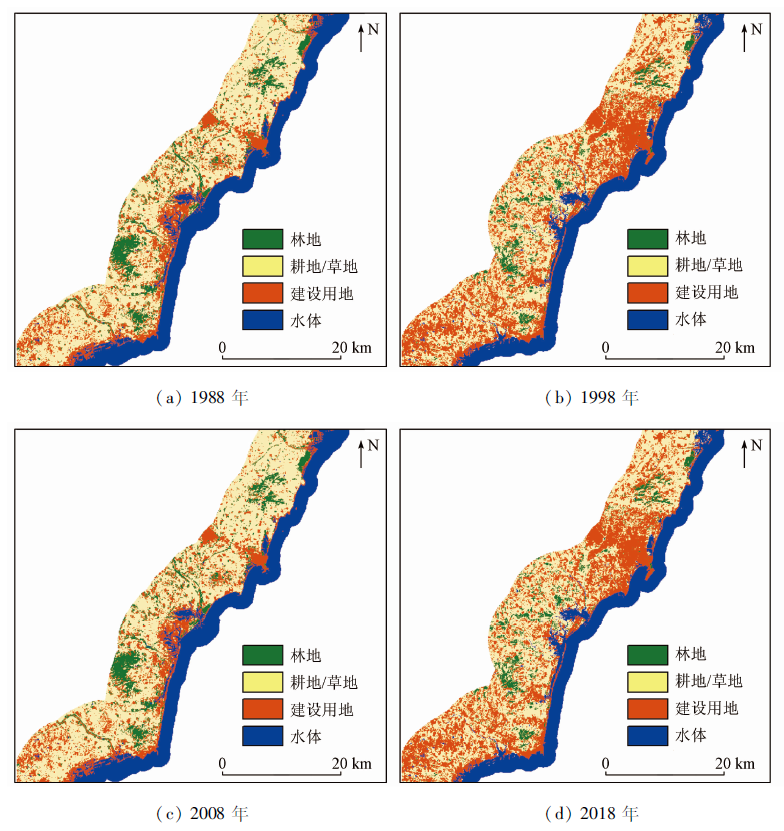
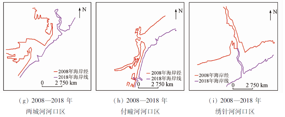
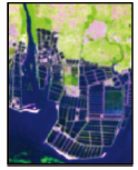
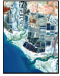
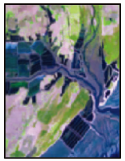
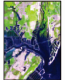
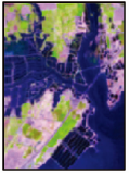
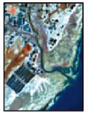
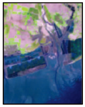
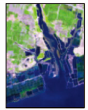
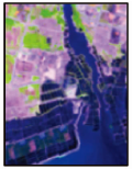
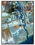
With the implementation of the National Marine Strategy and the deepening of coastal zone development in coastal areas, it is necessary to study the coastal zone evolution as well as monitor and protect the coastal zone, which will provide a reasonable basis for coastal zone development. In this paper, remote sensing (RS) and (geographic information system, GIS) technology, Landsat, (digital elevation model, DEM) and tidal data were used to extract coastal zone data of Rizhao City in 1988, 1998, 2008 and 2018, and analyze the coastline distribution characteristics, the spatio-temporal distribution and land use status of coastal zone and dynamic evolution of estuary. The results are as follows: Firstly, the coastline of Rizhao showed an overall growth trend from 1988 to 2018, with a total increase of 52.7 km; The period of 1998—2008 experienced the fastest coastline growing, with the growth rate being 0.68 km/a. The distribution of coastline was dominated by sandy coastline and artificial coastline. Secondly, the land use change in the coastal zone was manifested in the continuous increase of the construction land area, with its proportion from 213.77 km2 to 413.93 km2, while the farmland/grassland area and its proportion decreased from 445.50 km2 to 287.03 km2. The overall trend was that a large amount of cultivated land/grassland was converted to construction land. Thirdly, the estuary was a place where the change of coastal erosion and deposition was the most prominent. The estuary was eroded and the estuarine shoreline retreated from 1988 to 1998. The estuary remained relatively stable from 1998 to 2008. The estuary silted up to the sea and the coastline grew seaward from 2008 to 2018. In general, changes in the landward direction of the coastal zone are affected by geomorphic types, sea level rise, sediment discharge, artificial sand mining and some other factors. Changes in the seaward direction are related to sediment accumulation, establishment of breeding areas and ports, reclamation and other coastal development activities. The conclusion of this paper can provide reference for the planning and management of Rizhao coastal zone.
苗苗, 谢小平. 基于GIS和RS的山东日照海岸带1988—2018年间演化分析[J]. 国土资源遥感, 2021, 33(2): 237-247.
MIAO Miao, XIE Xiaoping. Spatial-temporal evolution analysis of Rizhao coastal zone during 1988—2018 based on GIS and RS. Remote Sensing for Land & Resources, 2021, 33(2): 237-247.
Wang Y X, Gan Y Q, Deng Y M, et al. Land-ocean interactions and their eco-environmental effects in the coastal zone:Current progress and future perspectives[J]. Bulletin of Geological Science and Technology, 2020, 39(1):1-9.
Wu W J, Chen J Y, Ye R Y, et al. Vulnerability assessment of urban socio-ecological systems in coastal zones under the influence of typhoons:Big data perspective[J]. Acta Ecologica Sinica, 2019, 39(19):7079-7086.
Liu X Y. A review of the researches on storm surge disasters along Shandong coast since China’s reform and opening up[J]. Journal of Institute of Disaster Prevention, 2020, 22(1):72-79.
[7]
赵琪琪. 我国沿海主要海洋灾害类型及其影响分析[D]. 烟台:鲁东大学, 2018.
Zhao Q Q. The study on coastal major hazards and their impact analysis on the coast of China[D]. Yantai:Ludong University, 2018.
Yao X J, Gao Y, Du Y Y, et al. Spatial and temporal changes of hainan coastline in the past 30 years based on RS[J]. Journal of Natural Resources, 2013, 28(1):114-124.
Chen J Y. Changes and driving factors of coastline in the Pearl River delta in recent 40 years based on GIS and RS[D]. Chengdu:Sichuan Normal University, 2017.
Kang B, Lin N, Xu W B, et al. Spatial-temporal changes of the coastline in five south island of Long Island in recent three decades on RS and GIS[J]. Marine Science Bulletin, 2017, 36(5):585-593.
Liu Y H, Liu P Y, Bu F S, et al. Remote sensing monitoring of coastline changes in Rizhao City during the past 30 years[J]. Journal of Green Science and Technology, 2018,(6):139-141.
Xu W Y, Xie X P, Chen Z C, et al. The analysis of dynamic evolution on coastal landscape patterns based on the satellite images in Rizhao City,Shandong Province[J]. Journal of Qufu Normal University, 2017, 43(3):93-99.
[16]
王松涛, 印萍, 吴振. 山东日照海岸带地质[M]. 北京: 海洋出版社, 2014:6-16.
Wang S T, Ying P, Wu Z. Shandong Rizhao coastal geology[M]. Beijing: Ocean Press, 2014:6-16.
Wang S T, Wu Z, Yi W H, et al. Evaluation of geological and environmental quality of coastal zones in Rizhao City[J]. Shandong Land and Resources, 2014, 30(12):54-58.
Song H Y, Liu J Q, Yin P, et al. Grain size characteristics of the surface sediment and sedimentary environment in Rizhao offshore[J]. Periodical of Ocean University of China, 2016, 46(3):96-104.
[19]
种晴晴. 基于遥感的日照海岸线变迁分析[D]. 曲阜:曲阜师范大学, 2016.
Zhong Q Q. Analysis of Rizhao coastline change based on remote sensing[D]. Qufu:Qufu Normal University, 2016.
Sun W F, Ma Y, Zhang J, et al. Study of remote sensing interpretation keys and extraction technique of different types of shoreline[J]. Bulletin of Surveying and Mapping, 2011,(3):41-44.
Wu Y Q, Liu Z L. Research progress on methods of automatic coastline extraction based on remote sensing images[J]. Journal of Remote Sensing, 2019, 23(4):582-602.
Liang L, Liu Q S, Liu G H, et al. Review of coastline extraction methods based on remote sensing images[J]. Journal of Geo-Information Science, 2018, 20(12):1745-1755.
Fu X J, Yuan L L, Wei X. Comparison and analysis of water extraction methods based on remote sensing image[J]. Geomatics & Spatial Information Technology, 2019, 42(8):158-160.
Wang D Z, Wang S M, Huang C. A comparison of Sentinel-2 and Landsat8 imagery for surface water extraction using four common water indexes[J]. Remote Sensing for Land and Resources, 2019, 31(3):1-9.doi: 10.6046/gtzyyg.2019.03.20.
doi: 10.6046/gtzyyg.2019.03.20
Xu H Q. A study on information extracttion of water body with the modified normalized difference water index(MNDWI)[J]. Journal of Remote Sensing, 2005, 9(5):591-595.
Sun M H, Cai Y L, Gu X H, et al. Coastline remote sensing monitoring based on tidal level correction[J]. Remote Sensing Information, 2019, 34(6):105-112.
Zhang X K, Zhang X, Yang B H, et al. Coastline extraction using remote sensing based on coastal type and tidal correction[J]. Remote Sensing for Land and Resources, 2013, 25(4):91-97.doi: 10.6046/gtzyyg.2013.04.15.
doi: 10.6046/gtzyyg.2013.04.15
Ma X F, Zhao D Z, Zhang F S, et al. An overview of means of withdrawing coastline by remote sensing[J]. Remote Sensing Technology and Application, 2007,(4):575-580.
[30]
Wu K F. Evaluation of Yellow River delta coastline based on remote sensing from 1976 to 2014,China[J]. Chinese Geographical Science, 2019, 29(2):3-13.
Li D, Mei X D, Zhao H, et al. Comparative analysis of GF-1 and Landsat-8 image land use remote sensing interpretation[J]. Engineering of Surveying and Mapping, 2018, 27(10):42-45.
Hou W, Hou X Y. Remote sensing classification system of land use and land cover for global coastal zone considering fine classification of wetland[J]. Tropical Geography, 2018, 38(6):866-873.
Wang L J, Niu Z. The study of coastline extraction and validation using ETM remote sensing image[J]. Remote Sensing Technology and Application, 2010, 25(4):235-238.
Bai Y Y, Xu W J, Guan M L, et al. Study on landsat images land use dynamic monitoring methods of coastal zone[J]. Bulletin of Surveying and Mapping, 2016, 2(1):84-87.
Ma Z G, Li L L, Xu X G, et al. The change pattern of land use in the coastal zone of Bohai Ring[J]. Ocean Development and Management, 2019, 1(1):38-43.
He D X, Ma K B, Li W L, et al, Current status and spatial and temporal evolution of coastal wetland resources of northern Rizhao[J]. Transaction of Oceanology and Limnology, 2019(5):96-102.
Zhao Q Y, Wang X B, Chen R H, et al. The characteristics of modern coast erosion-accretion change near the Xiuzhenhe River Estuary[J]. Journal of Marine Sciences, 2008, 26(2):41-46.
Chen J R, Lin Z H. Factor analysis and its geological significance in the analysis of sediment samples from nearshore and shallow waters off southern Shandong peninsula[J]. Journal of Ocean University of Qingdao, 1988, 18(1):70-81.
 2021, Vol. 33
  ), 谢小平(