Monitoring of land subsidence in Beijing-Tianjin-Hebei plain during 2016—2018 based on InSAR and Sentinel-1A data
SHI Min1,2,3,4(), GONG Huili1,2,3,4, CHEN Beibei1,2,3,4, GAO Mingliang1,2,3,4, ZHANG Shunkang1,2,3,4
1. Key Laboratory of Mechanism, Prevention and Mitigation of Land Subsidence, Capital Normal University, Beijing 100048, China 2. Laboratory of Water Resources Security, Capital Normal University, Beijing 100048, China 3. Base of the State Key Laboratory of Urban Environmental Process and Digital Modeling, Capital Normal University, Beijing 100048, China 4. Key Laboratory of 3D Information Acquisition and Application, Capital Normal University, Beijing 100048, China
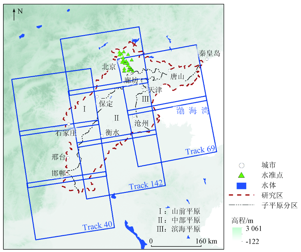
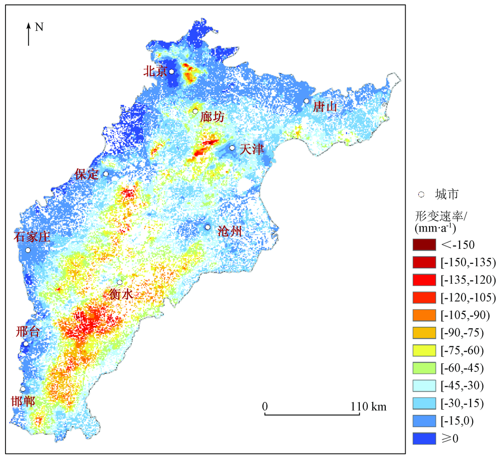
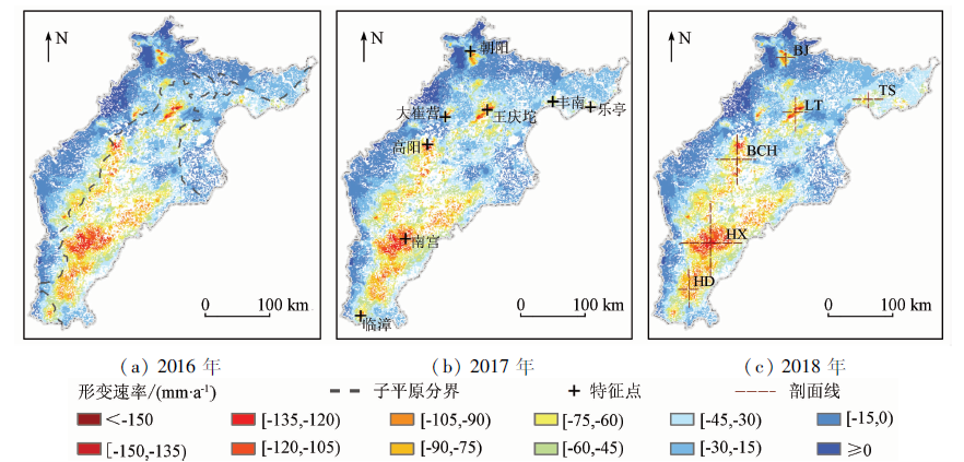
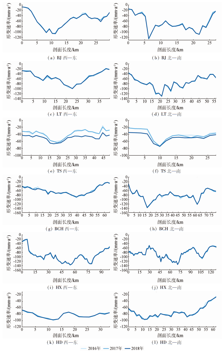
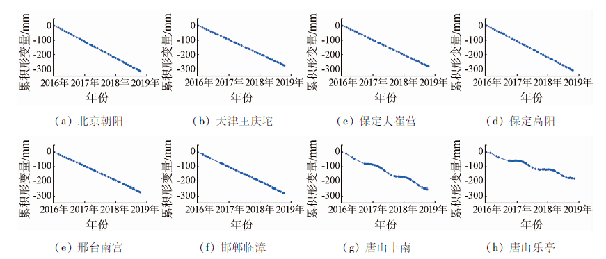
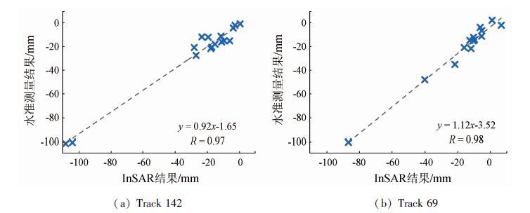
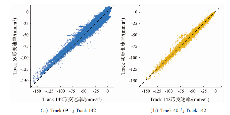
The land subsidence in the Beijing-Tianjin-Hebei (BTH) region has developed the most rapidly and affects the largest area in China and it has become an unnegligible geological problem in the coordinated development of the BTH region. In this study, the multi-track Sentinel-1A data from January 2016 to October 2018 that cover the whole BTH plain was processed using the multi-temporal InSAR (MT-InSAR) technique. After the verification using leveling data and the cross-validation using the data from adjacent tracks, the land subsidence in the BTH region during 2016—2018 were obtained by integrating multi-track SAR data results. The InSAR monitoring results show that the maximum subsidence rate in the BTH region reached 164 mm/a and the land subsidence was widely and unevenly distributed in space in the study area during the monitoring period. According to the analysis of the spatial-temporal change characteristics of the land subsidence in the BTH region, the land subsidence showed an increasing trend in the Tangshan-Qinhuangdao area but stably developed in the remaining areas in the BTH region during 2016—2018. This paper demonstrates that the reliability of the InSAR technique in the monitoring of land subsidence in large regions. The results of this study will provide an important basis for the prevention and mitigation of regional subsidence and will provide a scientific guarantee for the construction of the BTH urban agglomeration.
史珉, 宫辉力, 陈蓓蓓, 高明亮, 张舜康. Sentinel-1A京津冀平原区2016—2018年地面沉降InSAR监测[J]. 自然资源遥感, 2021, 33(4): 55-63.
SHI Min, GONG Huili, CHEN Beibei, GAO Mingliang, ZHANG Shunkang. Monitoring of land subsidence in Beijing-Tianjin-Hebei plain during 2016—2018 based on InSAR and Sentinel-1A data. Remote Sensing for Natural Resources, 2021, 33(4): 55-63.
Guo H P, Bai J B, Zhang Y Q, et al. The evolution characteristics and mechanism of the land subsidence in typical areas of the North China Plain[J]. Geology in China, 2017,44(6):1115-1127.
Lyu X W, Song L, Shao X, et al. The suggestion and application of land subsidence monitoring in Tianjin[J]. Shanghai Land and Resources, 2017,38(2):26-30.
Li H J, Zhang Y W, Meng J, et al. Characteristics on land subsidence in North China Plain within effect of neotectonic movement[J]. China Energy and Environmental Protection, 2017,39(6):57-62.
[4]
杨艳. 京津冀区域地面沉降灾害防治思考[J]. 城市地质, 2015(1):1-7.
Yang Y. Land subsidence disaster prevention and cure in Beijing-Tianjin-Hebei area,China[J]. Urban Geology, 2015(1):1-7.
Zhu J J, Li Z W, Hu J. Research progress and methods of InSAR for deformation monitoring[J]. Acta Geodaetica et Cartographica Sinica, 2017,46(10):1717-1733.
Lin H, Ma P F, Wang W X. Urban infrastructure health monitoring with spaceborne multi-temporal synthetic aperture Radar interferometry[J]. Acta Geodaetica et Cartographica Sinica, 2017,46(10):1421-1433.
[7]
Hu B, Wang H S, Sun Y L, et al. Long-term land subsidence monitoring of Beijing (China) using the small baseline subset (SBAS) technique[J]. Remote Sensing, 2014,6(5):3648-3661.
doi: 10.3390/rs6053648
[8]
Du Z Y, Ge L L, Ng A, et al. Mapping land subsidence over the eastern Beijing City using satellite Radar interferometry[J]. International Journal of Digital Earth, 2018,11(5):504-519.
doi: 10.1080/17538947.2017.1336651
[9]
Gao M L, Gong H L, Chen B B, et al. Regional land subsidence analysis in eastern Beijing Plain by InSAR time series and wavelet transforms[J]. Remote Sensing, 2018,10(3):365.
doi: 10.3390/rs10030365
[10]
Hu L Y, Dai K R, Xing C Q, et al. Land subsidence in Beijing and its relationship with geological faults revealed by Sentinel-1 InSAR observations[J]. International Journal of Applied Earth Observation and Geoinformation, 2019,82:101886.
doi: 10.1016/j.jag.2019.05.019
[11]
Lyu M Y, Ke Y H, Guo L, et al. Change in regional land subsidence in Beijing after south-to-north water diversion project observed using satellite Radar interferometry[J]. GIScience Remote Sensing, 2019,57:140-156.
doi: 10.1080/15481603.2019.1676973
Lei K C, Chen B B, Gong H L, et al. Detection of land subsidence in Tianjin based on PS-InSAR technology[J]. Hydrogeology and Engineering Geology, 2013,40(6):106-111.
[13]
Luo Q L, Perissin D, Zhang Y Z, et al. L-and X-band multi-temporal InSAR analysis of Tianjin subsidence[J]. Remote Sensing, 2014,6(9):7933-7951.
doi: 10.3390/rs6097933
[14]
Liu P, Li Q Q, Li Z H, et al. Anatomy of subsidence in Tianjin from time series InSAR[J]. Remote Sensing, 2016,8(3):266.
doi: 10.3390/rs8030266
[15]
Zhang T X, Shen W B, Wu W H, et al. Recent surface deformation in the Tianjin area revealed by Sentinel-1A Data[J]. Remote Sensing, 2019,11(2):130.
doi: 10.3390/rs11020130
Zhang L, Ge D Q, Guo X F, et al. Land subsidence in Cangzhou over the last decade based on interferometric time series analysis[J]. Shanghai Land and Rescources, 2014,35(4):72-76,80.
[17]
Liu X X, Wang Y J, Yan S Y. Ground deformation associated with exploitation of deep groundwater in Cangzhou City measured by multi-sensor synthetic aperture Radar images[J]. Environmental Earth Sciences, 2017,76(1):6.
doi: 10.1007/s12665-016-6311-0
Zhou H Y, Wang Y J, Yan S Y, et al. Land subsidence monitoring and analyzing of Cangzhou area Sentinel-1A/B based time series InSAR[J]. Bulletin of Surveying and Mapping, 2017(7):89-93.
Zhou X, Xu C J, Wen Y M. Land subsidence monitoring of Beijing and Langfang of Hebei Province by time series InSAR[J]. Science of Surveying and Mapping, 2017,42(7):89-93.
Li H J, Zhang Y W, Yang Y Q, et al. Spatial-temporal distribution characteristics and causation analysis of land subsidence in three northern counties area of Langfang[J]. Science Technology and Engineering, 2018,18(11):23-30.
Guo H P, Li W P, Wang L Y, et al. Present situation and research prospects of the land subsidence driven by groundwater levels in the North China Plain[J]. Hydrogeology and Engineering Geology, 2021,48(3):162-171.
Bai Z C. Subsidence monitoring of Tianjin using PSInSAR technique with Sentinel-1A[J]. Journal of Geomatics Science and Technology, 2017,34(3):283-288.
[24]
Perissin D, Wang Z, Lin H. Shanghai subway tunnels and highways monitoring through Cosmo-SkyMed persistent scatterers[J]. ISPRS Journal of Photogrammetry and Remote Sensing, 2012,73:58-67.
doi: 10.1016/j.isprsjprs.2012.07.002
Guo L Q, Bo W J, Yang G H. Characteristics of current deformation of fault belts in North China[J]. Journal of Geodesy and Geodynamics, 2003,23(2):29-36.
Zhang J C, Chu L F, Xiao Z, et al. Main progress and achievements of land subsidence survey and monitoring in Hebei Plain[J]. Geological Survey of China, 2014,1(2):45-50.
He Q C, Liu W B, Li Z M. Land subsidence survey and monitoring in the North China Plain[J]. Geological Journal of China Universities, 2006,12(2):195-209.
[29]
Ge D, Zhang L, Wang Y, et al. Merging multi-track PSI result for land subsidence mapping over very extended area[C]// 2010 IEEE International Geoscience and Remote Sensing Symposium,IEEE, 2010.
Xiong S T, Zeng Q M, Jiao J, et al. Research on connecting PS-InSAR from adjacent tracks for land subsidence monitoring[J]. Journal of Geo-Information Science, 2014(5):797-805.
Zhang Y H, Wu H A, Kang Y H. Ground subsidence over Beijing-Tianjin-Hebei region during three periods of 1992 to 2014 monitored by interferometric SAR[J]. Acta Geodaetica et Cartographica Sinica, 2016,45(9):1050-1058.
Zhang X D, Ge D Q, Xiao B, et al. Study on multi-track integration PS-InSAR monitoring the land:Taking Jinghu highway (Beijing-Hebei) as an example[J]. Bulletin of Surveying and Mapping, 2014(10):67-69.
 2021, Vol. 33
  ), 宫辉力1,2,3,4, 陈蓓蓓1,2,3,4, 高明亮1,2,3,4, 张舜康1,2,3,4