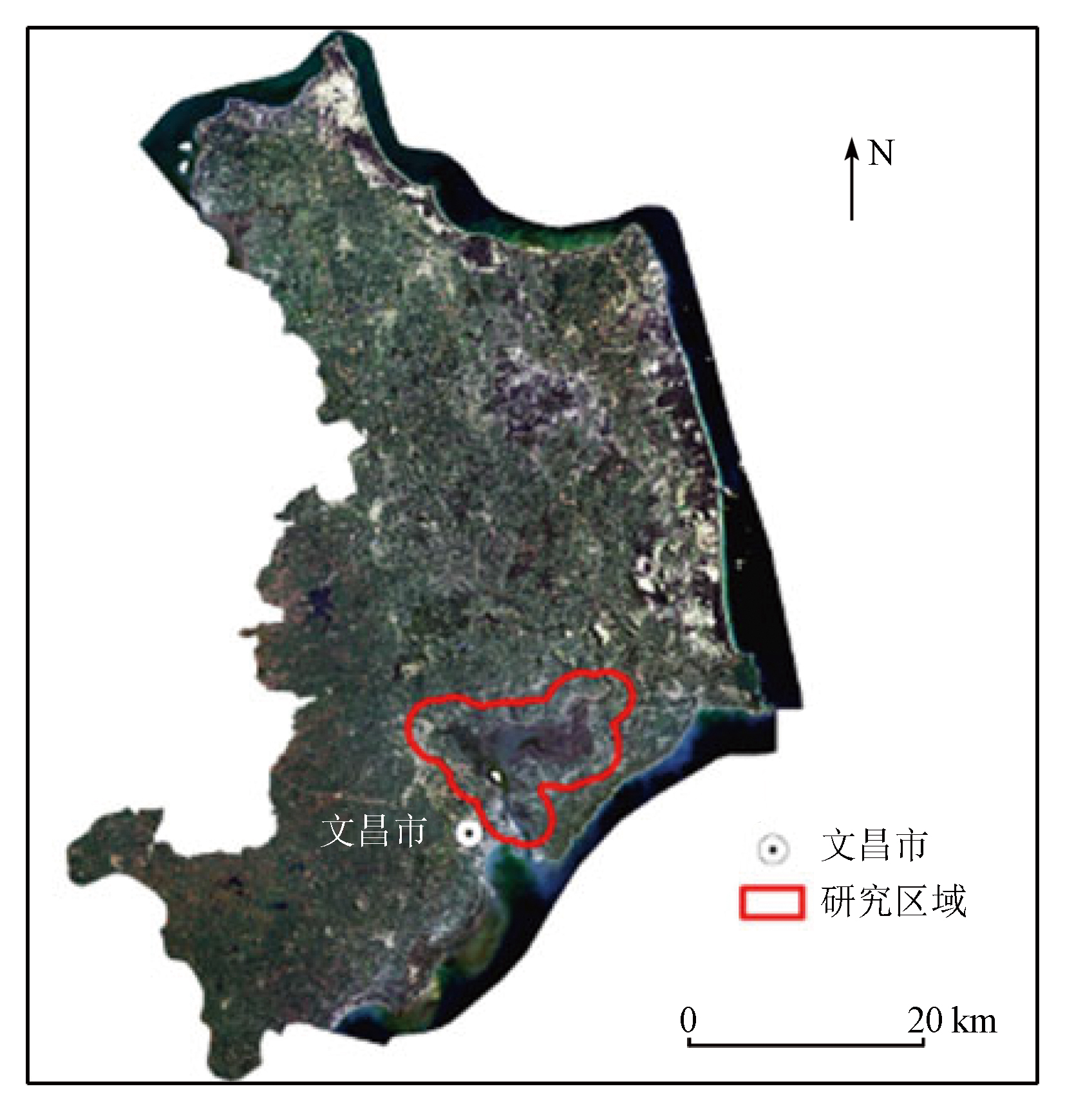
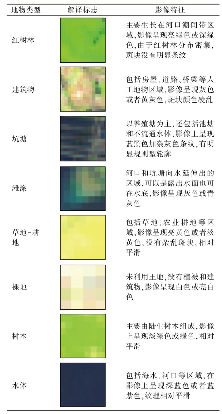
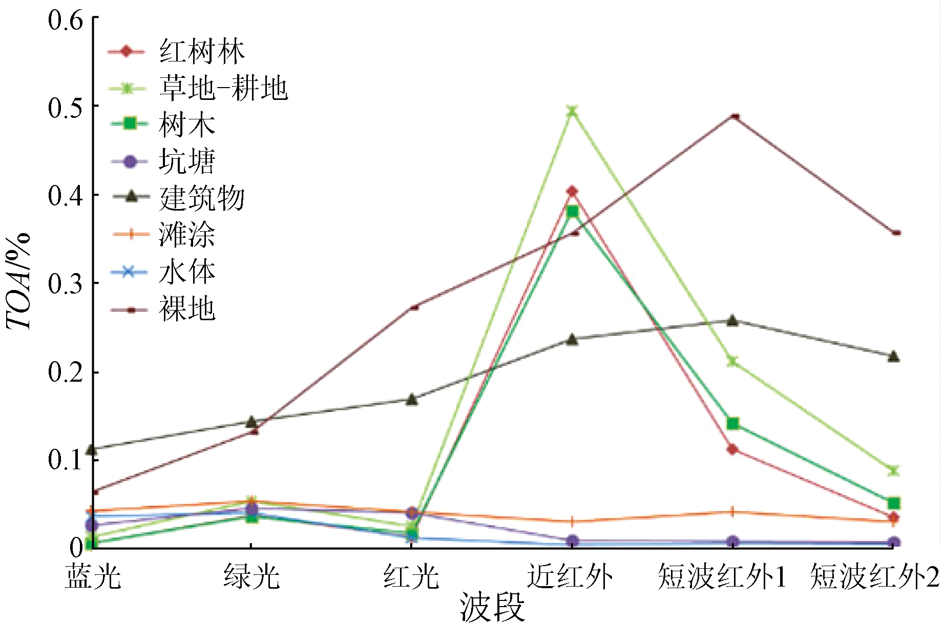
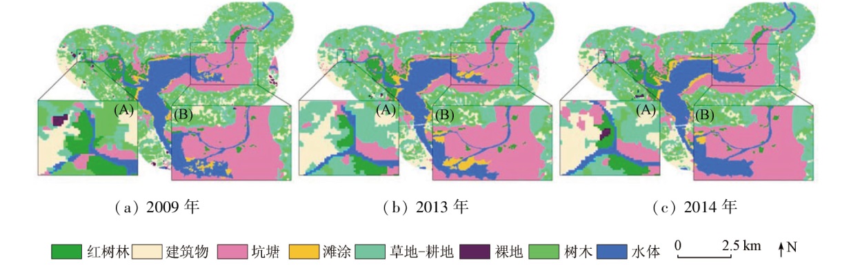
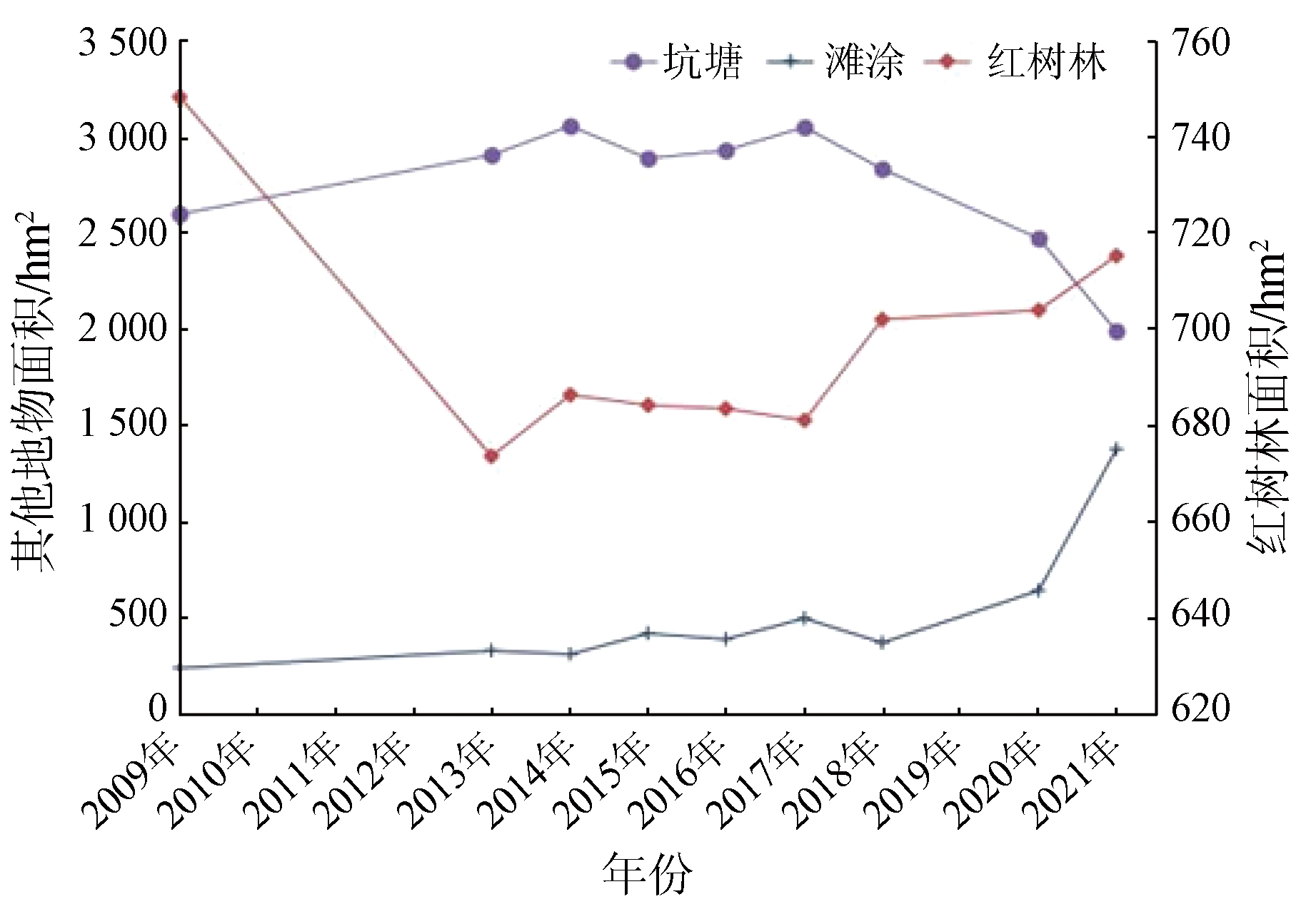
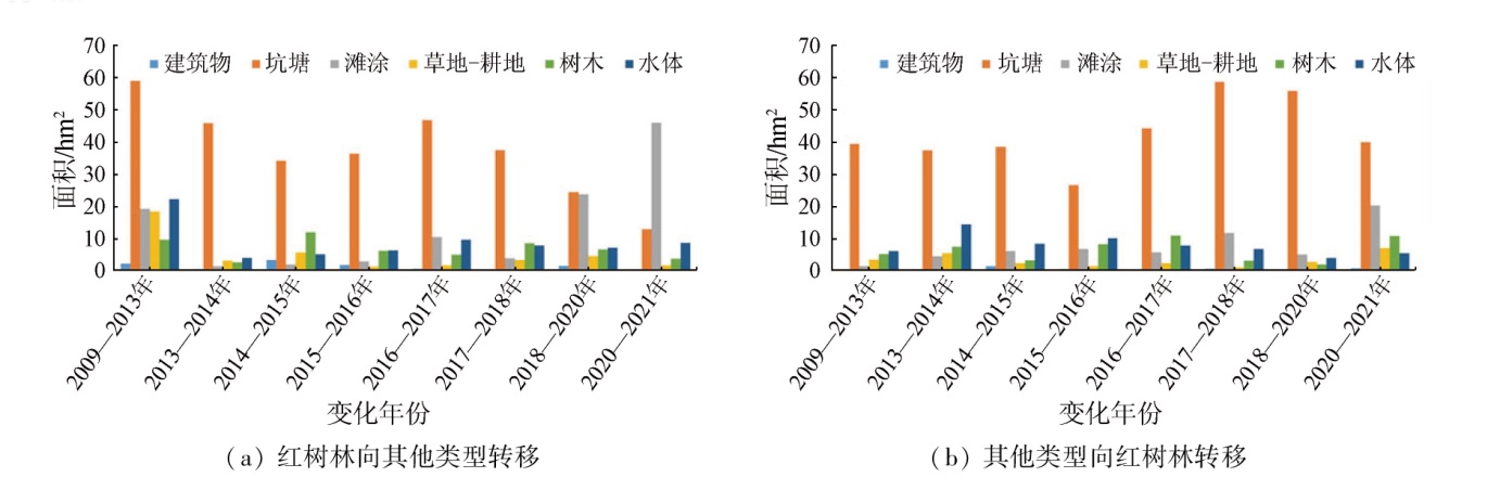
Based on the Google Earth Engine (GEE) cloud platform and Landsat series data, this study classified the surface features of the Bamen Bay area using the support vector machine (SVM) classification method. Furthermore, the classification results were employed to monitor the inter-annual variations of mangrove forests in the area. The analysis reveals that mangrove forests and terrestrial trees exhibit extraordinarily similar reflectance spectral curves except for infrared bands. Hence, they were effectively distinguished using the infrared band feature index and topographic data, achieving an overall classification accuracy of 91%. The classification results show that mangrove forests in the study area manifested a trend of decrease followed by increase. Specifically, they decreased from 2009 to 2013, remained almost unchanged from 2014 to 2016, and increased slowly from 2017 to 2021. The increase in mangrove forests and the decrease in pits and ponds occurred following the wetland restoration policy that requires planting mangrove forests in South China and tamarix chinensis in North China, suggesting remarkable effects of the policy for returning ponds to forests. The transfer matrix analysis reveals a mutual transfer between mangrove forests and pits, ponds, suggesting that deforesting for ponds and returning ponds to forests constitute the primary factors influencing the variations in mangrove forests. The inter-annual variation monitoring results of mangrove forests enable detailed analysis of the evolutionary process of mangrove forests and accurate quantification of the transformation between mangrove forests and other land types. Therefore, the factors influencing mangrove forest evolution can be analyzed from the perspective of economy and policy for more effective preservation of mangrove forests.
薛志泳, 田震, 朱建华, 赵阳. 基于Google Earth Engine的八门湾红树林年际变化监测[J]. 自然资源遥感, 2024, 36(2): 279-286.
XUE Zhiyong, TIAN Zhen, ZHU Jianhua, ZHAO Yang. Monitoring of inter-annual variations in mangrove forests in the Bamen Bay area based on Google Earth Engine. Remote Sensing for Natural Resources, 2024, 36(2): 279-286.
Huang X L, Zhang T, Tan R G. The studies on current status and pre-warning mechanism of mangroves in Hainan[J]. Journal of Jiangxi Normal University(Natural Science), 2018, 42(3):236-241.
Li C. Discussion on the existing problems and development countermeasures of mangroves wetland ecosystem in Qinglangang,Wenchang[J]. Tropical Forestry, 2010, 38(4):4-6.
LI R, Zhu B Q, Tong X W, et al. Change analysis in Hainan Dongzhai Wetland Reserve based on remote sensing data obtained during 2002—2013[J]. Remote Sensing for Land and Resources, 2017, 29(3):149-155.doi:10.6046/gtzyyg.2017.03.22.
[9]
Mohd R S, Radzi M A, Marin A, et al. A bibliometric analysis of tropical mangrove forest land use change from 2010 to 2020[J]. Environment,Development and Sustainability, 2022, 24:11530-11547.
[10]
Maurya K, Mahajan S, Chaube N. Remote sensing techniques:Mapping and monitoring of mangrove ecosystem:A review[J]. Complex & Intelligent Systems, 2021, 7(6):2797-2818.
[11]
Gopalakrishnan L, Satyanarayana B, Chen D, et al. Using Historical archives and Landsat imagery to explore changes in the mangrove cover of Peninsular Malaysia between 1853 and 2018[J]. Remote Sensing, 2021, 13(17):3403-3403.
[12]
Rahman M S, Ibrahim M, Hasan M, et al. Spatio-temporal analysis of land use and land cover changes in Barguna District of Bangladesh using remote sensing techniques:Focusing on mangrove vegetation[J]. Journal of Global Ecology and Environment, 2021, 11(4):43-54.
Ma Y M, Wu P Q, Ren G B. Fine classification and mapping of mangroves in Guangxi coastal zone based on spectral characteristics of GF images[J]. Journal of Geo-Information Science, 2021, 23(12):2292-2304.
Xu X R, Xie G Z, Qiu P H. Dynamic analysis of landscape changes in Bamen port and the surrounding lands of Hainan Province from 1964 to 2015[J]. Acta Ecologica Sinica, 2018, 38(20):7458-7468.
[15]
Moore R T, Hansen M C. Google Earth Engine:A new cloud-computing platform for global-scale earth observation data and analysis[C]// AGU Fall Meeting Abstracts, 2011:IN43C-02.
[16]
Hansen M C, Potapov P V, Moore R T, et al. High-resolution global maps of 21st-century forest cover change[J]. Science, 2013, 342(6160):850-853.
doi: 10.1126/science.1244693
pmid: 24233722
[17]
Chen B, Xiao X, Li X, et al. A mangrove forest map of China in 2015:Analysis of time series Landsat7/8 and Sentinel-1A imagery in Google Earth Engine cloud computing platform[J]. ISPRS Journal of Photogrammetry Remote Sensing, 2017, 131:104-120.
Xue Z H, Qian S Y. Fusion of Landsat8 and Sentinel-2 data for mangrove phenology information extraction and classification[J]. National Remote Sensing Bulletin, 2022, 26(6):1121-1142.
Peng L H, Li X, et al. Monitoring the inter-annual change of mangrove based on the Google Earth Engine[J]. Journal of Geo-Information Science, 2019, 21(5):731-739.
Zhang X H, Tian Q J. Application of the temperature-moisture index to the improvement of remote sensing identification accuracy of mangrove[J]. Remote Sensing for Land and Resources, 2012, 24(3):65-70.doi:10.6046/gtzyyg.2012.03.13.
Zhang X. Decision tree algorithm of automatically extracting mangrove forests information from Landsat8 OLI imagery[J]. Remote Sensing for Land and Resources, 2016, 28(2):182-187.doi:10.6046/gtzyyg.2016.02.28.
[22]
Jensen J R, Lin H, Yang X, et al. The measurement of mangrove characteristics in southwest Florida using SPOT multispectral data[J]. Geocarto International, 1991, 6(2):13-21.
[23]
Cristianini N, Shawe-Taylor J. An introduction to support vector machines and other kernel-based learning methods[M]. Cambridge: Cambridge University Press, 2000.
 2024, Vol. 36
  ), 田震, 朱建华, 赵阳