|
|
|
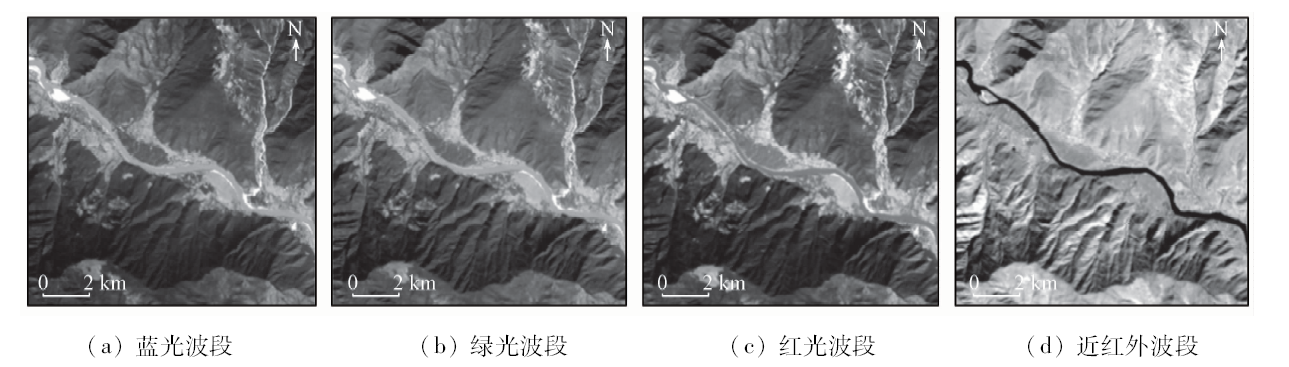
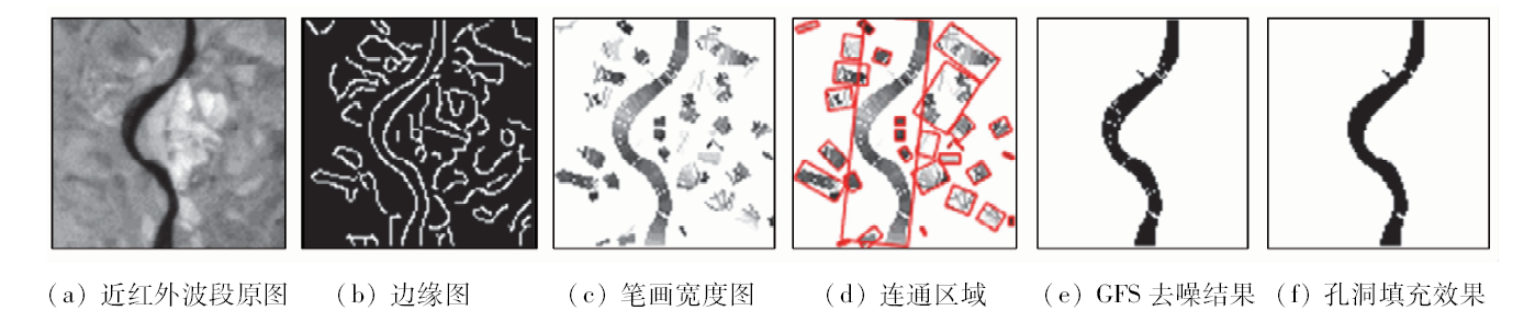
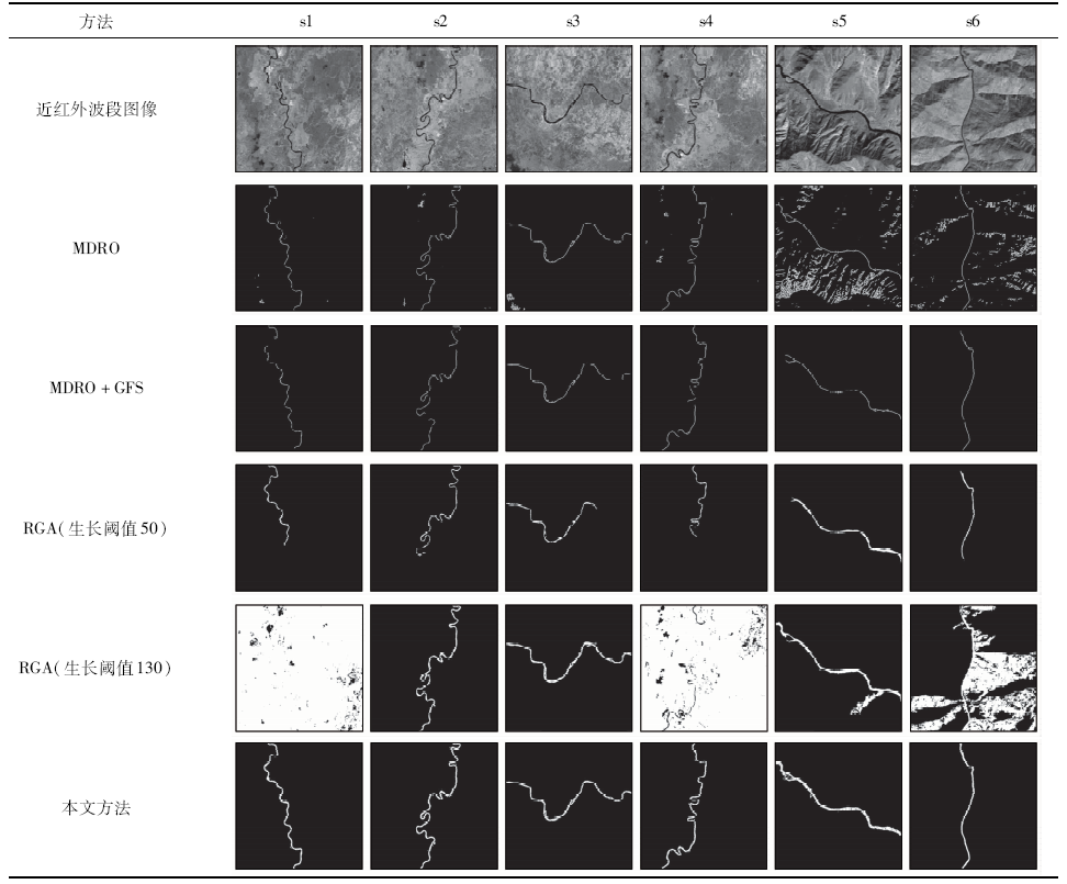
Abstract Extracting rivers from high-resolution satellite images has many important implications. At present, most methods are devoted to extracting rivers from the spectral characteristics or texture analysis of rivers. But for the image which is with the phenomenon of the same object with different spectra or different objects with the same spectra, or has serious noise, or is hard to determine the scale of texture analysis, the method based on water spectrum analysis or texture analysis is not very suitable. The rivers in high-resolution satellite images are generally irregular in structure, and it is more likely that the rivers have different spectral features and texture features due to various reasons. However, in some satellite images, rivers may have approximately uniform width over a wide range. In view of such a situation, a river extraction method combining stroke width transform and geometric feature set is proposed innovatively. Firstly, the Canny edge detector is used to extract the edge of the image, and the edge map is used as the input of the stroke width transform algorithm to obtain the stroke width map. Then, the connected pixels are grouped by using the connected component algorithm, and next, the connected components obtained after the grouping are filtered according to the geometric feature set, and finally the remaining connected components experience the process for filling holes. Experiments using the GF-1 satellite images show that the method can suppress the noise well while extracting the target river. At the same time, compared with the Multiplicative Duda operator and the region growing algorithm, the proposed method has obvious advantages in the aspects of extraction effect and algorithm stability.
|
| Keywords
GF-1
river extraction
stroke width transform
geometric feature set
|
|
|
|
Corresponding Authors:
Baoyun WANG
E-mail: wspbmly@163.com
|
|
Issue Date: 18 June 2020
|
|
|
| [1] |
冷凯群. 基于PLFT及图像融合的卫星河流识别[J]. 计算机工程与设计, 2018,39(12):170-174.
|
| [1] |
Leng K Q. PLFT and images fusion-based satellite rivers detection[J]. Computer Engineering and Design, 2018,39(12):170-174.
|
| [2] |
Zhang Y. A method for continuous extraction of multispectrally classified urban rivers[J]. Photogrammetric Engineering and Remote Sensing, 2000,66:991-999.
|
| [3] |
Rani G M D, Viswanath K. Extraction of river from satellite images [C]// 2nd International Conference on Recent Trends in Electronics,Information & Communication Technology(RTEICT 2017).IEEE, 2017: 226-230.
|
| [4] |
Matgen P, Hostache R, Schumann G, et al. Towards an automated SAR-based flood monitoring system:Lessons learned from two case studies[J]. Physics & Chemistry of the Earth, 2011,36(7):241-252.
|
| [5] |
姜浩, 冯敏, 肖桐, 等. 基于线状特征增强的TM遥感影像细小河流提取方法[J].测绘学报, 2014(7):705-710.
url: http://xb.sinomaps.com:8081/Jwk_chxb/CN/abstract/abstract6354.shtml
|
| [5] |
Jiang H, Feng M, Xiao T, et al. A narrow river extraction method based on linear feature enhancement in TM image[J].Acta Geodaetica et Cartographica Sinica, 2014(7):705-710.
|
| [6] |
Dillabaugh C R, Niemann K O, Richardson D E. Semi-Automated extraction of rivers from digital imagery[J]. GeoInformatica, 2002,6(3):263-284.
doi: 10.1023/A:1019718019825
url: http://www.springerlink.com/content/jg6jju064r7l9306/
|
| [7] |
王民, 卞琼, 高路. 高分辨率遥感卫星影像的河流提取方法研究[J]. 计算机工程与应用, 2014,50(18):193-196.
url: http://cea.ceaj.org/CN/abstract/abstract32367.shtml
|
| [7] |
Wang M, Bian Q, Gao L. High resolution satellite remote sensing images’ rivers extraction method[J]. Computer Engineering and Application, 2014,50(18):193-196.
|
| [8] |
Molina R E. River extraction from high resolution satellite images [C]// International Congress on Image & Signal Processing.IEEE, 2012: 697-700.
|
| [9] |
Sghaier M O, Foucher S, Lepage R. River extraction from high-resolution SAR images combining a structural feature set and mathematical morphology[J]. IEEE Journal of Selected Topics in Applied Earth Observations and Remote Sensing, 2017,10(3):1025-1038.
|
| [10] |
Huang X, Zhang L, Li P. Classification and extraction of spatial features in urban areas using high-resolution multispectral imagery[J]. IEEE Geoscience & Remote Sensing Letters, 2007,4(2):260-264.
|
| [11] |
He X, Wu Y. Texture feature extraction method combining nonsubsampled contour transformation with gray level co-occurrence matrix[J]. Journal of Multimedia, 2013,8(6):675-684.
|
| [12] |
Sghaier M O, Foucher S, Lepage R, et al. A multiscale based approach for river extraction from SAR images using attribute filters [C]// International Geoscience and Remote Sensing Symposium(IGARSS 2018).IEEE, 2018: 9245-9248.
|
| [13] |
Jameson J. Extraction of arbitrary text in natural scene image based on stroke width transform [C]// 14th International Conference on Intelligent Systems Design and Applications(ISDA 2014).IEEE, 2014: 124-128.
|
| [14] |
张国和, 黄凯, 张斌, 等. 最大稳定极值区域与笔画宽度变换的自然场景文本提取方法[J]. 西安交通大学学报, 2017,51(1):135-140.
|
| [14] |
Zhang G H, Huang K, Zhang B, et al. A natural scene text extration method based on the maximum stable extremal region and stroke width transform[J]. Journal of Xi’an Jiaotong University, 2017,51(1):135-140.
|
| [15] |
Epshtein B, Ofek E, Wexler Y. Detecting text in natural scenes with stroke width transform [C]// Computer Society Conference on Computer Vision and Pattern Recognition(CVPR 2010).IEEE, 2010: 2963-2970.
|
| [16] |
童庆禧, 张兵, 郑兰芬. 高光谱遥感:原理、技术与应用[M]. 北京: 高等教育出版社, 2006: 26.
|
| [16] |
Tong Q X, Zhang B, Zhang L F. Hyperspectral remote sensing:Theory,technology and applications[M]. Beijing: Higher Education Press, 2006: 26.
|
| [17] |
张仁华. 定量热红外遥感模型及地面实验基础[M]. 北京: 科学出版社, 2009: 74-76.
|
| [17] |
Zhang R H. Quantitative thermal infrared remote sensing model and ground experimental basis[M]. Beijing: Science Press, 2009: 74-76.
|
| [18] |
Sghaier M O, Hammami I, Foucher S, et al. Stroke width transform for linear structure detection:Application to river and road extraction from high-resolution satellite images [C]// International Conference Image Analysis and Recognition(ICIAR 2017), 2017: 605-613.
|
| [19] |
Canny J. A computational approach to edge detection[M]. IEEE Transactions on Pattern Analysis and Machine Intelligence, 1986,8(6):679-698.
|
| [20] |
Dillencourt M B, Samet H, Tamminen M. A general approach to connected-component labeling for arbitrary image representations[J]. Journal of the ACM, 1992,39(2):253-280.
|
| [21] |
Geling G, Ionescu D. An edge detection operator for SAR images [C]// Conference on Electrical & Computer Engineering.IEEE, 1993: 707-709.
|
| [22] |
张蕾.红外图像中铁轨识别技术的研究[D].成都:电子科技大学, 2012.
|
| [22] |
Zhang L. The research on identification of rail from infrared image[D]. Chengdu:University of Electronic Science and Technology of China, 2012.
|
| [23] |
Hu J, Razdan A, Femiani J C, et al. Road Network Extraction and Intersection Detection From Aerial Images by Tracking Road Footprints[J]. IEEE Transactions on Geoscience and Remote Sensing, 2007,45(12):4144-4157.
doi: 10.1109/TGRS.2007.906107
url: http://ieeexplore.ieee.org/document/4378557/
|
|
Viewed |
|
|
|
Full text
|
|
|
|
|
Abstract
|
|
|
|
|
Cited |
|
|
|
|
| |
Shared |
|
|
|
|
| |
Discussed |
|
|
|
|
 2020,
Vol. 32
2020,
Vol. 32
 ), Yumei SUN, Caidong LI, Xianchen SUN, Lingli ZHANG