|
|
 |
|

|
|
|
Geo-detector based spatio-temporal variation characteristics and driving factors analysis of NDVI in Central Asia |
Wei WANG1,2,3, Samat Alim1,3, Abuduwaili Jilili1,2,3( ) ) |
1. State Key Laboratory of Desert and Oasis Ecology, Xinjiang Institute of Ecology and Geography, Chinese Academy of Sciences,Urumqi 830011, China
2. University of Chinese Academy of Sciences, Beijing 100049, China
3. Research Center for Ecology and Environment of Central Asia, Chinese Academy of Science, Urumqi 830011, China |
|
|
|
|
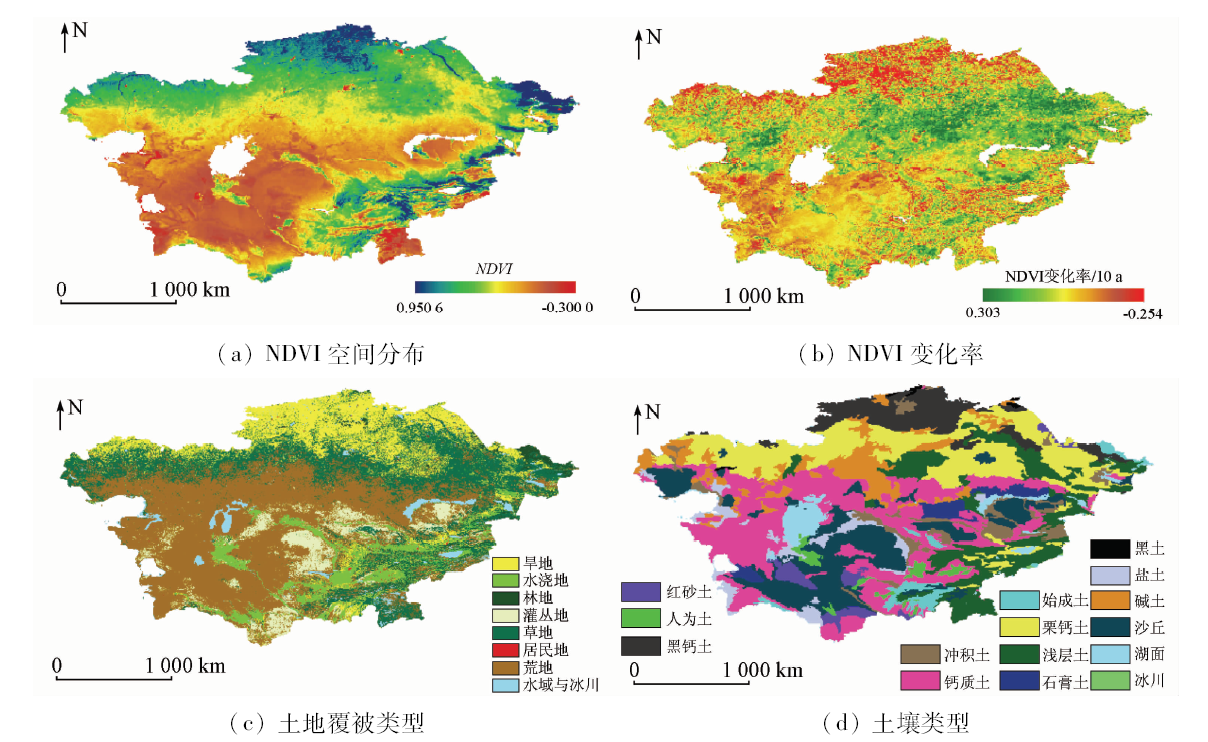
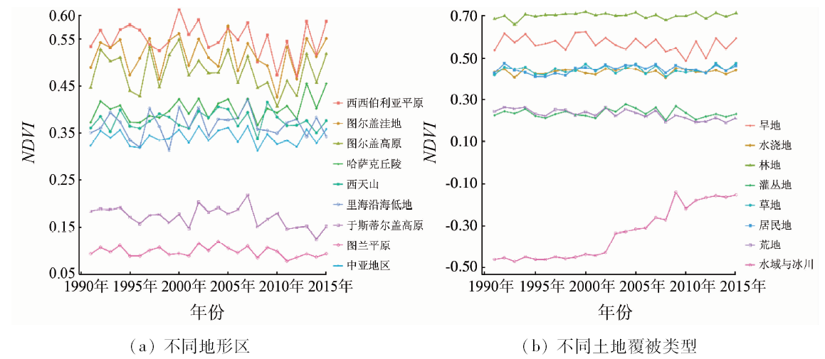
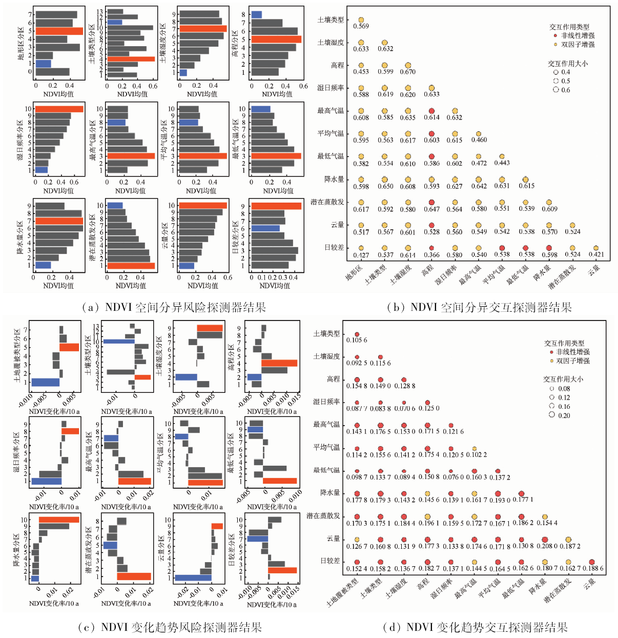
Abstract Vegetation is an important nexus connecting atmosphere, pedosphere, hydrosphere and biosphere. Therefore, the relationship between the temporal and spatial variation characteristics of vegetation and its driving factors is of great significance in the study of regional ecological environment changes. Based on multiple data sets such as GIMMS NDVI and CRU, the authors analyzed the temporal and spatial variation characteristics of NDVI in Central Asia from 1991 to 2015, using trend analysis and geo-detector model that included factor detection, risk detection and interaction analysis. The results show that the vegetation activities in Central Asia have remained stable and volatile on the whole in the past 25 years. In detail, NDVI in the middle and low altitude areas of the Kazakh hills has increased significantly, while the NDVI in the southwestern part of Aral Sea has been significantly reduced because of the close diffusion of salt dust in the Aral Sea basin. In addition, because of the contradiction between water resources development and utilization among Central Asian countries, the trend of NDVI in the midstream of the Syr Darya and the downstream has been reversed. The non-irrigated farmland in northern Kazakhstan has a large decline in NDVI, and the results are not significant (P≥0.1) due to the phenomenon of re-cultivation. According to the results of geo-detector model, the water factor dominates the vegetation growth pattern in Central Asia, and the temperature is negatively correlated with the NDVI change. The difference in spatial and temporal variation of NDVI between different terrains, elevations, soil types and land use types is also significant. In terms of the interaction factor, the bi-factor interaction has enhanced the interpretation of spatial distribution and temporal and spatial variation of NDVI. The synergistic effect of potential evapotranspiration and elevation on the spatial distribution of NDVI is over 64%.
|
| Keywords
NDVI
Central Asia
geographical detector
trend analysis
temporal and spatial variation
|
|
|
|
Corresponding Authors:
Abuduwaili Jilili
E-mail: jilil@ms.xjb.ac.cn
|
|
Issue Date: 03 December 2019
|
|
|
| [1] |
Chen F H, Wang J S, Jin L Y , et al. Rapid warming in mid-latitude Central Asia for the past 100 years[J]. Frontiers of Earth Science in China, 2009,3(1):42-50.
|
| [2] |
秦大河 . 气候变化科学概论[M]. 北京: 科学出版社, 2018: 35-38.
|
| [2] |
Qin D H. Introduction to Climate Change Science[M]. Beijing: Science Press, 2018: 35-38.
|
| [3] |
Klein I, Gessner U, Kuenzer C . Regional land cover mapping and change detection in Central Asia using MODIS time-series[J]. Applied Geography, 2012,35(1-2):219-234.
|
| [4] |
Micklin P .The future Aral Sea:Hope and despair[J].Environmental Earth Sciences, 2016, 75(9): 844, 1-15.
|
| [5] |
Bezborodov G A, Shadmanov D K, Mirhashimov R T , et al. Mulching and water quality effects on soil salinity and sodicity dynamics and cotton productivity in Central Asia[J]. Agriculture Ecosystems and Environment, 2010,138(1):95-102.
|
| [6] |
程彦培, 张发旺, 董华 , 等. 基于MODIS卫星数据的中亚地区水体动态监测研究[J]. 水文地质工程地质, 2010,37(5):33-37.
doi: 10.3969/j.issn.1000-3665.2010.05.006
url: http://d.wanfangdata.com.cn/Periodical/swdzgcdz201005006
|
| [6] |
Cheng Y P, Zhang F W, Dong H , et al. Wetland dynamic monitoring in Central Asia based on MODIS image[J]. Hydrogeology and Engineering Geology, 2010,37(5):33-37.
|
| [7] |
成晨, 傅文学, 胡召玲 , 等. 基于遥感技术的近30年中亚地区主要湖泊变化[J]. 国土资源遥感, 2015,27(1):146-152.doi: 10.6046/gtzyyg.2015.01.23.
doi: 10.6046/gtzyyg.2015.01.23
|
| [7] |
Cheng C, Fu W X, Hu Z L , et al. Changes of major lakes in Central Asia over the past 30 years revealed by remote sensing technology[J]. Remote Sensing for Land and Resources, 2015,27(1):146-152.doi: 10.6046/gtzyyg.2015.01.23.
|
| [8] |
Schwartz M D . Green-wave phenology[J]. Nature, 1998,394(6696):839-840.
|
| [9] |
殷刚, 孟现勇, 王浩 , 等. 1982—2012年中亚地区植被时空变化特征及其与气候变化的相关分析[J]. 生态学报, 2017,37(9):3149-3163.
doi: 10.5846/stxb201601240164
|
| [9] |
Yin G, Meng X Y, Wang H , et al. Spatial-temporal variation of vegetation and its correlation with climate change in Central Asia during the period of 1982—2012[J]. Acta Ecologica Sinica, 2017,37(9):3149-3163.
|
| [10] |
邓兴耀, 姚俊强, 刘志辉 . 基于GIMMS NDVI的中亚干旱区植被覆盖时空变化[J]. 干旱区研究, 2017,34(1):10-19.
|
| [10] |
Deng X Y, Yao J Q, Liu Z H . Spatiotemporal dynamic change of vegetation coverage in arid regions in Central Asia based on GIMMS NDVI[J]. Arid Zone Research, 2017,34(1):10-19.
|
| [11] |
索玉霞, 王正兴, 刘闯 , 等. 中亚地区1982年至2002年植被指数与气温和降水的相关性分析[J]. 资源科学, 2009,31(8):1422-1429.
url: http://d.wanfangdata.com.cn/Periodical/zykx200908023
|
| [11] |
Suo Y X, Wang Z X, Liu C , et al. Relationship between NDVI and precipitation and temperature in Middle Asia during 1982—2002[J]. Resources Science, 2009,31(8):1422-1429.
|
| [12] |
张琪, 袁秀亮, 陈曦 , 等. 1982—2012年中亚植被变化及其对气候变化的响应[J]. 植物生态学报, 2016,40(1):13-23.
doi: 10.17521/cjpe.2015.0236
|
| [12] |
Zhang Q, Yuan X L, Chen X , et al. Vegetation change and its response to climate change in Central Asia from 1982 to 2012[J]. Chinese Journal of Plant Ecology, 2016,40(1):13-23.
|
| [13] |
索玉霞 . 中亚五国植被覆盖变化与气候因子相关性分析[D]. 北京:中国科学院研究生院, 2009.
|
| [13] |
Suo Y X . Correlation of Vegetation Dynamics and Climate Variability in the Middle Asia[D]. Beijing:Graduate School of Chinese Academy of Science, 2009.
|
| [14] |
Shigaeva J, Kollmair M, Niederer P , et al. Livelihoods in transition:Changing land use strategies and ecological implications in a post-Soviet setting (Kyrgyzstan)[J]. Central Asian Survey, 2007,26(3):389-406.
|
| [15] |
王劲峰, 徐成东 . 地理探测器:原理与展望[J]. 地理学报, 2017,72(1):116-134.
doi: 10.11821/dlxb201701010
|
| [15] |
Wang J F, Xu C D . Geodetector:Principle and prospective[J]. Acta Geographica Sinica, 2017,72(1):116-134.
|
| [16] |
胡汝骥, 姜逢清, 王亚俊, 等 .中亚(五国) 干旱生态地理环境特征[J]. 干旱区研究, 2014,31(1):1-12.
|
| [16] |
Hu R J, Jiang F Q, Wang Y J , et al. Arid ecological and geographical conditions in five countries of Central Asia[J]. Arid Zone Research, 2014,31(1):1-12.
|
| [17] |
吉力力·阿不都外力, 马龙 . 中亚环境概论[M]. 北京: 气象出版社, 2015: 275-293.
|
| [17] |
Abuduwaili J, Ma L. Overview of Central Asian Environments[M]. Beijing: China Meteorological Press, 2015: 275-293.
|
| [18] |
刘宪锋, 朱秀芳, 潘耀忠 , 等. 1982—2012年中国植被覆盖时空变化特征[J]. 生态学报, 2015,35(16):5331-5342.
doi: 10.5846/stxb201404150731
|
| [18] |
Liu X F, Zhu X F, Pan Y Z , et al. Spatiotemporal changes in vegetation coverage in China during 1982—2012[J]. Acta Ecologica Sinica, 2015,35(16):5331-5342.
|
| [19] |
刘家福, 马帅, 李帅 , 等. 1982—2016年东北黑土区植被NDVI动态及其对气候变化的响应[J]. 生态学报, 2018,38(21):7647-7657.
doi: 10.5846/stxb201712112226
|
| [19] |
Liu J F, Ma S, Li S , et al. Changes in vegetation NDVI from 1982 to 2016 and its responses to climate change in the black-soil area of Northeast China[J]. Acta Ecologica Sinica, 2018,38(21):7647-7657.
|
| [20] |
穆少杰, 李建龙, 周伟 , 等. 2001—2010年内蒙古植被净初级生产力的时空格局及其与气候的关系[J]. 生态学报, 2013,33(12):3752-3764.
doi: 10.5846/stxb201205030638
|
| [20] |
Mu S J, Li J L, Zhou W , et al. Spatial-temporal distribution of net primary productivity and its relationship with climate factors in Inner Mongolia from 2001 to 2010[J]. Acta Ecologica Sinica, 2013,33(12):3752-3764.
|
| [21] |
赵宁, 马超, 杨亚莉 . 1973—2013年红碱淖水域水质变化及驱动力分析[J]. 湖泊科学, 2016,28(5):982-993.
|
| [21] |
Zhao N, Ma C, Yang Y L . Water quality variation of Lake Hongjiannao and its driving force analysis from 1973 to 2013[J]. Journal of Lake Sciences, 2016,28(5):982-993.
|
| [22] |
Dara A, Baumann M, Kuemmerle T , et al. Mapping the timing of cropland abandonment and recultivation in northern Kazakhstan using annual Landsat time series[J]. Remote Sensing of Environment, 2018,213:49-60.
|
| [23] |
Shen H, Abuduwaili J, Samat A , et al.A review on the research of modern aeolian dust in Central Asia[J].Arabian Journal of Geosciences, 2016, 9(13): 625, 1-16.
|
| [24] |
Ge Y X, Abuduwaili J, Ma L, et al.Temporal variability and potential diffusion characteristics of dust aerosol originating from the Aral Sea Basin, Central Asia[J].Water Air and Soil Pollution , 2016, 227(2): 63, 1-12.
|
| [25] |
吴淼, 张小云, 罗格平 , 等. 哈萨克斯坦水资源利用[J]. 干旱区地理, 2010,33(2):196-202.
|
| [25] |
Wu M, Zhang X Y, Luo G P , et al. Situation of water resources utilization in Kazakhstan[J]. Arid Land Geography, 2010,33(2):196-202.
|
|
Viewed |
|
|
|
Full text
|
|
|
|
|
Abstract
|
|
|
|
|
Cited |
|
|
|
|
| |
Shared |
|
|
|
|
| |
Discussed |
|
|
|
|
 2019,
Vol. 31
2019,
Vol. 31