|
|
|
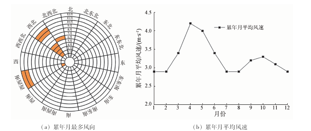
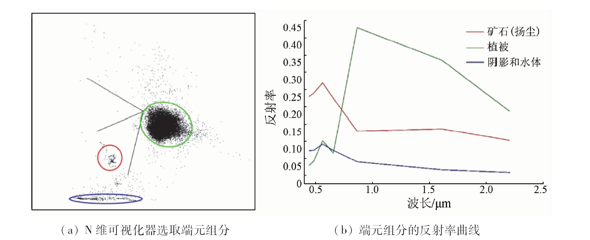
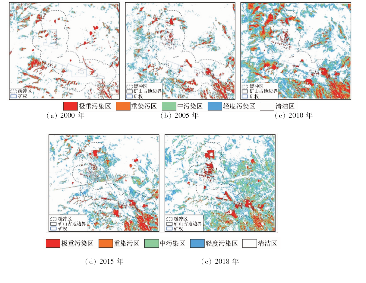
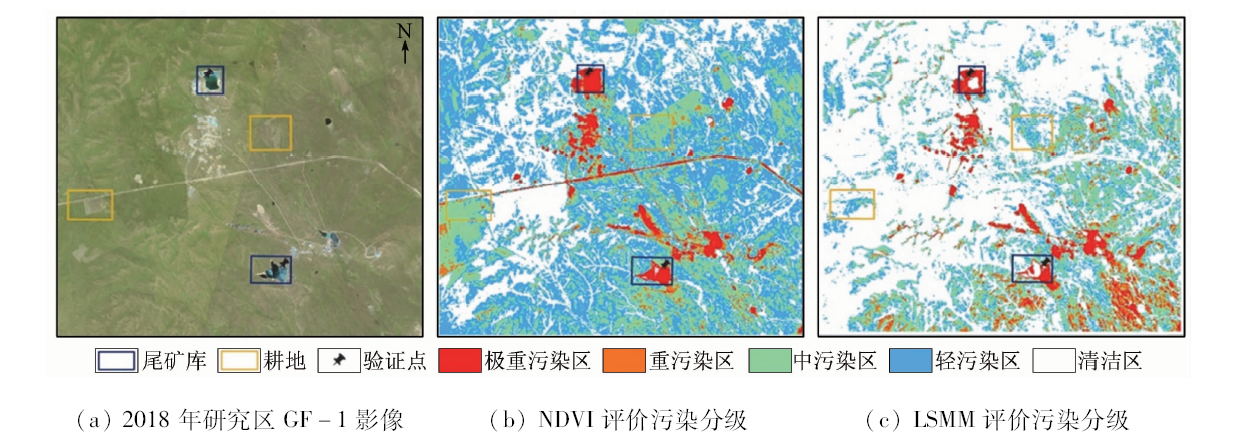
Abstract The Awula-Chagan lead-zinc-silver mine in Xin Barag Right Banner of Inner Mongolia is located in the abdomen of Hulunbuir grassland. Its semi-arid climate makes tailings ponds, solid waste piles and ore piles easily generate dust, polluting surrounding grassland. The traditional chemical sampling and spectral analysis investigate the high precision of the mining area but they are time-consuming and labor-intensive. It is convenient to use the time-series remote sensing method to monitor the dust pollution in the mining area. In this paper, GF-1 satellite data in 2018 were used to extract the information of the mining area in the study area. Based on an analysis of the wind field and the best observation month in the study area, the authors used the five-phase Landsat satellite data to adopt the end-element decomposition model of “dust accumulation-vegetation-water and shadow”, and used the method of semi-automatic elimination of road interference by manual intervention to remove the effects of roads. Compared with NDVI index analysis method, the proposed method considers the vegetation spectral information and takes into account the spectral information of the dust, thus making the monitoring effect more objective. A comparative study of 5 remote sensing image aeolian dust extractions found that, as of 2018, the mining area 1 km buffer aeolian dust contamination area expanded to 190.57 hm2, of which annual average growth area in 2000—2010 and 2010—2018 were 14.72 hm2 and 0.64 hm2, respectively. The monitoring results show that the prevention and control measures adopted in the mining area can significantly improve the pollution of dust and wind accumulations; nevertheless, with the further development of the mining area, ecological restoration and management should also be conducted in time.
|
| Keywords
mining area
dust pollution
Linear Spectral Mixing Model
NDVI
time series monitoring
|
|
|
|
Corresponding Authors:
Zhi ZHANG
E-mail: 171560655@qq.com
|
|
Issue Date: 18 June 2020
|
|
|
| [1] |
孙启忠. 试谈对做好草原大文章的理解[J]. 中国草地学报, 2009,31(1):13-16.
|
| [1] |
Sun Q Z. A Discussion on the understanding of doing a good prairie article[J]. Chinese Journal of Grassland, 2009,31(1):13-16.
|
| [2] |
马超, 张晓克, 郭增长, 等. 半干旱山区采矿扰动植被指数时空变化规律[J]. 环境科学研究, 2013,26(7):750-758.
|
| [2] |
Ma C, Zhang X K, Guo Z Z, et al. Spatiotemporal variation of vegetation disturbance vegetation index in semi-arid mountainous areas[J]. Research of Environmental Sciences, 2013,26(7):750-758.
|
| [3] |
Przezdziecki K, Zawadzki J, Miatkowski Z. Use of the temperature-vegetation dryness index for remote sensing grassland moisture conditions in the vicinity of a lignite open-cast mine[J]. Environmental Earth Sciences, 2018,77(17):1-13.
|
| [4] |
高云峰, 徐友宁, 祝雅轩, 等. 矿山生态环境修复研究热点与前沿分析——基于VOSviewer和CiteSpace的大数据可视化研究[J]. 地质通报, 2018,37(12):2144-2153.
|
| [4] |
Gao Y F, Xu Y N, Zhu Y X, et al. Study on hotspots and frontier analysis of mine ecological environment restoration:Research on big data visualization based on VOSviewer and CiteSpace[J]. Geological notification, 2018,37(12):2144-2153.
|
| [5] |
黄翌, 汪云甲, 李效顺, 等. 煤炭开发对矿区植被扰动时空效应的图谱分析——以大同矿区为例[J]. 生态学报, 2013,33(21):7035-7043.
|
| [5] |
Huang W, Wang Y J, Li X S, et al. Analysis of the spatiotemporal effect of coal development on vegetation disturbance in mining area:Taking Datong mining area as an example[J]. Acta Ecologica Sinica, 2013,33(21):7035-7043.
|
| [6] |
Ma Q, He C, Fang X. A rapid method for quantifying landscape-scale vegetation disturbances by surface coal mining in arid and semiarid regions[J]. Landscape Ecology, 2018,33(12):2061-2070.
|
| [7] |
毛香菊, 马亚梦, 邹安华, 等. 内蒙古草原某铜钼矿区土壤重金属污染特征研究[J]. 环境科学与技术, 2016,39(6):156-161,173.
|
| [7] |
Mao X G, Ma Y M, Zou A H, et al. Study on the characteristics of soil heavy metal pollution in a copper-molybdenum mining area in Inner Mongolia Grassland[J]. Environmental Science and Technology, 2016,39(6):156-161,173.
|
| [8] |
岳征文, 张瑞强, 王健, 等. 苏尼特右旗草原矿区土壤重金属污染特征与生态恢复[J].林业资源管理, 2017(6):124-130.
|
| [8] |
Yue Z W, Zhang R Q, Wang J, et al. Characteristics and ecological restoration of soil heavy metal pollution in the grassland area of Suniteyouqi[J]. Forest Resources Management, 2017,(6):124-130.
|
| [9] |
王海庆, 武明德, 刘琼, 等. 山西某地矿业开发占用土地状况遥感监测[J]. 国土资源遥感, 2018,30(1):116-120.doi: 10.6046/gtzyyg.2018.01.16.
|
| [9] |
Wang H Q, Wu M D, Liu Q, et al. Remote sensing monitoring of mining land in a certain area of Shanxi Province[J]. Remote Sensing for Land and Resources, 2018,30(1):116-120.doi: 10.6046/gtzyyg.2018.01.16.
|
| [10] |
李丽, 汪洁, 汪劲, 等. 基于高分卫星遥感数据的金属矿开发现状及环境问题研究——以江西省德兴多金属矿集区为例[J]. 中国地质调查, 2016,3(5):60-66.
|
| [10] |
Li L, Wang J, Wang J, et al. Study on the status and environmental problems of metal ore development based on high-resolution satellite remote sensing data:A case study of Dexing polymetallic ore concentration area in Jiangxi Province[J]. Chinese Geology Survey, 2016,3(5):60-66.
|
| [11] |
钱少猛. 遥感像元分解方法及其在滇池水质监测中的应用研究[D].中国科学院研究生院(遥感应用研究所), 2003.
|
| [11] |
Qian S M. Remote sensing image decomposition method and its application in Dianchi water quality monitoring[D].Graduate School of Chinese Academy of Sciences(Research Institute of Remote Sensing Applications), 2003.
|
| [12] |
吴溪, 郭斌, 陈忠升, 等. 基于Landsat影像的环胶州湾不透水面格局演变过程[J]. 资源科学, 2018,40(11):2260-2269.
|
| [12] |
Wu X, Guo B, Chen Z S, et al. Evolution process of impervious surface pattern of Jiaozhou Bay based on Landsat image[J]. Resources Science, 2018,40(11):2260-2269.
|
| [13] |
Fernandezmanso,Alfonso, Quintano,et al.Evaluation of potential of multiple endmember spectral mixture analysis(MESMA) for surface coal mining affected area mapping in different world forest ecosystems[J]. Remote Sensing of Environment, 2012,127(12):181-193.
|
| [14] |
宋翔宇, 刘婷婷, 王泽民, 等. 基于改进FCLS算法的南极海冰密集度估算及算法比较[J]. 极地研究, 2018,30(1):67-76.
|
| [14] |
Song X Y, Liu T T, Wang Z M, et al. Animation and algorithm comparison of Antarctic Sea Ice concentration based on improved FCLS algorithm[J]. Chinese Journal of Polar Research, 2018,30(1):67-76.
|
| [15] |
Rodríguez L, Ruiz E, Alonso-Azcárate J. Heavy metal distribution and chemical speciation in tailings and soils around a Pb-Zn mine in Spain[J]. Journal of Environmental Management, 2009,90(2):1106-1116.
|
| [16] |
Etyemezlan,Kuhns, Gillies.Vehicle-based road dust emission measurement(III):Effect of speed,traffic volume,location,and season on PM10 road dust emissions in the Treasure Valley,ID[J]. Atmospheric Environment, 2003,37(32):4583-4593.
|
| [17] |
Dorđević D, Vukmirović Z, Tošić I, et al. Contribution of dust transport and resuspension to particulate matter levels in the Mediterranean atmosphere[J]. Atmospheric Environment, 2004,38(22):3637-3645.
|
| [18] |
郝利娜, 张志, 何文熹, 等. 鄂东南尾矿库高分辨率遥感图像识别因子研究[J]. 国土资源遥感, 2012,24(3):154-158.doi: 10.6046/gtzyyg.2012.03.27.
doi: 10.6046/gtzyyg.2012.03.27
url: http://www.gtzyyg.com/CN/abstract/abstract1548.shtml
|
| [18] |
Hao L N, Zhang Z, He W X, et al. Research on high-resolution remote sensing image recognition factor of E-east tailings reservoir[J]. Remote Sensing for Land and Resources, 2012,24(3):154-158.doi: 10.6046/gtzyyg.2012.03.27.
|
| [19] |
甘甫平, 刘圣伟, 周强. 德兴铜矿矿山污染高光谱遥感直接识别研究[J]. 地球科学, 2004,29(1):119-126.
|
| [19] |
Gan F P, Liu S W, Zhou Q. Study on direct recognition of nine pollution by hyperspectral remote sensing in Dexing Copper Mine[J]. Earth Science, 2004,29(1):119-126.
|
| [20] |
杨显华, 黄洁, 田立, 等. 矿山遥感监测在采空区稳定性分析中的应用[J]. 国土资源遥感, 2018,30(3):143-150.doi: 10.6046/gtzyyg.2018.03.20.
|
| [20] |
Yang X H, Huang J, Tian L, et al. Application of mine remote sensing monitoring to analysis of mine goaf stability[J]. Remote Sensing for Land and Resources, 2018,30(3):143-150.doi: 10.6046/gtzyyg.2018.03.20.
|
| [21] |
宋江涛, 潘军, 邢立新, 等. 线性光谱混合模型的适用观测尺度分析[J]. 遥感学报, 2019,23(2):262-279.
|
| [21] |
Song J T, Pan J, Xing L X, et al. Analysis of applicable scales of linear spectral hybrid models[J]. Journal of Remote Sensing, 2019,23(2):262-279.
|
| [22] |
张泽民, 吕昌河, 谢苗苗, 等. 基于WorldView 2影像的矿区植被重建效果评估[J]. 生态学报, 2018,38(4):1301-1310.
|
| [22] |
Zhang Z M, Lyu C H, Xie M M, et al. Evaluation of vegetation restoration effects in mining areas based on WorldView 2 images[J]. Acta Ecologica Sinica, 2018,38(4):1301-1310.
|
| [23] |
陈晋, 马磊, 陈学泓, 等. 混合像元分解技术及其进展[J]. 遥感学报, 2016,20(5):1102-1109.
|
| [23] |
Chen J, Ma L, Chen X Z, et al. The mixed pixel decomposition technique and its progress[J]. Journal of Remote Sensing, 2016,20(5):1102-1109.
|
| [24] |
蔡薇, 郭洪海, 隋学艳, 等. 基于混合像元分解提取小麦种植面积的技术与方法研究[J]. 山东农业科学, 2009,213(5):12-16.
|
| [24] |
Cai W, Guo H H, Sui X Y, et al. Study on techniques and methods for extracting wheat planting area based on mixed pixel decomposition[J]. Shandong Agricultural Sciences, 2009,213(5):12-16.
|
| [25] |
雷利卿, 岳燕珍, 孙九林, 等. 遥感技术在矿区环境污染监测中的应用研究[J]. 环境保护, 2002,12(2):33-36.
|
| [25] |
Lei L Q, Yue Y Z, Sun J L, et al. Application of remote sensing technology in environmental pollution monitoring in mining areas[J]. Environmental Protection, 2002,12(2):33-36.
|
| [26] |
崔克强, 王学中, 何友江, 等. 锡林浩特露天煤矿排土场扬尘排放及污染[J]. 干旱区资源与环境, 2017,31(6):160-165.
|
| [26] |
Cui K Q, Wang X Z, He Y J, et al. Dust emission and pollution of dumping site in Xilinhot Open-pit Coal Mine[J]. Journal of Arid Land Resources and Environment, 2017,31(6):160-165.
|
| [27] |
高原, 蓝登明, 黄晓强, 等. 白音诺尔铅锌矿尾矿库扬尘风积物对植被生长的影响[J]. 内蒙古农业大学学报(自然科学版), 2016,37(4):60-65.
|
| [27] |
Gao Y, Lan D M, Huang X Q, et al. Effects of dust accumulation on the vegetation growth of Baiyinnuoer lead-zinc mine tailings reservoir[J]. Journal of Inner Mongolia Agricultural University(Natural Science Edition), 2016,37(4):60-65.
|
|
Viewed |
|
|
|
Full text
|
|
|
|
|
Abstract
|
|
|
|
|
Cited |
|
|
|
|
| |
Shared |
|
|
|
|
| |
Discussed |
|
|
|
|
 2020,
Vol. 32
2020,
Vol. 32
 )
)