|
|
 |
|

|
|
|
Urban green space extraction from GF-2 remote sensing image based on DeepLabv3+ semantic segmentation model |
Wenya LIU1,2,3, Anzhi YUE2,3, Jue JI4, Weihua SHI4( ), Ruru DENG1,5,6, Yeheng LIANG1, Longhai XIONG1 ), Ruru DENG1,5,6, Yeheng LIANG1, Longhai XIONG1 |
1. School of Geography and Planning, Sun Yat-sen University, Guangzhou 510275, China
2. National Engineering Laboratory for Integrated Air-Space-Ground-Ocean Big Data Application Technology, Beijing 100101, China
3. Aerospace Information Research Institute, Chinese Academy of Sciences, Beijing 100101, China
4. Ministry of Housing and Urban-Rural Development of the People’s Republic of China, Beijing 100101, China
5. Guangdong Engineering Research Center of Water Environment Remote Sensing Monitoring, Guangzhou 510275, China
6. Guangdong Provincial Key Laboratory of Urbanization and Geo-Simulation, Guangzhou 510275, China |
|
|
|
|
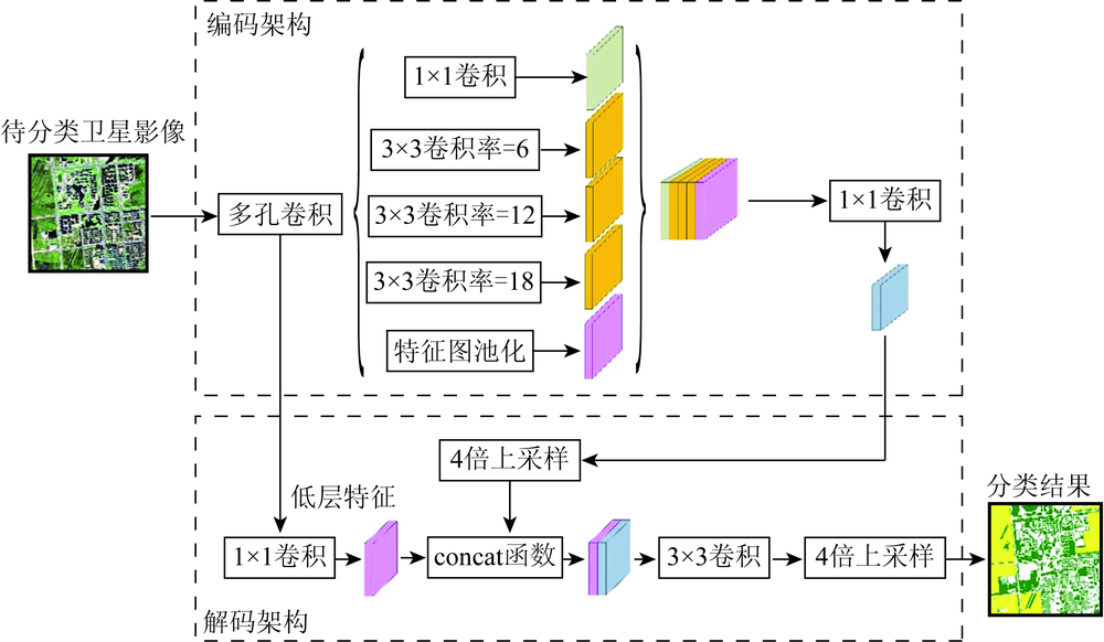
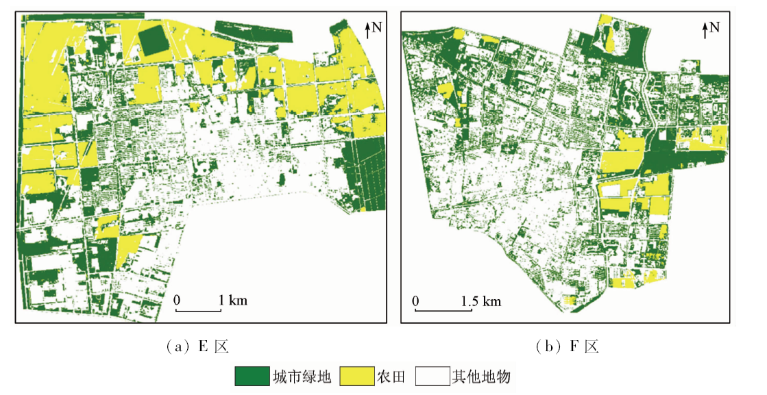
Abstract The efficient and accurate extraction of urban green space (UGS) is of great significance to land planning and construction. The application of deep learning semantic segmentation algorithm to remote sensing image classification is a new exploration in recent years. This paper describes a multilevel architecture which targets UGS extraction from GF-2 imagery based on DeepLabv3plus semantic segmentation network. Through Atrous Spatial Pyramid Pooling (ASPP) and other modules of the network, high-level features are extracted, and data set creation, model training, urban green space extraction and accuracy evaluation are completed relying on the architecture. The accuracy evaluation shows that DeepLabv3plus outperforms the traditional machine learning methods, such as maximum likelihood (ML), support vector machine (SVM), random forest (RF) and other four semantic segmentation networks (PspNet, SegNet, U-Net and DeepLabv2), allowing us to better extract UGS, especially exclude interference of farmland. Through accuracy evaluation, the proposed architecture reaches an acceptable accuracy, with overall accuracy being 91.02% and F Score being 0.86. Furthermore, the authors also explored the portability of the method by applying the model to another city. Overall, the automatic architecture in this paper is capable of excluding farmland pixels'interference and extracting UGS accurately from RGB high spatial RS images, which provides reference for urban planning and managements.
|
| Keywords
urban green space
DeepLab
semantic segmentation
deep learning
GF-2
|
|
|
|
Corresponding Authors:
Weihua SHI
E-mail: 20143262@qq.com
|
|
Issue Date: 18 June 2020
|
|
|
| [1] |
刘小平, 邓孺孺, 彭晓鹃. 城市绿地遥感信息自动提取研究——以广州市为例[J]. 地域研究与开发, 2005,24(5):110-113.
|
| [1] |
Liu X P, Deng R R, Peng X J. An automatic extraction model of urban greenbelt remote sensing image:A study on Guangzhou City[J]. Areal Research and Development, 2005,24(5):110-113.
|
| [2] |
程灿然. 基于GF-1卫星影像的城市绿地信息提取与景观格局研究[D]. 兰州:兰州交通大学, 2017.
|
| [2] |
Cheng C R. Information extraction and landscape pattern of urban greenbelt based on GF-1 satellite image:A case study of Lanzhou[D]. Lanzhou:Lanzhou Jiaotong University, 2017.
|
| [3] |
Liu C, Guo Z, Fu N. Applying a new integrated classification method to monitor shifting mangrove wetlands [C]// International Conference on Multimedia Technology. 2010.
|
| [4] |
Zylshal, Sulma S, Yulianto F,et al.A support vector machine object-based image analysis approach on urban green space extraction using Pleiades-1A imagery[J]. Modeling Earth Systems and Environment, 2016,2(2):54.
|
| [5] |
Xu L, Ming D, Zhou W, et al. Farmland extraction from high spatial resolution remote sensing images based on stratified scale pre-estimation[J]. Remote Sensing, 2019,11, 108.
|
| [6] |
Zujovic J, Pappas T N, Neuhoff D L. Structural texture similarity metrics for image analysis and retrieval[J]. IEEE Transactions on Image Processing, 2013,22(7):2545-2558.
|
| [7] |
Durduran S S. Automatic classification of high resolution land cover using a new data weighting procedure:The combination of K-means clustering algorithm and central tendency measures(KMC-CTM)[J]. Applied Soft Computing, 2015,35(1):136-150.
|
| [8] |
Gidaris S, Komodakis N. Object detection via a multi-region and semantic segmentation-aware CNN model [C]// IEEE International Conference on Computer Vision.IEEE, 2015.
|
| [9] |
Marmanis D, Wegner J D, Galliani S, et al. Semantic segmentation of aerial images with an ensemble of CNSS [C]// ISPRS Congress. 2016.
|
| [10] |
Long J, Shelhamer E, Darrell T. Fully convolutional networks for semantic segmentation[J]. IEEE Transactions on Pattern Analysis and Machine Intelligence, 2014,39(4):640-651.
|
| [11] |
Zheng S, Jayasumana S, Romera-Paredes B, et al. Conditional random fields as recurrent neural networks [C]// IEEE International Conference on Computer Vision(ICCV).IEEE, 2015.
|
| [12] |
Badrinarayanan V, Kendall A, Cipolla R. SegNet:A deep convolutional encoder-decoder architecture for image segmentation [C]// IEEE Transactions on Pattern Analysis and Machine Intelligence.IEEE, 2017,39(12):2481-2495.
|
| [13] |
Zhao H S, Shi J P, Qi X J, et al.Pyramid scene parsing network[EB/OL].(2017-04-27)[2019-07-19]. https://arxiv.org/abs/1612.01105.
url: https://arxiv.org/abs/1612.01105
|
| [14] |
Ronneberger O, Fischer P, Brox T. U-Net:Convolutional networks for biomedical image segmentation [C]// International Conference on Medical Image Computing and Computer-Assisted Intervention. 2015: 234-241.
|
| [15] |
Chen L C, Papandreou G, Kokkinos I, et al. Semantic image segmentation with deep convolutional nets and fully connected CRFs[J].Computer Science, 2014(4):357-361.
|
| [16] |
陈天华, 郑司群, 于峻川. 采用改进DeepLab网络的遥感图像分割[J]. 测控技术, 2018,37(11):34-39.
|
| [16] |
Chen T H, Zheng S Q, Yu J C. Remote sensing image segmentation based on improved DeepLab network[J]. Measurement and Control Technology, 2018,37(11):34-39.
|
| [17] |
Wang Y, Sun S, Yu J, et al.Skin lesion segmentation using atrous convolution via DeepLabv3[EB/OL].(2018-06-24)[2019-07-19]. https://arxiv.org/abs/1807.08891.
url: https://arxiv.org/abs/1807.08891
|
| [18] |
King A, Bhandarkar S M, Hopkinson B M. A comparison of deep learning methods for semantic segmentation of coral reef survey images [C]// 2018 IEEE/CVF Conference on Computer Vision and Pattern Recognition Workshops(CVPRW).IEEE, 2018.
|
| [19] |
Herranz-Perdiguero C, Redondo-Cabrera C, López-Sastre R J. In pixels we trust:From pixel labeling to object localization and scene categorization[EB/OL] .(2018-06-19)[2019-07-19]. https://arxiv.org/abs/1807.07284.
url: https://arxiv.org/abs/1807.07284
|
| [20] |
Chen Y K, Meng G F, Zhang Q, et al.Reinforced evolutionary neural architecture search[EB/OL].(2019-04-10)[2019-07-19]. https://arxiv.org/abs/1808.00193.
url: https://arxiv.org/abs/1808.00193
|
| [21] |
Chen L C, Papandreou G, Kokkinos I, et al. DeepLab:Semantic image segmentation with deep convolutional nets, atrous convolution,and fully connected CRFs[J]. IEEE Transactions on Pattern Analysis and Machine Intelligence, 2018,40(4):834-848.
|
| [22] |
Chen L C, Papandreou G, Schroff F, et al.Rethinking atrous convolution for semantic image segmentation[EB/OL].(2017-05-12)[2019-07-19]. https://arxiv.org/abs/1706.05587.
url: https://arxiv.org/abs/1706.05587
|
| [23] |
Chen L C, Zhu Y, Papandreou G, et al.Encoder-decoder with atrous separable convolution for semantic image segmentation[EB/OL].(2018-08-22)[2019-07-19]. https://arxiv.org/abs/1802.02611v1.
url: https://arxiv.org/abs/1802.02611v1
|
| [24] |
潘腾, 关晖, 贺玮. “高分二号”卫星遥感技术[J]. 航天返回与遥感, 2015,36(4):16-24.
|
| [24] |
Pan T, Guan H, He W. GF-2 satellite remote sensing technology[J]. Spacecraft Recovery and Remote Sensing, 2015,36(4):16-24.
|
| [25] |
杨建宇, 周振旭, 杜贞容, 等. 基于SegNet语义模型的高分辨率遥感影像农村建设用地提取[J]. 农业工程学报, 2019,35(5):251-258.
url: http://www.tcsae.org/nygcxb/ch/reader/view_abstract.aspx?file_no=20190531&flag=1
|
| [25] |
Yang J Y, Zhou Z X, Du Z R, et al. Rural construction land extraction from high spatial resolution remote sensing image based on SegNet semantic segmentation model[J]. Transactions of the Chinese Society of Agricultural Engineering, 2019,35(5):251-258.
|
| [26] |
陈杰, 陈铁桥, 梅小明, 等. 基于最优尺度选择的高分辨率遥感影像丘陵农田提取[J]. 农业工程学报, 2014,30(5):99-107.
url: http://www.tcsae.org/nygcxb/ch/reader/view_abstract.aspx?file_no=20140513&flag=1
|
| [26] |
Chen J, Chen T Q, Mei X M, et al. Hilly farmland extraction from high resolution remote sensing imagery based on optimal scale selection[J]. Transactions of the Chinese Society of Agricultural Engineering, 2014,30(5):99-107.
url: http://www.tcsae.org/nygcxb/ch/reader/view_abstract.aspx?file_no=20140513&flag=1
|
|
Viewed |
|
|
|
Full text
|
|
|
|
|
Abstract
|
|
|
|
|
Cited |
|
|
|
|
| |
Shared |
|
|
|
|
| |
Discussed |
|
|
|
|
 2020,
Vol. 32
2020,
Vol. 32