|
|
 |
|

|
|
|
Classification of tropical natural forests in Hainan Island based on multi-temporal Landsat8 remote sensing images |
ZHU Qi1,2( ), GUO Huadong1,2, ZHANG Lu1,2,3(), LIANG Dong1,2, LIU Xuting1,2, WAN Xiangxing4 ), GUO Huadong1,2, ZHANG Lu1,2,3(), LIANG Dong1,2, LIU Xuting1,2, WAN Xiangxing4 |
1. Key Laboratory of Digital Earth Science, Aerospace Information Research Institute, Chinese Academy of Sciences, Beijing 100094, China
2. University of Chinese Academy of Sciences, Beijing 100049, China
3. Sanya Institute of Remote Sensing, Sanya 572029, China
4. Institute of Forest Resources Information Technique, Chinese Academy of Forestry, Beijing 100091, China |
|
|
|
|
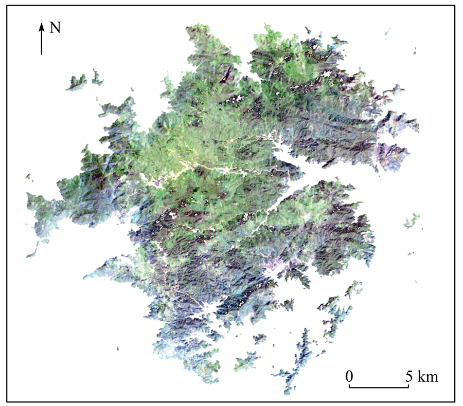
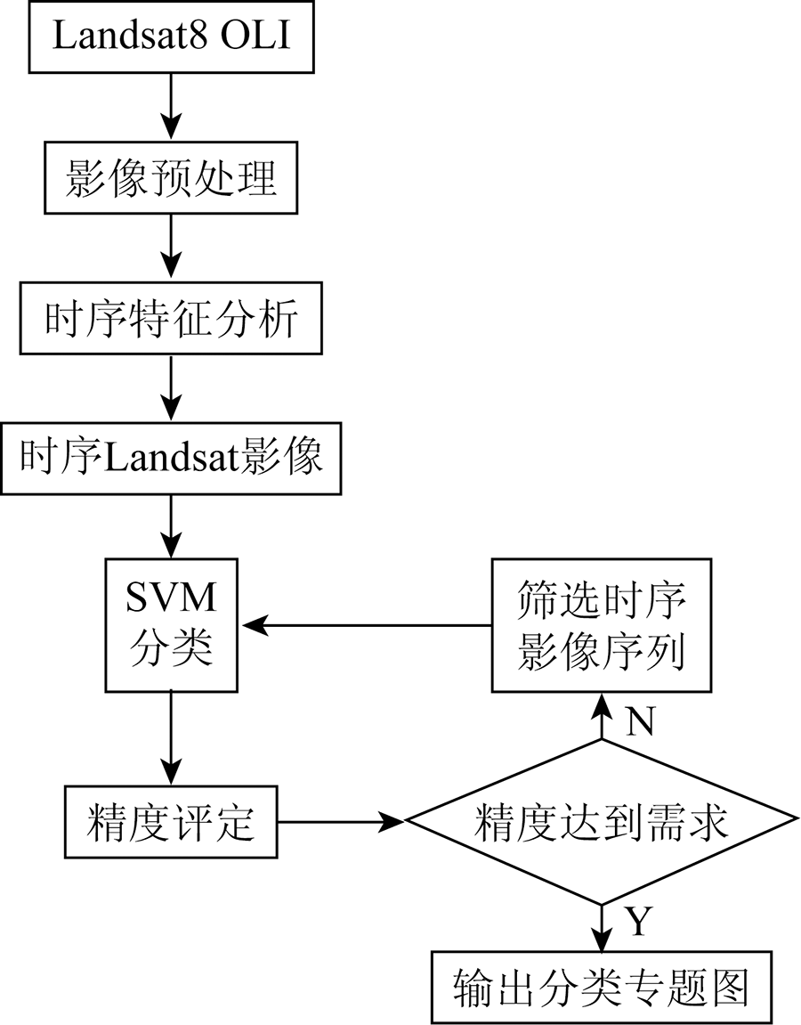
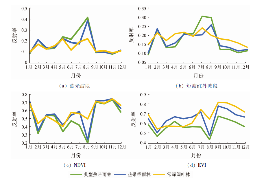
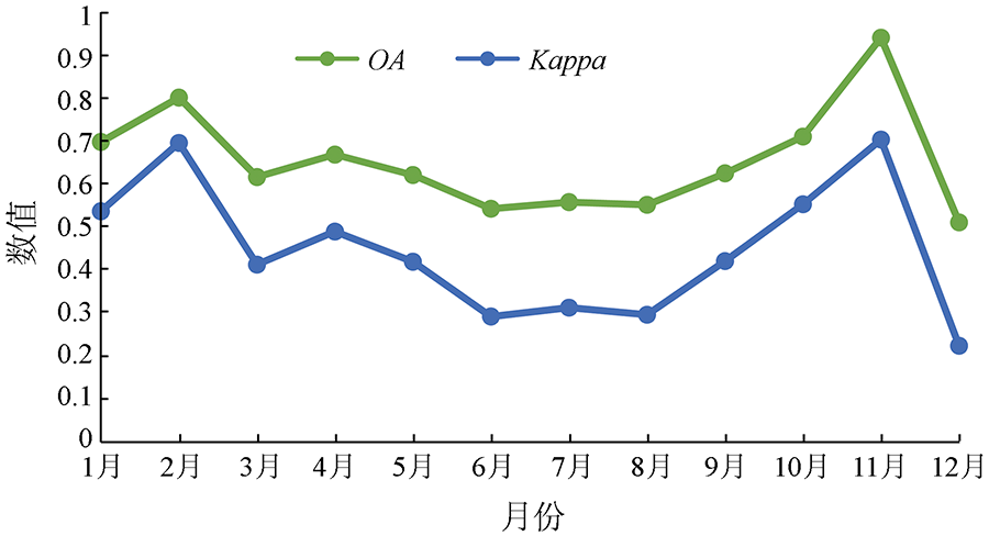
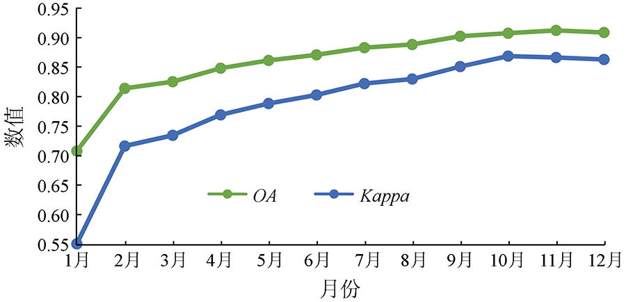
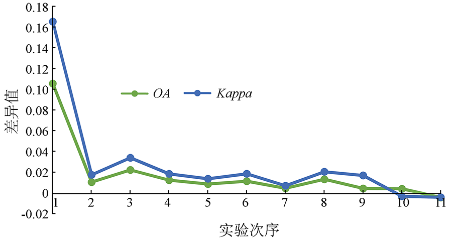
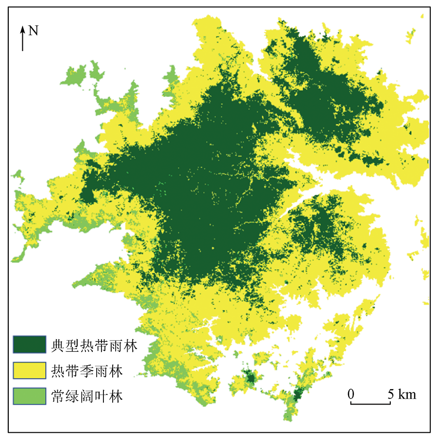
Abstract Tropical forests play a vital role in biodiversity conservation and research on global climate change. However, the complexity and diversity of vegetation types pose challenges to the fine remote sensing-based classification of tropical forests. The classification of tropical forests in the Jianfengling area, Hainan Province was analyzed using the multi-temporal Landsat8 data of the Google Earth Engine (GEE) platform. Based on the analysis of the impacts of the size and combination of multi-temporal data on the classification accuracy, this study proposed a classification method based on multi-temporal Landsat8 images for the vegetation type groups of tropical natural forests, such as typical tropical rain forest, tropical monsoon forest, and evergreen broad-leaved forests. The results are as follows. ① The classification accuracy of tropical natural forests was significantly improved as the size of multi-temporal data increased. The classification accuracy of the vegetation type groups of natural forests in Hainan Island reached 91%. ② When the multi-temporal data reached a certain size, the classification accuracy tended to be stable. Different combinations of multi-temporal data can improve the classification accuracy of tropical forests, especially when the classification accuracy of individual data involved was low. This finding reflects the broadness of the selection of temporal data. The proposed method, taking advantage of the temporal changes in remote sensing data, provides an effective reference for the remote sensing-based classification of tropical natural forests in Hainan Island.
|
| Keywords
classification of tropical forests
Google Earth Engine
support vector machine
temporal data
big earth data
|
|
|
|
Corresponding Authors:
ZHANG Lu
E-mail: zhuqi20@mails.ucas.ac.cn;zhanglu@aircas.ac.cn
|
|
Issue Date: 20 June 2022
|
|
|
| [1] |
Aragao L, Poulter B, Barlow J, et al. Environmental change and the carbon balance of Amazonian forests[J]. Biological Reviews, 2014, 89(4):913-931.
doi: 10.1111/brv.12088
url: https://onlinelibrary.wiley.com/doi/10.1111/brv.12088
|
| [2] |
Finer M, Babbitt B, Novoa S, et al. Future of oil and gas development in the western Amazon[J]. Environmental Research Letters, 2015, 10(2):024003.
doi: 10.1088/1748-9326/10/2/024003
url: https://iopscience.iop.org/article/10.1088/1748-9326/10/2/024003
|
| [3] |
邓燔, 陈秋波, 刘建波. 海南省热带天然林保护和补偿现状及缺陷分析[J]. 热带农业科学, 2007, 27(2):72-76.
|
| [3] |
Deng F, Chen Q B, Liu J B. Analysis of the status quo and deficiencies of the protection and compensation of tropical natural forests in Hainan Province[J]. Chinese Journal of Tropical Agriculture, 2007, 27(2):72-76.
|
| [4] |
Lawrence D, Vandecar K. Effects of tropical deforestation on climate and agriculture[J]. Nature Climate Change, 2015, 5(1):27-36.
doi: 10.1038/nclimate2430
url: https://doi.org/10.1038/nclimate2430
|
| [5] |
Kalamandeen M, Gloor E, Mitchard E, et al. Pervasive rise of small-scale deforestation in Amazonia[J]. Scientific Reports, 2018, 8(1):1-10.
|
| [6] |
陈新云, 李利伟, 刘承芳, 等. 热带原始森林类型分类和蓄积量遥感反演研究[J]. 林业资源管理, 2019, 28(2):39.
|
| [6] |
Chen X Y, Li L W, Liu C F, et al. Research on classification of tropical primeval forest types and stock volume remote sensing inversion[J]. Forest Resources Management, 2019, 28(2):39.
|
| [7] |
田庆久, 闵祥军. 植被指数研究进展[J]. 地球科学进展, 1998, 13(4):327-333.
|
| [7] |
Tian Q J, Min X J. Research progress in vegetation index[J]. Advances in Earth Science, 1998, 13(4):327-333.
|
| [8] |
Homer C, Dewitz J, Fry J, et al. Completion of the 2001 national land cover database for the counterminous United States[J]. Photogrammetric Engineering and Remote Sensing, 2007, 73(4):337.
|
| [9] |
Merchant J W. Remote sensing of the environment:An earth resource perspective[J]. Cartography and Geographic Information Science, 2000, 27(4):311.
doi: 10.1559/152304000783547768
url: http://www.tandfonline.com/doi/abs/10.1559/152304000783547768
|
| [10] |
Gómez C, White J C, Wulder M A. Optical remotely sensed time series data for land cover classification:A review[J]. ISPRS Journal of Photogrammetry and Remote Sensing, 2016, 116:55-72.
doi: 10.1016/j.isprsjprs.2016.03.008
url: https://linkinghub.elsevier.com/retrieve/pii/S0924271616000769
|
| [11] |
Jamali S, Jönsson P, Eklundh L, et al. Detecting changes in vegetation trends using time series segmentation[J]. Remote Sensing of Environment, 2015, 156:182-195.
doi: 10.1016/j.rse.2014.09.010
url: https://linkinghub.elsevier.com/retrieve/pii/S0034425714003538
|
| [12] |
Senf C, Leitão P J, Pflugmacher D, et al. Mapping land cover in complex Mediterranean landscapes using Landsat:Improved classification accuracies from integrating multi-seasonal and synthetic imagery[J]. Remote Sensing of Environment, 2015, 156:527-536.
doi: 10.1016/j.rse.2014.10.018
url: https://linkinghub.elsevier.com/retrieve/pii/S0034425714004283
|
| [13] |
Wang J, Zhao Y, Li C, et al. Mapping global land cover in 2001 and 2010 with spatial-temporal consistency at 250 m resolution[J]. ISPRS Journal of Photogrammetry and Remote Sensing, 2015, 103:38-47.
doi: 10.1016/j.isprsjprs.2014.03.007
url: https://linkinghub.elsevier.com/retrieve/pii/S0924271614000707
|
| [14] |
Shimabukuro Y E, Beuchle R, Grecchi R C, et al. Assessment of forest degradation in Brazilian Amazon due to selective logging and fires using time series of fraction images derived from Landsat ETM+ images[J]. Remote Sensing Letters, 2014, 5(9):773-782.
doi: 10.1080/2150704X.2014.967880
url: http://www.tandfonline.com/doi/abs/10.1080/2150704X.2014.967880
|
| [15] |
Pouliot D, Latifovic R, Zabcic N, et al. Development and assessment of a 250 m spatial resolution MODIS annual land cover time series (2000—2011) for the forest region of Canada derived from change-based updating[J]. Remote Sensing of Environment, 2014, 140:731-743.
doi: 10.1016/j.rse.2013.10.004
url: https://linkinghub.elsevier.com/retrieve/pii/S0034425713003726
|
| [16] |
陈焕镛. 海南植物志[M]. 北京: 科学出版社, 1964:338.
|
| [16] |
Chen H Y. Flora of Hainan[M]. Beijing: Science Press, 1964:338.
|
| [17] |
李意德. 海南岛尖峰岭热带山地雨林的群落结构特征[J]. 热带亚热带植物学报, 1997, 5(1):18-26.
|
| [17] |
Li Y D. Community structure characteristics of tropical mountain rainforest in Jianfengling Hainan Island[J]. Journal of Tropical and Subtropical Botany, 1997, 5(1):18-26.
|
| [18] |
盛大勇, 庄雪影, 许涵, 等. 尖峰岭热带山地雨林海南特有木本植物群落结构[J]. 植物生态学报, 2012, 36(9):935.
|
| [18] |
Sheng D Y, Zhuang X Y, Xu H, et al. Community structure of endemic woody plants in the tropical mountain rain forest of Jianfengling in Hainan[J]. Chinese Journal of Plant Ecology, 2012, 36(9):935.
doi: 10.3724/SP.J.1258.2012.00935
url: http://pub.chinasciencejournal.com/article/getArticleRedirect.action?doiCode=10.3724/SP.J.1258.2012.00935
|
| [19] |
Chambers J Q, Tribuzy E S, Toledo L C, et al. Respiration from a tropical forest ecosystem:Partitioning of sources and low carbon use efficiency[J]. Ecological Applications, 2004, 14(s4):72-88.
doi: 10.1890/01-6012
url: http://doi.wiley.com/10.1890/01-6012
|
| [20] |
王伯荪, 彭少麟, 郭泺, 等. 海南岛热带森林景观类型多样性[J]. 生态学报, 2007, 27(5):1690-1695.
|
| [20] |
Wang B S, Peng S L, Guo L, et al. Diversity of tropical forest landscape types in Hainan Island[J]. Acta Ecologica Sinica, 2007, 27(5):1690-1695.
doi: 10.1016/S1872-2032(07)60040-7
url: https://linkinghub.elsevier.com/retrieve/pii/S1872203207600407
|
| [21] |
Chander G, Markham B L, Helder D L. Summary of current radiometric calibration coefficients for Landsat MSS,TM,ETM+,and EO-1 ALI sensors[J]. Remote Sensing of Environment, 2009, 113(5):893-903.
doi: 10.1016/j.rse.2009.01.007
url: https://linkinghub.elsevier.com/retrieve/pii/S0034425709000169
|
| [22] |
Oreopoulos L, Wilson M J, Várnai T. Implementation on Landsat data of a simple cloud-mask algorithm developed for MODIS land bands[J]. IEEE Geoscience and Remote Sensing Letters, 2011, 8(4):597-601.
doi: 10.1109/LGRS.2010.2095409
url: http://ieeexplore.ieee.org/document/5688281/
|
| [23] |
张滔, 唐宏. 基于Google Earth Engine的京津冀2001—2015年植被覆盖变化与城镇扩张研究[J]. 遥感技术与应用, 2018, 33(4):593-599.
|
| [23] |
Zhang T, Tang H. Beijing-Tianjin-Hebei 2001—2015 based on Google Earth Engine vegetation cover change and urban expansion[J]. Remote Sensing Technology and Application, 2018, 33(4):593-599.
|
| [24] |
宋永昌. 对中国植被分类系统的认知和建议[J]. 植物生态学报, 2011, 35(8):882.
doi: 10.3724/SP.J.1258.2011.00882
|
| [24] |
Song Y C. Cognition and suggestions on China’s vegetation classification system[J]. Chinese Journal of Plant Ecology, 2011, 35(8):882.
doi: 10.3724/SP.J.1258.2011.00882
url: http://pub.chinasciencejournal.com/article/getArticleRedirect.action?doiCode=10.3724/SP.J.1258.2011.00882
|
| [25] |
Zhang L, Wan X, Sun B. Tropical natural forest classification using time-series Sentinel-1 and Landsat-8 images in Hainan Island[C]// IEEE International Geoscience and Remote Sensing Symposium, 2019:6732-6735.
|
| [26] |
Cherkassky V, Ma Y. Practical selection of SVM parameters and noise estimation for SVM regression[J]. Neural Networks, 2004, 17(1):113-126.
pmid: 14690712
|
|
Viewed |
|
|
|
Full text
|
|
|
|
|
Abstract
|
|
|
|
|
Cited |
|
|
|
|
| |
Shared |
|
|
|
|
| |
Discussed |
|
|
|
|
 2022,
Vol. 34
2022,
Vol. 34