|
|
 |
|

|
|
|
Impacts of the Syrian Civil War on vegetation |
ZENG Hui1( ), REN Huazhong1,2(), ZHU Jinshun1, GUO Jinxin1, YE Xin1, TENG Yuanjian1, NIE Jing1, QIN Qiming1,2 ), REN Huazhong1,2(), ZHU Jinshun1, GUO Jinxin1, YE Xin1, TENG Yuanjian1, NIE Jing1, QIN Qiming1,2 |
1. Institute of Remote Sensing and Geographic Information System, School of Earth and Space Sciences, Peking University, Beijing 100871, China
2. Beijing Key Laboratory of Spatial Information Integration and Its Application, Peking University, Beijing 100871, China |
|
|
|
|
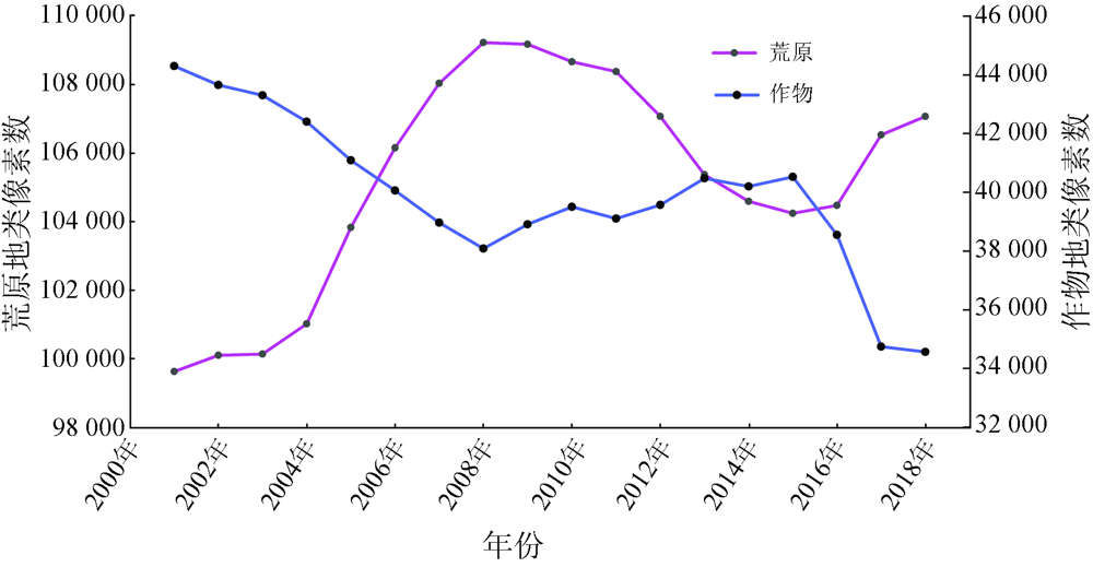
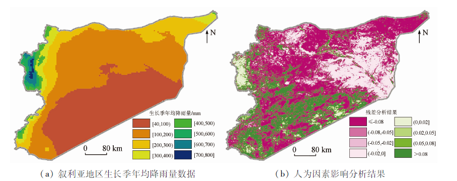
Abstract Besides numerous casualties and economic losses, wars may cause damage to the environment. Using a long time series of satellite remote sensing data from 2001 to 2018, this study explored the response of vegetation growth to the environmental changes in Syria caused by the Syrian Civil War. The results are as follows. The vegetation index significantly decreased in regions that experienced the most intense conflict in the war. The land types changed slightly from 2011 when the war started to 2015 but changed significantly from 2015 to 2018, with the grassland area decreasing by 10.08% and the crop planting area decreasing by 21.87%. This study further explored the impacts of human activities on the vegetation status, revealing that both sides of the Euphrates River in the east and their extensional areas are most significantly affected by human activities. This study discovered the negative impacts of the war on vegetation growth and can be utilized as a reference for the research and strategy formulation on food security in areas with military conflicts.
|
| Keywords
NDVI
time series
vegetation
Syrian Civil War
|
|
|
|
Corresponding Authors:
REN Huazhong
E-mail: zenghui@pku.edu.cn;renhuazhong@pku.edu.cn
|
|
Issue Date: 21 September 2022
|
|
|
| [1] |
孙红雨, 王长耀. 中国地表植被覆盖变化及其与气候因子关系──基于NOAA时间序列数据分析[J]. 遥感学报, 1998, 2(3):204-210.
|
| [1] |
Sun H Y, Wang C Y. Analysis of the vegetation cover change and the relationship between NDVI and environmental factors by using NOAA time series data[J]. Journal of Remote Sensing, 1998, 2(3):204-210.
|
| [2] |
Rouse J W, Haas R H, Schell J A, et al. Monitoring vegetation systems in the Great Plains with ERTS[J]. NASA Special Publication, 1974, 351(1974):309.
|
| [3] |
田庆久, 闵祥军. 植被指数研究进展[J]. 地球科学进展, 1998, 13(4):327-333.
|
| [3] |
Tian Q J, Min X J. Advances in study on vegetation indices[J]. Advance in Earth Sciences, 1998, 13(4):327-333.
|
| [4] |
Li X, Li D. Can night-time light images play a role in evaluating the Syrian crisis?[J]. International Journal of Remote Sensing, 2014, 35(18):6648-6661.
doi: 10.1080/01431161.2014.971469
url: https://www.tandfonline.com/doi/full/10.1080/01431161.2014.971469
|
| [5] |
Li X, Chen F, Chen X. Satellite-observed nighttime light variation as evidence for global armed conflicts[J]. IEEE Journal of Selected Topics in Applied Earth Observations and Remote Sensing, 2013, 6(5):2302-2315.
doi: 10.1109/JSTARS.2013.2241021
url: https://ieeexplore.ieee.org/document/6502753/
|
| [6] |
Huete A, Didan K, van Leeuwen W.MODIS vegetation indices[M]// Land remote sensing and global environmental change. New York: Springer, 2010:579-602.
|
| [7] |
Beck H E, McVicar T R, van Dijk A I J M. Global evaluation of four AVHRR-NDVI data sets:Intercomparison and assessment against Landsat imagery[J]. Remote Sensing of Environment, 2011, 115(10):2547-2563.
doi: 10.1016/j.rse.2011.05.012
url: https://linkinghub.elsevier.com/retrieve/pii/S0034425711001957
|
| [8] |
Huete A, Justice C, Van Leeuwen W.MODIS vegetation index(MOD13)[J]. Algorithm Theoretical Basis Document, 1999, 3(213):295-309.
|
| [9] |
Harris I, Jones P D, Osborn T J. Updated high-resolution grids of monthly climatic observations:The CRU TS3.10 Dataset[J]. International Journal of Climatology, 2014, 34(3):623-642.
doi: 10.1002/joc.3711
url: https://onlinelibrary.wiley.com/doi/10.1002/joc.3711
|
| [10] |
Fick S E, Hijmans R J. WorldClim 2:New 1-km spatial resolution climate surfaces for global land areas[J]. International Journal of Climatology, 2017, 37(12):4302-4315.
doi: 10.1002/joc.5086
url: https://onlinelibrary.wiley.com/doi/10.1002/joc.5086
|
| [11] |
柯灵红, 王正兴, 宋春桥. 青藏高原东北部 MODIS LST 时间序列重建及与台站地温比较[J]. 地理科学进展, 2011, 30(7):819-826.
|
| [11] |
Ke L H, Wang Z X, Song C Q. Reconstruction of MODIS LST time series and comparison with land surface temperature among observation stations in the northeast Qinghai-Tibet Plateau[J]. Progress in Geography, 2011, 30(7):819-826.
|
| [12] |
曹云锋, 王正兴, 邓芳萍. 3种滤波算法对 NDVI 高质量数据保真性研究[J]. 遥感技术与应用, 2010, 25(1):118-125.
|
| [12] |
Cao Y F, Wang Z X, Deng F P. Fidelity performance of three filters for high quality NDVI Time-series analysis[J]. Remote Sensing Technology and Application, 2010, 25(1):118-125.
|
| [13] |
Jönsson P, Eklundh L. TIMESAT:A program for analyzing time-series of satellite sensor data[J]. Computers and Geosciences, 2004, 30(8):833-845.
doi: 10.1016/j.cageo.2004.05.006
url: https://linkinghub.elsevier.com/retrieve/pii/S0098300404000974
|
| [14] |
Jonsson P, Eklundh L. Seasonality extraction by function fitting to time-series of satellite sensor data[J]. IEEE Transactions on Geo-science and Remote Sensing, 2002, 40(8):1824-1832.
doi: 10.1109/TGRS.2002.802519
url: http://ieeexplore.ieee.org/document/1036010/
|
| [15] |
Eklundh L, Jönsson P. TIMESAT 3.3 with seasonal trend decomposition and parallel processing software manual[R]. Sweden: Lund and Malmö University, 2017.
|
| [16] |
宋春桥, 柯灵红, 游松财. 基于 TIMESAT 的 3 种时序 NDVI 拟合方法比较研究[J]. 遥感技术与应用, 2011, 26(2):147-154.
|
| [16] |
Song C Q, Ke L H, You S C. Comparison of three NDVI time-series fitting methods based on TIMESAT:Taking the grassland in Northern Tibet as case[J]. Remote Sensing Technology and Application, 2011, 26(2):147-154.
|
| [17] |
Mann H B. Nonparametric tests against trend[J]. Econometrica:Journal of the Econometric Society, 1945:245-259.
|
| [18] |
Sen P K. Estimates of the regression coefficient based on Kendall’s tau[J]. Journal of the American Statistical Association, 1968, 63(324):1379-1389.
doi: 10.1080/01621459.1968.10480934
url: http://www.tandfonline.com/doi/abs/10.1080/01621459.1968.10480934
|
| [19] |
Gilbert R O. Statistical methods for environmental pollution monitoring[M]. New York: John Wiley and Sons, 1987.
|
| [20] |
王佃来, 刘文萍, 黄心渊. 基于 Sen+ Mann-Kendall 的北京植被变化趋势分析[J]. 计算机工程与应用, 2013, 49(5):13-17.
|
| [20] |
Wang D L, Liu W P, Huang X Y. Trend analysis in vegetation cover in Beijing based on Sen+ Mann-Kendall method[J]. Computer Engineering and Applications, 2013, 49(5):13-17.
|
| [21] |
Hurst H E. Long-term storage capacity of reservoirs[J]. Transactions of the American Society of Civil Engineers, 1951, 116(1):770-799.
doi: 10.1061/TACEAT.0006518
url: https://ascelibrary.org/doi/10.1061/TACEAT.0006518
|
| [22] |
Mandelbrot B B, Wallis J R. Robustness of the rescaled range R/S in the measurement of noncyclic long run statistical dependence[J]. Water Resources Research, 1969, 5(5):967-988.
doi: 10.1029/WR005i005p00967
url: http://doi.wiley.com/10.1029/WR005i005p00967
|
| [23] |
Evans J, Geerken R. Discrimination between climate and human-induced dryland degradation[J]. Journal of Arid Environments, 2004, 57(4):535-554.
doi: 10.1016/S0140-1963(03)00121-6
url: https://linkinghub.elsevier.com/retrieve/pii/S0140196303001216
|
| [24] |
Wessels K J, van den Bergh F, Scholes R J. Limits to detectability of land degradation by trend analysis of vegetation index data[J]. Remote Sensing of Environment, 2012, 125:10-22.
doi: 10.1016/j.rse.2012.06.022
url: https://linkinghub.elsevier.com/retrieve/pii/S0034425712002581
|
| [25] |
Abdo H G. Impacts of war in Syria on vegetation dynamics and erosion risks in Safita area,Tartous,Syria[J]. Regional Environmental Change, 2018, 18(6):1707-1719.
doi: 10.1007/s10113-018-1280-3
url: https://doi.org/10.1007/s10113-018-1280-3
|
| [26] |
Jaafar H H, Zurayk R, King C. Impact of the Syrian conflict on irrigated agriculture in the Orontes basin[J]. International Journal of Water Resources Development, 2015, 31(3):436-449.
doi: 10.1080/07900627.2015.1023892
url: https://www.tandfonline.com/doi/full/10.1080/07900627.2015.1023892
|
| [27] |
Wessels K J, Prince S D, Malherbe J. Can human-induced land degradation be distinguished from the effects of rainfall variability? A case study in South Africa[J]. Journal of Arid Environments, 2007, 68(2):271-297.
doi: 10.1016/j.jaridenv.2006.05.015
url: https://linkinghub.elsevier.com/retrieve/pii/S014019630600190X
|
| [28] |
Kelley C P, Mohtadi S, Cane M A. Climate change in the Fertile Crescent and implications of the recent Syrian drought[J]. Proceedings of the National Academy of Sciences, 2015, 112(11):3241-3246.
doi: 10.1073/pnas.1421533112
url: https://pnas.org/doi/full/10.1073/pnas.1421533112
|
|
Viewed |
|
|
|
Full text
|
|
|
|
|
Abstract
|
|
|
|
|
Cited |
|
|
|
|
| |
Shared |
|
|
|
|
| |
Discussed |
|
|
|
|
 2022,
Vol. 34
2022,
Vol. 34