|
|
|
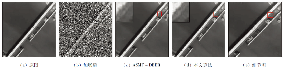
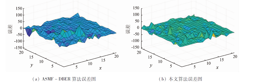
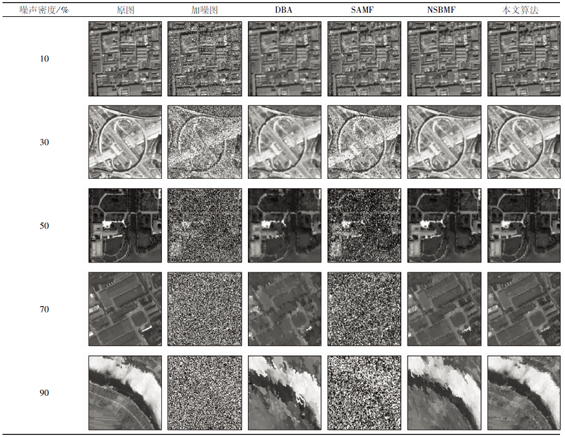
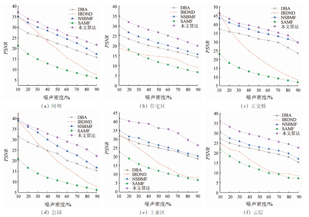
Abstract Eliminating impulse noise of high-quality remote sensing images is of great significance for applied research. It has always been a challenge to eliminate high-density impulse noise while remaining detailed information on edges in original remote sensing images. This study concluded that uncertain changes will appear when a remote sensing image is corrupted by impulse noise. Given this, an uncertainty model based on the evidence theory was constructed using multiple features of impulse noise. The BJS divergence and the reliability entropy were fused into the model to obtain new weights and a new probability assignment. Then, the classification between noise and signals was given according to fusion rules and probability transformation, thus effectively reducing the possibility of high-level conflicts. The experimental results show that the classification method proposed in this study is effective even when the noise density is up to over 90% and can well maintain detailed information on different ground objects in the denoised remote sensing images.
|
| Keywords
evidence theory
uncertainty modeling
fusion rules
highly conflict
remote sensing image
|
|
|
|
Issue Date: 21 September 2022
|
|
|
| [1] |
赵洪臣, 周兴华, 彭聪, 等. 一种去除遥感影像混合噪声的集成BM3D方法[J]. 武汉大学学报(信息科学版), 2019, 44(6):925-932.
|
| [1] |
Zhao H C, Zhou X H, Peng C et al. An integrated BM3D method for removing mixed noise in remoting sensing image[J]. Geomatics and Information Science of Wuhan University, 2019, 44(6):925-932.
|
| [2] |
汪贵平, 杜晶晶, 宋京, 等. 基于梯度倒数的无人机遥感图像融合滤波方法[J]. 科学技术与工程, 2018, 18(31):190-194.
|
| [2] |
Wang G P, Du J J, Song J, et al. A fusion filter method for unmanned aerial vehicle remote sensing image based on gradient inverse[J]. Science Technology and Engineering, 2018, 18(31):190-194.
|
| [3] |
朱建军, 周靖鸿, 周璀, 等. 一种新的去除遥感影像混合噪声组合滤波方法[J]. 武汉大学学报(信息科学版), 2017, 42(3):348-354.
|
| [3] |
Zhu J J, Zhou J H, Zhou C, et al. A new combination filtering method to removing mixed noise of remote sensing images[J]. Geomatics and Information Science of Wuhan University, 2017, 42(3):348-354.
|
| [4] |
刘帅. 基于分层稀疏学习和协同表示的高光谱图像去噪和分类[D]. 西安: 西安电子科技大学, 2016.
|
| [4] |
Liu S. Hierarchical sparse learning and collaborative representation for hyperspectral imagery restoration and classification[D]. Xi’an: Xidian University, 2016.
|
| [5] |
Srinivasan K S, Ebenezer D. A new fast and efficient decision-based algorithm for removal of high-density impulse noises[J]. IEEE Signal Processing Letters, 2007, 14(3):189-192.
doi: 10.1109/LSP.2006.884018
url: http://ieeexplore.ieee.org/document/4100656/
|
| [6] |
Jayaraj V, Ebenezer D. A new switching-based median filtering scheme and algorithmfor removal of high density salt and pepper noise in images[J]. Journal on Advances in Signal Processing, 2010(1):409-413.
|
| [7] |
Dempster A P. Upper and lower probabilities induced by a multivalued mapping[J]. The Annals of Mathematical Statistics, 1967, 38(2):325-339.
doi: 10.1214/aoms/1177698950
url: http://projecteuclid.org/euclid.aoms/1177698950
|
| [8] |
蒋雯. 邓鑫洋. D-S证据理论信息建模与应用[M]. 北京: 科学出版社, 2018.
|
| [8] |
Jiang W, Deng X Y. D-S evidence theory information modeling and application[M]. Beijing: Science Press, 2018.
|
| [9] |
童涛, 杨桄, 李昕, 等. 基于D-S证据理论的多特征融合SAR图像目标识别方法[J]. 国土资源遥感, 2013, 25(2):37-41.doi: 10.6046/gtzyyg.2013.02.07.
doi: 10.6046/gtzyyg.2013.02.07
|
| [9] |
Tong T, Yang G, Li X, et al. Recognition method of multi-feature fusion based on D-S evidence theory in SAR image[J]. Remote Sensing for Land and Resources, 2013, 25(2):37-41.doi: 10.6046/gtzyyg.2013.02.07.
doi: 10.6046/gtzyyg.2013.02.07
|
| [10] |
李华朋, 张树清, 孙妍. 证据理论结合遥感分类数据能力定量评价研究[J]. 国土资源遥感, 2011, 23(1):26-32.doi: 10.6046/gtzyyg.2011.01.05.
doi: 10.6046/gtzyyg.2011.01.05
|
| [10] |
Li H P, Zhang S Q, Sun Y. The quantitative evaluation of remoting sensing data for supervised evidential classification[J]. Remote sensing for Land and Resources, 2011, 23(1):26-32.doi: 10.6046/gtzyyg.2011.01.05.
doi: 10.6046/gtzyyg.2011.01.05
|
| [11] |
Zhang Z, Han D, Dezert J, et al. A new adaptive switching median filter for impulse noise reduction with predetection based on evidential reasoning[J]. Signal Processing, 2018(147):173-189.
|
| [12] |
Ng P E, Ma K. A switching median filter with boundary discriminative noise detection for extremely corrupted images[J]. IEEE Transactions on Image Processing, 2006, 15(6):1506-1516.
doi: 10.1109/TIP.2005.871129
url: http://ieeexplore.ieee.org/document/1632204/
|
| [13] |
Han D, Dezert J, Duan Z. Evaluation of probability transformations of belief functions fordecision making[J]. IEEE Transactions on Systems,Man,and Cybernetics, 2016, 46(1):93-108.
|
| [14] |
Irpino R V. Dynamic clustering of interval data using a wasserstein based distance[J]. Pattern Recognition Letter, 2008, 29(11):1648-1658.
doi: 10.1016/j.patrec.2008.04.008
url: https://linkinghub.elsevier.com/retrieve/pii/S0167865508001396
|
| [15] |
钱晓亮, 郭雷, 余博. 基于目标尺度的自适应高斯滤波[J]. 计算机工程与应用, 2010, 46(12):14-16.
|
| [15] |
Qian X L, Guo L, Yu B. Adaptive Gaussian filter based on object scale[J]. Computer Engineering and Applications, 2010, 46(12):14-16.
|
| [16] |
Xiao F. Multi-sensor data fusion based on the belief divergence measure of evidencesand the belief entropy[J]. Information Fusion, 2019,(46):23-32.
|
| [17] |
Deng Y. Deng entropy[J]. Chaos,Solitons & Fractals, 2016(91):549-553.
|
| [18] |
Jafar I F, AlNa’mneh R A, Darabkh K A. Efficient improvements on the BDND filtering algorithm for the removal of high-density impulse noise[J]. IEEE Transactios on Image Processing, 2013, 22(3):1223-1232.
|
| [19] |
Zhao B, Zhong Y, Xia G S, et al. Dirichlet-derived multiple topic scene classification model fusing heterogeneous features for high spatial resolution remote sensing imagery[J]. IEEE Transactions on Geoscience and Remote Sensing, 2016, 54(4):2108-2123.
doi: 10.1109/TGRS.2015.2496185
url: http://ieeexplore.ieee.org/document/7329997/
|
| [20] |
Zhao B, Zhong Y, Zhang L, et al. The fisher kernel coding framework for high spatial resolution scene classification[J]. Remote Sensing, 2016, 8(2):157-176.
doi: 10.3390/rs8020157
url: http://www.mdpi.com/2072-4292/8/2/157
|
| [21] |
Zhu Q, Zhong Y, Zhao B, et al. Bag-of-visual-words scene classifier with local and global features for high spatial resolution remote sensing imagery[J]. IEEE Geoscience and Remote Sensing Letters, 2016, 13(6):747-751.
doi: 10.1109/LGRS.2015.2513443
url: http://ieeexplore.ieee.org/document/7466064/
|
| [22] |
Haidi I, Nicholas S P K, Theam F N. Simple adaptive median filter for the removal of impulse noise from highly corrupted images[J]. IEEE Transactions on Consumer Electronics, 2008, 544(4):1920-1927.
|
|
Viewed |
|
|
|
Full text
|
|
|
|
|
Abstract
|
|
|
|
|
Cited |
|
|
|
|
| |
Shared |
|
|
|
|
| |
Discussed |
|
|
|
|
 2022,
Vol. 34
2022,
Vol. 34
 ), ZHAO Fashun1, LIU Yanbin2