|
|
 |
|

|
|
|
A method for extracting information on coastal aquacultural ponds from remote sensing images based on a U2-Net deep learning model |
WANG Jianqiang1( ), ZOU Zhaohui2(), LIU Rongbo3, LIU Zhisong2 ), ZOU Zhaohui2(), LIU Rongbo3, LIU Zhisong2 |
1. Zhejiang Institute of Hydrogeology and Engineering Geology, Ningbo 315012, China
2. School of Information Engineering, Zhejiang Ocean University, Zhoushan 316022, China
3. Weifang Key Laboratory of Coastal Groundwater and Geological Environmental Protection and Restoration, Weifang 261021, China |
|
|
|
|
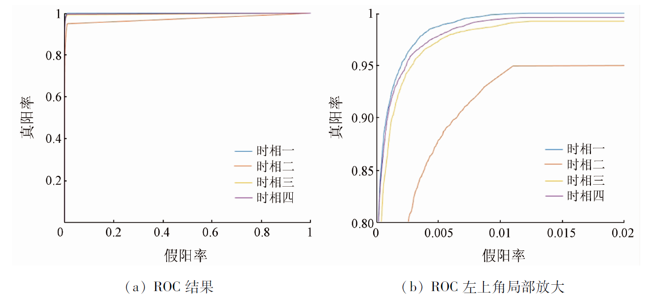
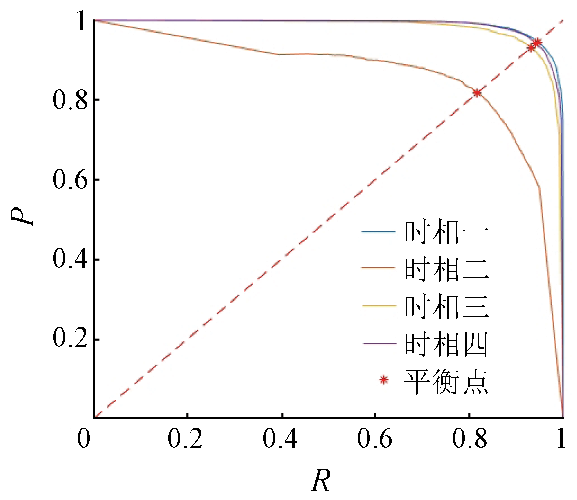
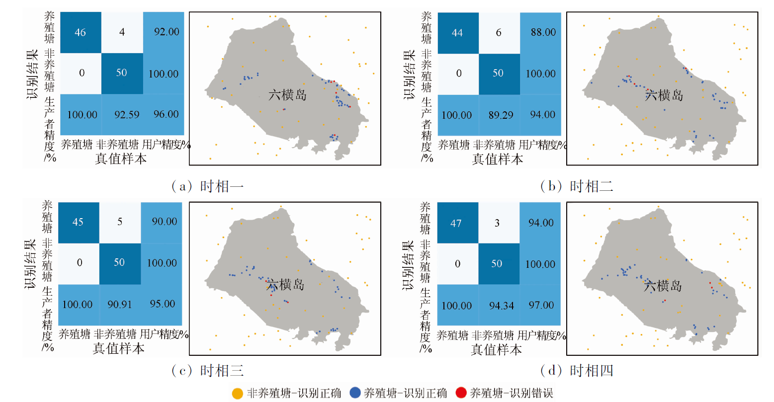
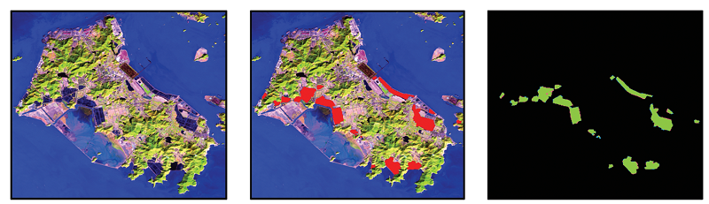
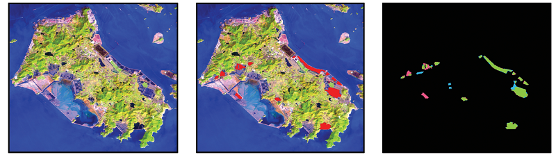
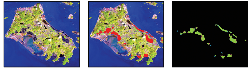
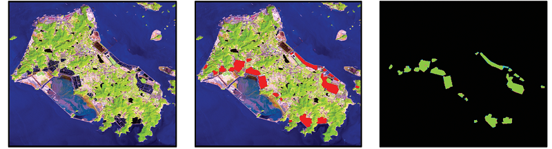
Abstract Conventional information extraction methods for aquacultural ponds frequently yield blurred boundaries and low accuracy due to the effect of different objects with the same spectrum in complex geographical environments of offshore and coastal areas. This study proposed a method for extracting information on coastal aquacultural ponds from remote sensing images based on the U2-Net deep learning model. First, an appropriate band combination method was selected to distinguish aquacultural ponds from other surface features through preprocessing of remote sensing images. Samples were then prepared through visual interpretation. Subsequently, the U2-Net model was trained, and information on coastal aquacultural ponds extracted. Finally, the scopes of aquacultural ponds were determined using the local optimum method. The experimental results show that the method proposed in this study yielded the average overall accuracy of 95.50%, with the average Kappa coefficient, recall, and F-value of 0.91, 91.45%, and 91.01%, respectively. Furthermore, 19 ponds were extracted, with a total area of 9.79 km2. The average accuracies of the number and area of aquacultural ponds were 94.06% and 93.18%, respectively. The method proposed in this study allows for quick and accurate mapping of coastal aquacultural ponds, thus providing technical support for marine resource management and sustainable development.
|
| Keywords
U2-Net
remote sensing image
aquaculture pond
complex marine environment
|
|
|
|
Issue Date: 19 September 2023
|
|
|
| [1] |
联合国粮食及农业组织. 2020年世界渔业和水产养殖状况:可持续发展在行动[M]. 罗马: 联合国粮食及农业组织, 2020.
|
| [1] |
Food and Agriculture Organization of the United Nations. The state of world fisheries and aquaculture 2020. Sustainability in action[M]. Rome: Food and Agriculture Organization of the United Nations, 2020.
|
| [2] |
吴荔生, 杨圣云. 试论养殖水域生态系统结构优化与管理[J]. 海洋科学, 2002, 26(7):15-17.
|
| [2] |
Wu L S, Yang S Y. Study on the structure optimization and management of aquaculture water ecosystem[J]. Marine Science, 2022, 26(7):15-17.
|
| [3] |
董金玮, 吴文斌, 黄健熙, 等. 农业土地利用遥感信息提取的研究进展与展望[J]. 地球信息科学学报, 2020, 22(4):772-783.
doi: 10.12082/dqxxkx.2020.200192
|
| [3] |
Dong J W, Wu W B, Huang J X, et al. State of the art and perspective of agricultural land use remote sensing information extraction[J]. Journal of Geo-Information Science, 2020, 22(4):772-783.
|
| [4] |
Marco O, Kersten C, Claudia K. Large-scale assessment of coastal aquaculture ponds with Sentinel-1 time series data[J]. Remote Sensing, 2017, 9(440):1-23.
|
| [5] |
舒弥, 杜世宏. 国土调查遥感40年进展与挑战[J]. 地球信息科学学报, 2022, 24(4):597-616.
doi: 10.12082/dqxxkx.2022.210512
|
| [5] |
Shu M, Du S H. Forty years’ progress andchallenges of remote sensing in national land survey[J]. Journal of Geo-Information Science, 2022, 24(4):597-616.
|
| [6] |
Mcfeeters S K. The use of the normalized difference water index (NDWI) in the delineation of open water features[J]. International Journal of Remote Sensing, 1996, 17(7):1425-1432.
doi: 10.1080/01431169608948714
url: https://www.tandfonline.com/doi/full/10.1080/01431169608948714
|
| [7] |
徐涵秋. 利用改进的归一化差异水体指数(MNDWI)提取水体信息的研究[J]. 遥感学报, 2005, 9(5):589-595.
|
| [7] |
Xu H Q. A study on information extraction of water body with the modified normalized difference water index (MNDWI)[J]. Journal of Remote Sensing, 2005, 9(5):589-595.
|
| [8] |
葛云峰, 夏丁, 唐辉明, 等. 基于三维激光扫描技术的岩体结构面智能识别与信息提取[J]. 岩石力学与工程学报, 2017, 36(12):3050-3061.
|
| [8] |
Ge Y F, Xia D, Tang H M, et al. Intelligent identification and extraction of geometric properties of rock discontinuities based on terrestrial laser scanning[J]. Chinese Journal of Rock Mechanics and Engineering, 2017, 36(12):3050-3061.
|
| [9] |
Cusano C, Napoletano P, Schettini R. Remote sensing image classification exploiting multiple kernel learning[J]. IEEE Geoscience and Remote Sensing Letters, 2015, 12(11):2331-2335.
doi: 10.1109/LGRS.2015.2476365
url: http://ieeexplore.ieee.org/document/7277007/
|
| [10] |
马玥, 姜琦刚, 孟治国, 等. 基于随机森林算法的农耕区土地利用分类研究[J]. 农业机械学报, 2016, 47(1):297-303.
|
| [10] |
Ma Y, Jiang Q G, Meng Z G, et al. Classification of land use in farming area based on random forest algorithm[J]. Transactions of the Chinese Society for Agricultural Machinery, 2016, 47(1):297-303.
|
| [11] |
代晶晶, 吴亚楠, 王登红, 等. 基于面向对象分类的稀土开采区遥感信息提取方法研究[J]. 地球学报, 2018, 39(1):111-118.
|
| [11] |
Dai J J, Wu Y N, Wang D H, et al. Object-oriented classification for the extraction of remote sensing information in rare earth mining areas[J]. Acta Geoscientica Sinica, 2018, 39(1):111-118.
|
| [12] |
代晓丽, 刘世峰, 宫大庆. 基于NLP的文本相似度检测方法[J]. 通信学报, 2021, 42(10):173-181.
doi: 10.11959/j.issn.1000-436x.2021192
|
| [12] |
Dai X L, Liu S F, Gong D Q. Text similarity detection method based on NLP[J]. Journal on Communications, 2021, 42(10):173-181.
doi: 10.11959/j.issn.1000-436x.2021192
|
| [13] |
冯龙锋, 陈英, 周滔辉, 等. CT图像肺及肺病变区域分割方法综述[J]. 中国图象图形学报, 2022, 27(3):722-749.
|
| [13] |
Feng L F, Chen Y, Zhou T H, et al. Review of human lung and lung lesion regions segmentation methods based on CT images[J]. Journal of Image and Graphics, 2022, 27(3):722-749.
|
| [14] |
柯丽娜, 翟宇宁, 范剑超. 深度边缘光谱U-Net海水网箱养殖信息提取[J]. 海洋学报, 2022, 44(2):132-142.
|
| [14] |
Ke L N, Zhai Y N, Fan J C. Marine cage aquaculture information extraction based on deep edge spectral U-Net[J]. Haiyang Xuebao, 2022, 44(2):132-142.
|
| [15] |
郑智腾, 范海生, 王洁, 等. 改进型双支网络模型的遥感海水网箱养殖区智能提取方法[J]. 国土资源遥感, 2020, 32(4):120-129.doi:10.6046/gtzyyg.2020.04.17.
doi: 10.6046/gtzyyg.2020.04.17
|
| [15] |
Zheng Z T, Fan H S, Wang J, et al. An improved double-branch network method for intelligently extracting marine cage culture area[J]. Remote Sensing for Land and Resources, 2020, 32(4):120-129.doi:10.6046/gtzyyg.2020.04.17.
doi: 10.6046/gtzyyg.2020.04.17
|
| [16] |
武易天, 陈甫, 马勇, 等. 基于Landsat8数据的近海养殖区自动提取方法研究[J]. 国土资源遥感, 2018, 30(3):96-105.doi:10.6046/gtzyyg.2018.03.14.
doi: 10.6046/gtzyyg.2018.03.14
|
| [16] |
Wu Y T, Chen F, Ma Y, et al. Research on automatic extraction method for coastal aquaculture area using Landsat8 data[J]. Remote Sensing for Land and Resources, 2018, 30(3):96-105.doi:10.6046/gtzyyg.2018.03.14.
doi: 10.6046/gtzyyg.2018.03.14
|
| [17] |
刘岳明, 杨晓梅, 王志华, 等. 基于深度学习RCF模型的三都澳筏式养殖区提取研究[J]. 海洋学报, 2019, 41(4):119-130.
|
| [17] |
Liu Y M, Yang X M, Wang Z H, et al. Extracting raft aquaculture areas in Sanduao from high-resolution remote sensing images using RCF[J]. Haiyang Xuebao, 2019, 41(4):119-130.
|
| [18] |
苟杰松, 蒋怡, 李宗南, 等. 基于Deeplabv3+模型的成都平原水产养殖水体信息提取[J]. 中国农机化学报, 2021, 42(3):105-112.
doi: 10.13733/j.jcam.issn.2095-5553.2021.03.015
|
| [18] |
Gou J S, Jiang Y, Li Z N, et al. Aquaculture water body information extraction in the Chengdu plain based on Deeplabv3+ model[J]. Journal of Chinese Agricultural Mechanization, 2021, 42(3):105-112.
|
| [19] |
文可, 姚焕玫, 黄以, 等. 基于GEE的广西北部湾沿海水产养殖池塘遥感提取[J]. 农业工程学报, 2021, 37(12):280-288.
|
| [19] |
Wen K, Yao H M, Huang Y, et al. Remote sensing image extraction for coastal aquaculture ponds in the Guangxi Beibu Gulf based on Google Earth Engine[J]. Transactions of the Chinese Society of Agricultural Engineering, 2021, 37(12):280-288.
|
| [20] |
柳崇斌, 徐佳, 王冬梅, 等. 基于GF-3全极化SAR影像多特征优选的水产养殖塘提取[J]. 农业工程学报, 2022, 38(4):206-214.
|
| [20] |
Liu C B, Xu J, Wang D M, et al. Extracting aquaculture pond using multi-feature optimization of GF-3 PolSAR imagery[J]. Transactions of the Chinese Society of Agricultural Engineering, 2022, 38(4):206-214.
|
| [21] |
李连伟, 张源榆, 岳增友, 等. 基于全卷积网络模型的高分遥感影像内陆网箱养殖区提取[J]. 山东科学, 2022, 35(2):1-10.
doi: 10.3976/j.issn.1002-4026.2022.02.001
|
| [21] |
Li L W, Zhang Y Y, Yue Z Y, et al. Extracting inland cage aquacultural areas from high-resolution remote sensing images using full convolutional networks model[J]. Shandong Science, 2022, 35(2):1-10.
|
| [22] |
Mei H, Ji G P, Wei Z, et al. Camouflaged object segmentation with distraction mining[C]// Proceedings of the IEEE/CVF Conference on Computer Vision and Pattern Recognition, 2021:8772-8781.
|
| [23] |
Han J, Ding J, Xue N, et al. Redet:A rotation-equivariant detector for aerial object detection[C]// Proceedings of the IEEE/CVF Conference on Computer Vision and Pattern Recognition, 2021:2786-2795.
|
| [24] |
Fang Z, Ren J, Sun H, et al. SAFDet:A semi-anchor-free detector for effective detection of oriented objects in aerial images[J]. Remote Sensing, 2020, 12(19):3225.
doi: 10.3390/rs12193225
url: https://www.mdpi.com/2072-4292/12/19/3225
|
| [25] |
Zeng Z, Wang D, Tan W, et al. RCSANet:A full convolutional network for extracting inland aquaculture ponds from high-spatial-resolution images[J]. Remote Sensing, 2020(1):92.
|
| [26] |
陈超, 陈慧欣, 陈东, 等. 舟山群岛海岸线遥感信息提取及时空演变分析[J]. 国土资源遥感, 2021, 33(2):141-152.doi:10.6046/gtzyyg.2020248.
doi: 10.6046/gtzyyg.2020248
|
| [26] |
Chen C, Chen H X, Chen D, et al. Coastline extraction and spatial-temporal variations using remote sensing technology in Zhoushan Islands[J]. Remote Sensing for Land and Resource, 2021, 33(2):141-152.doi:10.6046/gtzyyg.2020248.
doi: 10.6046/gtzyyg.2020248
|
| [27] |
Wang L, Chen C, Xie F, et al. Estimation of the value of regional ecosystem services of an arvhipelago using satellite remote sensing technology:A case study of Zhoushan Archipelago,China[J]. International Journal of Applied Earth Observation and Geoinformation, 2021(105):102616.
|
| [28] |
USGS. Landsat8,Landsat Missions[EB/OL]. https://www.usgs.gov/landsat-missions/landsat-8.
url: https://www.usgs.gov/landsat-missions/landsat-8
|
| [29] |
Zhang P, Wang D, Lu H, et al. Learning uncertain convolutional features for accurate saliency detection[C]// Proceedings of the IEEE International Conference on Computer Vision, 2017:212-221.
|
| [30] |
Deng Z, Hu X, Zhu L, et al. R3net:Recurrent residual refinement network for saliency detection[C]// Proceedings of the 27th International Joint Conference on Artificial Intelligence.Menlo Park,CA,USA: AAAI Press, 2018:684-690.
|
| [31] |
Chen S, Tan X, Wang B, et al. Reverse attention for salient object detection[C]// Proceedings of the European Conference on Computer Vision (ECCV), 2018:234-250.
|
| [32] |
Zhang J, Liang Q W, Guo Q Q, et al. R2Net:Residual refinement network for salient object detection[J]. Image and Vision Computing, 2022(120):104423.
|
| [33] |
Zeng Y, Zhuge Y, Lu H, et al. Multi-source weak supervision for saliency detection[C]// Proceedings of the IEEE/CVF Conference on Computer Vision and Pattern Recognition, 2019:6074-6083.
|
| [34] |
Ronneberger O, Fischer P, Brox T. U-Net:Convolutional networks for biomedical image segmentation[C]// International Conference on Medical Image Computing and Computer-Assisted Intervention.Springer,Cham, 2015:234-241.
|
| [35] |
Qin X, Zhang Z, Huang C, et al. U2-Net:Going deeper with nested U-structure for salient object detection[J]. Pattern Recognition, 2020(106):107404.
|
|
Viewed |
|
|
|
Full text
|
|
|
|
|
Abstract
|
|
|
|
|
Cited |
|
|
|
|
| |
Shared |
|
|
|
|
| |
Discussed |
|
|
|
|
 2023,
Vol. 35
2023,
Vol. 35