|
|
 |
|

|
|
|
Mask R-CNN-based intelligent identification of sparse woods from remote sensing images |
DIAO Mingguang1( ), LIU Yong1, GUO Ningbo1, LI Wenji2, JIANG Jikang1, WANG Yunxiao1 ), LIU Yong1, GUO Ningbo1, LI Wenji2, JIANG Jikang1, WANG Yunxiao1 |
1. School of Information Engineering, China University of Geosciences (Beijing), Beijing 100083, China
2. China Aero Geophysical Survey and Remote Sensing Center for Natural Resources, Beijing 100083, China |
|
|
|
|
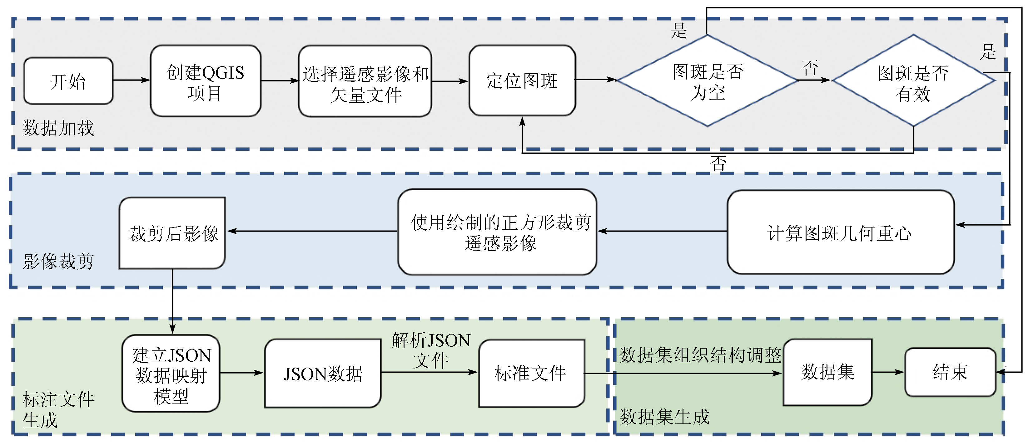
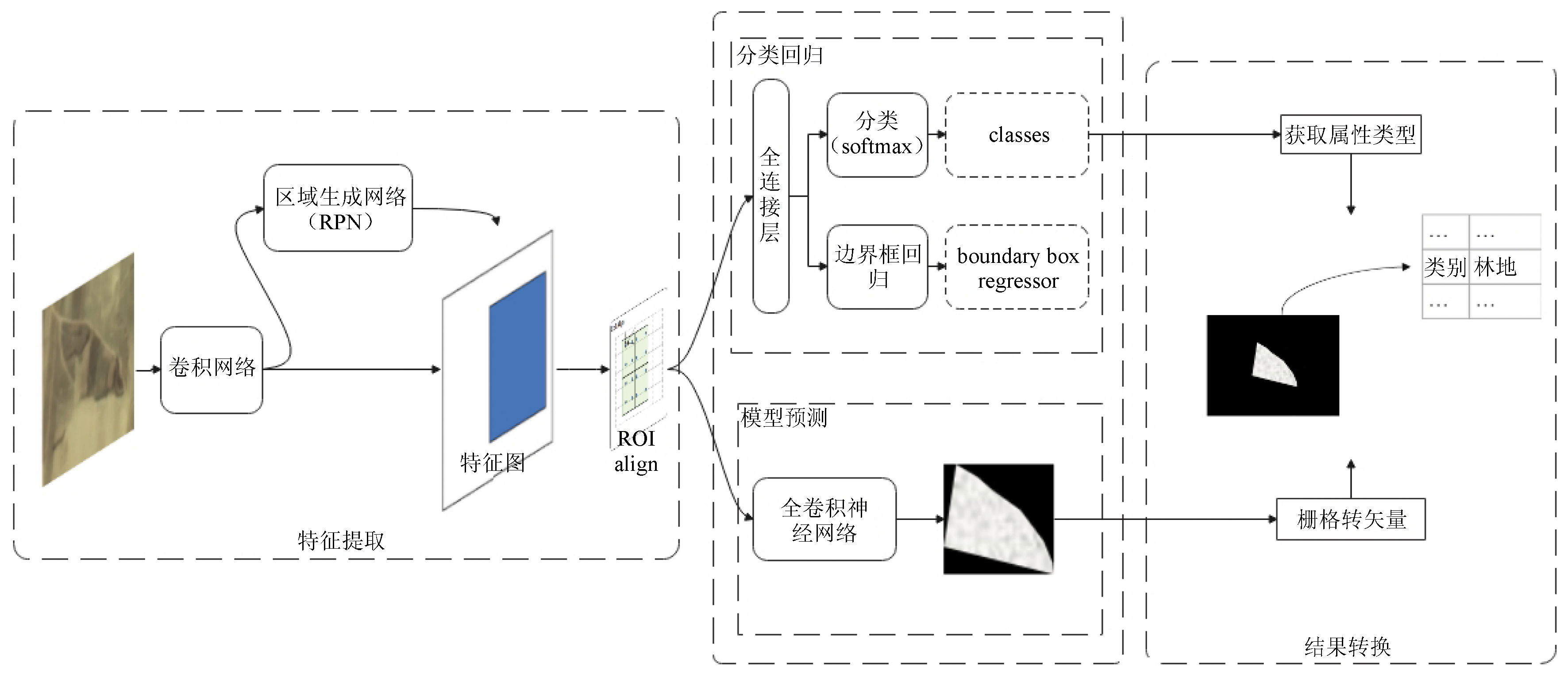
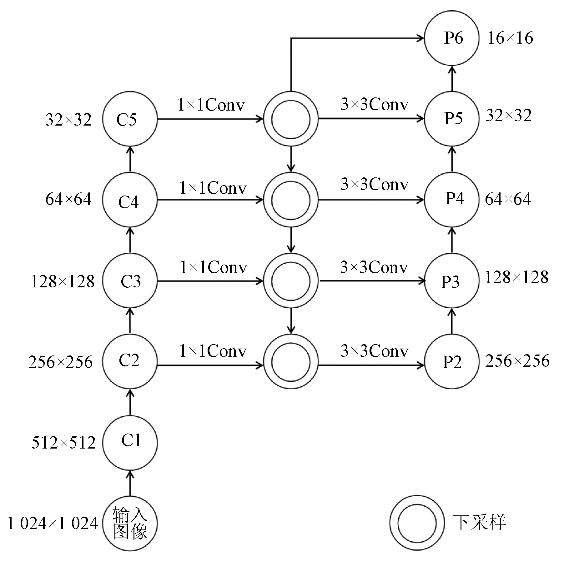
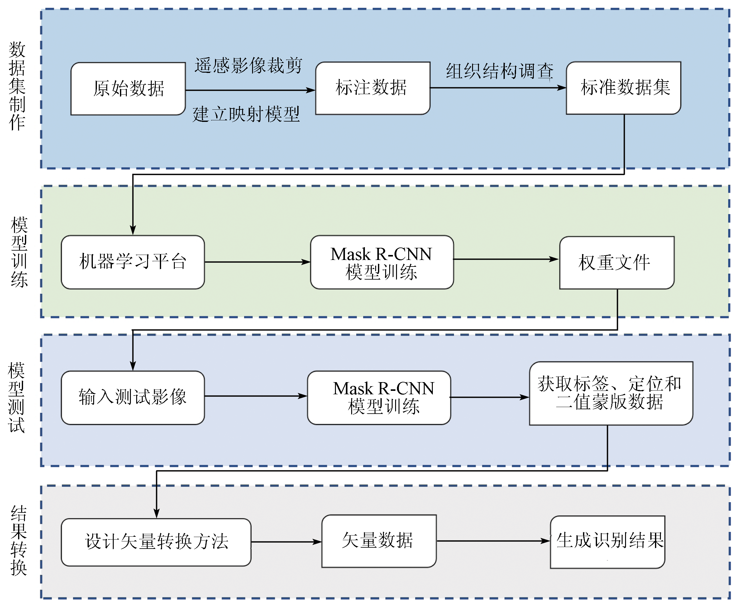
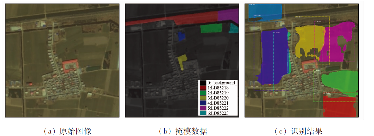
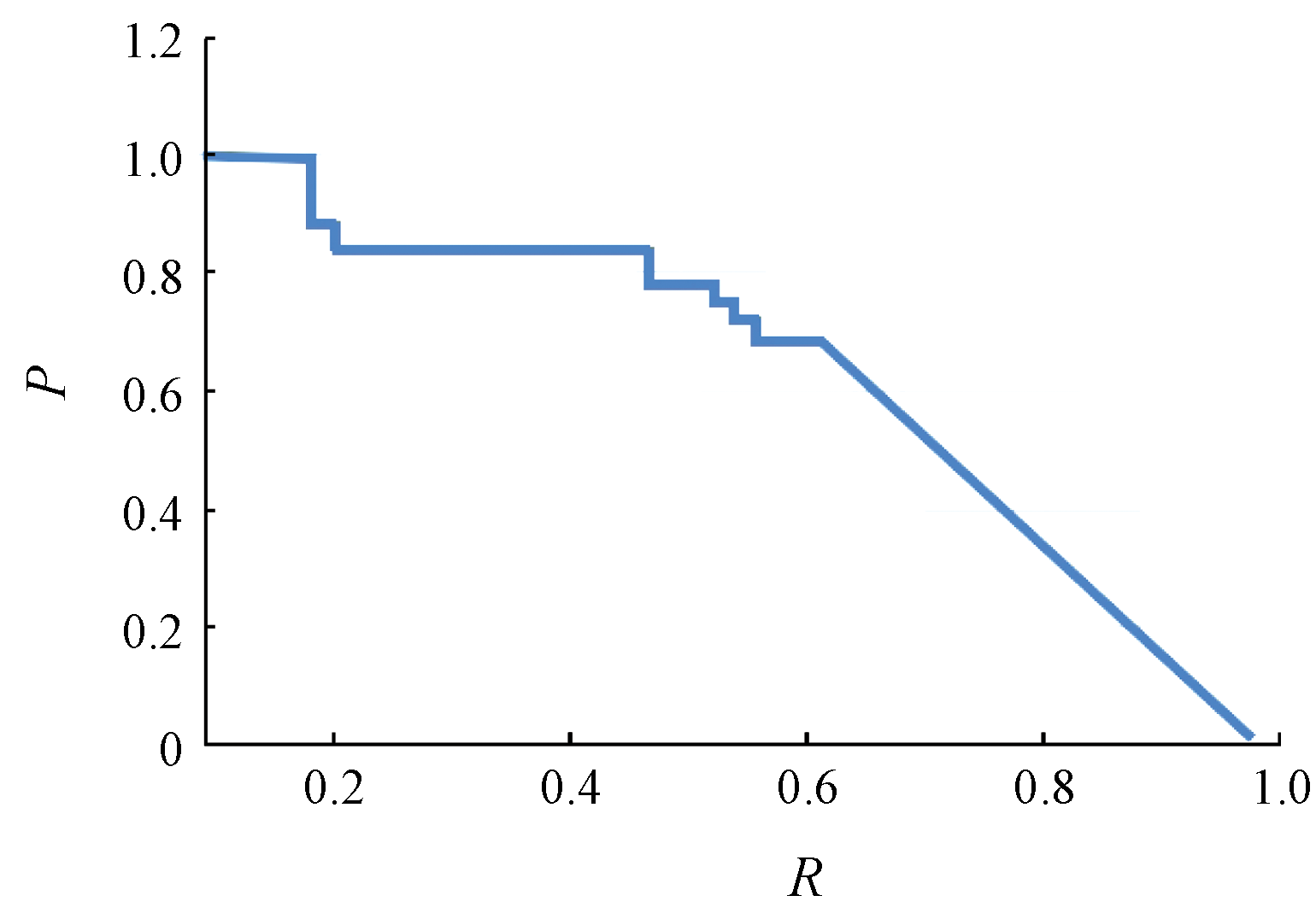
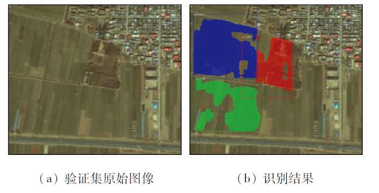
Abstract There are only a few low-accuracy methods available for the feature extraction of sparse woods from remote sensing images. Moreover, there is a lack of datasets for intelligent identification. This study proposed a method for intelligent information identification of sparse woods from remote sensing images. First, a dataset was created using QGIS and Python separately to provide data support for model training. Then, feature maps were generated through feature extraction, and then regions of interest (ROIs) were extracted from the feature maps. Subsequently, these ROIs were filtered through pooling operations (ROI align) to reduce the memory consumption caused by too many ROIs in the images. Experiments show that the method proposed in this study can create datasets quickly and facilitate the identification of sparse woods from remote sensing images. Moreover, the Mask R-CNN-based intelligent identification has a target detection mean average precision (MAP) of up to 0.92.
|
| Keywords
remote sensing image
sparse woods
deep learning
Mask R-CNN
QGIS
|
|
|
|
Issue Date: 07 July 2023
|
|
|
| [1] |
Everingham M, Eslami S M A, Van Gool L, et al. The pascal visual object classes challenge:A retrospective[J]. International Journal of Computer Vision, 2015, 111(1):98-136.
doi: 10.1007/s11263-014-0733-5
url: http://link.springer.com/10.1007/s11263-014-0733-5
|
| [2] |
Lin T, Maire M, Belongie S, et al. Microsoft COCO:Common objects in context[J]. Lecture Notes in Computer Science, 2014, 8693(1):740-755.
|
| [3] |
Alex K, Ilya S, Geoffrey E H. ImageNet classification with deep convolutional neural networks[J]. Communications of the ACM, 2017, 60(6):84-90.
doi: 10.1145/3065386
url: https://dl.acm.org/doi/10.1145/3065386
|
| [4] |
Xia G S, Bai X, Ding J, et al. DOTA:A large-scale dataset for object detection in aerial images[C]// 2018 IEEE/CVF Conference on Computer Vision and Pattern Recognition, 2018:3974-3983.
|
| [5] |
刘立, 彭刚. 高分辨率遥感影像线状地物提取方法研究[J]. 智能城市, 2021, 7(6):63-64.
|
| [5] |
Liu L, Peng G. Research on the extraction method of line features from high-resolution remote sensing images[J]. Intelligent City, 2021, 7(6):63-64.
|
| [6] |
林娜, 陈宏, 李志鹏, 等. 基于GF-1号影像的南方水稻种植信息提取[J]. 地理空间信息, 2021, 19(3):60-63.
|
| [6] |
Lin N, Chen H, Li Z P, et al. Information extraction of southern rice planting based on GF-1 image[J]. Geospatial Information, 2021, 19(3):60-63.
|
| [7] |
张冠宏, 王新军, 徐晓龙, 等. 基于面向对象的无人机遥感影像荒漠植被分类[J]. 中国农业科技导报, 2021, 23(5):69-77.
|
| [7] |
Zhang G H, Wang X J, Xu X L, et al. Desert vegetation classification based on object-oriented UAV remote sensing images[J]. Journal of Agricultural Science and Technology, 2021, 23(5):69-77.
doi: 10.13304/j.nykjdb.2020.0851
|
| [8] |
刘芸, 李雪, 廖瑶, 等. 基于面向对象分类法的贵州烤烟种植区域提取——以烤烟成熟期为例[J]. 贵州科学, 2021, 39(2):82-86.
|
| [8] |
Liu Y, Li X, Liao Y, et al. Extraction of roasted tobacco growing areas in Guizhou based on object-oriented classification method:Taking roasted tobacco maturity period as an example[J]. Guizhou Science, 2021, 39(2):82-86.
|
| [9] |
Ke L, Gang W, Gong C, et al. Object detection in optical remote sensing images:A survey and a new benchmark[J]. ISPRS Journal of Photogrammetry and Remote Sensing, 2020, 159:296-307.
doi: 10.1016/j.isprsjprs.2019.11.023
url: https://linkinghub.elsevier.com/retrieve/pii/S0924271619302825
|
| [10] |
杜敬. 基于深度学习的无人机遥感影像水体识别[J]. 江西科学, 2017, 35(1):158-161,170.
|
| [10] |
Du J. Deep learning based UAV remote sensing image water body identification[J]. Jiangxi Science, 2017, 35(1):158-161,170.
|
| [11] |
范荣双, 陈洋, 徐启恒, 等. 基于深度学习的高分辨率遥感影像建筑物提取方法[J]. 测绘学报, 2019, 48(1):38-45.
|
| [11] |
Fan R S, Chen Y, Xu Q H, et al. A high-resolution remote sensing image building extraction method based on deep learning[J]. Acta Geodaetica et Cartographica Sinica, 2019, 48(1):38-45.
|
| [12] |
刁明光, 于晨, 李文吉, 等. 矿山遥感监测实例分割数据集的自动生成方法[J]. 中国科技论文, 2021, 16(3):329-335.
|
| [12] |
Diao M G, Yu C, Li W J, et al. Automatic generation method of instance segmentation data set in mine remote sensing monitoring[J]. China Sciencepaper, 2021, 16(3):329-335.
|
| [13] |
Menapace A, Pisaturo G R, De Luca A, et al. EPANET in QGIS framework:The QEPANET plugin[J]. Journal of Water Supply:Research and Technology-Aqua, 2020, 69(1):1-5.
doi: 10.2166/aqua.2019.087
url: https://iwaponline.com/aqua/article/69/1/1/70433/EPANET-in-QGIS-framework-the-QEPANET-plugin
|
| [14] |
Zhang W W, Wang K F, Wang Y T, et al. A loss-balanced multi-task model for simultaneous detection and segmentation[J]. Neurocomputing, 2021, 428:65-78.
doi: 10.1016/j.neucom.2020.11.024
url: https://linkinghub.elsevier.com/retrieve/pii/S0925231220318105
|
| [15] |
He K, Gkioxari G, Dollár P, et al. Mask R-CNN[J]. IEEE Transactions on Pattern Analysis and Machine Intelligence, 2020, 42(2):386-397.
doi: 10.1109/TPAMI.2018.2844175
pmid: 29994331
|
| [16] |
Huang Y J, Xu H X. Fully convolutional network with attention modules for semantic segmentation[J]. Signal,Image and Video Processing, 2021, 15(5):1031-1039.
doi: 10.1007/s11760-020-01828-8
|
| [17] |
Miao J, Xu S W, Zou B X, et al. ResNet based on feature-inspired gating strategy[J]. Multimedia Tools and Applications, 2022, 81(4):19283-19300.
doi: 10.1007/s11042-021-10802-6
|
| [18] |
Bai T, Pang Y, Luo J S, et al. An optimized faster R-CNN method based on DRNet and RoI align for building detection in remote sensing images[J]. Remote Sensing, 2020, 12(5):762.
doi: 10.3390/rs12050762
url: https://www.mdpi.com/2072-4292/12/5/762
|
| [19] |
孙禧勇, 许玮, 姜德才, 等. 基于遥感的雄安新区地表水时序变化与区域规划研究[J]. 地球物理学进展, 2021, 36(4):1443-1455.
|
| [19] |
Sun X Y, Xu W, Jiang D C, et al. Research on time series changing trend of surface water and regional planning in Xiong’an New Area based on remote sensing[J]. Progress in Geophysics, 2021, 36(4):1443-1455.
|
|
Viewed |
|
|
|
Full text
|
|
|
|
|
Abstract
|
|
|
|
|
Cited |
|
|
|
|
| |
Shared |
|
|
|
|
| |
Discussed |
|
|
|
|
 2023,
Vol. 35
2023,
Vol. 35