|
|
 |
|

|
|
|
Application of the time-series InSAR technology in the identification of geological hazards in the Pearl River Delta region |
JIANG Decai1,2,3( ), ZHENG Xiangxiang2,3,4, WANG Ning3, XIAO Chunlei3(), ZHU Zhenzhou3 ), ZHENG Xiangxiang2,3,4, WANG Ning3, XIAO Chunlei3(), ZHU Zhenzhou3 |
1. Northwest Institute of Eco-Environment and Resources,Chinese Academy of Sciences,Lanzhou 730000,China
2. University of Chinese Academy of Sciences,Beijing 100049,China
3. China Aero Geophysical Survey and Remote Sensing Center for Natural Resources,Beijing 100083,China
4. Aerospace Information Research Institute,Chinese Academy of Sciences,Beijing 100094,China |
|
|
|
|
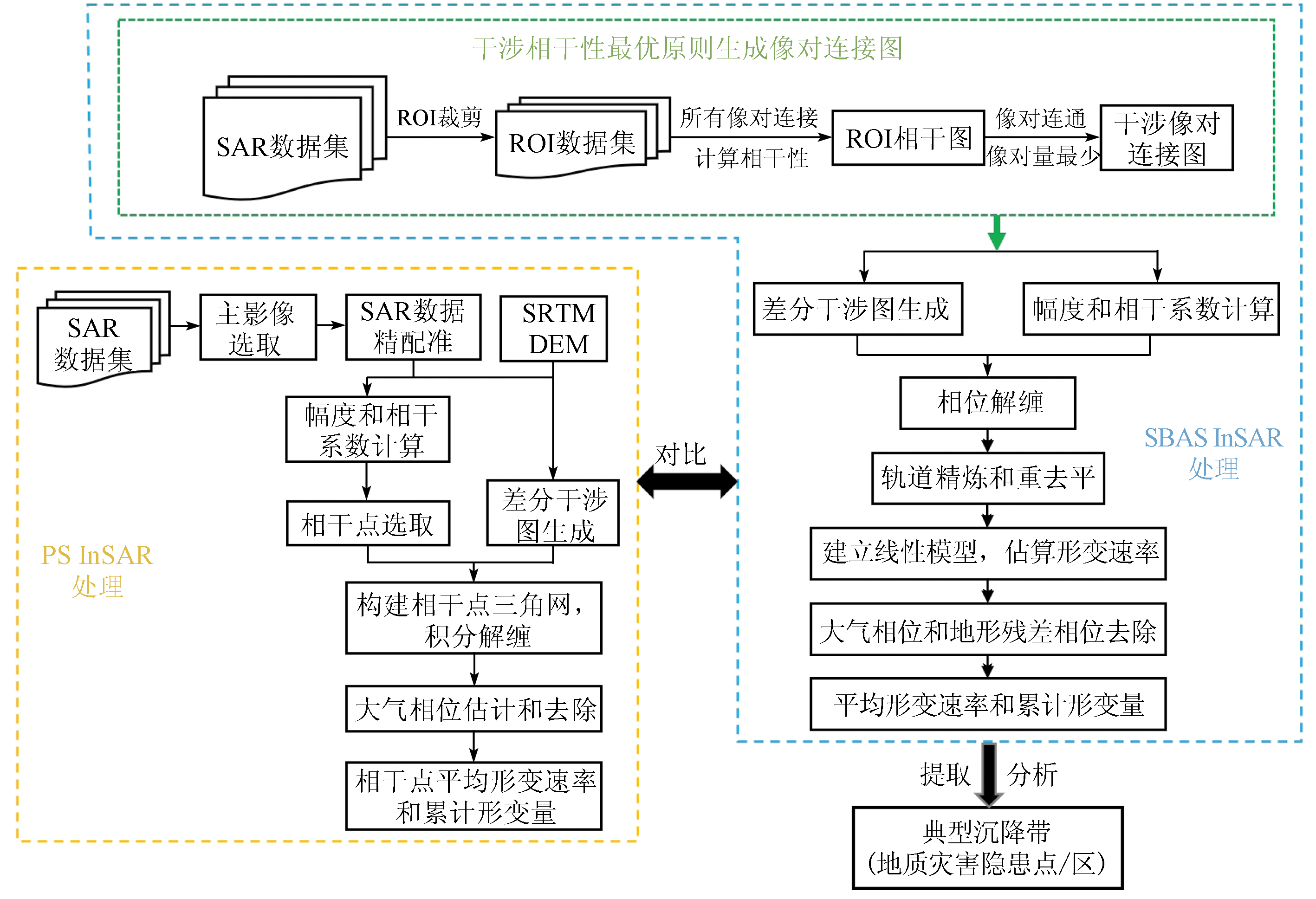
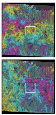
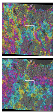
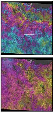
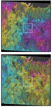
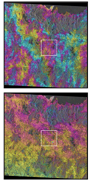
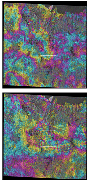
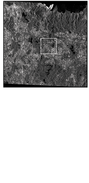
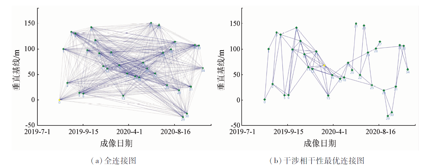
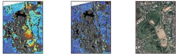
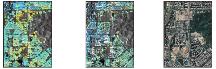
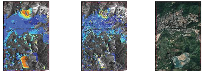
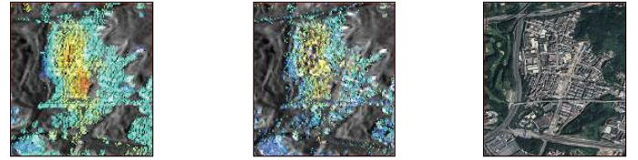
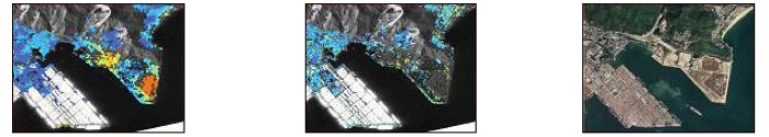
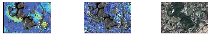
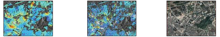
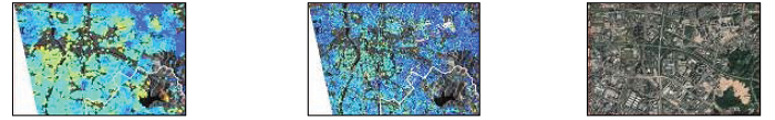
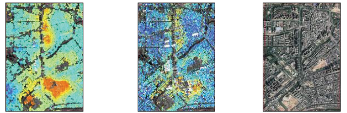
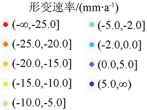
Abstract In the Pearl River Delta (PRD) region, widespread surface water and vegetation are liable to cause interferometric synthetic aperture Radar (InSAR) interference decoherence, and the cloudy, foggy, rainy, and humid climates frequently cause severe atmospheric delay noise in InSAR data. Accordingly, targeting the Longgang District of Shenzhen City in the southeastern PRD, this study generated the connection graph of interference image pairs using the small baseline subset and InSAR (SBAS InSAR) technique based on interference coherence optimization. This study also obtained the surface deformation information of Longgang District from September 2019 to November 2020 based on 35 scenes of Sentinel-1A images. It then compared the surface deformation information with the inversion results obtained using the persistent scatterer InSAR (PS InSAR) technique. Finally, this study deduced the causes of surface deformation. The results are as follows: ① The inversion results of SBAS InSAR and PS InSAR yielded almost the same surface deformation fields. SBAS InSAR exhibited a much higher coherent point density than PS InSAR in the region with high-amplitude deformation. This indicates that the SBAS InSAR based on the optimal interference coherence can yield accurate and reliable inversion results, enjoying more advantages in the inversion for a complete deformation field. ② The primary causes of surface deformation in Longgang District and its surrounding areas include unstable Karst collapse or slope triggered by continuous heavy rainfall, the changes in the underground hydrogeological environment caused by industrial mining and drainage, the subsidence of mining gob induced by underground construction, and static foundation load imposed by new high-rise buildings. The technical route of this study can provide a reference for the automation and engineering application of InSAR in the early identification of geological hazards in the PRD region.
|
| Keywords
interference coherence optimization
Pearl River Delta
Longgang District
InSAR
|
|
|
|
Issue Date: 19 September 2023
|
|
|
| [1] |
刘飞. 基于GIS的地质灾害风险性评价——以龙岗区为例[D]. 长春: 吉林大学, 2020.
|
| [1] |
Liu F. Risk assessment of geological hazards based on GIS:A case study of Longgang District[D]. Changchun: Jilin University, 2020.
|
| [2] |
徐娜. 深圳龙岗:主动作为勇于创新打造风险普查特色模式[J]. 中国减灾, 2021, 7(5):30-33.
|
| [2] |
Xu N. Shenzhen Longgang: Take the initiative to create a risk census characteristic mode as the courage to innovate[J]. Disaster Reduction in China, 2021, 7(5):30-33.
|
| [3] |
葛大庆. 区域性地面沉降InSAR监测关键技术研究[D]. 北京: 中国地质大学(北京), 2013.
|
| [3] |
Ge D Q. Research on the key techniques of SAR interferometry for regional land subsidence monitoring[D]. Beijing: China University of Geosciences (Beijing), 2013.
|
| [4] |
朱建军, 李志伟, 胡俊. InSAR变形监测方法与研究进展[J]. 测绘学报, 2017, 46(10):1717-1733.
doi: 10.11947/j.AGCS.2017.20170350
|
| [4] |
Zhu J J, Li Z W, Hu J. Research process and method of InSAR for deformation monitoring[J]. Acta Geodaetica et Cartographica Sinica, 2017, 46(10):1717-1733.
|
| [5] |
张永红, 刘冰, 吴宏安, 等. 雄安新区2012—2016年地面沉降InSAR监测[J]. 地球科学与环境学报, 2018, 40(5):152-162.
|
| [5] |
Zhang Y H, Liu B, Wu H A, et al. Ground subsidence in Xiong’an New Area from 2012 to 2016 monitoring by InSAR techniques[J], Journal of Earch Sciences and Environment, 2018, 40(5):152-162.
|
| [6] |
Lu Z, Zhang J X, Zhang Y H, et al. Monitoring and characterizing natural hazards with satellite InSAR imagery[J]. Geographic Information Sciences, 2010, 16(1):55-66.
|
| [7] |
葛大庆, 戴可人, 郭兆成, 等. 重大地质灾害隐患早期识别中综合遥感应用的思考与建议[J]. 武汉大学学报(信息科学版), 2019, 44(7):4-11.
|
| [7] |
Ge D Q, Dai K R, Guo Z C, et al. Early identification of serious geo-logical hazards with integrated remote sensing technnologies:Thoughts and recommendations[J]. Geomatics and Information Science of Wuhan University, 2019, 44(7):4-11.
|
| [8] |
许强. 对地质灾害隐患早期识别相关问题的认识与思考[J]. 武汉大学学报(信息科学版), 2020, 45(11):1651-1659.
|
| [8] |
Xu Q. Understanding and consideration of related issues in early identificaiton of potential geohazards[J]. Geomatics and Information Science of Wuhan University, 2020, 45(11):1651-1659.
|
| [9] |
廖明生, 董杰, 李梦华, 等. 雷达遥感滑坡隐患识别与形变监测[J]. 遥感学报, 2021, 25(1):332-341.
|
| [9] |
Liao M S, Dong J, Li M H, et al. Radar remote sensing for potential landslides detection and deformation monitoring[J]. National Remote Sensing Bulletin, 2021, 25(1):332-341.
doi: 10.11834/jrs.20210162
url: http://www.ygxb.ac.cn/zh/article/doi/10.11834/jrs.20210162/
|
| [10] |
唐伟, 廖明生, 张丽, 等. 基于全球气象再分析资料的InSAR对流层延迟改正研究[J]. 地球物理学报, 2017, 60(2):527-540.
|
| [10] |
Tang W, Liao M S, Zhang L, et al. Study on InSAR tropospheric correction using global atmospheric reanalysis products[J]. Chinese Journal of Geophysics, 2017, 60(2):527-540.
|
| [11] |
朱邦彦. InSAR对流层延迟校正及其在地表沉降监测中的应用研究[D]. 武汉: 武汉大学, 2017.
|
| [11] |
Zhu B Y. Research on tropospheric delay correction of SAR interferometry and its application in land subsidence monitoring[D]. Wuhan: Wuhan University, 2017.
|
| [12] |
Berardino P, Fornaro G, Lanari R, et al. A new algorithm for surface deformation monitoring based on small baseline differential SAR interferograms[J]. IEEE Transactions on Geoscience and Remote Sensing, 2002, 40(11):2375-2383.
doi: 10.1109/TGRS.2002.803792
url: http://ieeexplore.ieee.org/document/1166596/
|
| [13] |
Casu F, Manzo M, Pepe A, et al. SBAS-DInSAR analysis of very extended areas:First results on a 60 000-km2 test site[J]. IEEE Geoscience and Remote Sensing Letters, 2008, 5(3): 438-442.
doi: 10.1109/LGRS.2008.916199
url: http://ieeexplore.ieee.org/document/4510663/
|
| [14] |
Baek W K, Jung H S. Precise three-dimensional deformation retrieval in large and complex deformation areas via integration of offset-based unwrapping and improved multiple-aperture SAR interferometry:Application to the 2016 Kumamoto earthquake[J]. Engineering, 2020, 6(8): 927-935
doi: 10.1016/j.eng.2020.06.012
url: https://linkinghub.elsevier.com/retrieve/pii/S2095809918311937
|
| [15] |
Ding J, Zhao Q, Tang M, et al. On the characterization and forecasting of ground displacements of ocean-reclaimed lands[J]. Remote Sensing, 2020, 12(18):2971.
doi: 10.3390/rs12182971
url: https://www.mdpi.com/2072-4292/12/18/2971
|
| [16] |
王国强, 陈仁琛. 基于InSAR技术的流域库岸地质灾害监测研究[J]. 中国农村水利水电, 2020, 458(12):212-216.
|
| [16] |
Wang G Q, Chen R C. Reseatrch on the monitoring of geological hazards on the bank reservoir based on InSAR technology[J]. China Rural Water and Hydropower, 2020, 458(12):212-216.
|
| [17] |
Ferretti A, Prati C. Nonlinear subsidence rate estimation using permanent scatterers in differential SAR interferometry[J]. IEEE Transactions on Geoscience and Remote Sensing, 2000, 38(5):2202-2212.
doi: 10.1109/36.868878
url: http://ieeexplore.ieee.org/document/868878/
|
| [18] |
Ferretti A, Prati C, Rocca F. Permanent scatterers in SAR interfero-metry[J]. IEEE Transactions on Geoscience and Remote Sensing, 2001, 39(1):8-20.
doi: 10.1109/36.898661
url: http://ieeexplore.ieee.org/document/898661/
|
| [19] |
Kim J S, Kim D J, Kim S W, et al. Monitoring of urban land surface subsidence using PSInSAR[J]. Geosciences Journal, 2007, 11(1):59-73.
doi: 10.1007/BF02910381
url: http://link.springer.com/10.1007/BF02910381
|
| [20] |
Zhang L, Ding X L, Lu Z. Modeling PSInSAR time series without phase unwrapping[J]. IEEE Transactions on Geoscience and Remote Sensing, 2011, 49(1):547-556
doi: 10.1109/TGRS.2010.2052625
url: http://ieeexplore.ieee.org/document/5518395/
|
| [21] |
侯安业, 张景发, 刘斌, 等. PS-InSAR与SBAS-InSAR监测地表沉降的比较研究[J]. 大地测量与地球动力学, 2012, 32(4):125-128.
|
| [21] |
Hou A Y, Zhang J F, Liu B, et al. Comparative study on monitoring surface subsidence with PS-InSAR and SBAS-InSAR[J]. Journal of Geodesy and Geodynamics, 2012, 32(4):125-128.
|
| [22] |
深圳市规划和自然资源局. 深圳市地质灾害防治规划(2016—2025年)[EB/OL].(2018-07-13) [2022-05-08]http://www.sz.gov.cn/cn/xxgk/zfxxgj/ghjh/csgh/zxgh/content/post_1317024.html.
url: http://www.sz.gov.cn/cn/xxgk/zfxxgj/ghjh/csgh/zxgh/content/post_1317024.html
|
| [22] |
Planning and Natural Resources Bureau of Shenzhen Municipality. Plan for prevention and control of geological hazards of Shenzhen Municipality (2016—2025)[EB/OL].(2018-07-13) [2022-05-08]http://www.sz.gov.cn/cn/xxgk/zfxxgj/ghjh/csgh/zxgh/content/post_1317024.html.
url: http://www.sz.gov.cn/cn/xxgk/zfxxgj/ghjh/csgh/zxgh/content/post_1317024.html
|
| [23] |
中国地质调查局. 地质云3.0[DB/OL].(2021-03-11) [2022-05-08]http://geocloud.cgs.gov.cn.
url: http://geocloud.cgs.gov.cn
|
| [23] |
China Geological Survey. Geocloud 3.0[DB/OL].(2021-03-11) [2022-05-08]http://geocloud.cgs.gov.cn.v
url: http://geocloud.cgs.gov.cn
|
|
Viewed |
|
|
|
Full text
|
|
|
|
|
Abstract
|
|
|
|
|
Cited |
|
|
|
|
| |
Shared |
|
|
|
|
| |
Discussed |
|
|
|
|
 2023,
Vol. 35
2023,
Vol. 35