|
|
 |
|

|
|
|
Comparative study on atmospheric correction methods for ZY-1 02D hyperspectral data for geological applications |
LI Na1( ), DONG Xinfeng1,2(), WANG Jinglan3, CHEN Li1, GAN Fuping1, LI Tongtong2, ZHANG Shifan2 ), DONG Xinfeng1,2(), WANG Jinglan3, CHEN Li1, GAN Fuping1, LI Tongtong2, ZHANG Shifan2 |
1. China Aero Geophysical Survey and Remote Sensing Center for Natural Resources, Beijing 100083, China
2. School of Earth Sciences and Resource,China University of Geosciences(Beijing),Beijing 100083, China
3. Sichuan Water Conservancy Vocational College,Chengdu 610000, China |
|
|
|
|
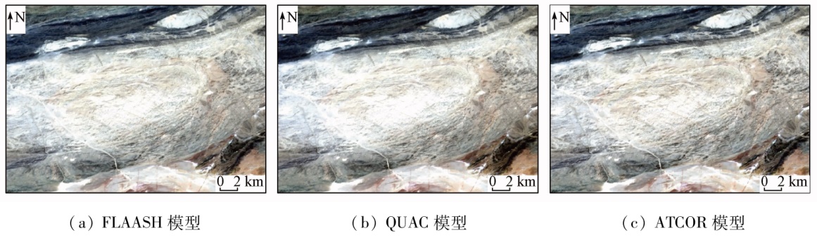
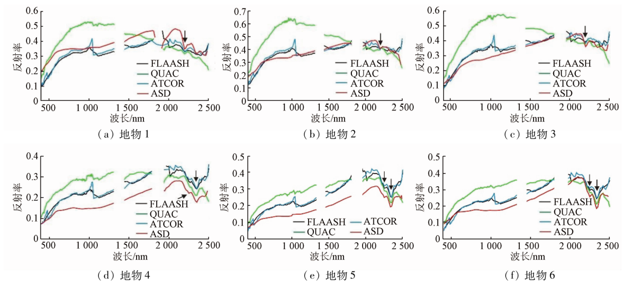
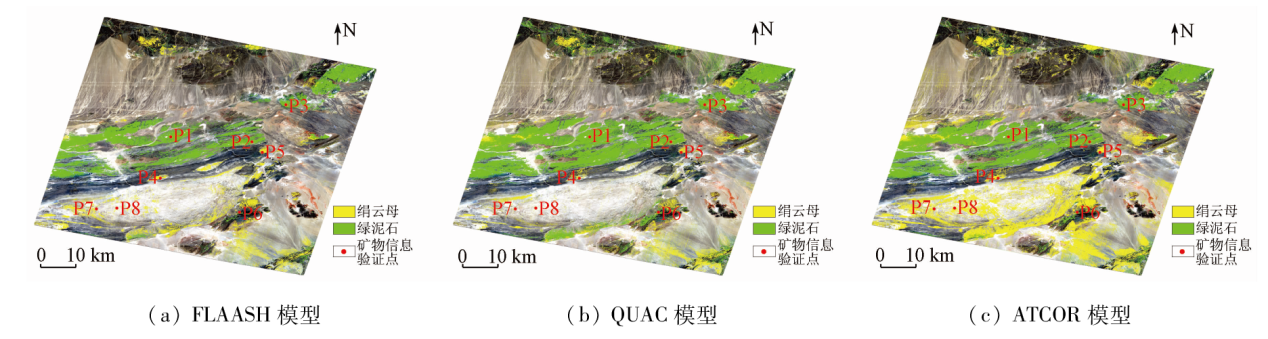
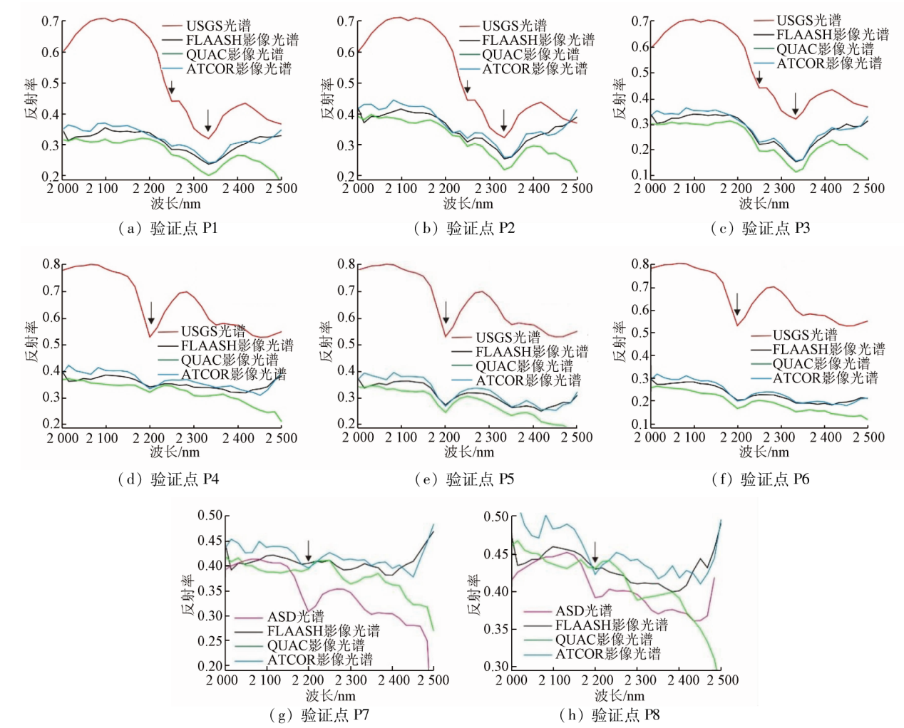
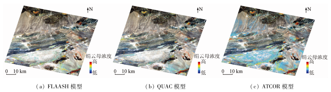
Abstract Hyperspectral data, exhibiting technical advantages in the spectral dimension, have been extensively used for accurately identifying surface features, particularly mineral information. Mineral identification relies on hyperspectral reflectance products, necessitating the application of proper atmospheric correction methods to obtain high-precision surface reflectance products that meet application requirements. Hence, three commonly used atmospheric correction models, ATCOR, FLAASH, and QUAC, were utilized to correct the hyperspectral data acquired by the ZY-1 02D satellite. Moreover, a comparative analysis was conducted on their visual effects, spectral analysis of typical surface features, and extraction of mineral information. The results are as follows: ① All three atmospheric correction models can effectively enhance image clarity in terms of visual effects. Specifically, the ATCOR model slightly outperformed the FLAASH and QUAC models; ② The correlation coefficients (R2) between the typical surface feature spectra of the three models and the ASD-measured spectra showed average values exceeding 0.7, suggesting high consistency and accuracy. Especially, the imaging spectra derived from the inversion results of the ATCOR model were more similar to the ASD-measured spectra; ③ The three models yielded relatively consistent results in chlorite identification but divergent results in sericite identification. Comparatively, the FLAASH and QUAC models exhibited high omission rates in surface regions with low sericite content. Overall, all three models can achieve satisfactory atmospheric correction effects, but the ATCOR model is superior to the other two models in mineral identification.
|
| Keywords
ZY-1 02D
atmospheric correction
ATCOR
FLAASH
QUAC
mineral identification
|
|
|
|
Issue Date: 21 December 2023
|
|
|
| [1] |
王茜, 任广利. 高光谱遥感异常信息在阿尔金索拉克地区铜金矿找矿工作中的应用[J]. 自然资源遥感, 2022, 34(1):277-285.doi:10.6046/zrzyyg.2021036.
|
| [1] |
Wang Q, Ren G L. Application of hyperspectral remote sensing data-based anomaly extraction in copper-gold prospecting in the Solake area in the Altyn metallogenic belt,Xinjiang[J]. Remote Sensing for Natural Resources, 2022, 34(1):277-285.doi:10.6046/zrzyyg.2021036.
|
| [2] |
王瑞军, 张春雷, 孙永彬, 等. 高光谱在甘肃红山多金属找矿模型构建中的应用[J]. 国土资源遥感, 2020, 32(3):222-231.doi:10.6046/gtzyyg.2020.03.29.
|
| [2] |
Wang R J, Zhang C L, Sun Y B, et al. Application of hyperspectral spectroscopy to constructing polymetallic prospecting model in Hongshan,Gansu Province[J]. Remote Sensing for Land and Resources, 2020, 32(3):222-231.doi:10.6046/gtzyyg.2020.03.29.
|
| [3] |
董新丰, 闫柏琨, 李娜, 等. 基于航空高光谱遥感的沉积变质型铁矿找矿预测——以北祁连镜铁山地区为例[J]. 地质与勘探, 2018, 54(5): 1013-1023.
|
| [3] |
Dong X F, Yan B K, Li N, et al. Prospecting prediction of sedimentary metamorphic type iron deposits based on airborne hyperspectral remote sensing:A case study of the Jingtieshan area in the northern Qilian Mountains[J]. Geology and Exploration, 2018, 54(5): 1013-1023.
|
| [4] |
Van Ruitenbeek F, Cudahy T J, van der Meer F, et al. Characterization of the hydrothermal systems associated with Archean VMS-mineralization at Panorama,Western Australia,using hyperspectral,geochemical and geothermometric data[J]. Ore Geology Reviews, 2012, 45: 33-46.
doi: 10.1016/j.oregeorev.2011.07.001
url: https://linkinghub.elsevier.com/retrieve/pii/S0169136811000692
|
| [5] |
Bell J H, Bowen B B, Martini B A. Imaging spectroscopy of jarosite cement in the Jurassic Navajo Sandstone[J]. Remote Sensing of Environment, 2010, 114(10): 2259-2270.
doi: 10.1016/j.rse.2010.05.002
url: https://linkinghub.elsevier.com/retrieve/pii/S0034425710001422
|
| [6] |
Carrino T A, Crósta A P, Toledo C, et al. Hyperspectral remote sensing applied to mineral exploration in southern Peru:A multiple data integration approach in the Chapi Chiara gold prospect[J]. International Journal of Applied Earth Observation and Geoinformation, 2018, 64:287-300.
doi: 10.1016/j.jag.2017.05.004
url: https://linkinghub.elsevier.com/retrieve/pii/S0303243417301071
|
| [7] |
李娜, 董新丰, 甘甫平, 等. 资源一号02D卫星高光谱数据地质调查应用评价[J]. 航天器工程, 2020, 29(6):186-191.
|
| [7] |
Li N, Dong X F, Gan F P, et al. Application evaluation of ZY-1-02D satellite hyperspectral data in geological survey[J]. Spacecraft Engineering, 2020, 29(6):186-191.
|
| [8] |
Molkov A, Fedorov S, Pelevin V. Toward atmospheric correction algorithms for Sentinel-3/OLCI images of productive waters[J]. Remote Sensing, 2022, 14(15):3663.
doi: 10.3390/rs14153663
url: https://www.mdpi.com/2072-4292/14/15/3663
|
| [9] |
Kaufman Y J, Gao B C. Remote sensing of water vapor in the near IR from EOS/MODIS[J]. IEEE Transactions on Geoscience and Remote Sensing, 1992, 30(5): 871-884.
doi: 10.1109/36.175321
url: http://ieeexplore.ieee.org/document/175321/
|
| [10] |
Smith G M, Milton E J. The use of the empirical line method to calibrate remotely sensed data to reflectance[J]. International Journal of Remote Sensing, 1999, 20(13):2653-2662.
doi: 10.1080/014311699211994
url: https://www.tandfonline.com/doi/full/10.1080/014311699211994
|
| [11] |
Goetz A, Calvin W M. Imaging spectrometry:Spectral resolution and analytical identification of spectral features[C]// Proceedings of SPIE - The International Society for Optical Engineering, 1987, 834: 158-165.
|
| [12] |
Ostrikov V N, Plakhotnikov O V, Kirienko A V. Estimation of spectral resolution of imaging spectrometers from Fraunhofer lines with the MODTRAN atmospheric model[J]. Atmospheric and Oceanic Optics, 2019, 32(6):622-627.
doi: 10.1134/S1024856019060101
|
| [13] |
Yang M M, Hu Y, Tian H Z, et al. Atmospheric correction of airborne hyperspectral CASI data using polymer,6S and FLAASH[J]. Remote Sensing, 2021, 13(24):5062.
doi: 10.3390/rs13245062
url: https://www.mdpi.com/2072-4292/13/24/5062
|
| [14] |
Maher A, Ghazzl N K. Removing atmospheric effects for multi spectral images (OLI 8) using ATCOR model[J]. IOP Conference Series:Materials Science and Engineering, 2020, 757(1):012072.
doi: 10.1088/1757-899X/757/1/012072
|
| [15] |
王正海, 段建军, 耿欣. 基于波谱匹配的Hyperion数据大气校正方法对比研究[J]. 遥感技术与应用, 2011, 26(4):432-436.
|
| [15] |
Wang Z H, Duan J J, Geng X. Comparative study on atmospheric correction methods of Hyperion data based on spectral matching[J]. Remote Sensing Technology and Application, 2011, 26(4):432-436.
|
| [16] |
Kruse F A. Comparison of ATREM,ACORN,and FLAASH atmospheric corrections using low-altitude AVIRIS data of Boulder,CO[J/OL]. JPL Airborne Geoscience Workshop, 2014(2014-05-26)[2022-04-14].https://citeseerx.ist.psu.edu/viewdoc/download?doi=10.1.1.569.8864&rep=rep1&type=pdf.
url: https://citeseerx.ist.psu.edu/viewdoc/download?doi=10.1.1.569.8864&rep=rep1&type=pdf
|
| [17] |
Rani N R, Mandla V R, Singh T. Evaluation of atmospheric corrections on hyperspectral data with special reference to mineral mapping[J]. Geoscience Frontiers, 2017, 8(4):797-808.
doi: 10.1016/j.gsf.2016.06.004
url: https://linkinghub.elsevier.com/retrieve/pii/S1674987116300603
|
| [18] |
田青林, 秦凯, 陈雪娇, 等. WorldView-3卫星影像大气校正方法应用对比研究[J]. 世界核地质科学, 2021, 38(2):229-236.
|
| [18] |
Tian Q L, Qin K, Chen X J, et al. Comparison research on the application of atmospheric correction methods for WorldView-3 satellite imagery[J]. World Nuclear Geoscience, 2021, 38(2):229-236.
|
| [19] |
梁树能, 甘甫平, 魏红艳, 等. 哈密遥感地质资源评价综合应用野外试验场建设进展[J]. 国土资源遥感, 2015, 27(2):8-14.doi:10.6046/gtzyyg.2015.02.02.
|
| [19] |
Liang S N, Gan F P, Wei H Y, et al. Progress in construction of remote sensing and geological test field for comprehensive application and resources evaluation in Hami,Xinjiang[J]. Remote Sensing for Land and Resources, 2015, 27(2):8-14.doi:10.6046/gtzyyg.2015.02.02.
|
| [20] |
梁树能, 甘甫平, 张振华, 等. 国内外遥感试验场建设进展[J]. 地质力学学报, 2015, 21(2):129-141.
|
| [20] |
Liang S N, Gan F P, Zhang Z H, et al. Introduction of the remote sensing test field site construction progress at home and abroad[J]. Journal of Geomechanics, 2015, 21(2):129-141.
|
| [21] |
Matthew M W, Adler-Golden S M, Berk A, et al. Atmospheric correction of spectral imagery:Evaluation of the FLAASH algorithm with AVIRIS data[C]// Applied Imagery Pattern Recognition Workshop.IEEE, 2003:157-163.
|
| [22] |
Maher A. Evaluation of atmospherically gases using models FLAASH and QUAC to hyper-spectral imagery[J]. Karbala International Journal of Modern Science, 2019, 5(4):213-225.
|
| [23] |
刘安伟. 基于模拟多光谱遥感影像的大气校正方法比较研究[J]. 矿山测量, 2018, 46(2):10-13,26.
|
| [23] |
Liu A W. Comparison of atmospheric correction methods based on simulated multi-spectral remote sensing images[J]. Mine Surveying, 2018, 46(2):10-13,26.
|
| [24] |
Wang C L, Yang F, Wang H W, et al. Urban house fetection using SAM and SIFT on hyperspectral remote sensing images[J]. Journal of Physics:Conference Series, 2019, 1237(3):032029.
doi: 10.1088/1742-6596/1237/3/032029
|
|
Viewed |
|
|
|
Full text
|
|
|
|
|
Abstract
|
|
|
|
|
Cited |
|
|
|
|
| |
Shared |
|
|
|
|
| |
Discussed |
|
|
|
|
 2023,
Vol. 35
2023,
Vol. 35